1856 Indiana Map - Vintage State Map by Colton (Restored) for Collectors
Indiana Map
1856 Indiana Map — Vintage State Map by Colton (Restored)
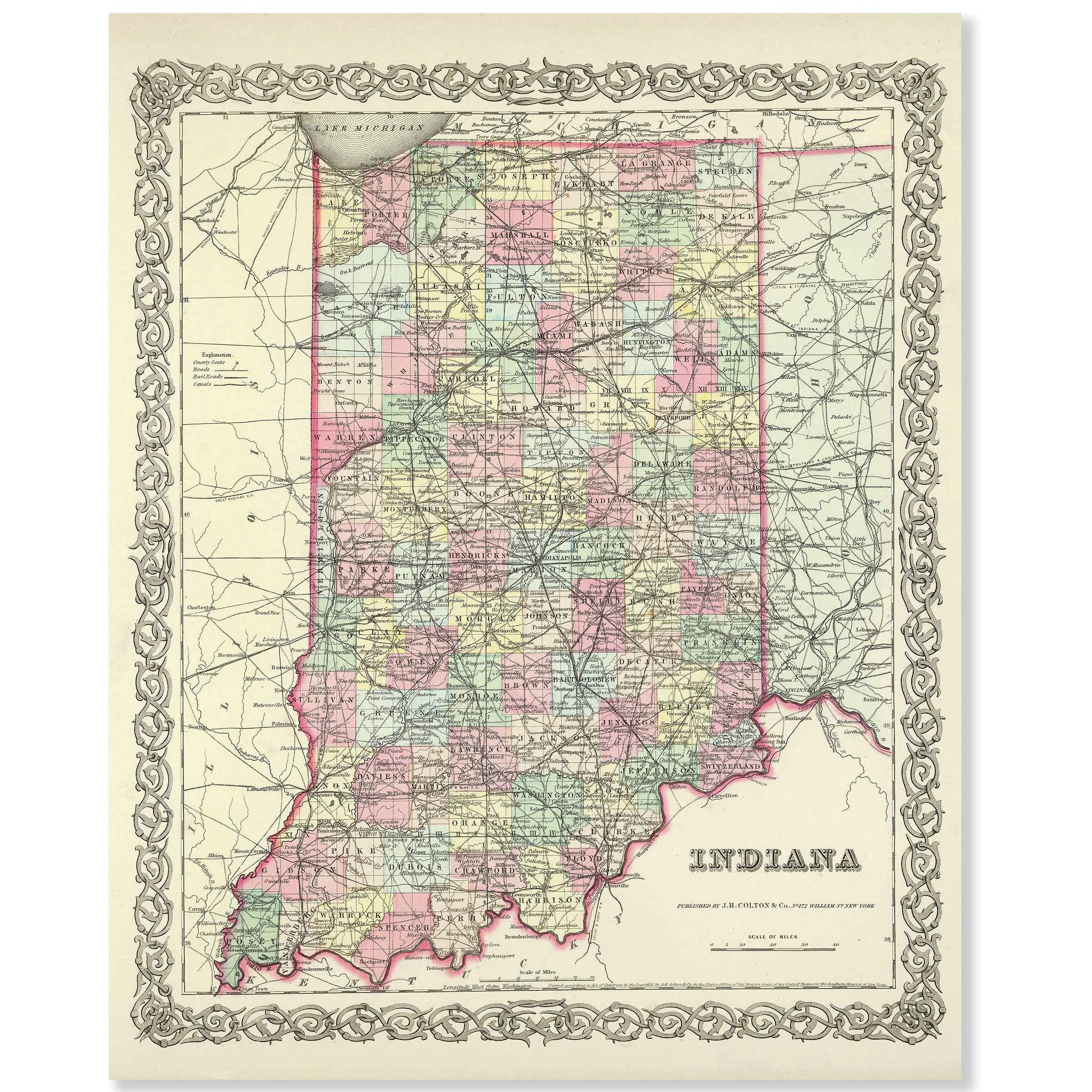
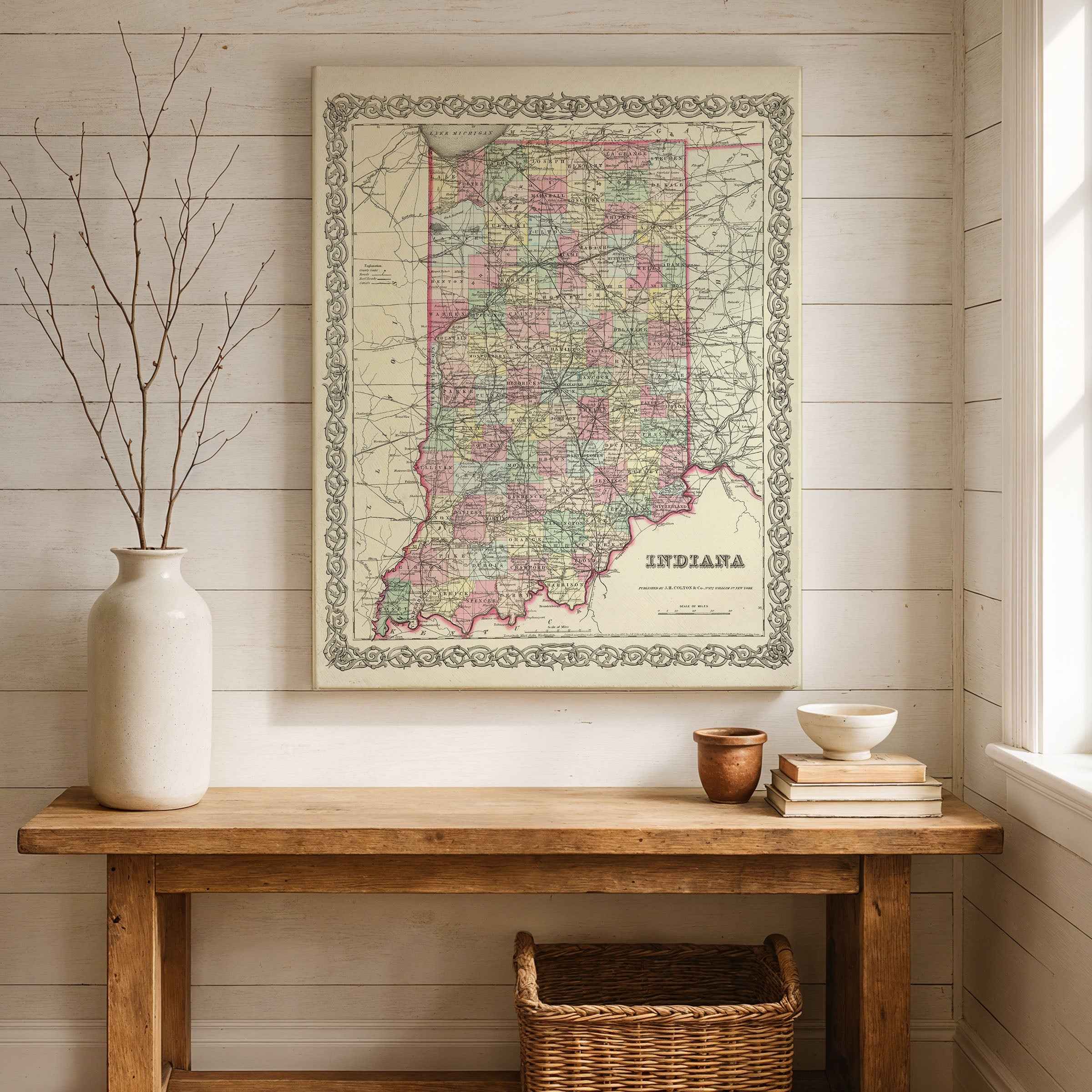
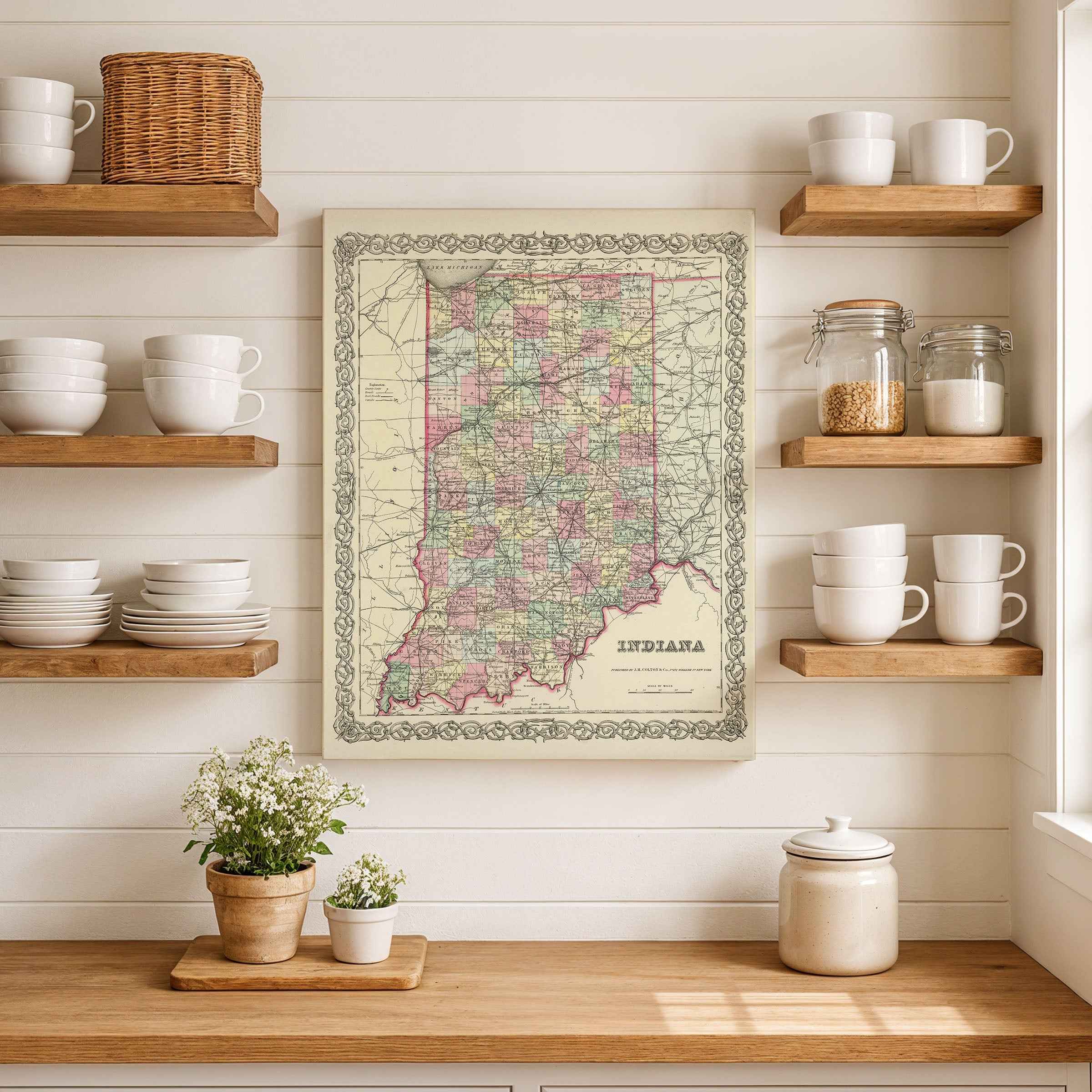
Step back into the mid-19th century and experience Indiana during a pivotal era with this beautifully restored 1856 map by George W. Colton. Originally published in his celebrated atlas, this historic engraving captures Indiana’s evolving counties, towns, rivers, and early railroads at a time when the state was rapidly modernizing. Every line and detail has been carefully preserved, including an inset that highlights the growing presence of Indianapolis as the state capital.
Each reproduction is meticulously restored to showcase the artistry and accuracy of Colton’s work, making it the perfect centerpiece for collectors, historians, or anyone with ties to Indiana’s heritage. Whether displayed in a home, office, library, or classroom, this map is more than wall art—it’s a window into the Hoosier State’s past.
Printed in the USA on heavyweight archival paper or premium poly-cotton canvas.
Paper prints are rolled in sturdy tubes for safe delivery, while canvas options arrive on solid 1.5″ pine stretcher bars, ready to hang.
Bring home more than décor—bring home a conversation piece and a striking reminder of Indiana’s enduring story.
The Map Story
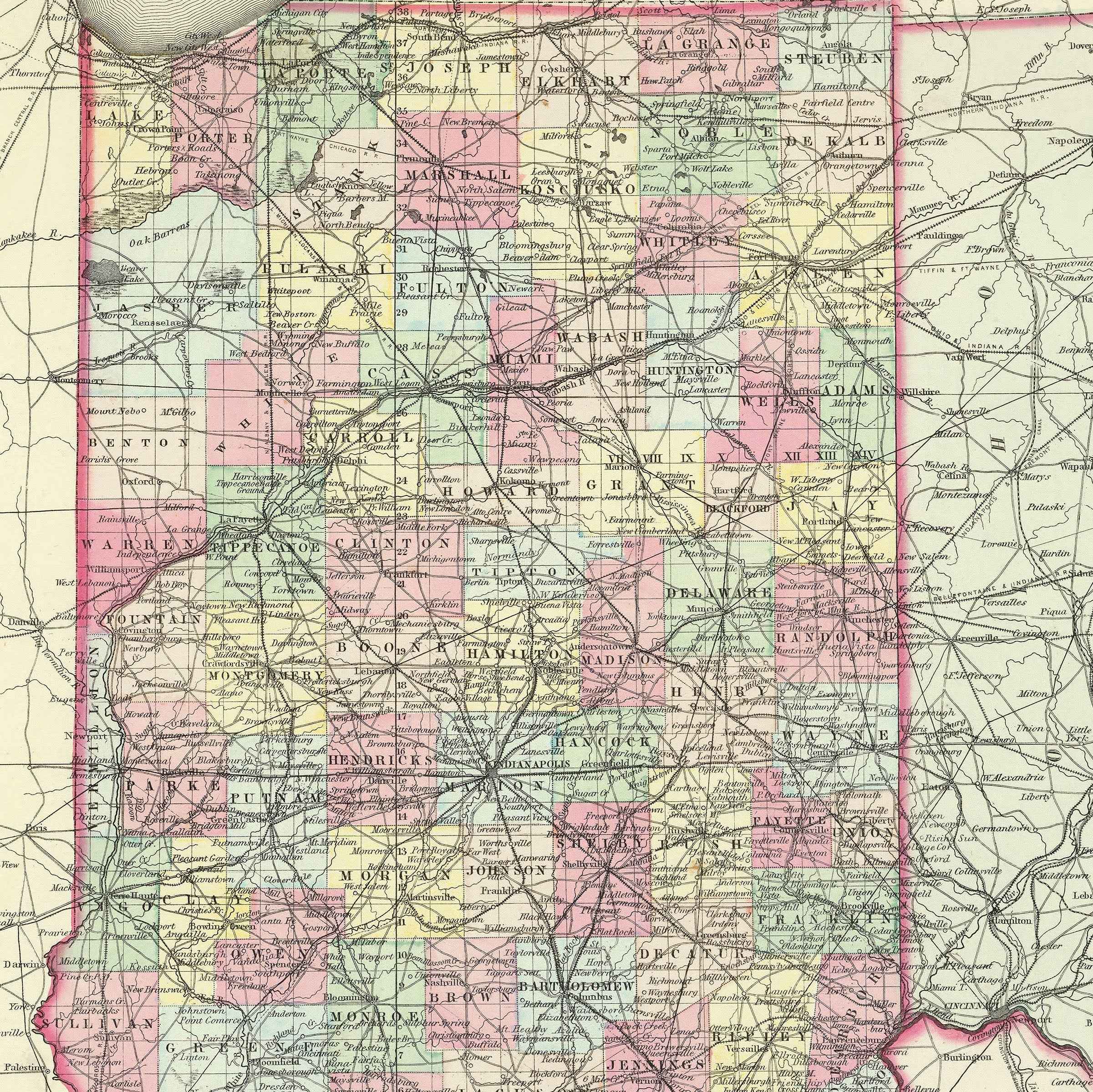
Colton’s 1856 map of Indiana presents a state at the threshold of transformation. Counties are neatly divided, rivers coil across the land, and railroads trace new lines of ambition where, only decades earlier, dense forests and frontier trails held sway. The engraved border frames more than geography—it captures a state becoming the very crossroad its motto would one day claim.
It is 1856, and Franklin Pierce is president. The Kansas–Nebraska Act has split the nation, violence spills westward, and politics sharpen in every town square. Indiana, settled firmly in the Union but neighbor to contested ground, feels the heat of the national debate. This is the soil that would soon nourish Abraham Lincoln’s rise, where Hoosiers argued fiercely in print and pulpit about the future of slavery and the Union itself.
Life in Indiana still runs on agriculture. Corn and hogs fill barns, wheat fields ripple across the prairie, and the Ohio River moves the bounty southward. Yet the map reveals more: railroads radiating from Indianapolis, foreshadowing its destiny as the “Crossroads of America.” Steamboats whistle along the Wabash and the Ohio, while towns like Fort Wayne, Terre Haute, and Evansville grow into bustling centers, binding the state to both Great Lakes and Mississippi trade.
Immigrants from Germany and Ireland add new languages to streets and schools, building breweries, churches, and neighborhoods that blend with older farmsteads. Families who once carved cabins from timber now send sons to work the rails, daughters to classrooms and churches rising in county seats. Local presses debate politics, while telegraph wires string across the land, shrinking distance and speeding news.
Colton’s Indiana is orderly on the page, but in reality it was a place in motion. Wagons still bumped along muddy roads, but iron tracks promised new speed. Forest clearings widened into farms, towns swelled with commerce, and the state’s young capital gathered energy as both political center and rail hub.
Hold the map at arm’s length and it becomes a portrait of transition: Indiana poised between frontier and heartland, its rivers and rails stitching together a people ready to carry the burdens of a divided nation. The engraved lines capture not just land but a restless energy, a state claiming its place at the center of America’s story.
Materials
Hand‑Stretched Canvas: If you choose canvas, we use a premium cotton‑poly blend stretched over solid pine frames. Each canvas is carefully hand‑stretched for a tight, gallery‑quality finish that’s ready to hang right out of the box.
Vivid, Fade‑Resistant Inks: We use professional‑grade inks that are UV‑resistant, so your print retains its rich colors even when displayed in bright rooms.
Expert Restoration: Every map is digitally restored by skilled artisans. We preserve the character of the original while enhancing clarity, so you see the map as it was meant to be seen.
Secure Packaging: Paper prints are rolled in heavy‑duty mailing tubes, and canvases are cushioned in reinforced boxes to ensure they arrive in pristine condition.
Choosing one of our prints means investing in craftsmanship. We combine historical authenticity with modern print technology and premium materials, giving you a work of art built to stand the test of time.
Choose options

Because every place has a story
Make History Personal
A vintage map is more than art.
It is a reminder of where life began.
Where memories were made.
Where hearts still live. Give the gift of place.
Beautifully preserved and made for the moments that matter.
Why Choose Us?
| Feature | Us | Competitor A | Competitor B |
|---|---|---|---|
| Hand Crafted | |||
| Museum Quality | |||
| 100 Year Guarantee | |||
| Restored by Hand | |||
| Certificate of Authenticity |

Art Prints
Archival quality colors. Best option if you'd like to frame it yourself

The Best Materials
We hand-stretched our canvas on solid American-grown pine stretcher bars. We use quality canvas and fade-resistant inks to create the lasting art. Canvases come with hardware already installed and ready to hang.
Need help?
Frequently Asked Questions
Order
All of our maps are meticulously restored reproductions of historic originals. Each piece is digitally repaired and color-corrected to bring out the finest details while preserving its authentic, vintage character.
Yes. All Archive Prints products are printed to order in the USA with archival materials.
We offer two premium formats:
- High-Quality Paper Posters – Printed on thick, archival-grade matte paper for rich, vibrant detail.
- Hand-Stretched Canvas Prints – Printed on premium polycotton canvas and mounted on 1.5" solid American pine stretcher bars for a gallery-quality finish.
We carefully digitally restore each map to enhance clarity and color while preserving its original look and historic charm. You’ll enjoy sharp details and a timeless vintage aesthetic that feels true to the original piece.
Yes, we do! We offer premium framing options to make your map ready to hang the moment it arrives. You can choose from Oak, Maple, Black, or Walnut frames directly on the product page. We also offer Stretched Canvas prints for a modern gallery look, as well as archival-quality Posters if you prefer to frame it yourself.
Yes! We offer free shipping on all products within the United States. Each map is carefully packaged to ensure it arrives in perfect condition.
If you’re not completely satisfied, you can return your order in new condition for a full refund. Return shipping costs are the responsibility of the customer.
Absolutely! Our maps make thoughtful, one-of-a-kind gifts for history lovers, map collectors, or anyone looking to add vintage character to their home or office. Choose between paper prints for framing or stretched canvas for a ready-to-hang presentation.
- Paper Posters → Shipped in durable, protective tubes to prevent creasing.
- Canvas Prints → Carefully wrapped, padded, and boxed to ensure safe delivery.
Our maps look stunning in a variety of settings, including:
- Living rooms and home offices
- Libraries and studies
- Corporate offices and conference rooms
- Restaurants, cafes, and boutique spaces