1867 Nebraska Map - Restored Vintage Wall Art Print for Home Décor
Nebraska Map
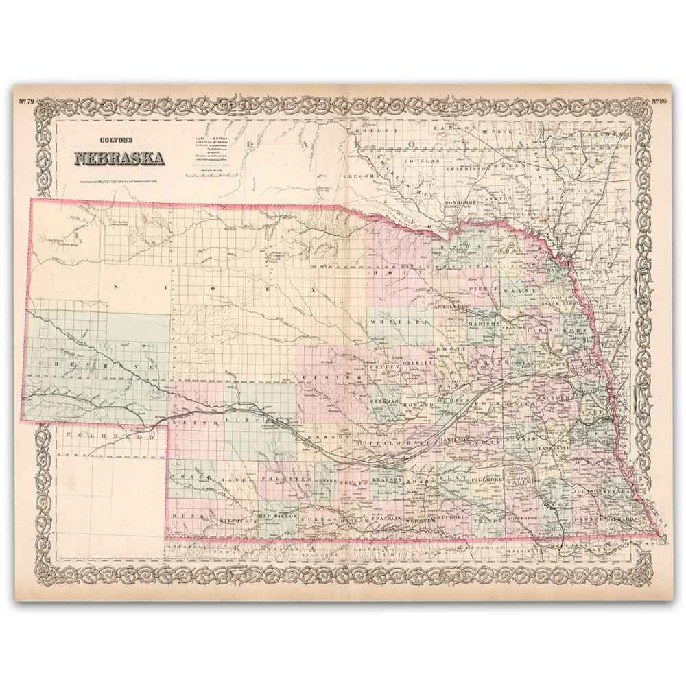
Step back into the late 1860s and see Nebraska as it once was with this beautifully restored Colton Map of Nebraska. Created by J. H. Colton & Co. and issued around 1867, the year of statehood, this historic map captures a young Nebraska taking shape. Pastel county colors, the iconic Colton scrollwork border, and the Union Pacific route along the Platte trace a state moving from frontier to future.
Each reproduction includes a custom historical letter that tells the story behind the map, making it a meaningful gift for collectors, history lovers, and anyone who appreciates Great Plains heritage. Printed on heavyweight archival paper or premium polycotton canvas, every county line, river, rail, and place name is preserved in ultra high definition thanks to meticulous digital restoration.
To ensure your map arrives safely, paper prints are carefully rolled in a sturdy cardboard mailing tube. Canvas prints are stretched on solid pine bars and ship in reinforced boxes for maximum protection. From presentation to preservation, every detail is crafted with care.
Bring home more than wall art. Bring home a story, a conversation piece, and a striking centerpiece that celebrates Nebraska’s enduring landscape and the bold spirit of its earliest statehood years.
The Map Story
Colton’s map of Nebraska captures a young place on the edge of definition. Pastel counties stack across the prairie, the ornate border curls like a theater curtain, and the Platte River cuts its long course from west to east. You can almost feel motion in the lines, as if the page itself is breathing with new arrivals, wagons, and trains.
The year is 1867. Andrew Johnson is president, Reconstruction occupies Washington, and far from the coastal arguments Nebraska steps into the Union as the thirty seventh state. Statehood arrives with practical questions. Where will the capital stand. How will counties be drawn. Who will lay the rails and who will farm the miles of grass that roll to every horizon.
Along the Platte, the answer to one question thunders by on iron wheels. Crews of the Union Pacific drive track across the valley, and depots begin to become towns. Telegraph poles follow, linking sod houses to distant cities. Omaha hustles as a river port and rail hub, while a small village called Lancaster is renamed Lincoln and chosen as the new capital, a decision that pulls power south and west and plants a civic anchor in open country.
The Homestead Act is the quiet engine of this moment. Families stake 160 acre claims, break sod with walking plows, and build homes from the earth beneath their feet. The prairie is both obstacle and blessing. Winds rattle the walls, winter presses in hard, and distance makes neighbors priceless. Yet soil turns to wheat and corn, and a school or church rises wherever a handful of claims can gather a congregation.
Long before section lines, this land belonged to nations who still live in its story. Pawnee camps mark old river bends. Omaha and Otoe trails cross the uplands. Ponca and Lakota hunters follow bison, while Army posts watch the trails and hire Native scouts who know every draw and ford. Treaties shrink homelands to reservations, a reality the map hints at but does not speak aloud.
Commerce learns the new state quickly. Freight wagons carry goods from the steamboat landings, then yield to the railroad. Blacksmith shops, mills, and newspapers appear in town squares. A county fair is enough to pull every family from miles around, the dusty roads suddenly bright with laughter, horses, and pies.
Colton’s map gives all this the look of permanence. Counties are rectangles, rivers dependable, the future neat. Yet the true story is motion. Nebraska in 1867 is a promise made in ink and lived in weather, grit, and hope. To trace its lines is to watch a frontier become a state and to see how ordinary work can reshape a vast and patient land.
Materials
Hand‑Stretched Canvas: If you choose canvas, we use a premium cotton‑poly blend stretched over solid pine frames. Each canvas is carefully hand‑stretched for a tight, gallery‑quality finish that’s ready to hang right out of the box.
Vivid, Fade‑Resistant Inks: We use professional‑grade inks that are UV‑resistant, so your print retains its rich colors even when displayed in bright rooms.
Expert Restoration: Every map is digitally restored by skilled artisans. We preserve the character of the original while enhancing clarity, so you see the map as it was meant to be seen.
Secure Packaging: Paper prints are rolled in heavy‑duty mailing tubes, and canvases are cushioned in reinforced boxes to ensure they arrive in pristine condition.
Choosing one of our prints means investing in craftsmanship. We combine historical authenticity with modern print technology and premium materials, giving you a work of art built to stand the test of time.
Choose options

Because every place has a story
Make History Personal
A vintage map is more than art.
It is a reminder of where life began.
Where memories were made.
Where hearts still live. Give the gift of place.
Beautifully preserved and made for the moments that matter.
Why Choose Us?
| Feature | Us | Competitor A | Competitor B |
|---|---|---|---|
| Hand Crafted | |||
| Museum Quality | |||
| 100 Year Guarantee | |||
| Restored by Hand | |||
| Certificate of Authenticity |

Art Prints
Archival quality colors. Best option if you'd like to frame it yourself

The Best Materials
We hand-stretched our canvas on solid American-grown pine stretcher bars. We use quality canvas and fade-resistant inks to create the lasting art. Canvases come with hardware already installed and ready to hang.
Need help?
Frequently Asked Questions
Order
All of our maps are meticulously restored reproductions of historic originals. Each piece is digitally repaired and color-corrected to bring out the finest details while preserving its authentic, vintage character.
Yes. All Archive Prints products are printed to order in the USA with archival materials.
We offer two premium formats:
- High-Quality Paper Posters – Printed on thick, archival-grade matte paper for rich, vibrant detail.
- Hand-Stretched Canvas Prints – Printed on premium polycotton canvas and mounted on 1.5" solid American pine stretcher bars for a gallery-quality finish.
We carefully digitally restore each map to enhance clarity and color while preserving its original look and historic charm. You’ll enjoy sharp details and a timeless vintage aesthetic that feels true to the original piece.
Yes, we do! We offer premium framing options to make your map ready to hang the moment it arrives. You can choose from Oak, Maple, Black, or Walnut frames directly on the product page. We also offer Stretched Canvas prints for a modern gallery look, as well as archival-quality Posters if you prefer to frame it yourself.
Yes! We offer free shipping on all products within the United States. Each map is carefully packaged to ensure it arrives in perfect condition.
If you’re not completely satisfied, you can return your order in new condition for a full refund. Return shipping costs are the responsibility of the customer.
Absolutely! Our maps make thoughtful, one-of-a-kind gifts for history lovers, map collectors, or anyone looking to add vintage character to their home or office. Choose between paper prints for framing or stretched canvas for a ready-to-hang presentation.
- Paper Posters → Shipped in durable, protective tubes to prevent creasing.
- Canvas Prints → Carefully wrapped, padded, and boxed to ensure safe delivery.
Our maps look stunning in a variety of settings, including:
- Living rooms and home offices
- Libraries and studies
- Corporate offices and conference rooms
- Restaurants, cafes, and boutique spaces