Phoenix Arizona Map - 1885 Restored Vintage Bird’s-Eye View Wall Art
Phoenix Arizona Map
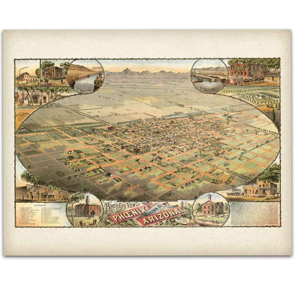
Step back into the 1880s and see the Salt River Valley and Phoenix Arizona Map as early settlers knew it with this beautifully restored 1885 Bird’s-Eye View of Phoenix, Arizona. Published at a moment when the young city was rising from irrigated desert into a thriving town, this panoramic map captures farms, orchards, canal lines, and the compact street grid against distant mountains—an intimate portrait of a community on the verge of growth.
Each reproduction includes a custom historical letter that tells the story behind the view, making it a meaningful gift for collectors, history lovers, and anyone who treasures the heritage of the American Southwest. Printed on heavyweight archival paper or premium poly-cotton canvas, every label, vignette, and rooftop is preserved in ultra-high-definition clarity thanks to meticulous digital restoration.
To ensure your piece arrives safely, paper prints are carefully rolled in a sturdy cardboard mailing tube, while canvases are stretched on solid pine bars and ship in reinforced boxes for maximum protection. From presentation to preservation, every detail is crafted with care.
Bring home more than wall art. Bring home a story, a conversation piece, and a striking centerpiece that celebrates Phoenix’s frontier beginnings—fields and canals stitched into a desert plain, main streets taking shape, and the promise of a modern city just ahead.
Printed in the USA on heavyweight archival paper or poly-cotton canvas.
The Map Story
The bird’s-eye view shows a young town stitched into a desert plain: neat streets, square fields, and pale canals glinting under a wide sky. Beyond the tidy grid, mountains ring the valley like a low crown—familiar silhouettes that make the town seem both protected and very small. From this height you can almost hear the creak of wagons and the scrape of shovels as Phoenix wills itself into being.
It is 1885. Grover Cleveland has just entered the White House, the first Democrat to win since the war. Arizona is still a territory, its capital up the road in Prescott, its future statehood a distant promise. The Salt River Valley is the territory’s quiet gamble. Settlers have followed ancient Hohokam traces, opening ditches along ghost channels to coax green out of brown. The Arizona Canal is finishing this very year, throwing water farther across the plain than anyone thought possible. Farms of barley, alfalfa, and citrus take hold. Orchards throw shade. In the mornings, teams clatter across wooden bridges and the smell of irrigated earth tells everyone the valley is changing.
Phoenix itself is barely four years into cityhood. The railroad has not yet reached town; that will come in 1887. For now, passengers and freight jump off at Maricopa and jolt north by stage, dreaming of the day iron will replace dust. Merchants on Washington Street haggle over prices pulled from faraway markets. A newspaper presses type by lamplight. In Tempe, the Territorial Normal School has just opened its doors, training teachers for schools that rise wherever a few dozen families settle. Down in Tucson, the new territorial university signals ambitions that run ahead of population. Across the south, copper and silver mines throw off feverish booms and sober busts; Tombstone is already a story everyone tells with a grin or a wince.
Not all change is triumph. The U.S. Army still patrols the high country as the long conflict with the Apache smolders toward its end. Reservations draw hard new lines across older homelands. The territory’s newspapers argue over funding, law, and the location of institutions—politics as prickly as the cholla but necessary for a place trying to become more than a string of camps.
Back in the valley, evening settles. Water hums along ditch banks. A wind lifts the dust off Main Street and carries it toward fields that were desert a season ago. The map records buildings, roads, and little circular vignettes of churches and hotels, but what it really captures is a mood: audacity tempered by scarcity, optimism held together with rope and will. Phoenix is not yet the capital, not yet a metropolis, but it is certain of its direction. Follow the canals and you follow the future—straight across a dry land made livable by patience, engineering, and the stubborn belief that a city can be drawn first on paper, then in water, and finally in stone.
Materials
Hand‑Stretched Canvas: If you choose canvas, we use a premium cotton‑poly blend stretched over solid pine frames. Each canvas is carefully hand‑stretched for a tight, gallery‑quality finish that’s ready to hang right out of the box.
Vivid, Fade‑Resistant Inks: We use professional‑grade inks that are UV‑resistant, so your print retains its rich colors even when displayed in bright rooms.
Expert Restoration: Every map is digitally restored by skilled artisans. We preserve the character of the original while enhancing clarity, so you see the map as it was meant to be seen.
Secure Packaging: Paper prints are rolled in heavy‑duty mailing tubes, and canvases are cushioned in reinforced boxes to ensure they arrive in pristine condition.
Choosing one of our prints means investing in craftsmanship. We combine historical authenticity with modern print technology and premium materials, giving you a work of art built to stand the test of time.
Choose options

Because every place has a story
Make History Personal
A vintage map is more than art.
It is a reminder of where life began.
Where memories were made.
Where hearts still live. Give the gift of place.
Beautifully preserved and made for the moments that matter.
Why Choose Us?
| Feature | Us | Competitor A | Competitor B |
|---|---|---|---|
| Hand Crafted | |||
| Museum Quality | |||
| 100 Year Guarantee | |||
| Restored by Hand | |||
| Certificate of Authenticity |

Art Prints
Archival quality colors. Best option if you'd like to frame it yourself

The Best Materials
We hand-stretched our canvas on solid American-grown pine stretcher bars. We use quality canvas and fade-resistant inks to create the lasting art. Canvases come with hardware already installed and ready to hang.
Need help?
Frequently Asked Questions
Order
All of our maps are meticulously restored reproductions of historic originals. Each piece is digitally repaired and color-corrected to bring out the finest details while preserving its authentic, vintage character.
Yes. All Archive Prints products are printed to order in the USA with archival materials.
We offer two premium formats:
- High-Quality Paper Posters – Printed on thick, archival-grade matte paper for rich, vibrant detail.
- Hand-Stretched Canvas Prints – Printed on premium polycotton canvas and mounted on 1.5" solid American pine stretcher bars for a gallery-quality finish.
We carefully digitally restore each map to enhance clarity and color while preserving its original look and historic charm. You’ll enjoy sharp details and a timeless vintage aesthetic that feels true to the original piece.
Yes, we do! We offer premium framing options to make your map ready to hang the moment it arrives. You can choose from Oak, Maple, Black, or Walnut frames directly on the product page. We also offer Stretched Canvas prints for a modern gallery look, as well as archival-quality Posters if you prefer to frame it yourself.
Yes! We offer free shipping on all products within the United States. Each map is carefully packaged to ensure it arrives in perfect condition.
If you’re not completely satisfied, you can return your order in new condition for a full refund. Return shipping costs are the responsibility of the customer.
Absolutely! Our maps make thoughtful, one-of-a-kind gifts for history lovers, map collectors, or anyone looking to add vintage character to their home or office. Choose between paper prints for framing or stretched canvas for a ready-to-hang presentation.
- Paper Posters → Shipped in durable, protective tubes to prevent creasing.
- Canvas Prints → Carefully wrapped, padded, and boxed to ensure safe delivery.
Our maps look stunning in a variety of settings, including:
- Living rooms and home offices
- Libraries and studies
- Corporate offices and conference rooms
- Restaurants, cafes, and boutique spaces