1889 Key West Map - Florida Bird’s-Eye View Vintage Map (Restored)
Key West Map
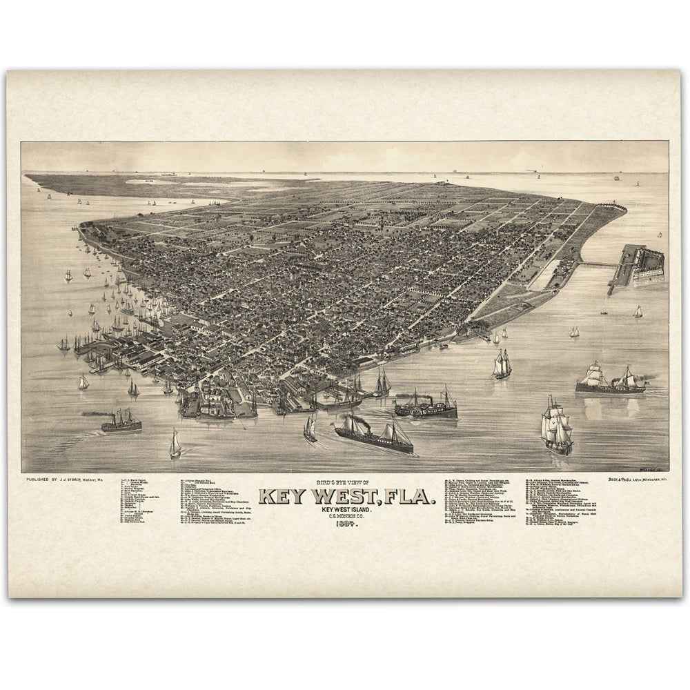
Step back to the late 19th century Key West Map with this beautifully restored 1889 Bird’s-Eye View of Key West, Florida. Drawn from an elevated perspective, the city spreads across the island in remarkable detail—busy wharves, schooners and steamers crowding the harbor, the lighthouse standing watch, and neat streets lined with homes and cigar factories. It’s a vivid portrait of Key West at the height of its maritime era.
Each reproduction includes a custom historical letter that tells the story behind the map, making it a perfect gift for collectors, cartography fans, and anyone who loves Florida’s coastal heritage. Printed on heavyweight archival paper or premium poly-cotton canvas, every rooftop, vessel, and shoreline is preserved in ultra-high-definition clarity thanks to meticulous digital restoration—the warm vintage tone intact, the linework crisp.
For protection and presentation, every detail is crafted with care. Paper prints are carefully rolled in a sturdy cardboard mailing tube for safe arrival and easy framing in standard sizes. Canvas prints are gallery-wrapped on solid 1.5″ pine stretcher bars and ship in reinforced boxes—ready to hang right out of the box with a pre-installed sawtooth hanger.
Bring home more than wall art. Bring home a story, a conversation piece, and a striking centerpiece that celebrates Key West’s islands, harbor life, and timeless tropical charm.
The Map Story
The bird’s-eye view tilts the island like a tray lifted from the sea—streets ruled straight, docks spiked into the water, schooners and steamers drifting like seeds on a tide. Houses crowd the shore on tall limestone foundations, roofs angled for trade winds, shutters half-closed against the glare. From this height the lighthouse is a fixed flame and the reef beyond a pale, serrated ribbon. The map holds everything still, but Key West in 1889 is always moving.
Benjamin Harrison is the new president in Washington. Florida, far to the south and west of most politics, keeps its attention on ships and weather. Jacksonville is recovering from a brutal fever season; Tampa rushes toward growth under new rails and cigar capital. Key West stands between: a city of coral rock and wooden porches, closer to Havana than to Miami, living by the sea’s mercy and promise.
Three years earlier fire wrecked the town, but the island builds fast. Conch carpenters raise airy houses from Dade County pine; wharves are widened and braced; factories hum again. The cigar trade still drives the day—rollers at long tables reading news and novels aloud while hands twist leaf into heat and perfume. Yet the future is tugging elsewhere; owners court Tampa’s cheaper land and rail connections, and some workshops quietly follow the tide of investment north. Even so, morning streets fill with workers, and the harbor keeps its voice—lines slapping masts, winches rattle, a tug coughs to life.
Cuba is the half-seen room in every conversation. Exiles debate in cafés, papers pass from hand to hand, and money slips into envelopes bound across the Florida Straits. Fishing boats return with decks glittering from the sponge fields; turtle kraals darken with shells; wreckers—fewer now, thwarted by lighthouses—still watch the reef for luck and disaster. The Navy’s presence steadies the waterfront; uniforms share pier space with cigar bales and barrels of limes.
Afternoons, heat lies heavy over the flats. Children balance on pilings, casting for snapper; a woman sweeps her stoop as a procession of sailors ambles past; bells ring from St. Mary’s and the sound runs down Caroline Street like water. After sunset the island exhales. Music slips from open windows, Cuban and Bahamian rhythms braided with hymns and waltzes. Lanterns mark the lane behind the cigar works; a late steamer slides in from Havana, its lamps doubled in the harbor.
The map’s legend lists churches, schools, and factories as if a place could be summed in numbers. But Key West’s count is different: storms survived, voyages finished, stories told on verandas where neighbors lean close in the evening breeze. In 1889 the city is rebuilding, arguing, exporting, dreaming—its future uncertain but its center unmistakable. Stand at the edge of the pier and look where the chart shows only depth soundings: that is the road out, the road back, the reason a small island feels as large as the sea that surrounds it.
Materials
Hand‑Stretched Canvas: If you choose canvas, we use a premium cotton‑poly blend stretched over solid pine frames. Each canvas is carefully hand‑stretched for a tight, gallery‑quality finish that’s ready to hang right out of the box.
Vivid, Fade‑Resistant Inks: We use professional‑grade inks that are UV‑resistant, so your print retains its rich colors even when displayed in bright rooms.
Expert Restoration: Every map is digitally restored by skilled artisans. We preserve the character of the original while enhancing clarity, so you see the map as it was meant to be seen.
Secure Packaging: Paper prints are rolled in heavy‑duty mailing tubes, and canvases are cushioned in reinforced boxes to ensure they arrive in pristine condition.
Choosing one of our prints means investing in craftsmanship. We combine historical authenticity with modern print technology and premium materials, giving you a work of art built to stand the test of time.
Choose options

Because every place has a story
Make History Personal
A vintage map is more than art.
It is a reminder of where life began.
Where memories were made.
Where hearts still live. Give the gift of place.
Beautifully preserved and made for the moments that matter.
Why Choose Us?
| Feature | Us | Competitor A | Competitor B |
|---|---|---|---|
| Hand Crafted | |||
| Museum Quality | |||
| 100 Year Guarantee | |||
| Restored by Hand | |||
| Certificate of Authenticity |

Art Prints
Archival quality colors. Best option if you'd like to frame it yourself

The Best Materials
We hand-stretched our canvas on solid American-grown pine stretcher bars. We use quality canvas and fade-resistant inks to create the lasting art. Canvases come with hardware already installed and ready to hang.
Need help?
Frequently Asked Questions
Order
All of our maps are meticulously restored reproductions of historic originals. Each piece is digitally repaired and color-corrected to bring out the finest details while preserving its authentic, vintage character.
Yes. All Archive Prints products are printed to order in the USA with archival materials.
We offer two premium formats:
- High-Quality Paper Posters – Printed on thick, archival-grade matte paper for rich, vibrant detail.
- Hand-Stretched Canvas Prints – Printed on premium polycotton canvas and mounted on 1.5" solid American pine stretcher bars for a gallery-quality finish.
We carefully digitally restore each map to enhance clarity and color while preserving its original look and historic charm. You’ll enjoy sharp details and a timeless vintage aesthetic that feels true to the original piece.
Yes, we do! We offer premium framing options to make your map ready to hang the moment it arrives. You can choose from Oak, Maple, Black, or Walnut frames directly on the product page. We also offer Stretched Canvas prints for a modern gallery look, as well as archival-quality Posters if you prefer to frame it yourself.
Yes! We offer free shipping on all products within the United States. Each map is carefully packaged to ensure it arrives in perfect condition.
If you’re not completely satisfied, you can return your order in new condition for a full refund. Return shipping costs are the responsibility of the customer.
Absolutely! Our maps make thoughtful, one-of-a-kind gifts for history lovers, map collectors, or anyone looking to add vintage character to their home or office. Choose between paper prints for framing or stretched canvas for a ready-to-hang presentation.
- Paper Posters → Shipped in durable, protective tubes to prevent creasing.
- Canvas Prints → Carefully wrapped, padded, and boxed to ensure safe delivery.
Our maps look stunning in a variety of settings, including:
- Living rooms and home offices
- Libraries and studies
- Corporate offices and conference rooms
- Restaurants, cafes, and boutique spaces