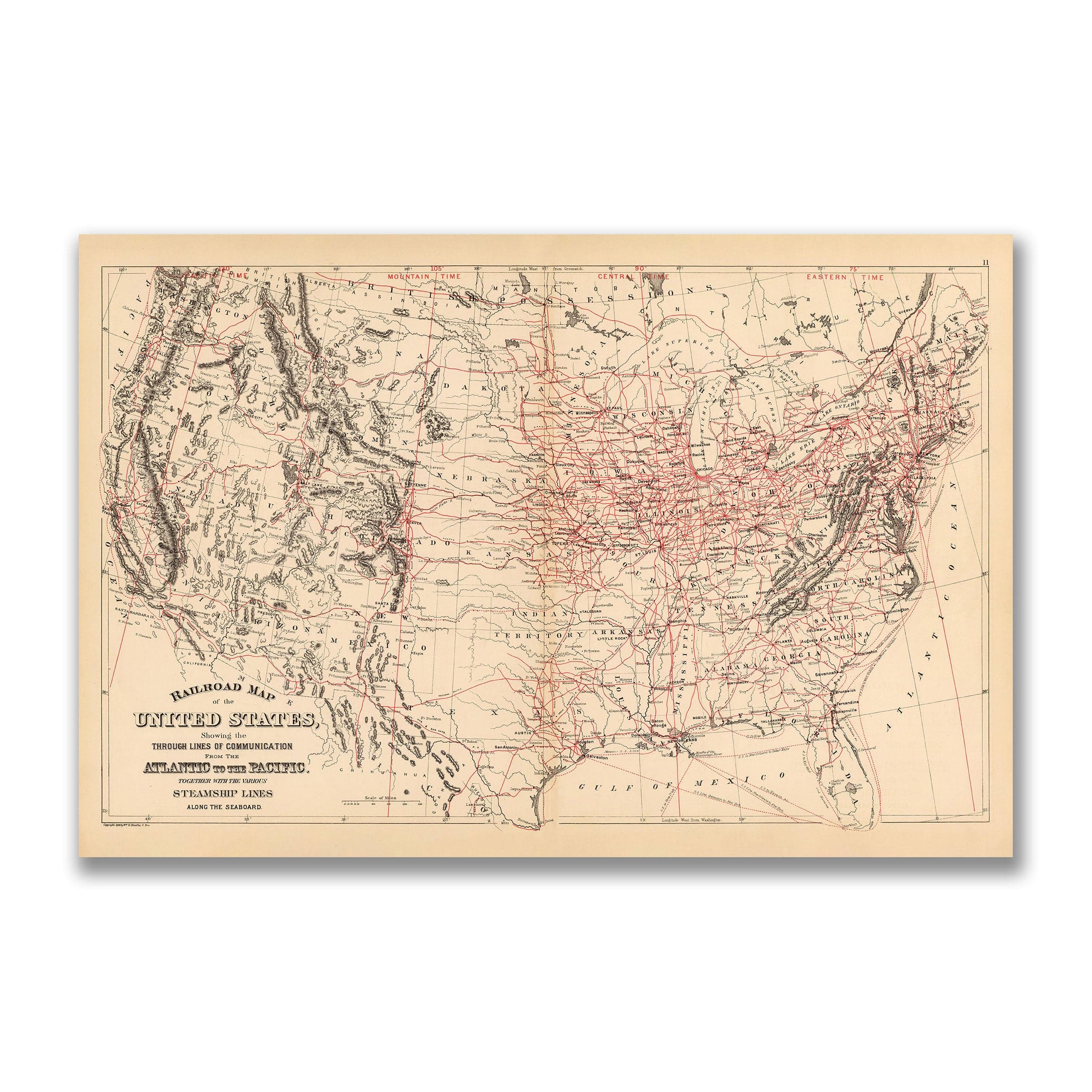
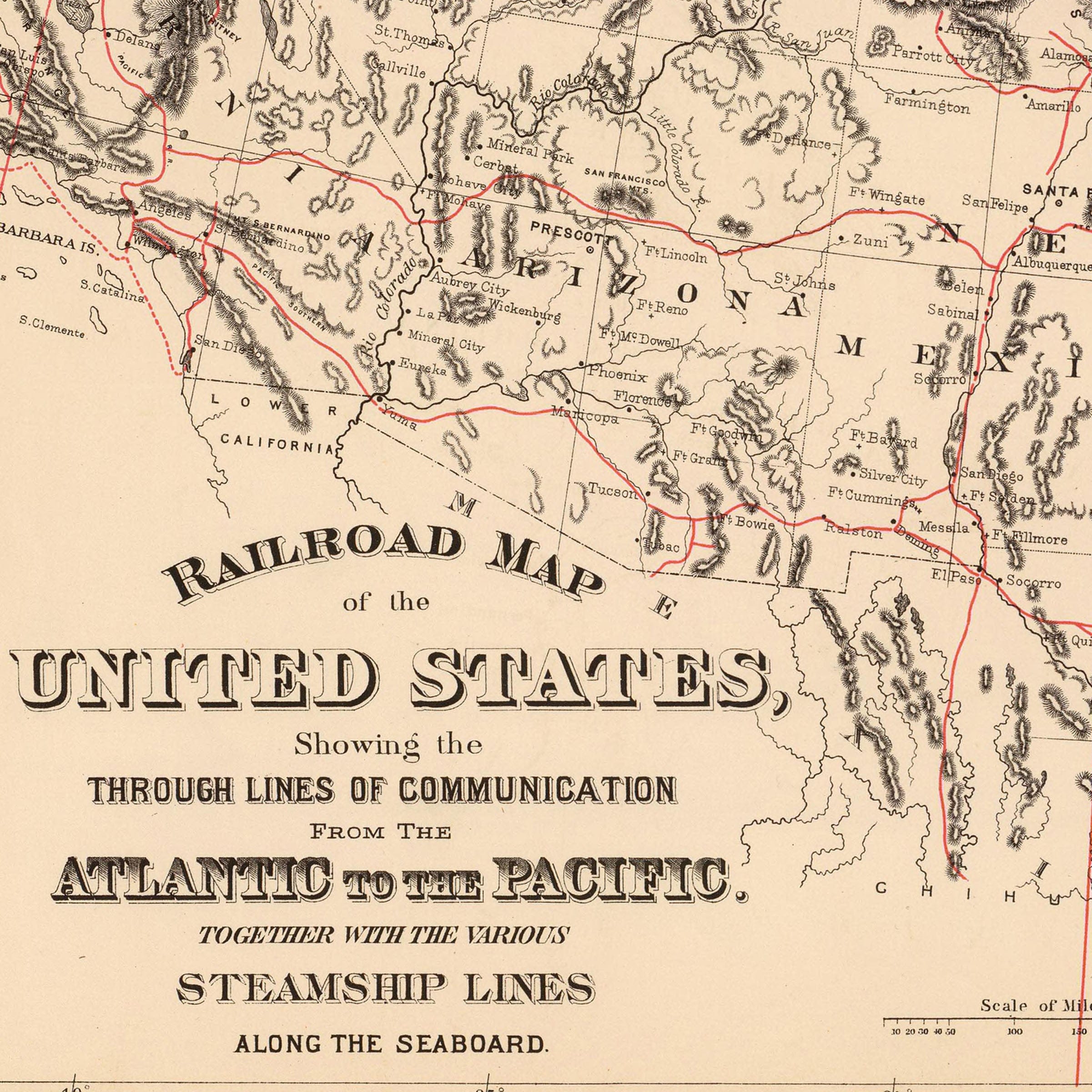

1890 Railroad Map of the US
1890 Railroad Map of the US
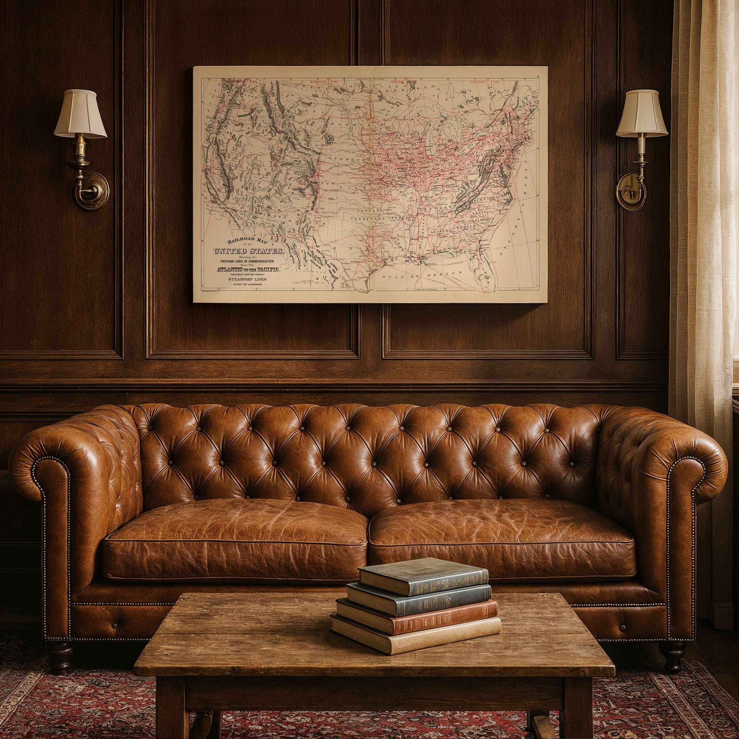
Discover the remarkable 1890 Railroad Map of the US by Samuel Augustus Mitchell, capturing America in the full surge of its industrial age—a nation transformed by iron, steam, and ambition. Published by John Y. Huber & Co. of Philadelphia and engraved by Wm. M. Bradley & Bros., this map vividly illustrates the vast network of rail lines that bound the continent together, from the crowded eastern seaboard to the distant reaches of California and the Pacific coast. This isn't just a map—it's a portrait of American progress and the iron arteries that united a nation.
Every red line across this 1890 Railroad Map of the US represents more than steel and timber; it marks progress, migration, and opportunity. By 1890, railroads were not merely a mode of transportation—they were the veins of commerce and civilization itself. They carried the nation's raw materials, its goods, and its people, shrinking distances and uniting regions once thought unreachable. Steamships, drawn along the coasts, completed the picture of a country now seamlessly connected to the wider world through an intricate web of rail and maritime transportation.
The 1890 Railroad Map of the US reflects both artistry and precision in Samuel Augustus Mitchell's renowned cartographic style. Relief is shown by delicate hachures, rivers and settlements are carefully labeled, and the great mountain ranges stand as natural counterpoints to the engineered might of the railroads. The introduction of time zones—Eastern, Central, and Mountain—appears neatly across the top, a fascinating detail that reveals how the railroads themselves had standardized timekeeping across the United States only a few years earlier, fundamentally reshaping American daily life.
This 1890 Railroad Map of the US embodies the optimism and confidence of the late 19th century. The Industrial Revolution had given America new tools, and the railroad made the country's vast resources accessible to all who dared to reach for them. Towns that were once isolated outposts had become bustling junctions; trade, communication, and migration now flowed with unprecedented speed. The map captures this transformative moment when the American West opened to settlement and commerce on an unprecedented scale.
Perfect for railroad enthusiasts, American history collectors, and lovers of industrial heritage, this 1890 Railroad Map of the US reproduction includes a custom historical certificate detailing the story behind Mitchell's iconic cartography. To hold this map is to see a nation in motion—a place where the journey west was no longer perilous, but inevitable. Printed on heavyweight archival paper or hand-stretched polycotton canvas, every rail line, mountain range, and settlement is restored in museum-grade clarity for generations of enjoyment. Paper prints ship rolled in heavy-duty tubes, while canvas editions arrive gallery-wrapped on solid pine stretcher bars with pre-installed hardware—ready to display the moment it arrives. Bring home a piece of American industrial history and celebrate how steel and steam united a divided nation.
The Map Story
Every red line across the page represents more than steel and timber; it marks progress, migration, and opportunity. By 1890, railroads were not merely a mode of transportation—they were the veins of commerce and civilization itself. They carried the nation's raw materials, its goods, and its people, shrinking distances and uniting regions once thought unreachable. Steamships, drawn along the coasts, completed the picture of a country now seamlessly connected to the wider world.
Mitchell's map reflects both artistry and precision. Relief is shown by delicate hachures, rivers and settlements are carefully labeled, and the great mountain ranges stand as natural counterpoints to the engineered might of the railroads. The introduction of time zones—Eastern, Central, and Mountain—appears neatly across the top, a detail that reveals how the railroads themselves had standardized timekeeping across the United States only a few years earlier.
This map embodies the optimism and confidence of the late 19th century. The Industrial Revolution had given America new tools, and the railroad made the country's vast resources accessible to all who dared to reach for them. Towns that were once isolated outposts had become bustling junctions; trade, communication, and migration now flowed with unprecedented speed.
To hold this 1890 map is to see a nation in motion—a place where the journey west was no longer perilous, but inevitable. It is both a document of geography and a portrait of determination, charting how the United States, once divided by wilderness and distance, became a single connected nation of steel and steam.
Materials
Choose options

Because every place has a story
Make History Personal
A vintage map is more than art.
It is a reminder of where life began.
Where memories were made.
Where hearts still live. Give the gift of place.
Beautifully preserved and made for the moments that matter.
Why Choose Us?
| Feature | Us | Competitor A | Competitor B |
|---|---|---|---|
| Hand Crafted | |||
| Museum Quality | |||
| 100 Year Guarantee | |||
| Restored by Hand | |||
| Certificate of Authenticity |

Art Prints
Archival quality colors. Best option if you'd like to frame it yourself

The Best Materials
We hand-stretched our canvas on solid American-grown pine stretcher bars. We use quality canvas and fade-resistant inks to create the lasting art. Canvases come with hardware already installed and ready to hang.
Need help?
Frequently Asked Questions
Order
All of our maps are meticulously restored reproductions of historic originals. Each piece is digitally repaired and color-corrected to bring out the finest details while preserving its authentic, vintage character.
Yes. All Archive Prints products are printed to order in the USA with archival materials.
We offer two premium formats:
- High-Quality Paper Posters – Printed on thick, archival-grade matte paper for rich, vibrant detail.
- Hand-Stretched Canvas Prints – Printed on premium polycotton canvas and mounted on 1.5" solid American pine stretcher bars for a gallery-quality finish.
We carefully digitally restore each map to enhance clarity and color while preserving its original look and historic charm. You’ll enjoy sharp details and a timeless vintage aesthetic that feels true to the original piece.
Yes, we do! We offer premium framing options to make your map ready to hang the moment it arrives. You can choose from Oak, Maple, Black, or Walnut frames directly on the product page. We also offer Stretched Canvas prints for a modern gallery look, as well as archival-quality Posters if you prefer to frame it yourself.
Yes! We offer free shipping on all products within the United States. Each map is carefully packaged to ensure it arrives in perfect condition.
If you’re not completely satisfied, you can return your order in new condition for a full refund. Return shipping costs are the responsibility of the customer.
Absolutely! Our maps make thoughtful, one-of-a-kind gifts for history lovers, map collectors, or anyone looking to add vintage character to their home or office. Choose between paper prints for framing or stretched canvas for a ready-to-hang presentation.
- Paper Posters → Shipped in durable, protective tubes to prevent creasing.
- Canvas Prints → Carefully wrapped, padded, and boxed to ensure safe delivery.
Our maps look stunning in a variety of settings, including:
- Living rooms and home offices
- Libraries and studies
- Corporate offices and conference rooms
- Restaurants, cafes, and boutique spaces