

Abilene Vintage Map - Authentic 1883 Texas Historical City Map
Discover Abilene's Railroad Heritage
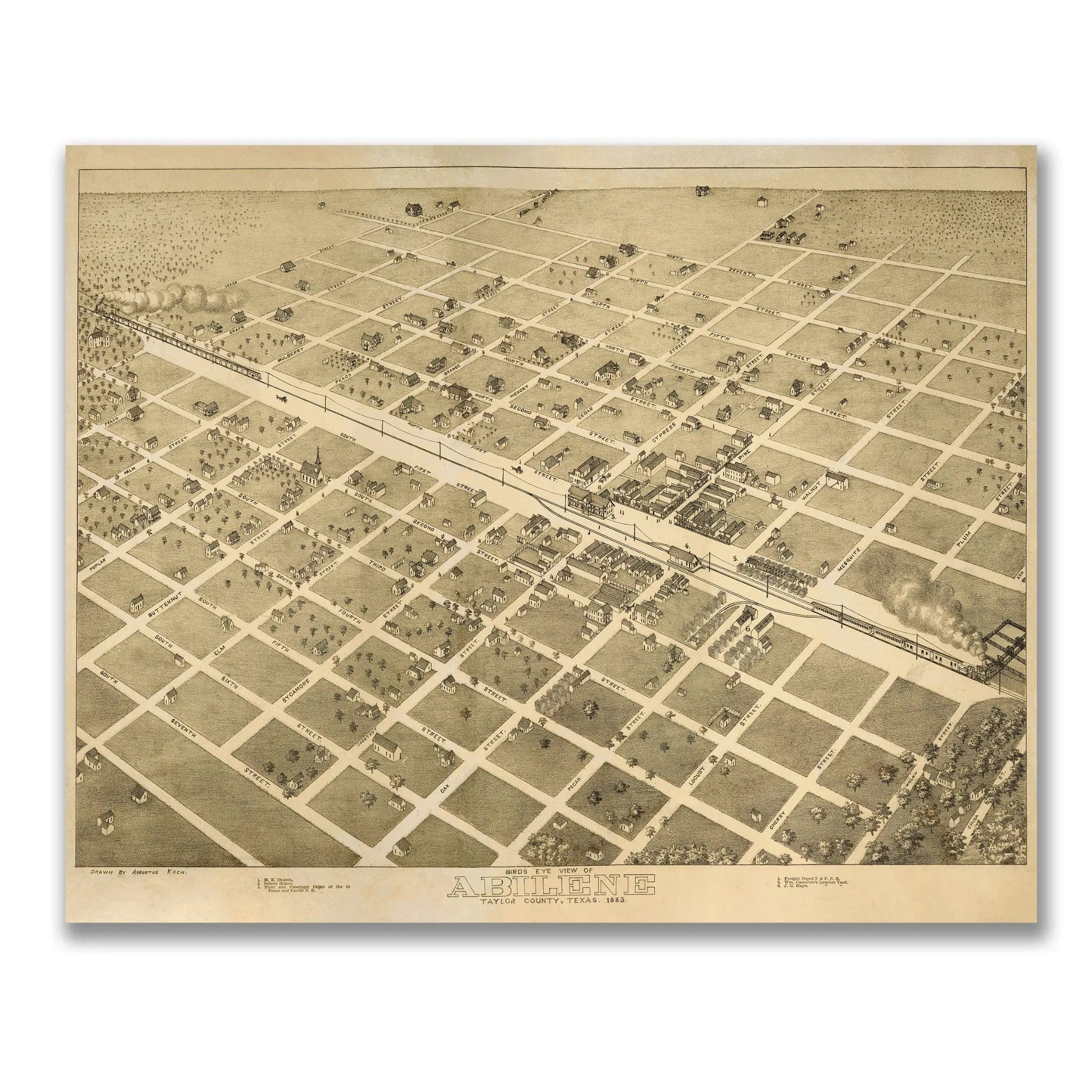
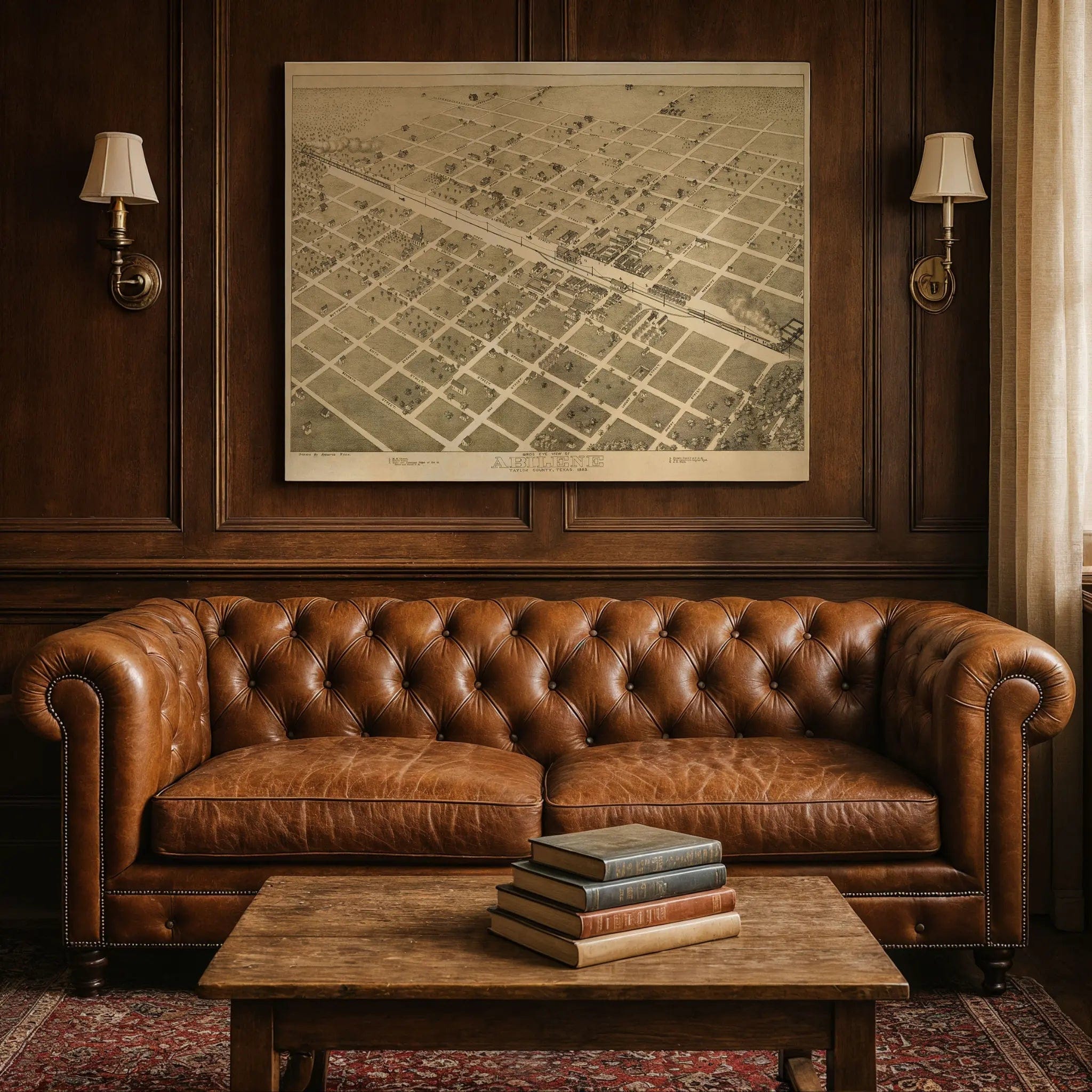
Step back into 1883 Texas with this extraordinary Bird's-Eye View of Abilene, Taylor County by Louis C. Wise & Co. This remarkable panoramic map captures the town during its formative years as a frontier railroad settlement, when the Texas and Pacific Railway transformed a collection of buffalo hunters' camps into one of West Texas's most important cattle shipping centers. Every street, building, and rail line reflects a community built on the promise of the railroad and the endless herds of longhorn cattle that made Abilene synonymous with the American frontier.
Historical Significance
In 1883, Abilene stood at the crossroads of the American West, where the great cattle drives from South Texas met the steel rails that would carry beef to markets across the nation. This meticulously detailed map documents the town during its golden age as a cattle shipping center, when cowboys, railroad workers, and ambitious entrepreneurs created a bustling frontier community on the edge of the Great Plains. The substantial courthouse, hotels, and commercial buildings shown in the map reflect the rapid prosperity that came when the railroad arrived in 1881, transforming Abilene from a collection of dugouts and tents into a thriving county seat.
Cartographic Excellence
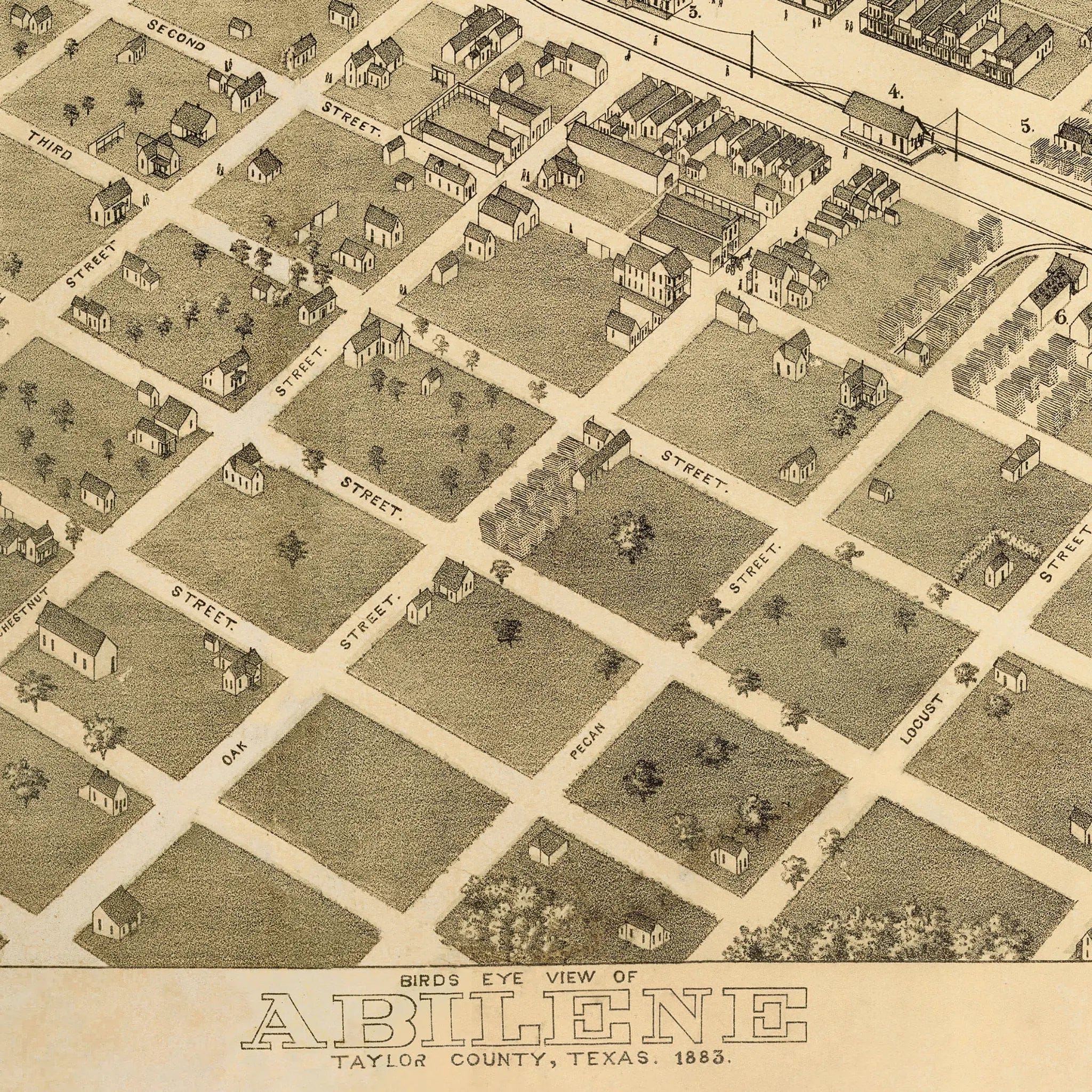
Wise & Co.'s masterful bird's-eye perspective showcases Abilene with remarkable attention to both urban development and frontier character. The neat grid of streets radiates outward from the railroad depot, the beating heart of this frontier economy, while substantial buildings and tree-lined avenues speak to the optimism and civic pride of a community that believed it was destined for greatness. The precise rendering captures the unique character of a Texas railroad town, where the rhythms of cattle drives and train schedules shaped every aspect of community life.
Urban Development Story
The artistry of this map lies in its documentation of a town that perfectly embodied the spirit of the American frontier. Abilene's wide streets and generous lots reflect the foresight of its founders, who understood that a successful cattle town needed room for herds, corrals, and the seasonal rhythms of the cattle trade. The substantial buildings and orderly layout speak to the prosperity that good planning and railroad connections could create, while the surrounding prairie stretches to the horizon, emphasizing the town's role as the last outpost of civilization before the vast emptiness of West Texas.
A Vision of Frontier Progress
This map serves as a portrait of the American frontier dream realized, capturing Abilene when it was the beating heart of the Texas cattle industry. The careful attention to both railroad infrastructure and civic institutions reflects a community that understood its role as the gateway between the ranching frontier and the industrial markets of the East. The balance between frontier practicality and urban ambition shows a town that prospered by serving as the crucial link in the great chain of commerce that connected Texas ranches to dinner tables across America.
A Piece of Texas History
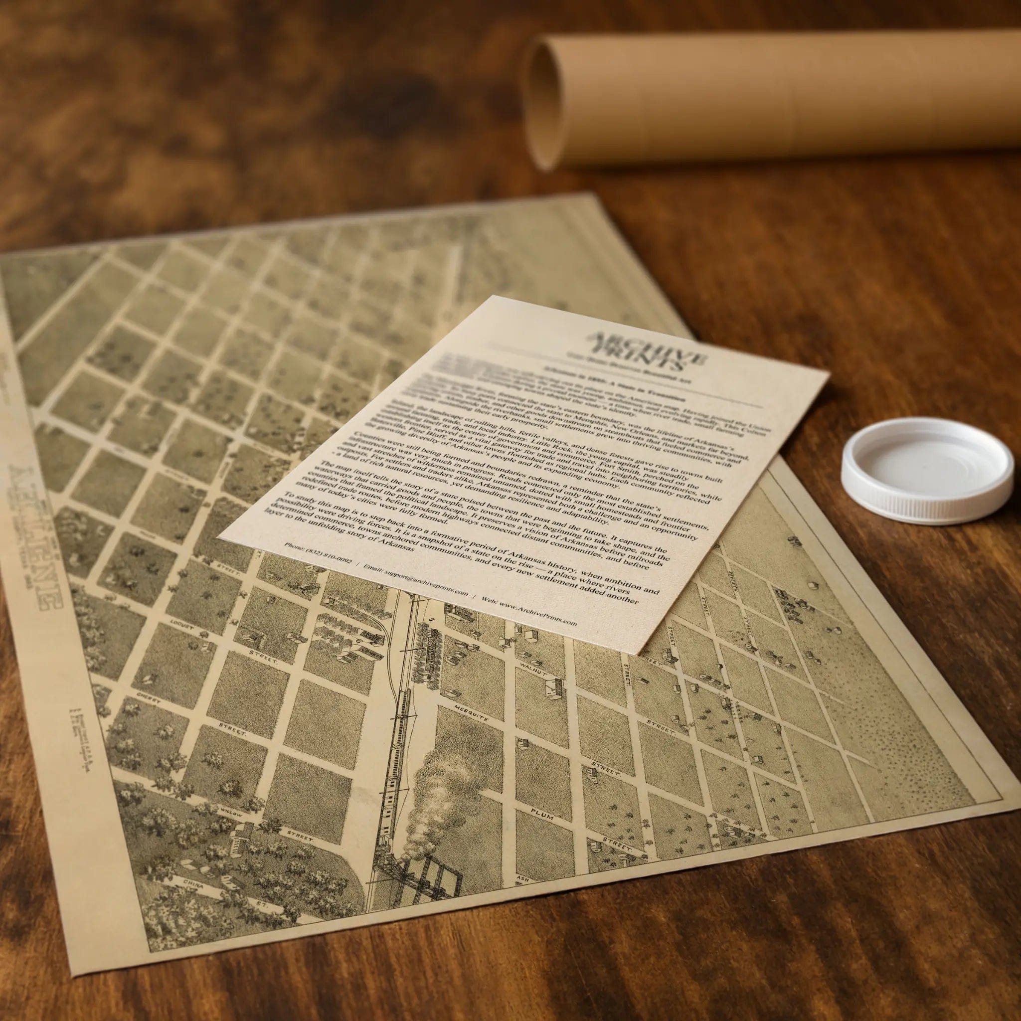
Each restored reproduction of this 1883 map is printed with museum-quality precision on heavyweight archival paper or hand-stretched premium canvas to preserve every original detail. Your purchase includes two companion documents:
Certificate of Authenticity verifying its restoration and reproduction quality
Historical Story Page detailing the origins, craftsmanship, and cultural significance of Wise & Co.'s iconic map
Paper prints arrive rolled in reinforced mailing tubes for protection. Canvas prints come gallery-wrapped on solid pine stretcher bars with pre-installed hardware, ready to display upon arrival.
Bring home a vivid piece of Texas history—a timeless record of Abilene's frontier heritage and the railroad revolution that transformed the American West.
The Map Story
Materials
Choose options

Because every place has a story
Make History Personal
A vintage map is more than art.
It is a reminder of where life began.
Where memories were made.
Where hearts still live. Give the gift of place.
Beautifully preserved and made for the moments that matter.
Why Choose Us?
| Feature | Us | Competitor A | Competitor B |
|---|---|---|---|
| Hand Crafted | |||
| Museum Quality | |||
| 100 Year Guarantee | |||
| Restored by Hand | |||
| Certificate of Authenticity |

Art Prints
Archival quality colors. Best option if you'd like to frame it yourself

The Best Materials
We hand-stretched our canvas on solid American-grown pine stretcher bars. We use quality canvas and fade-resistant inks to create the lasting art. Canvases come with hardware already installed and ready to hang.
Need help?
Frequently Asked Questions
Order
All of our maps are meticulously restored reproductions of historic originals. Each piece is digitally repaired and color-corrected to bring out the finest details while preserving its authentic, vintage character.
Yes. All Archive Prints products are printed to order in the USA with archival materials.
We offer two premium formats:
- High-Quality Paper Posters – Printed on thick, archival-grade matte paper for rich, vibrant detail.
- Hand-Stretched Canvas Prints – Printed on premium polycotton canvas and mounted on 1.5" solid American pine stretcher bars for a gallery-quality finish.
We carefully digitally restore each map to enhance clarity and color while preserving its original look and historic charm. You’ll enjoy sharp details and a timeless vintage aesthetic that feels true to the original piece.
Yes, we do! We offer premium framing options to make your map ready to hang the moment it arrives. You can choose from Oak, Maple, Black, or Walnut frames directly on the product page. We also offer Stretched Canvas prints for a modern gallery look, as well as archival-quality Posters if you prefer to frame it yourself.
Yes! We offer free shipping on all products within the United States. Each map is carefully packaged to ensure it arrives in perfect condition.
If you’re not completely satisfied, you can return your order in new condition for a full refund. Return shipping costs are the responsibility of the customer.
Absolutely! Our maps make thoughtful, one-of-a-kind gifts for history lovers, map collectors, or anyone looking to add vintage character to their home or office. Choose between paper prints for framing or stretched canvas for a ready-to-hang presentation.
- Paper Posters → Shipped in durable, protective tubes to prevent creasing.
- Canvas Prints → Carefully wrapped, padded, and boxed to ensure safe delivery.
Our maps look stunning in a variety of settings, including:
- Living rooms and home offices
- Libraries and studies
- Corporate offices and conference rooms
- Restaurants, cafes, and boutique spaces