


Alexandria, Virginia Map - 1863 Bird's Eye View
Alexandria, Virginia Map
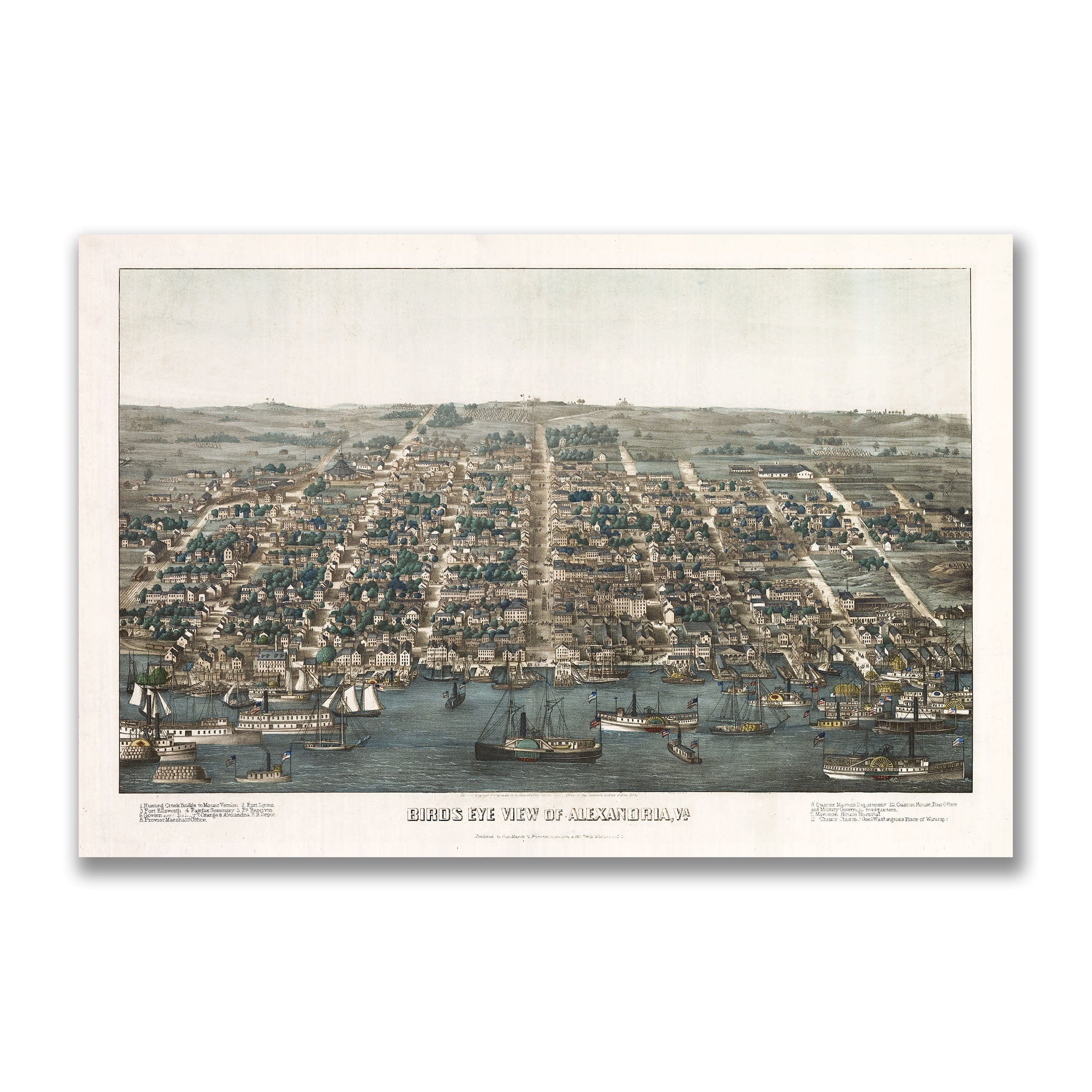
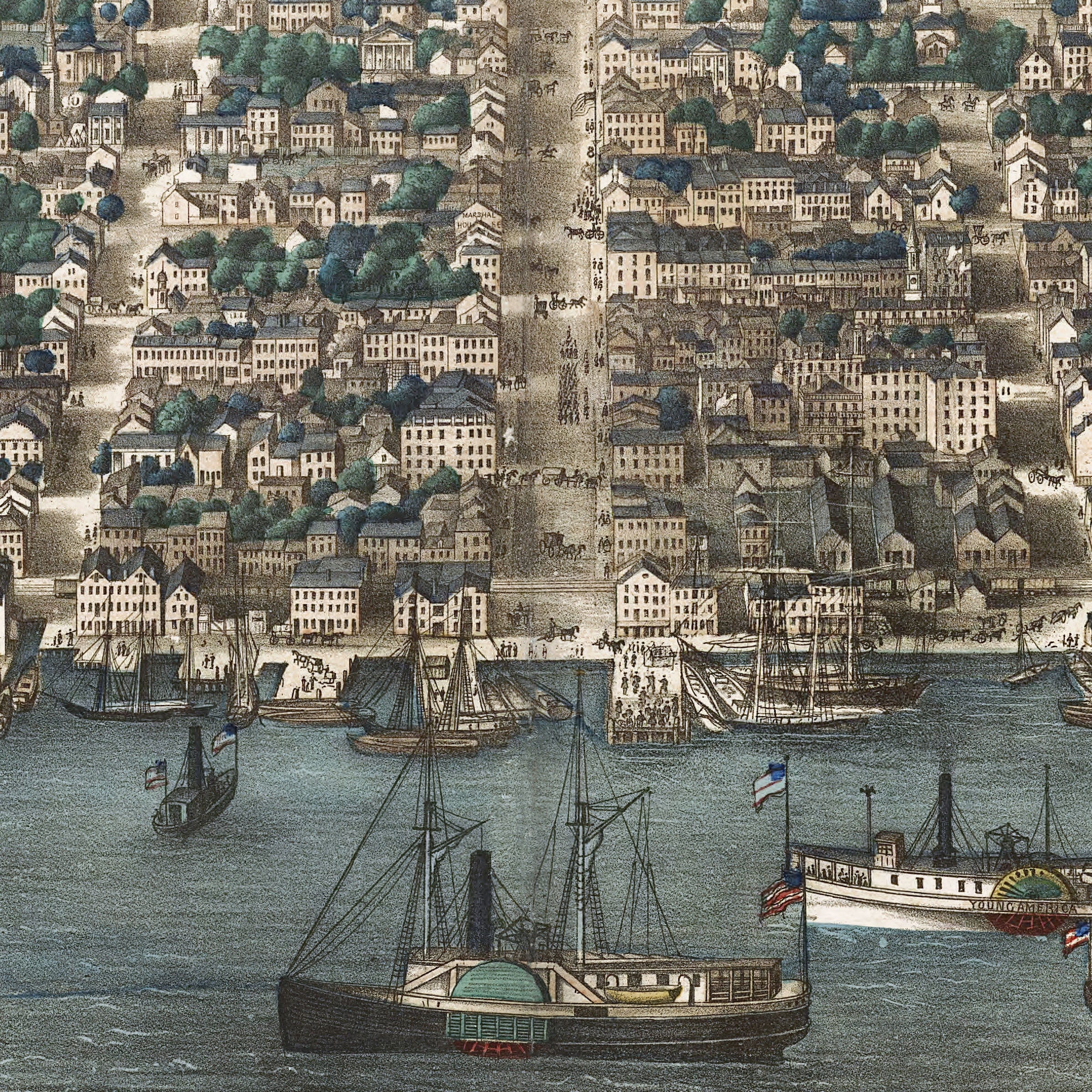
Step back to 1863 when this Alexandria, Virginia Map captured the northern Virginia city at a crossroads—an old port transformed overnight by the sweeping forces of the Civil War. This isn't just a bird's-eye lithograph—it's a portrait of extraordinary transition, when quiet antebellum rhythms had given way to the constant motion of a Union-occupied stronghold. Created by E. Sachse & Co., this sweeping view reveals Alexandria in a moment of dramatic change, reshaped by war yet still anchored in the landscape that defined it. The Alexandria, Virginia Map looks inland from above the busy waterfront, where steamboats, packet ships, and military transports crowd the wharves. Once a commercial harbor known for its flour mills and tobacco warehouses, Alexandria had become a vital logistical hub for the Union Army. The waterfront hums with the activity of war—troop carriers unloading regiments, hospital ships at anchor, and supply barges laden with food, munitions, and equipment. The Stars and Stripes snap from dozens of masts, signaling the federal presence that defined the city's wartime identity. Beyond the docks, a tightly knit grid of streets stretches toward the rolling Virginia countryside. Rows of brick townhouses, churches, and shops reflect Alexandria's roots as a prosperous colonial port, even as many of these buildings had been converted into barracks, offices, or hospitals. King Street, the city's historic commercial spine, cuts a straight line southward, flanked by markets, warehouses, and commandeered businesses that served both soldiers and civilians. Scattered across the rising hills, the defenses of Washington loom in the distance—fortifications built by Union engineers to guard the capital. Their presence underscores Alexandria's strategic importance, as does the visible network of roads and rail lines radiating outward. The Orange & Alexandria Railroad, a crucial artery for moving troops and supplies to the front, connects the city to the broader theater of war. Amid the bustle, hints of Alexandria's civilian life persist. Shaded residential districts, orchards, and open farmland remind the viewer that this was still a lived-in community, adapting to war while holding fast to its longstanding character. Churches with tall steeples rise above the rooftops, symbols of continuity in a time of upheaval. Each reproduction includes a custom historical letter detailing the story behind the map, making it perfect for Civil War historians, Virginia collectors, and American history enthusiasts. Printed on heavyweight archival paper or hand-stretched polycotton canvas, every building, ship, and street is restored in museum-grade clarity for generations of enjoyment. Paper prints ship rolled in heavy-duty tubes, while canvas editions arrive gallery-wrapped on solid pine stretcher bars with pre-installed hardware—ready to display the moment it arrives. Bring home a piece of Civil War history and celebrate the transformation of this historic Virginia port.
The Map Story
In 1863, Alexandria stood at a crossroads—an old port city transformed overnight by the sweeping forces of the Civil War. This bird’s-eye lithograph by E. Sachse & Co. captures the northern Virginia city in a moment of extraordinary transition, when its quiet antebellum rhythms had given way to the constant motion of a Union-occupied stronghold.
Set along the western shore of the Potomac River, the view looks inland from above the busy waterfront, where steamboats, packet ships, and military transports crowd the wharves. Once a commercial harbor known for its flour mills and tobacco warehouses, Alexandria had become a vital logistical hub for the Union Army. The waterfront hums with the activity of war—troop carriers unloading regiments, hospital ships at anchor, and supply barges laden with food, munitions, and equipment. The Stars and Stripes snap from dozens of masts, signaling the federal presence that defined the city’s wartime identity.
Beyond the docks, a tightly knit grid of streets stretches toward the rolling Virginia countryside. Rows of brick townhouses, churches, and shops reflect Alexandria’s roots as a prosperous colonial port, even as many of these buildings had been converted into barracks, offices, or hospitals. King Street, the city’s historic commercial spine, cuts a straight line southward, flanked by markets, warehouses, and commandeered businesses that served both soldiers and civilians.
Scattered across the rising hills, the defenses of Washington loom in the distance—fortifications built by Union engineers to guard the capital. Their presence underscores Alexandria’s strategic importance, as does the visible network of roads and rail lines radiating outward. The Orange & Alexandria Railroad, a crucial artery for moving troops and supplies to the front, connects the city to the broader theater of war.
Amid the bustle, hints of Alexandria’s civilian life persist. Shaded residential districts, orchards, and open farmland remind the viewer that this was still a lived-in community, adapting to war while holding fast to its longstanding character. Churches with tall steeples rise above the rooftops, symbols of continuity in a time of upheaval.
Sachse’s drawing preserves a city in the midst of dramatic change—its harbor thrumming with military purpose, its streets crowded with new demands, its skyline framed by the distant echoes of conflict. The map invites the viewer to witness Alexandria as it stood in 1863: a historic port reshaped by war yet still anchored in the landscape that defined it.
Materials
Choose options

Because every place has a story
Make History Personal
A vintage map is more than art.
It is a reminder of where life began.
Where memories were made.
Where hearts still live. Give the gift of place.
Beautifully preserved and made for the moments that matter.
Why Choose Us?
| Feature | Us | Competitor A | Competitor B |
|---|---|---|---|
| Hand Crafted | |||
| Museum Quality | |||
| 100 Year Guarantee | |||
| Restored by Hand | |||
| Certificate of Authenticity |

Art Prints
Archival quality colors. Best option if you'd like to frame it yourself

The Best Materials
We hand-stretched our canvas on solid American-grown pine stretcher bars. We use quality canvas and fade-resistant inks to create the lasting art. Canvases come with hardware already installed and ready to hang.
Need help?
Frequently Asked Questions
Order
All of our maps are meticulously restored reproductions of historic originals. Each piece is digitally repaired and color-corrected to bring out the finest details while preserving its authentic, vintage character.
Yes. All Archive Prints products are printed to order in the USA with archival materials.
We offer two premium formats:
- High-Quality Paper Posters – Printed on thick, archival-grade matte paper for rich, vibrant detail.
- Hand-Stretched Canvas Prints – Printed on premium polycotton canvas and mounted on 1.5" solid American pine stretcher bars for a gallery-quality finish.
We carefully digitally restore each map to enhance clarity and color while preserving its original look and historic charm. You’ll enjoy sharp details and a timeless vintage aesthetic that feels true to the original piece.
Yes, we do! We offer premium framing options to make your map ready to hang the moment it arrives. You can choose from Oak, Maple, Black, or Walnut frames directly on the product page. We also offer Stretched Canvas prints for a modern gallery look, as well as archival-quality Posters if you prefer to frame it yourself.
Yes! We offer free shipping on all products within the United States. Each map is carefully packaged to ensure it arrives in perfect condition.
If you’re not completely satisfied, you can return your order in new condition for a full refund. Return shipping costs are the responsibility of the customer.
Absolutely! Our maps make thoughtful, one-of-a-kind gifts for history lovers, map collectors, or anyone looking to add vintage character to their home or office. Choose between paper prints for framing or stretched canvas for a ready-to-hang presentation.
- Paper Posters → Shipped in durable, protective tubes to prevent creasing.
- Canvas Prints → Carefully wrapped, padded, and boxed to ensure safe delivery.
Our maps look stunning in a variety of settings, including:
- Living rooms and home offices
- Libraries and studies
- Corporate offices and conference rooms
- Restaurants, cafes, and boutique spaces