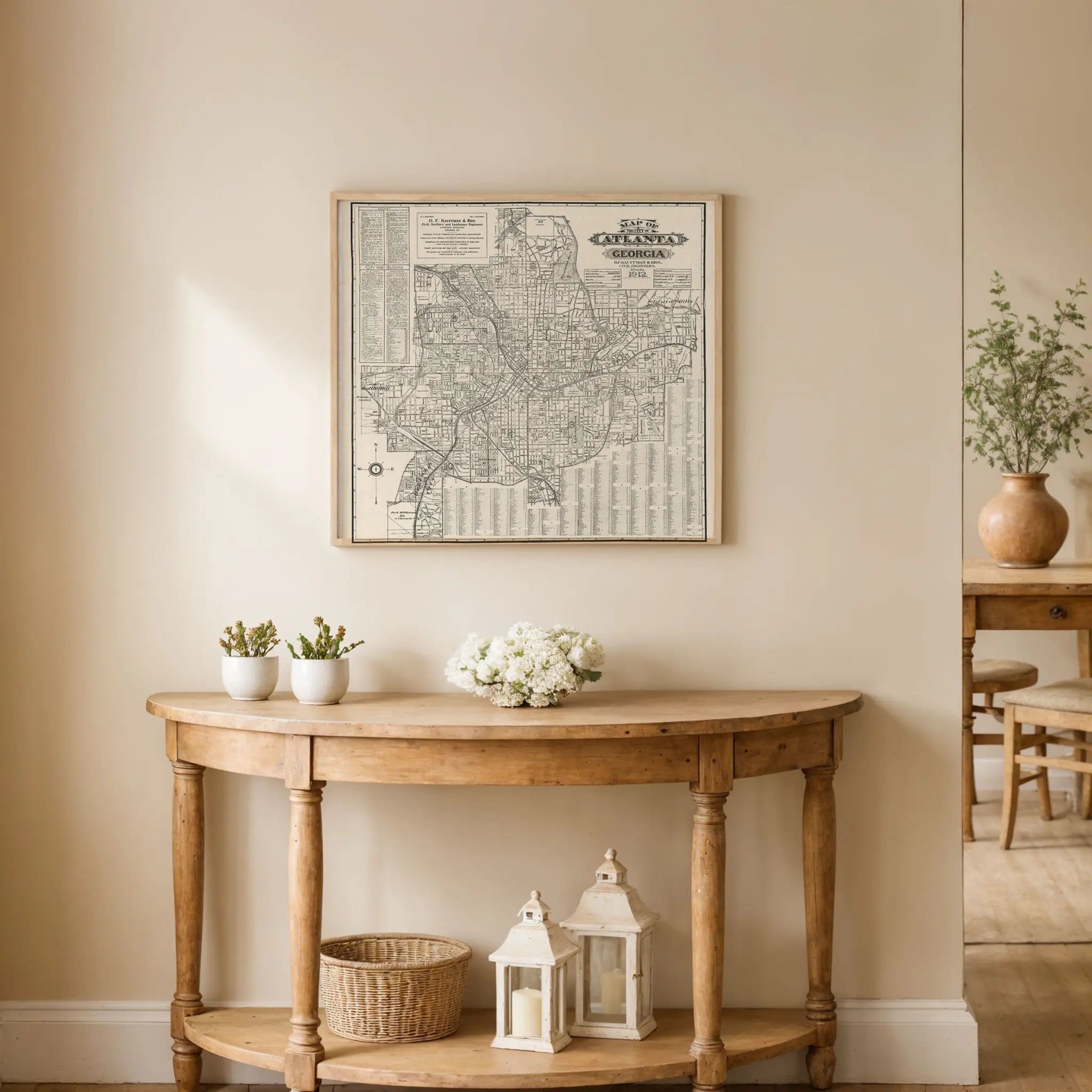


Atlanta Vintage Map 1912 - Historic Georgia City Map
Discover Atlanta's Progressive Era
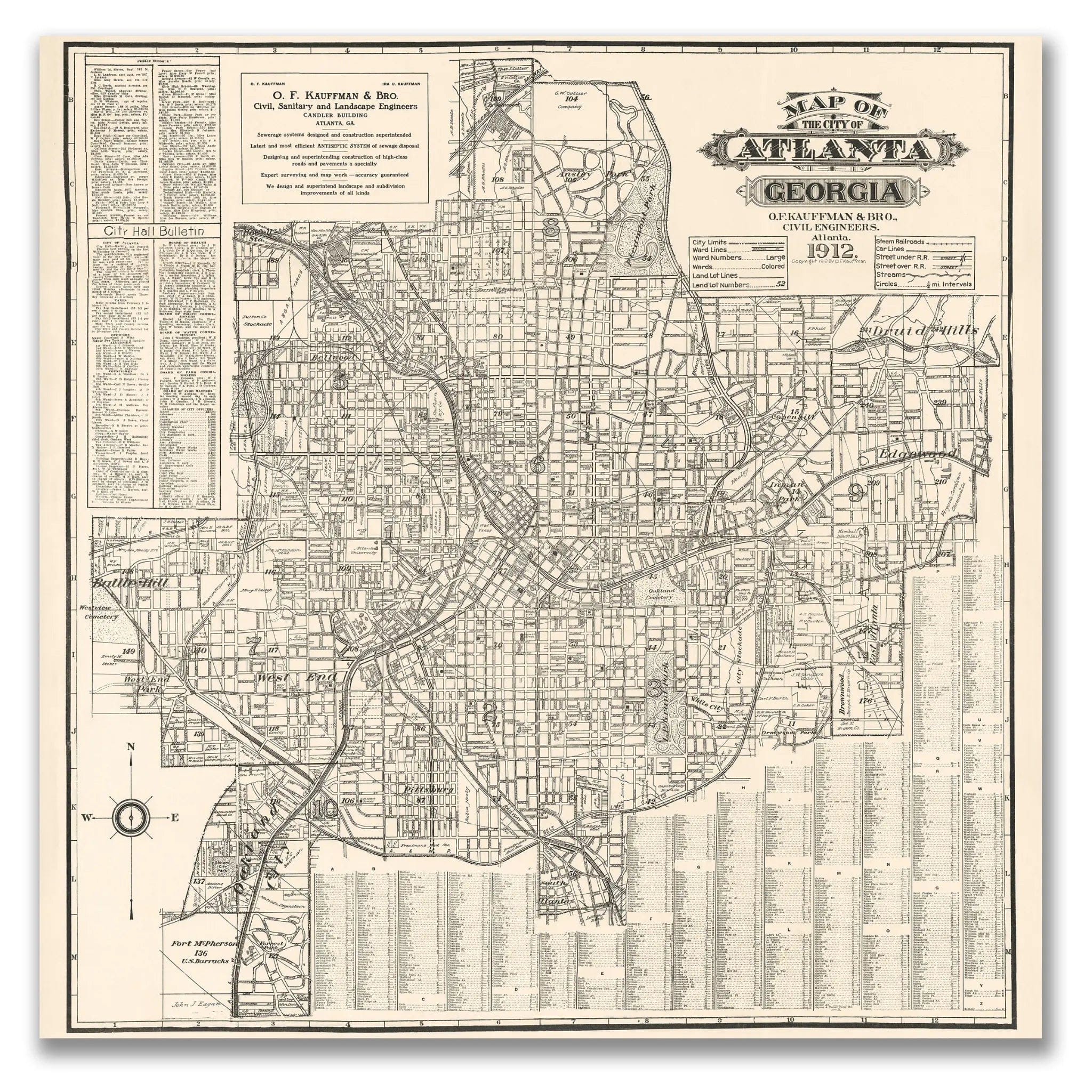
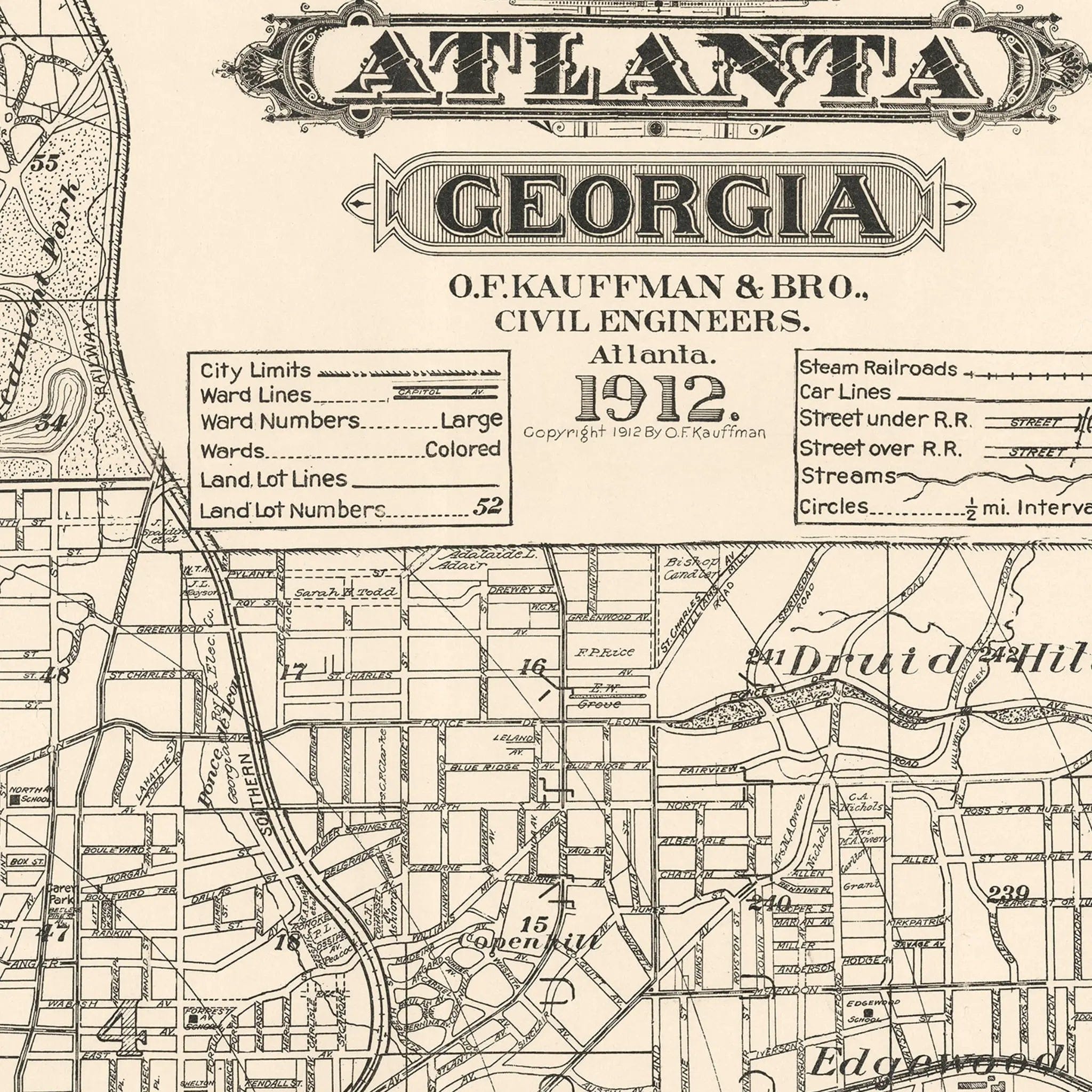
Step into the remarkable world of 1912 Atlanta with this extraordinary Map of the City of Atlanta, Georgia by O.F. Kauffman & Bro., Civil Engineers. This meticulously detailed city map captures Atlanta during its golden age of reconstruction and growth, when the city had risen from the ashes of the Civil War to become the undisputed commercial and transportation hub of the New South. Every street, railroad line, and neighborhood reflects a city that had transformed itself from wartime devastation into a symbol of Southern progress and prosperity.
Historical Significance
In 1912, Atlanta stood as the crown jewel of the New South, a city that had rebuilt itself with remarkable determination and vision. This comprehensive map documents Atlanta during a pivotal period when the city was experiencing unprecedented growth, driven by railroad connections that made it the transportation center of the Southeast. The detailed street grid, extensive railroad network, and substantial commercial districts shown in the map reflect a community that had embraced progress while honoring its heritage, creating a unique blend of Southern tradition and modern ambition.
Cartographic Excellence
Kauffman & Bro.'s masterful engineering survey showcases Atlanta with remarkable precision and attention to both urban development and infrastructure. The detailed rendering reveals the systematic planning that guided Atlanta's reconstruction, from the radiating street patterns that emanated from the railroad terminals to the carefully platted residential neighborhoods that housed the city's growing population. The map captures the essence of a modern Southern city, where electric streetcar lines connected thriving commercial districts with elegant residential areas.
Urban Development Story
The artistry of this map lies in its documentation of Atlanta's remarkable transformation from a railroad junction into the economic capital of the Southeast. The extensive railroad infrastructure, multiple streetcar lines, and substantial commercial buildings reflect the prosperity that came from Atlanta's strategic position as the gateway to the South. The careful attention to both established neighborhoods and new developments speaks to a community that was constantly growing and evolving, always looking toward the future while building on solid foundations.
A Vision of New South Progress
This map serves as a portrait of the New South ideal realized, capturing Atlanta when it had become the beating heart of Southern commerce and the symbol of regional renewal. The careful attention to both transportation infrastructure and civic institutions reflects a community that understood its role as the leader of Southern progress. The balance between commercial development and residential neighborhoods shows a city that prospered by embracing both economic opportunity and quality of life for its citizens.
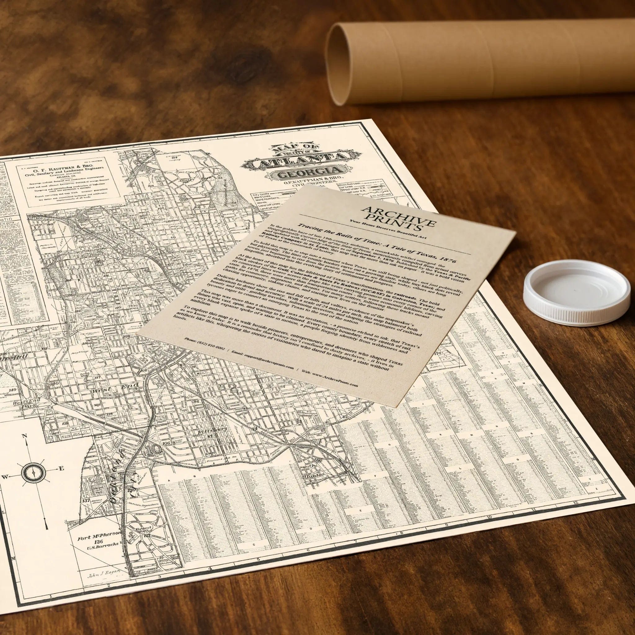
A Piece of Georgia History
Each restored reproduction of this 1912 map is printed with museum-quality precision on heavyweight archival paper or hand-stretched premium canvas to preserve every original detail. Your purchase includes two companion documents:
Certificate of Authenticity verifying its restoration and reproduction quality
Historical Story Page detailing the origins, craftsmanship, and cultural significance of Kauffman & Bro.'s iconic map
Paper prints arrive rolled in reinforced mailing tubes for protection. Canvas prints come gallery-wrapped on solid pine stretcher bars with pre-installed hardware, ready to display upon arrival.
Bring home a vivid piece of Georgia history—a timeless record of Atlanta's rise as the capital of the New South and the transportation hub that connected the region to the world.
The Map Story
Materials
Choose options

Because every place has a story
Make History Personal
A vintage map is more than art.
It is a reminder of where life began.
Where memories were made.
Where hearts still live. Give the gift of place.
Beautifully preserved and made for the moments that matter.
Why Choose Us?
| Feature | Us | Competitor A | Competitor B |
|---|---|---|---|
| Hand Crafted | |||
| Museum Quality | |||
| 100 Year Guarantee | |||
| Restored by Hand | |||
| Certificate of Authenticity |

Art Prints
Archival quality colors. Best option if you'd like to frame it yourself

The Best Materials
We hand-stretched our canvas on solid American-grown pine stretcher bars. We use quality canvas and fade-resistant inks to create the lasting art. Canvases come with hardware already installed and ready to hang.
Need help?
Frequently Asked Questions
Order
All of our maps are meticulously restored reproductions of historic originals. Each piece is digitally repaired and color-corrected to bring out the finest details while preserving its authentic, vintage character.
Yes. All Archive Prints products are printed to order in the USA with archival materials.
We offer two premium formats:
- High-Quality Paper Posters – Printed on thick, archival-grade matte paper for rich, vibrant detail.
- Hand-Stretched Canvas Prints – Printed on premium polycotton canvas and mounted on 1.5" solid American pine stretcher bars for a gallery-quality finish.
We carefully digitally restore each map to enhance clarity and color while preserving its original look and historic charm. You’ll enjoy sharp details and a timeless vintage aesthetic that feels true to the original piece.
Yes, we do! We offer premium framing options to make your map ready to hang the moment it arrives. You can choose from Oak, Maple, Black, or Walnut frames directly on the product page. We also offer Stretched Canvas prints for a modern gallery look, as well as archival-quality Posters if you prefer to frame it yourself.
Yes! We offer free shipping on all products within the United States. Each map is carefully packaged to ensure it arrives in perfect condition.
If you’re not completely satisfied, you can return your order in new condition for a full refund. Return shipping costs are the responsibility of the customer.
Absolutely! Our maps make thoughtful, one-of-a-kind gifts for history lovers, map collectors, or anyone looking to add vintage character to their home or office. Choose between paper prints for framing or stretched canvas for a ready-to-hang presentation.
- Paper Posters → Shipped in durable, protective tubes to prevent creasing.
- Canvas Prints → Carefully wrapped, padded, and boxed to ensure safe delivery.
Our maps look stunning in a variety of settings, including:
- Living rooms and home offices
- Libraries and studies
- Corporate offices and conference rooms
- Restaurants, cafes, and boutique spaces