
Austin Bird's-Eye Map - Vintage 1887 Texas State Capital Historical Map for Collectors
Step Back to 1887 Austin: Where the Colorado River Meets Central Texas Heritage
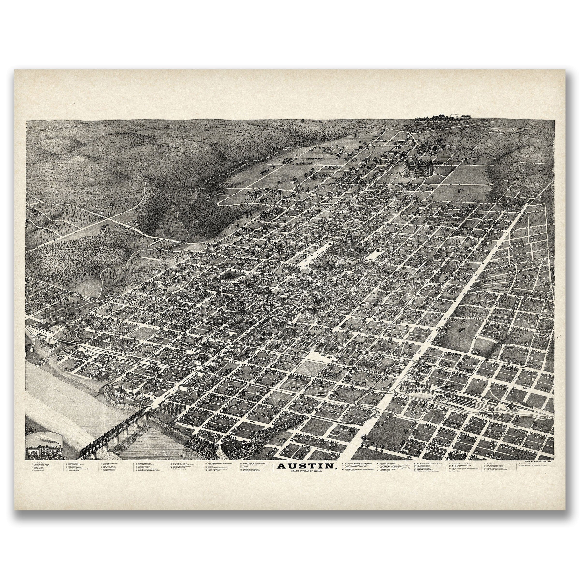
This remarkable bird's-eye view captures Austin, Texas in 1887, when the town stood as a vital crossroads along the Colorado River in the heart of Central Texas. Published by the renowned cartographer Augustus Koch, this map presents Austin during its golden age as a thriving river town, complete with detailed illustrations of individual buildings, tree-lined streets, and the bustling activity of a community at the center of regional commerce and culture.
Historical Significance
In 1887, Austin was experiencing a period of remarkable growth and prosperity. As one of the oldest settlements in Texas, founded in 1832, the town had evolved from a frontier outpost into a sophisticated community that served as the county seat and a crucial stop along major transportation routes. The Colorado River provided both transportation and power for local mills, while the surrounding pine forests supported a thriving lumber industry that shipped timber throughout Texas and beyond.
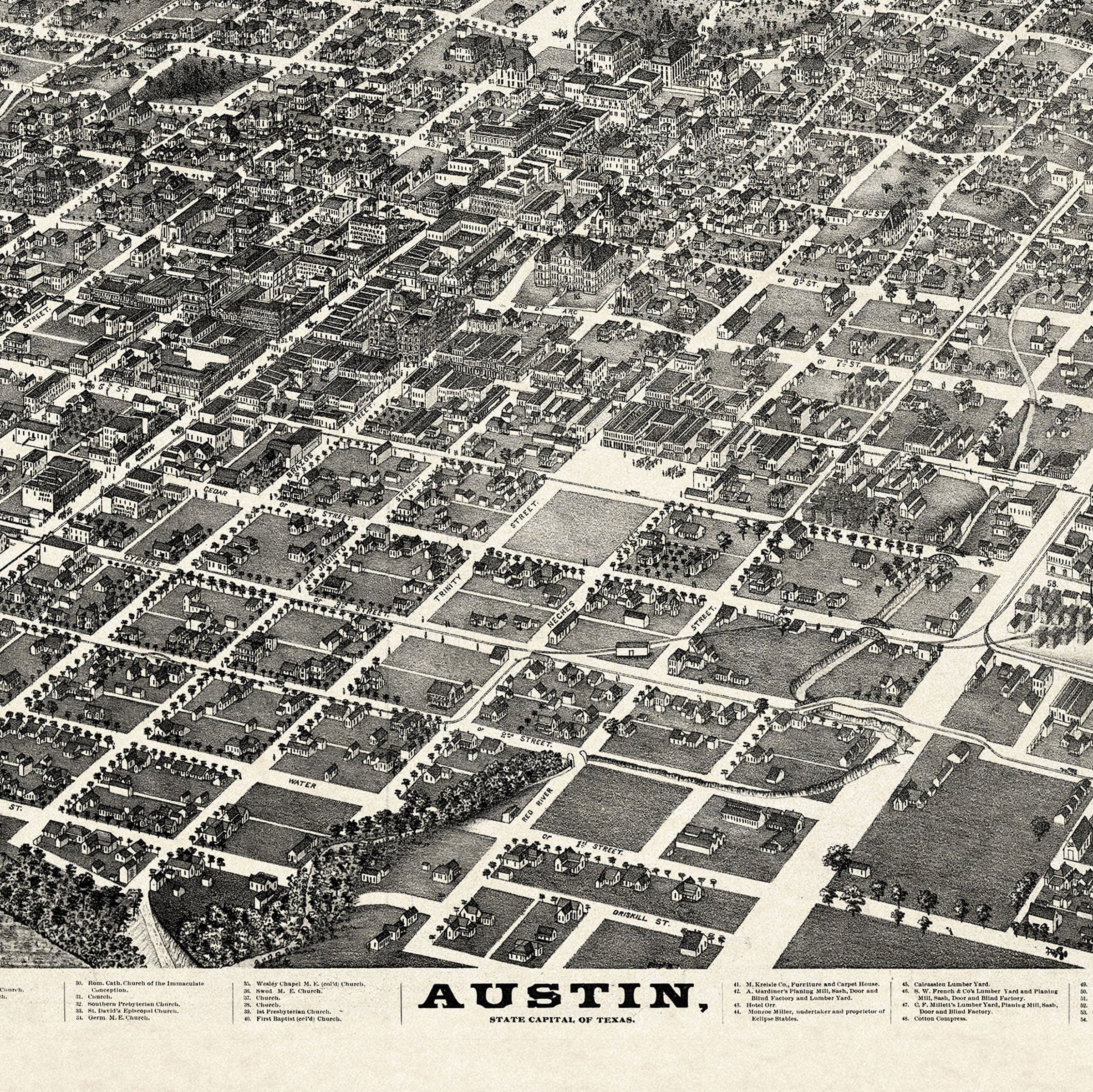
This bird's-eye view captures Austin at a pivotal moment when the town was balancing its frontier heritage with modern aspirations. The detailed street grid shows Water Street running parallel to the Colorado River, while Pecan, Sterling, Chestnut, and Jefferson Streets create the orderly pattern of a well-planned community. Each building is rendered with careful attention to architectural detail, from the prominent courthouse and churches to the commercial establishments and family homes that defined the town's character.
Cartographic Excellence
Augustus Koch was renowned for his ability to combine artistic vision with cartographic precision, and this Austin map exemplifies his mastery of the bird's-eye view format. The perspective allows viewers to appreciate both the town's relationship to the natural landscape and the intricate details of daily life. Koch's technique captures the rolling hills of Central Texas, the meandering path of the Colorado River, and the careful placement of buildings that reflects the community's thoughtful development.
The map serves as both a historical document and a work of art, preserving the visual memory of a Texas town during a crucial period of growth and transformation. Every structure, from the grandest public buildings to the most modest residences, is depicted with the kind of detail that allows modern viewers to imagine the daily rhythms of life in 1887 Austin.
The Spirit of Progress
What makes this map particularly compelling is how it captures the optimism and forward momentum of a community confident in its future. The orderly streets, substantial buildings, and thriving commercial district all speak to a town that had successfully navigated the challenges of frontier life and was positioning itself for continued growth. The presence of churches, schools, and civic buildings demonstrates the community's commitment to education, faith, and good governance.
The map also reflects the unique cultural blend that characterized Central Texas in this era. Austin's population included Anglo settlers, Mexican families who had lived in the region for generations, and European immigrants drawn by opportunities in lumber, agriculture, and commerce. This diversity is subtly reflected in the architectural styles and community layout that Koch so carefully documented.
A Legacy Preserved
Today, this 1887 bird's-eye view serves as an invaluable window into Austin's past, allowing us to see the town as it appeared to residents and visitors more than a century ago. The map has been carefully digitally restored to preserve every detail while enhancing clarity and color. Each print is produced on archival-quality materials designed to last for generations, ensuring that this remarkable piece of Texas history can be enjoyed by future generations.
Whether displayed in a home, office, or public space, this map connects viewers to the rich heritage of Central Texas and the enduring spirit of communities that grew and thrived along the banks of the Colorado River. It stands as a testament to the vision and determination of the people who built Austin into the charming and historic town it remains today.
The Map Story
This panoramic bird’s-eye view of Austin, published in 1887, offers a striking portrait of the Texas capital in the late nineteenth century. Drawn with meticulous detail, the map captures the city as it spread outward from the banks of the Colorado River, set against the backdrop of rolling hills and open countryside. At this time, Austin was transitioning from a frontier capital into a growing urban center, defined by its government institutions, rail connections, and cultural ambitions.
The most prominent feature on the map is the Texas State Capitol, completed just a year later in 1888. Here, the building’s location is shown dominating the central grid of streets, a symbol of Austin’s political importance. The city’s neatly ordered blocks radiate from Congress Avenue, the grand boulevard that linked the Capitol to the Colorado River and remains Austin’s central artery today.
The Colorado River itself anchors the bottom of the map. A bridge spans its waters, tying the north and south banks together and foreshadowing the importance of river crossings for the city’s growth. Ferry landings, mills, and warehouses along the river reveal how this natural resource powered both commerce and daily life. The surrounding hills, dotted with trees and paths, frame the settlement in a dramatic landscape that emphasized Austin’s identity as both a civic center and a place of natural beauty.
Transportation and progress are recurring themes. The map depicts rail lines entering the city, part of the network that tied Austin to Houston, San Antonio, and the wider nation. Streetcars, still drawn by mule power in the 1880s, ran along the main thoroughfares, connecting neighborhoods and encouraging suburban development. These innovations reflected Austin’s aspirations to join the ranks of modern American cities while still retaining the intimacy of a small community.
Landmarks such as churches, schools, and businesses are carefully labeled, preserving a snapshot of civic life. Institutions like the University of Texas, founded in 1883, are also visible, signaling the city’s emerging role as a center for education and culture. Residential areas stretch outward in a checkerboard of lots, some already filled with homes and others awaiting future growth.
Materials
Choose options

Because every place has a story
Make History Personal
A vintage map is more than art.
It is a reminder of where life began.
Where memories were made.
Where hearts still live. Give the gift of place.
Beautifully preserved and made for the moments that matter.
Why Choose Us?
| Feature | Us | Competitor A | Competitor B |
|---|---|---|---|
| Hand Crafted | |||
| Museum Quality | |||
| 100 Year Guarantee | |||
| Restored by Hand | |||
| Certificate of Authenticity |

Art Prints
Archival quality colors. Best option if you'd like to frame it yourself

The Best Materials
We hand-stretched our canvas on solid American-grown pine stretcher bars. We use quality canvas and fade-resistant inks to create the lasting art. Canvases come with hardware already installed and ready to hang.
Need help?
Frequently Asked Questions
Order
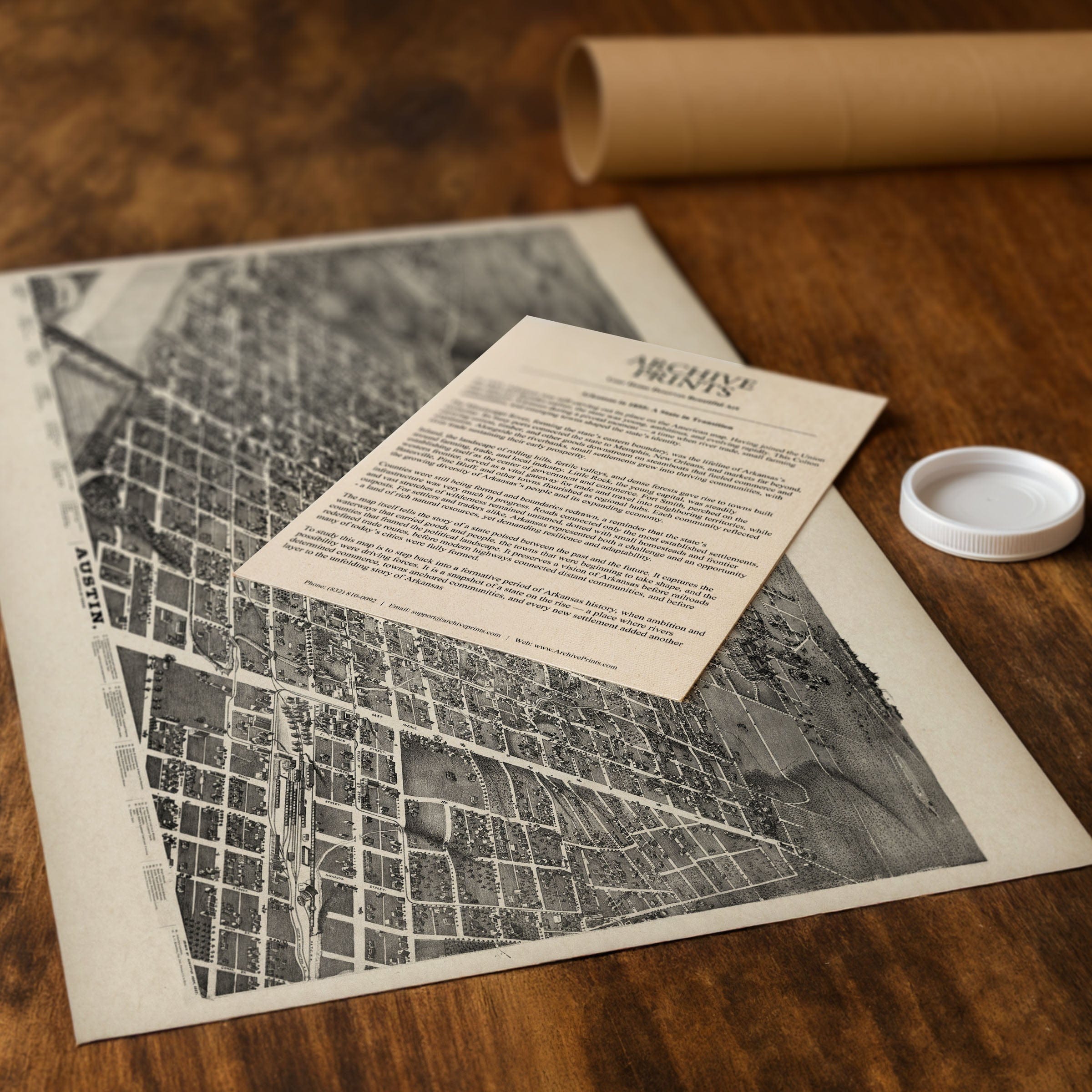
All of our maps are meticulously restored reproductions of historic originals. Each piece is digitally repaired and color-corrected to bring out the finest details while preserving its authentic, vintage character.
Yes. All Archive Prints products are printed to order in the USA with archival materials.
We offer two premium formats:
- High-Quality Paper Posters – Printed on thick, archival-grade matte paper for rich, vibrant detail.
- Hand-Stretched Canvas Prints – Printed on premium polycotton canvas and mounted on 1.5" solid American pine stretcher bars for a gallery-quality finish.
We carefully digitally restore each map to enhance clarity and color while preserving its original look and historic charm. You’ll enjoy sharp details and a timeless vintage aesthetic that feels true to the original piece.
Yes, we do! We offer premium framing options to make your map ready to hang the moment it arrives. You can choose from Oak, Maple, Black, or Walnut frames directly on the product page. We also offer Stretched Canvas prints for a modern gallery look, as well as archival-quality Posters if you prefer to frame it yourself.
Yes! We offer free shipping on all products within the United States. Each map is carefully packaged to ensure it arrives in perfect condition.
If you’re not completely satisfied, you can return your order in new condition for a full refund. Return shipping costs are the responsibility of the customer.
Absolutely! Our maps make thoughtful, one-of-a-kind gifts for history lovers, map collectors, or anyone looking to add vintage character to their home or office. Choose between paper prints for framing or stretched canvas for a ready-to-hang presentation.
- Paper Posters → Shipped in durable, protective tubes to prevent creasing.
- Canvas Prints → Carefully wrapped, padded, and boxed to ensure safe delivery.
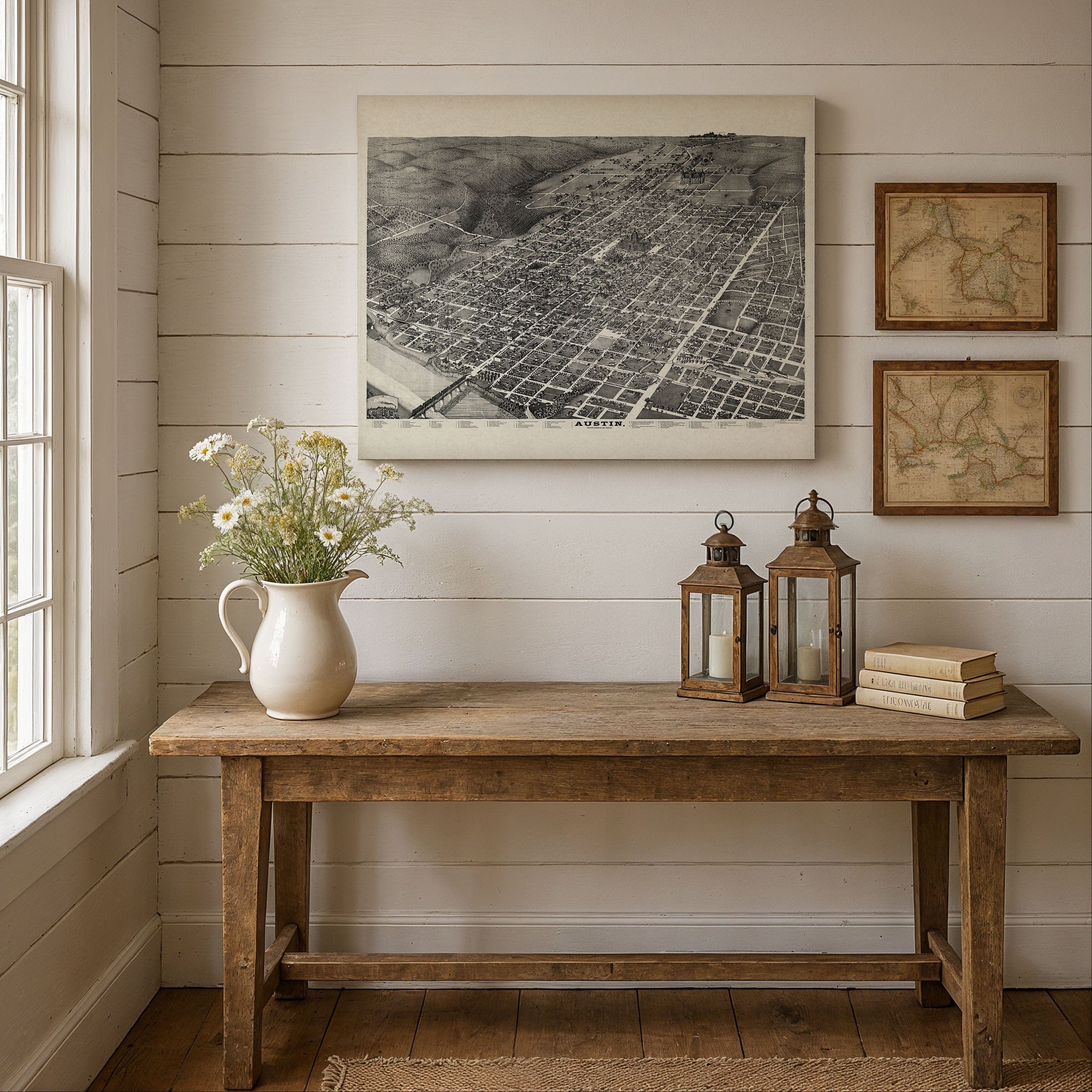
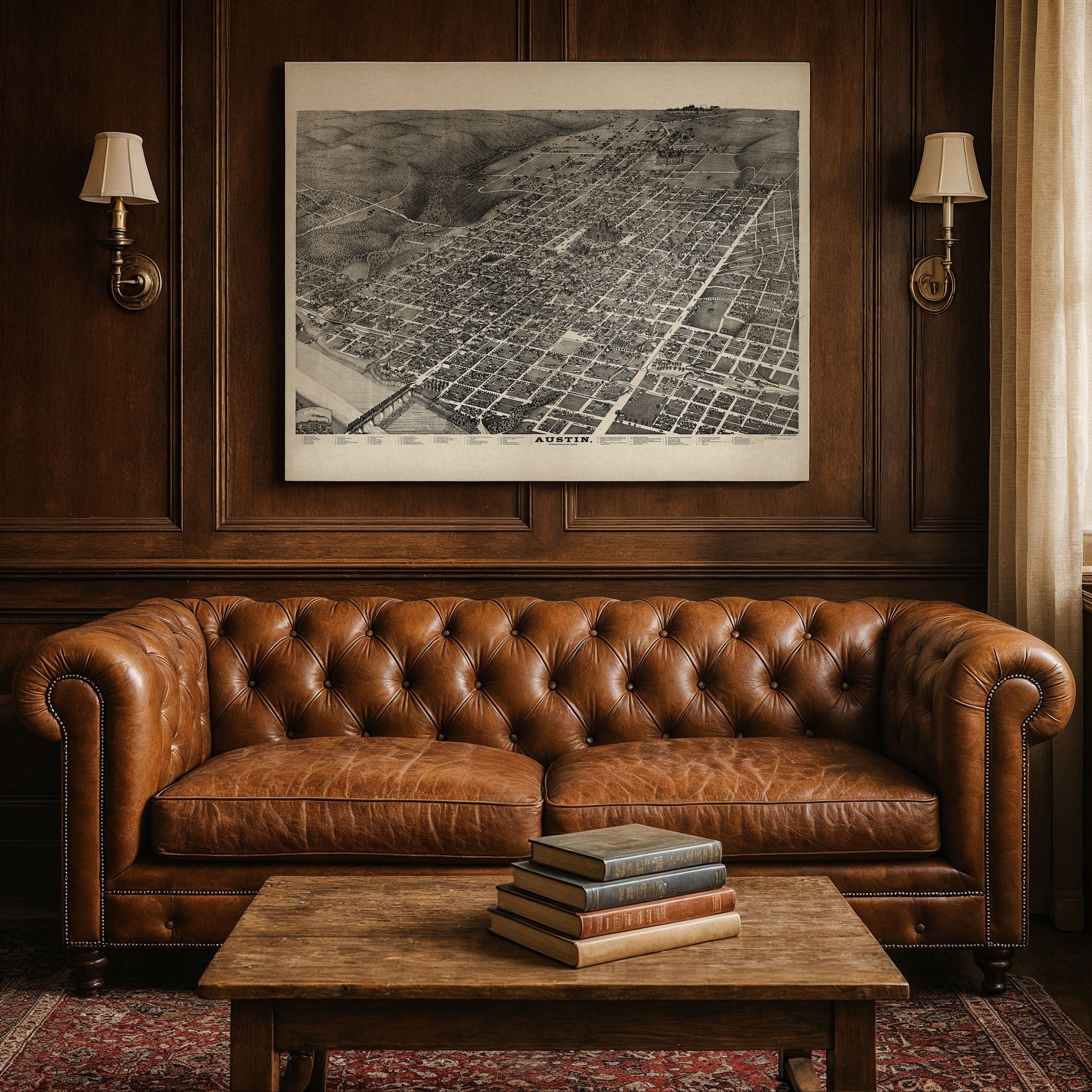
Our maps look stunning in a variety of settings, including:
- Living rooms and home offices
- Libraries and studies
- Corporate offices and conference rooms
- Restaurants, cafes, and boutique spaces