California Gold & Quicksilver District Map 1848
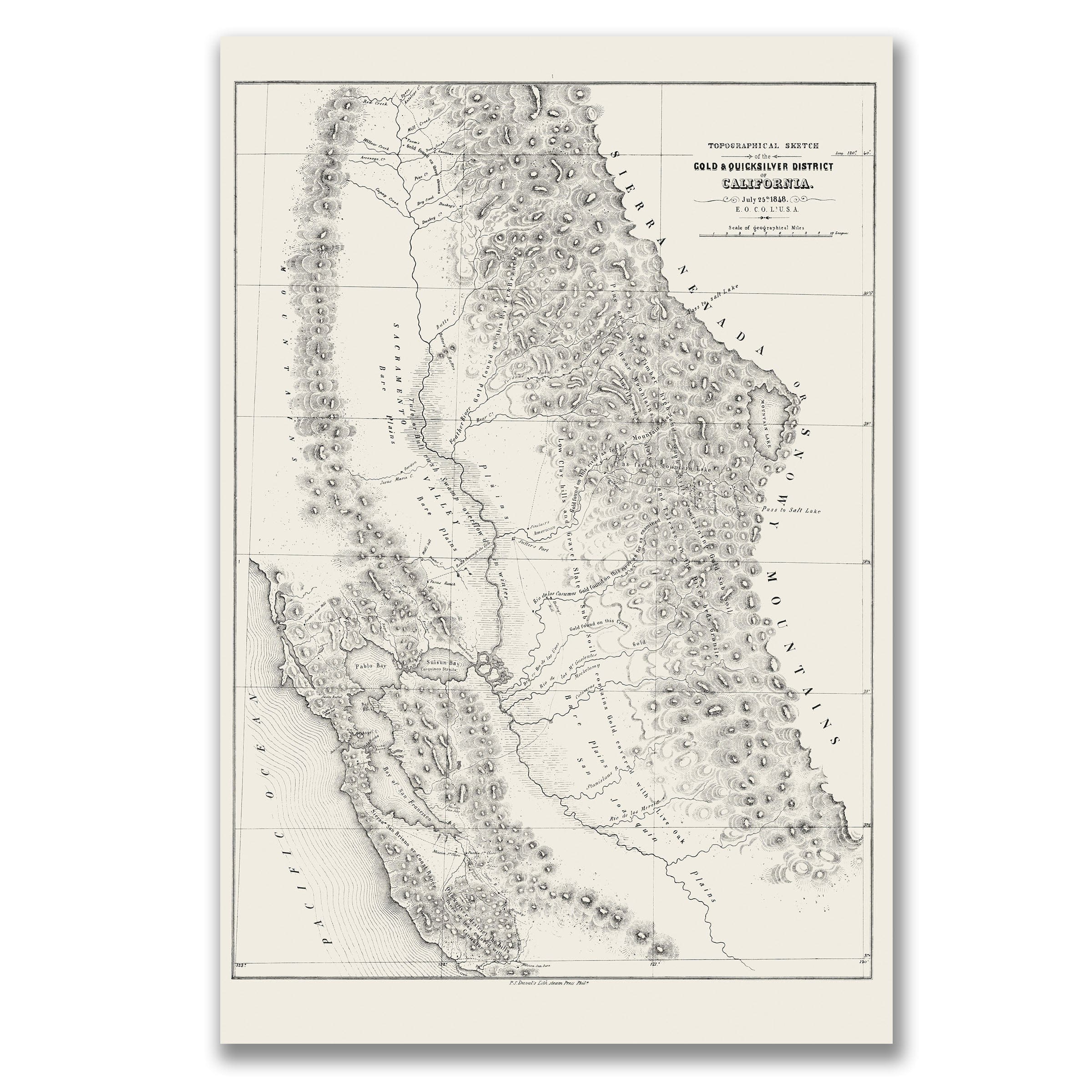
Discover the historic California Gold & Quicksilver District Map from 1848 that captures California on the brink of a transformation that would reverberate across the nation. This vintage map style topographical sketch by Lieutenant E. O. C. Ord showcases the region at the precise moment when the discovery of gold along the American River was beginning to ignite the greatest migration in American history, drawn just months after James Marshall found the first flakes at Coloma. The California Gold & Quicksilver District Map reveals a landscape not yet overwhelmed by miners, but already pulsing with possibility during the earliest days of the California Gold Rush. Rendered with military precision, this old map aesthetic sketch stretches from the Pacific coast through the rugged spine of the Sierra Nevada, tracing the river valleys, mountain passes, and mineral-rich foothills that would soon draw tens of thousands westward in search of fortune. In an era before railroads or organized routes, Ord's vintage map depiction served as both guide and promise—highlighting the very terrain where gold lay scattered in riverbeds and quartz veins throughout the goldfields of Northern California. The Sacramento Valley appears as a broad, fertile plain, its waterways marked carefully, for the rivers were the lifelines by which prospectors traveled inland from the bays of San Francisco and San Pablo during the early Gold Rush period. Eastward, the topography grows increasingly dramatic in this old map, with the Sierra Nevada rising in dense clusters of peaks, ridges, and ravines—each rendered with tight stippling that conveys both danger and opportunity for gold seekers. Labels such as "Gold Region," "Quicksilver Mine," and "Pass to Salt Lake" point to a region whose future industries were only beginning to be imagined, revealing early trails threading into the mountains as faint indicators of the routes that would soon become wagon roads for thousands of hopeful fortune seekers. Though simple at first glance, this vintage map captures a turning point when California was not yet a U.S. state but a distant, lightly settled frontier whose future suddenly seemed boundless after the discovery of gold at Sutter's Mill. Ord's sketch, prepared for military and governmental use, functioned as one of the earliest geographic summaries of the goldfields—offering a rare glimpse into the landscape before the boomtowns, before the claims, and before the frenzy that would reshape the American West. In this moment—before the Gold Rush became a national obsession—this old map preserves California on the edge of seismic change, with E. O. C. Ord's work standing as both record and witness, inviting the viewer to see the land as it was when gold remained largely hidden, awaiting the rush that would define an era. Each reproduction includes a custom historical letter detailing the story behind the map, making it perfect for California collectors, Gold Rush enthusiasts, and American West historians. Printed on heavyweight archival paper or hand-stretched polycotton canvas, every mountain peak, river valley, and mining district detail is rendered in museum-grade clarity for generations of enjoyment. Paper prints ship rolled in heavy-duty tubes, while canvas editions arrive gallery-wrapped on solid pine stretcher bars with pre-installed hardware—ready to display the moment it arrives. Bring home the spirit of 1848 California and celebrate the moment when gold was discovered and the American West was forever changed.
The Map Story
Materials
Choose options

Because every place has a story
Make History Personal
A vintage map is more than art.
It is a reminder of where life began.
Where memories were made.
Where hearts still live. Give the gift of place.
Beautifully preserved and made for the moments that matter.
Why Choose Us?
| Feature | Us | Competitor A | Competitor B |
|---|---|---|---|
| Hand Crafted | |||
| Museum Quality | |||
| 100 Year Guarantee | |||
| Restored by Hand | |||
| Certificate of Authenticity |

Art Prints
Archival quality colors. Best option if you'd like to frame it yourself

The Best Materials
We hand-stretched our canvas on solid American-grown pine stretcher bars. We use quality canvas and fade-resistant inks to create the lasting art. Canvases come with hardware already installed and ready to hang.
Need help?
Frequently Asked Questions
Order
All of our maps are meticulously restored reproductions of historic originals. Each piece is digitally repaired and color-corrected to bring out the finest details while preserving its authentic, vintage character.
Yes. All Archive Prints products are printed to order in the USA with archival materials.
We offer two premium formats:
- High-Quality Paper Posters – Printed on thick, archival-grade matte paper for rich, vibrant detail.
- Hand-Stretched Canvas Prints – Printed on premium polycotton canvas and mounted on 1.5" solid American pine stretcher bars for a gallery-quality finish.
We carefully digitally restore each map to enhance clarity and color while preserving its original look and historic charm. You’ll enjoy sharp details and a timeless vintage aesthetic that feels true to the original piece.
Yes, we do! We offer premium framing options to make your map ready to hang the moment it arrives. You can choose from Oak, Maple, Black, or Walnut frames directly on the product page. We also offer Stretched Canvas prints for a modern gallery look, as well as archival-quality Posters if you prefer to frame it yourself.
Yes! We offer free shipping on all products within the United States. Each map is carefully packaged to ensure it arrives in perfect condition.
If you’re not completely satisfied, you can return your order in new condition for a full refund. Return shipping costs are the responsibility of the customer.
Absolutely! Our maps make thoughtful, one-of-a-kind gifts for history lovers, map collectors, or anyone looking to add vintage character to their home or office. Choose between paper prints for framing or stretched canvas for a ready-to-hang presentation.
- Paper Posters → Shipped in durable, protective tubes to prevent creasing.
- Canvas Prints → Carefully wrapped, padded, and boxed to ensure safe delivery.
Our maps look stunning in a variety of settings, including:
- Living rooms and home offices
- Libraries and studies
- Corporate offices and conference rooms
- Restaurants, cafes, and boutique spaces