California Map 1885
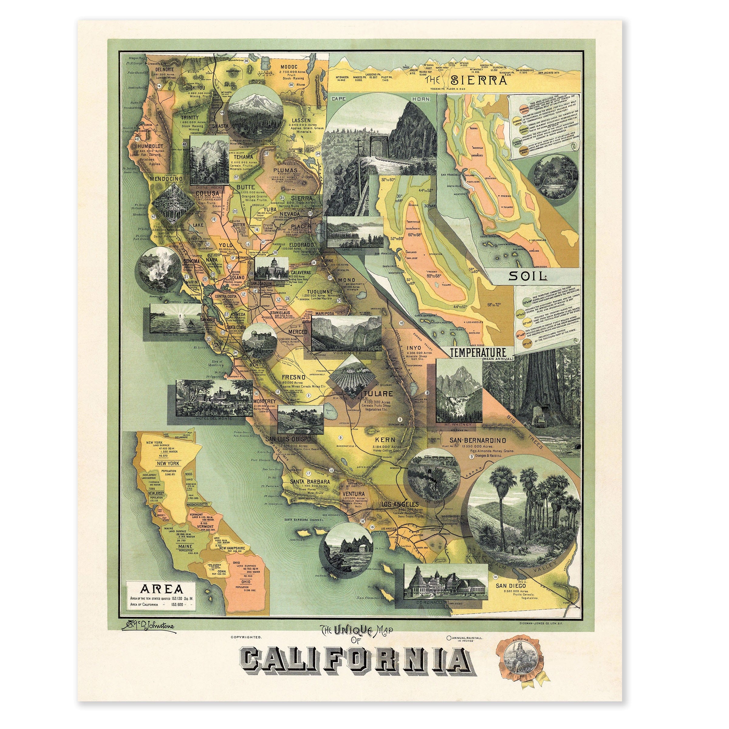
Discover the historic California Map from 1885 that captures the Golden State as a land of astonishing contrasts—an emerging Pacific empire whose identity was still being shaped by its landscapes, climates, and boundless natural resources. This vintage map style richly illustrated "Unique Map of California" by L. J. Schramm was created during a period of rapid settlement and industrial expansion, showcasing California at a moment when railroads, agriculture, mining, and tourism were transforming it into one of the most dynamic regions of the nation. The California Map serves as a visual tapestry, weaving together counties, climate zones, soil types, and geological features into a single sweeping portrait that reflects the state's extraordinary diversity during the height of westward expansion. In the center, county boundaries reflect the patchwork nature of settlement, while engravings of waterfalls, forests, mountains, and coastal scenes frame the state's remarkable geography in this old map aesthetic. From the redwood groves of Humboldt and Mendocino to the citrus orchards emerging in Los Angeles and San Bernardino, California appears as a place where multiple worlds coexist in this vintage map representation. To the east, an inset of the Sierra Nevada reveals the massive mountain spine that defined the state's geography and weather, with detailed diagrams of temperature ranges and soil classifications that underscore California's growing agricultural reputation during the 1880s. High valleys suitable for wheat and livestock give way to warmer interior plains where fruit, vegetables, and grapes flourish, as the state was already marketing itself as an agricultural paradise—fertile, varied, and unconstrained by the seasons that shaped life in the East. This old map features railroad lines stretching across the counties as symbols of California's new connectivity, with the transcontinental railroad completed only 16 years earlier and its branches now reaching deep into farming districts, mining towns, and coastal ports. These iron routes brought settlers, capital, and national attention, fueling population growth and turning cities like San Francisco, Sacramento, and Los Angeles into regional power centers during the Gilded Age. Tourism, too, was beginning to flourish in this vintage map era, as travelers ventured to places like Yosemite, the giant sequoias, and the southern coast in search of scenery and sunshine that would define California's appeal. The images surrounding this old map celebrate the state's magnitude: snow-covered peaks, fertile valleys, mighty rivers, and coastal harbors that linked California to the Pacific world and international trade. This vintage map immortalizes California at a moment of bold imagination—when every mountain, orchard, and shoreline seemed to promise opportunity, inviting the viewer to see the Golden State through 19th-century eyes: vast, varied, and brimming with possibility, poised to become a symbol of American ambition and natural wonder. Each reproduction includes a custom historical letter detailing the story behind the map, making it perfect for California collectors, history enthusiasts, and lovers of American West heritage. Printed on heavyweight archival paper or hand-stretched polycotton canvas, every county, mountain range, and agricultural detail is rendered in museum-grade clarity for generations of enjoyment. Paper prints ship rolled in heavy-duty tubes, while canvas editions arrive gallery-wrapped on solid pine stretcher bars with pre-installed hardware—ready to display the moment it arrives. Bring home the spirit of 1885 California and celebrate the Golden State's transformation into America's Pacific empire.
The Map Story
Materials
Choose options

Because every place has a story
Make History Personal
A vintage map is more than art.
It is a reminder of where life began.
Where memories were made.
Where hearts still live. Give the gift of place.
Beautifully preserved and made for the moments that matter.
Why Choose Us?
| Feature | Us | Competitor A | Competitor B |
|---|---|---|---|
| Hand Crafted | |||
| Museum Quality | |||
| 100 Year Guarantee | |||
| Restored by Hand | |||
| Certificate of Authenticity |

Art Prints
Archival quality colors. Best option if you'd like to frame it yourself

The Best Materials
We hand-stretched our canvas on solid American-grown pine stretcher bars. We use quality canvas and fade-resistant inks to create the lasting art. Canvases come with hardware already installed and ready to hang.
Need help?
Frequently Asked Questions
Order
All of our maps are meticulously restored reproductions of historic originals. Each piece is digitally repaired and color-corrected to bring out the finest details while preserving its authentic, vintage character.
Yes. All Archive Prints products are printed to order in the USA with archival materials.
We offer two premium formats:
- High-Quality Paper Posters – Printed on thick, archival-grade matte paper for rich, vibrant detail.
- Hand-Stretched Canvas Prints – Printed on premium polycotton canvas and mounted on 1.5" solid American pine stretcher bars for a gallery-quality finish.
We carefully digitally restore each map to enhance clarity and color while preserving its original look and historic charm. You’ll enjoy sharp details and a timeless vintage aesthetic that feels true to the original piece.
Yes, we do! We offer premium framing options to make your map ready to hang the moment it arrives. You can choose from Oak, Maple, Black, or Walnut frames directly on the product page. We also offer Stretched Canvas prints for a modern gallery look, as well as archival-quality Posters if you prefer to frame it yourself.
Yes! We offer free shipping on all products within the United States. Each map is carefully packaged to ensure it arrives in perfect condition.
If you’re not completely satisfied, you can return your order in new condition for a full refund. Return shipping costs are the responsibility of the customer.
Absolutely! Our maps make thoughtful, one-of-a-kind gifts for history lovers, map collectors, or anyone looking to add vintage character to their home or office. Choose between paper prints for framing or stretched canvas for a ready-to-hang presentation.
- Paper Posters → Shipped in durable, protective tubes to prevent creasing.
- Canvas Prints → Carefully wrapped, padded, and boxed to ensure safe delivery.
Our maps look stunning in a variety of settings, including:
- Living rooms and home offices
- Libraries and studies
- Corporate offices and conference rooms
- Restaurants, cafes, and boutique spaces