

Tampa Vintage Map - 1913 Lithograph of City of Tampa, West Tampa, and Surrounding Areas
Discover the Rise of Florida’s Gulf Coast Gateway
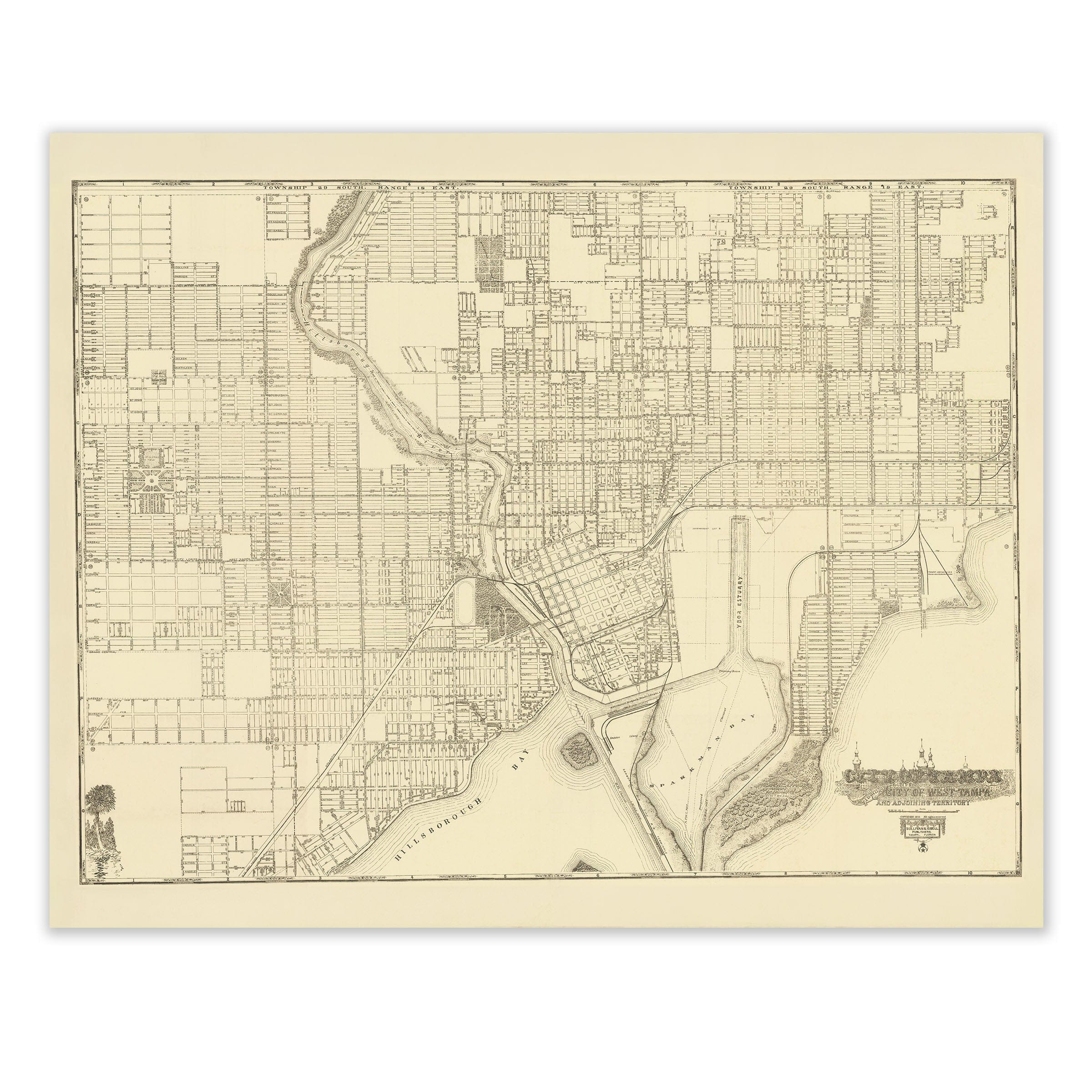
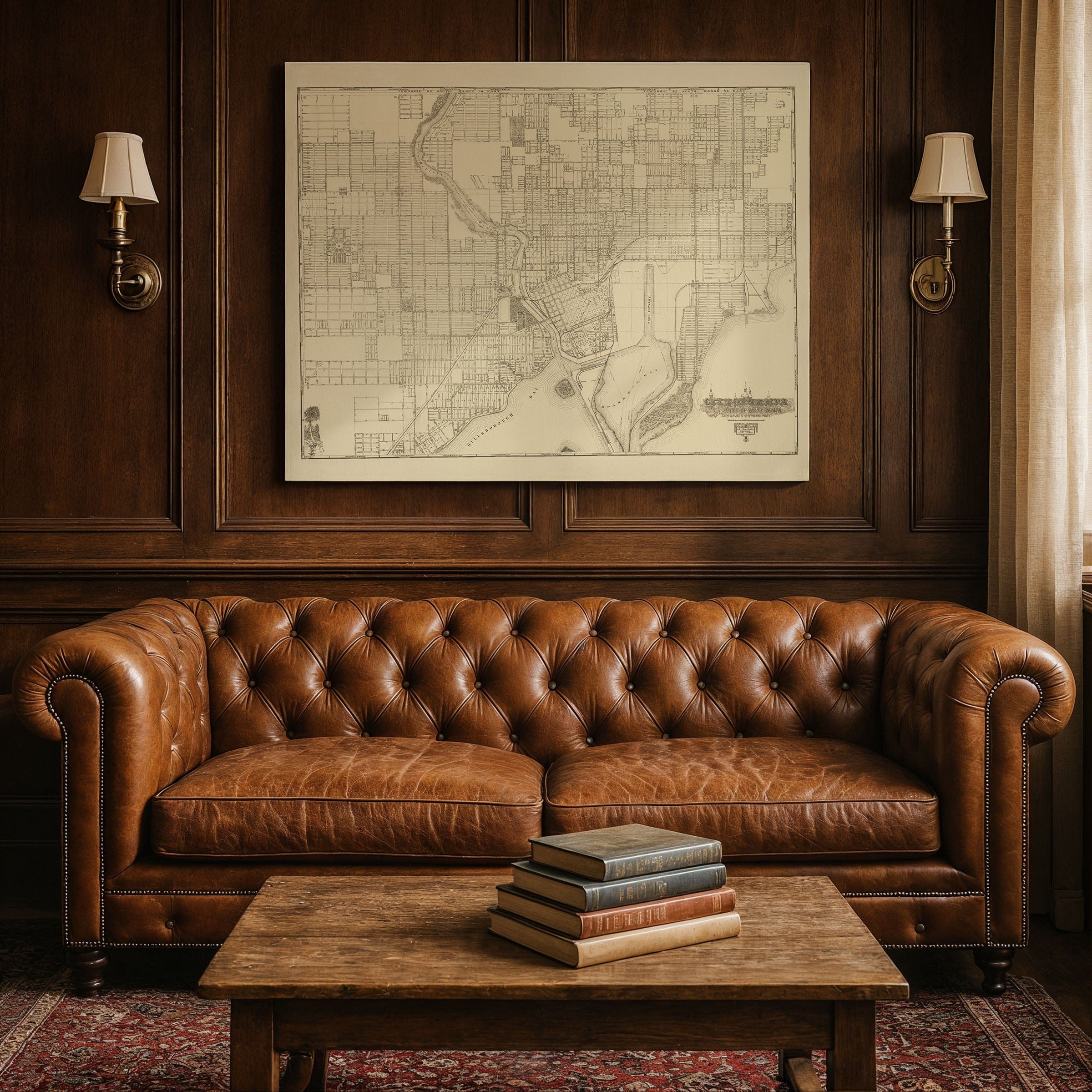
Step back to 1913 and witness Tampa at the height of its early transformation with this beautifully restored City of Tampa Including City of West Tampa and Adjoining Territory map, originally published by Sullivan & Isbell. This remarkable lithograph captures the city as it stood on the brink of modern growth—where railroads, shipping, and the booming cigar industry converged to make Tampa one of Florida’s most dynamic coastal cities.
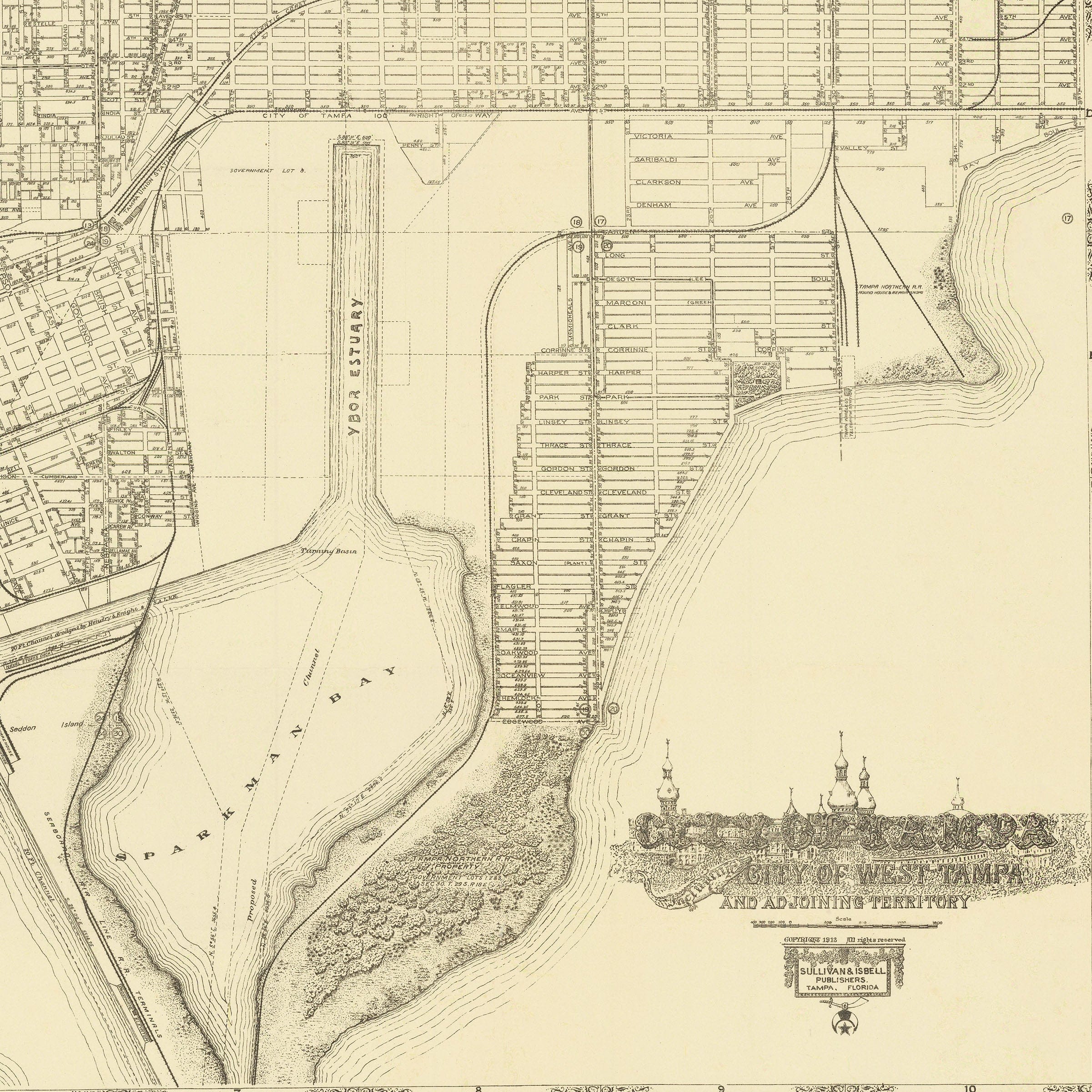
Drawn with striking precision, the map reveals Tampa’s expanding grid, its bridges crossing the Hillsborough River, and the growing connection between Tampa and the once-separate city of West Tampa. Every street, parcel, and railway spur is clearly labeled, showing a city alive with ambition. The bustling waterfront, lined with docks and shipping piers, speaks to Tampa’s central role in Gulf trade, while the intricate web of railroad lines underscores its importance as a transportation hub linking Florida’s agricultural and industrial heartlands.
Equally captivating is the detailed depiction of West Tampa, a thriving district defined by its cigar factories, worker neighborhoods, and immigrant communities. The map’s careful rendering of these industrial zones reveals the partnership between culture and commerce that gave Tampa its unique identity. Together, Tampa and West Tampa form a portrait of progress—bridging history, geography, and opportunity.
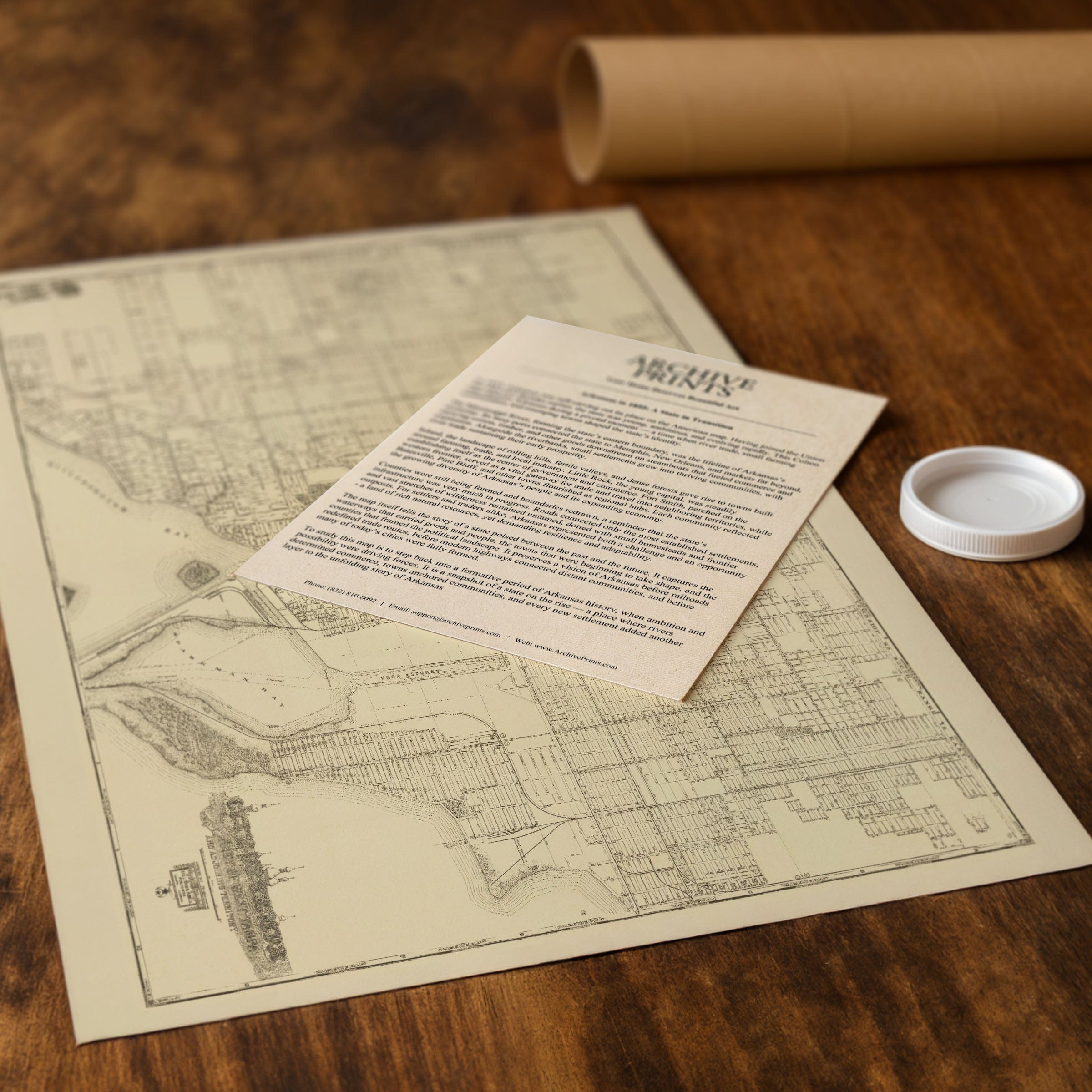
Each reproduction includes a custom historical letter that explores the story behind the map, making it an exceptional centerpiece for collectors, historians, and Florida enthusiasts. Printed with archival precision on heavyweight matte paper or hand-stretched polycotton canvas, every line, block, and landmark is restored in ultra-high definition to preserve the artistry of the original lithograph.
Paper prints are rolled in sturdy mailing tubes for protection, while canvas editions arrive gallery-wrapped on solid pine stretcher bars with pre-installed hardware, ready to hang right out of the box.
Bring home a piece of Tampa’s early 20th-century history—a testament to the spirit of growth, innovation, and coastal enterprise that shaped the city we know today.
The Map Story
In 1913, Tampa was emerging as a vibrant port city and melting pot. This detailed lithograph, City of Tampa Including City of West Tampa and Adjoining Territory, published by Sullivan & Isbell, protrays a city in transition, where rail, shipping, industry, and migration collide in bold lines and fine print.
From above the waterfront, the map lays out Tampa’s street grid, railroad lines, and parcels with precision. The Hillsborough River slices the city, creating separation yet connection between Tampa proper and West Tampa. Bridges and ferries appear as lifelines, framing the movement of people, goods, and ideas.
West Tampa is drawn in with equal weight—not as an afterthought but as a partner in growth. Once a distinct city, West Tampa was rapidly integrating into Tampa’s commercial orbit, especially through the cigar industry. The map captures this synergy: factories, rail spurs, and worker housing cluster tight, suggesting dense economic life behind the façades.
Every street is named, every parcel is dimensioned. Parks, churches, major buildings, and railroad yards receive careful illustration. The waterfront shows docks, piers, and shipping channels—evidence that Tampa’s life depended heavily on maritime commerce as much as rail. The railroad lines draw routes inland, linking Tampa to the citrus groves, phosphate mines, and citrus processing towns across Florida.
It’s also a map of invitation and persuasion. The artists designed it for both residents and investors. By showing vacant lots, undeveloped parcels, and suburban expansion, the map whispers promise: there is still room to grow. The clarity of titles, street labels, and infrastructure pitches confidence.
Seen now, the 1913 map offers a window into Tampa’s early 20th-century ambition. It shows a city with one foot in its frontier past and the other stepping boldly toward modernization. The river, rail, industry, and neighborhoods all move together. And West Tampa, once a separate city, becomes essential to the vision of Tampa’s future.
Materials
Choose options

Because every place has a story
Make History Personal
A vintage map is more than art.
It is a reminder of where life began.
Where memories were made.
Where hearts still live. Give the gift of place.
Beautifully preserved and made for the moments that matter.
Why Choose Us?
| Feature | Us | Competitor A | Competitor B |
|---|---|---|---|
| Hand Crafted | |||
| Museum Quality | |||
| 100 Year Guarantee | |||
| Restored by Hand | |||
| Certificate of Authenticity |

Art Prints
Archival quality colors. Best option if you'd like to frame it yourself

The Best Materials
We hand-stretched our canvas on solid American-grown pine stretcher bars. We use quality canvas and fade-resistant inks to create the lasting art. Canvases come with hardware already installed and ready to hang.
Need help?
Frequently Asked Questions
Order
All of our maps are meticulously restored reproductions of historic originals. Each piece is digitally repaired and color-corrected to bring out the finest details while preserving its authentic, vintage character.
Yes. All Archive Prints products are printed to order in the USA with archival materials.
We offer two premium formats:
- High-Quality Paper Posters – Printed on thick, archival-grade matte paper for rich, vibrant detail.
- Hand-Stretched Canvas Prints – Printed on premium polycotton canvas and mounted on 1.5" solid American pine stretcher bars for a gallery-quality finish.
We carefully digitally restore each map to enhance clarity and color while preserving its original look and historic charm. You’ll enjoy sharp details and a timeless vintage aesthetic that feels true to the original piece.
Yes, we do! We offer premium framing options to make your map ready to hang the moment it arrives. You can choose from Oak, Maple, Black, or Walnut frames directly on the product page. We also offer Stretched Canvas prints for a modern gallery look, as well as archival-quality Posters if you prefer to frame it yourself.
Yes! We offer free shipping on all products within the United States. Each map is carefully packaged to ensure it arrives in perfect condition.
If you’re not completely satisfied, you can return your order in new condition for a full refund. Return shipping costs are the responsibility of the customer.
Absolutely! Our maps make thoughtful, one-of-a-kind gifts for history lovers, map collectors, or anyone looking to add vintage character to their home or office. Choose between paper prints for framing or stretched canvas for a ready-to-hang presentation.
- Paper Posters → Shipped in durable, protective tubes to prevent creasing.
- Canvas Prints → Carefully wrapped, padded, and boxed to ensure safe delivery.
Our maps look stunning in a variety of settings, including:
- Living rooms and home offices
- Libraries and studies
- Corporate offices and conference rooms
- Restaurants, cafes, and boutique spaces