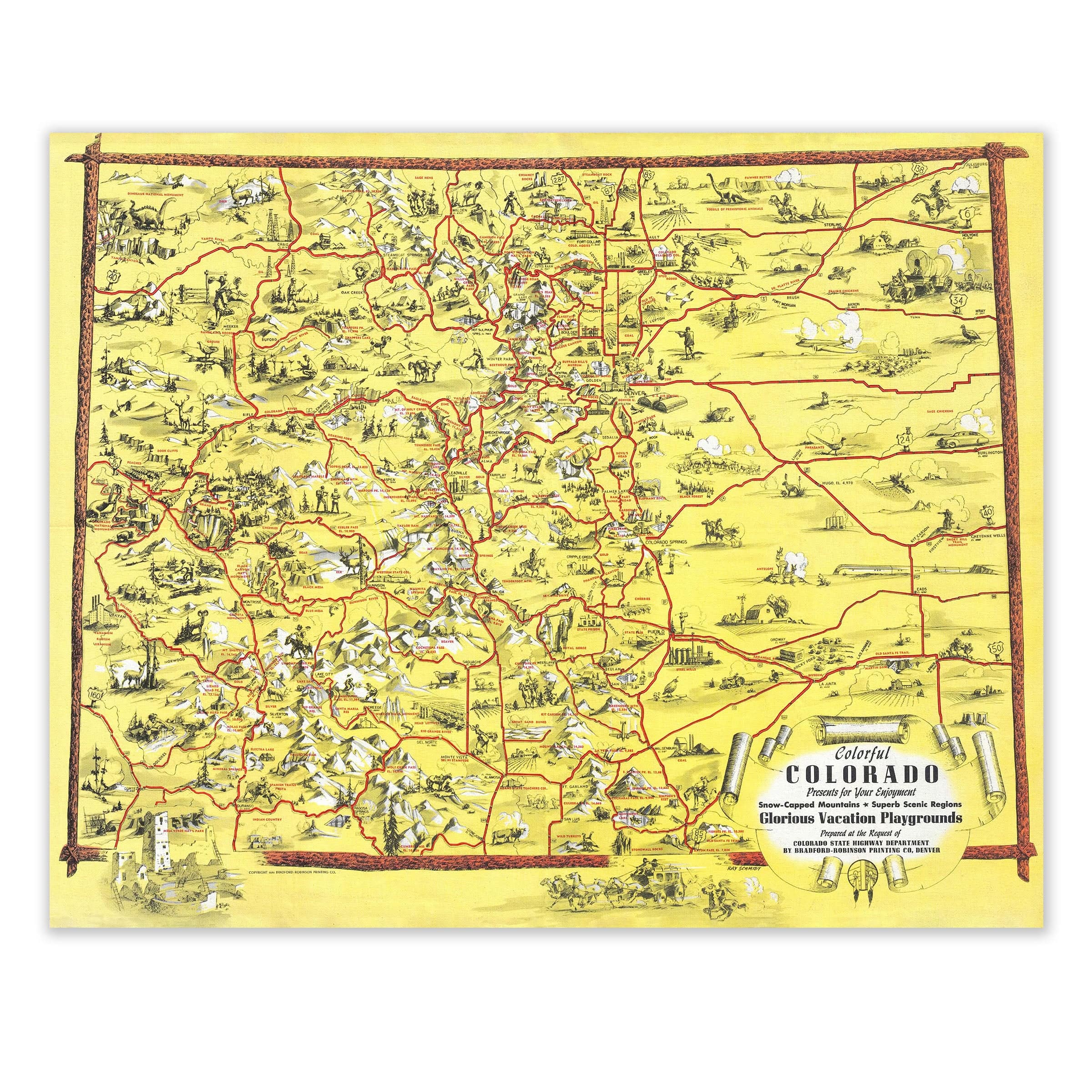

Colorful Colorado 1940 Vintage Pictorial Map Lithograph
Discover Colorado’s Wild Heart in Full Color
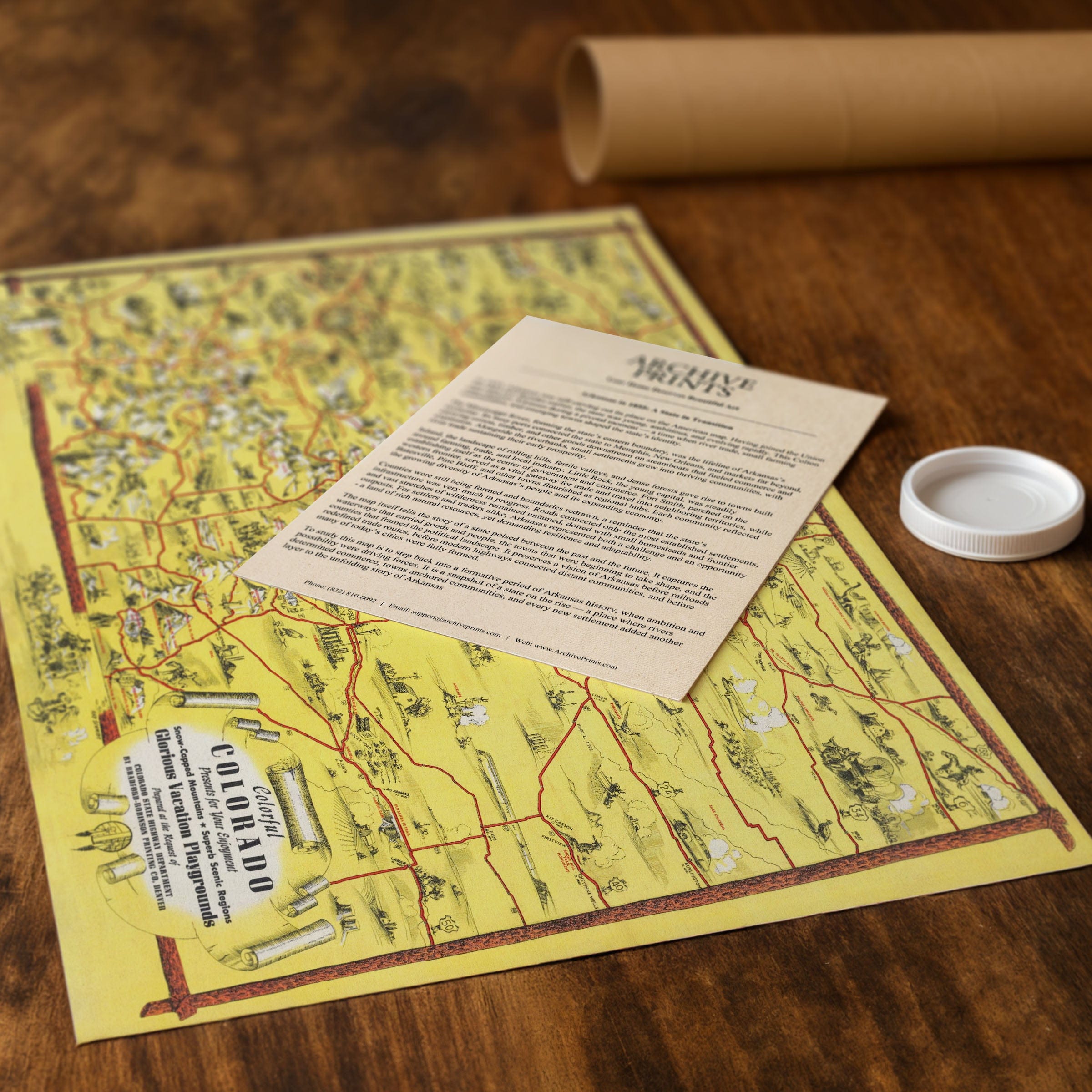
Explore the sweeping terrain and rich heritage of the Centennial State with this meticulously restored “Colorful Colorado” map—originally published in 1940 by Rand-McNally. This standout lithograph captures Colorado at a pivotal point: where rugged mountains, growing cities, and the promise of recreation converged into one remarkable panorama. Created just as Colorado’s identity began shifting from mining outposts to outdoor playground, the map presents a landscape alive with contrast and opportunity. From Denver’s grid to the high Rockies, every peak, river valley, and winding highway is rendered in vibrant detail. Cast your eye across the page and you’ll see how settlement followed the rails, how tourism edged into wilderness, and how modern life began to unfold in even the remotest corners. The map functions as more than geography—it narrates a story of transformation. Elk and bighorn sheep graze Alpine meadows; skiers traverse snowy slopes; motorcars and buses chart access to valleys once reachable only by mule. It is a visual testament to the state’s reinvention: wilderness tamed not by industry alone, but by leisure, travel, and the appreciation of nature’s grandeur. Each reproduction includes a custom historical letter detailing the map’s significance, making it an ideal addition for collectors, historians, and anyone drawn to the lure of the mountains. Printed with precision on heavyweight archival paper or hand-stretched premium canvas, every contour, highway line, and highlighted landmark is brought to life with museum-grade clarity through expert digital restoration. Paper prints arrive rolled in sturdy mailing tubes, while canvas prints come gallery-wrapped on solid pine stretcher bars with pre-installed hardware—ready to display the moment they arrive. Bring home a piece of Colorado’s scenic legacy and celebrate a state defined by peaks and plains, ambition and escape.
The Map Story
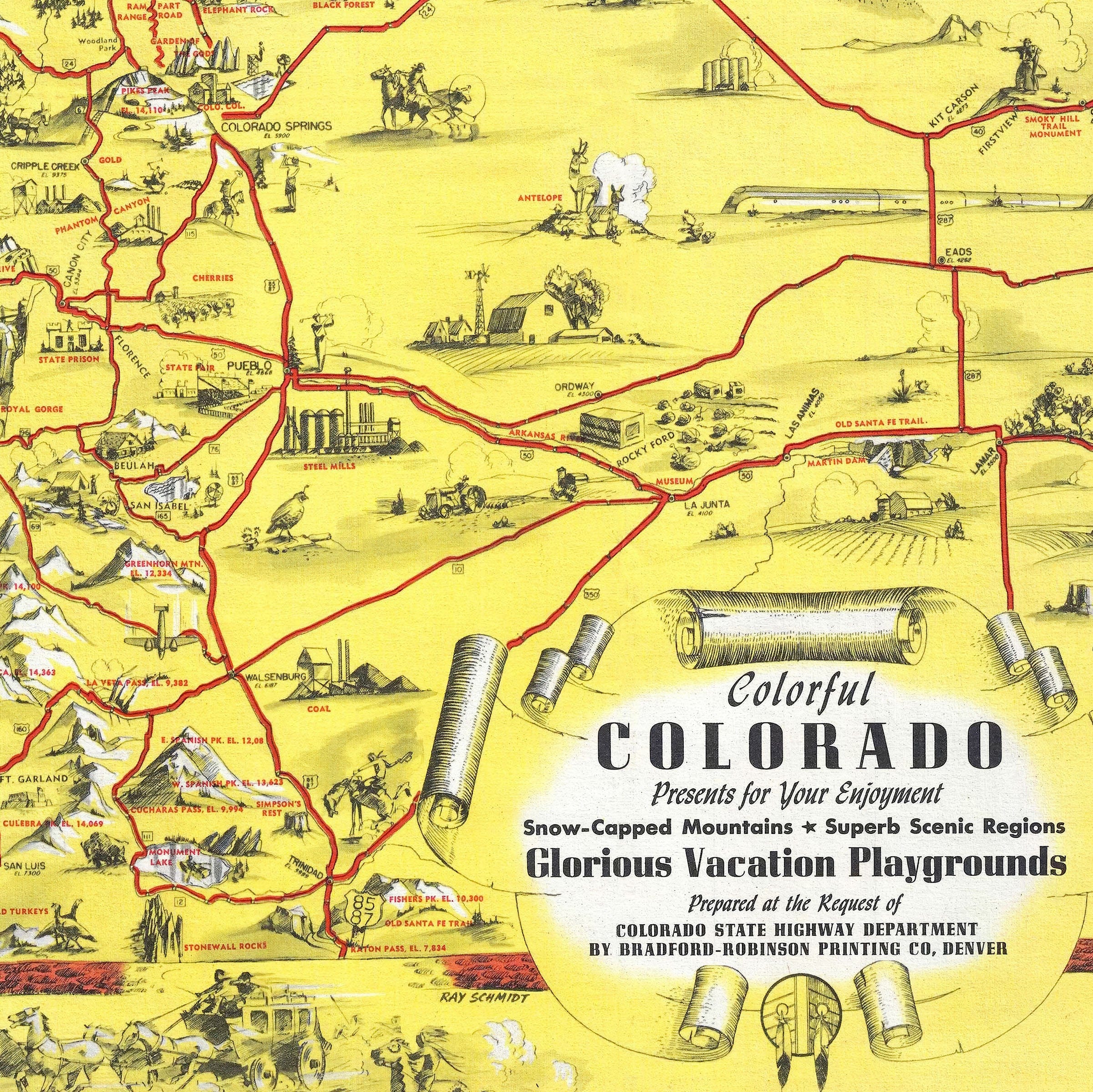
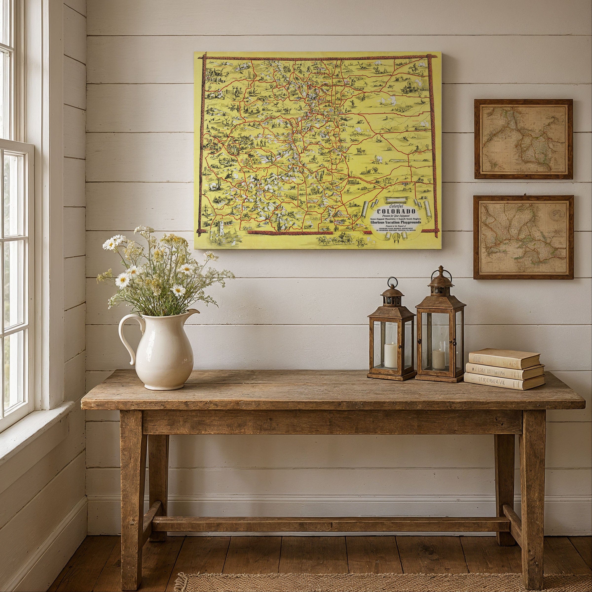
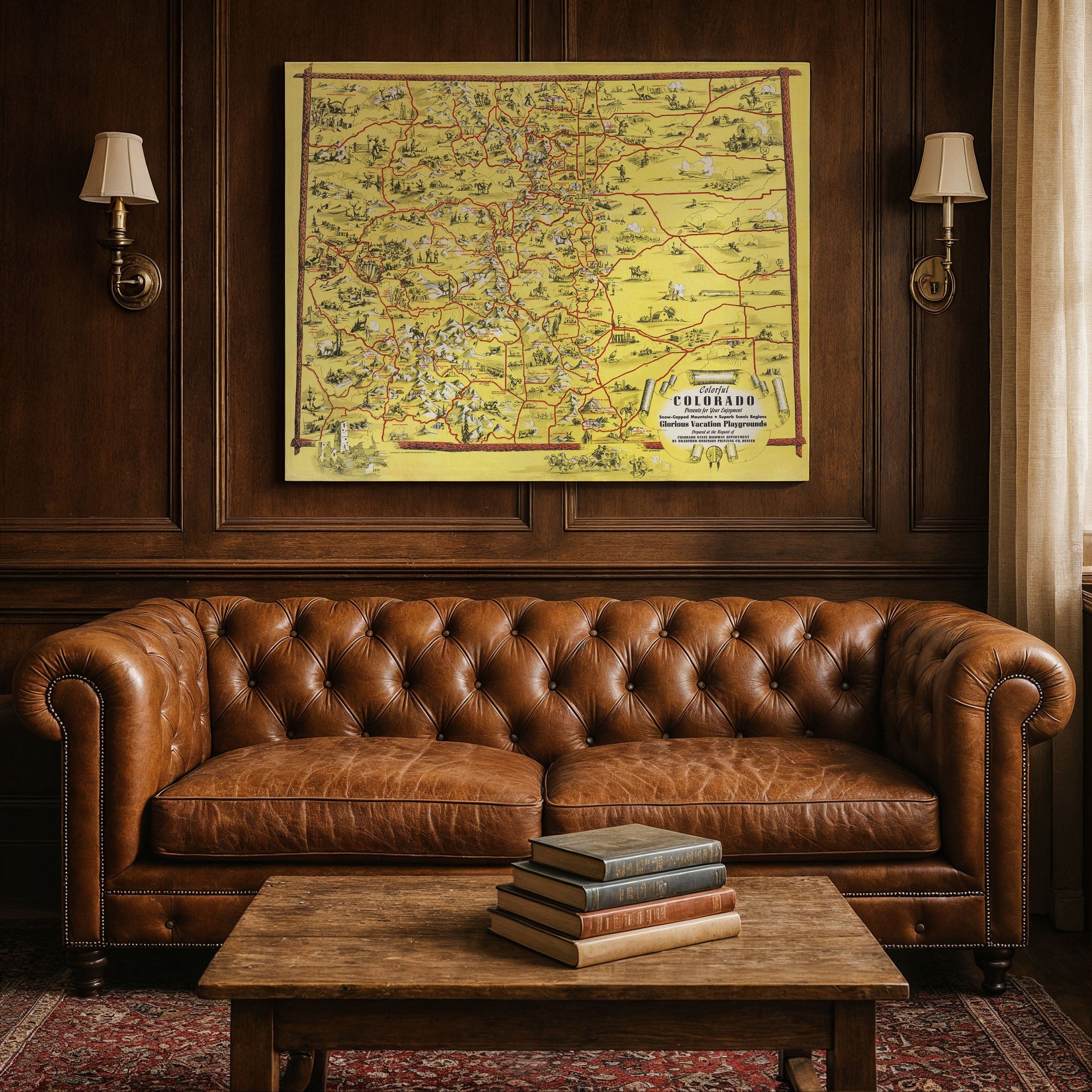
In 1941, with the country still feeling the ripples of the Great Depression and on the cusp of war, Colorado stood as a land of contrast—mountain grandeur, sweeping plains, and communities forging identity between past and future. The Colorful Colorado Presents for Your Enjoyment Snow-Capped Mountains – Superb Scenic Regions – Glorious Vacation Playgrounds pictorial map, created by Ray Schmidt and printed by the Bradford-Robinson Printing Company for the Colorado State Highway Department, is more than a travel poster. It’s a visual manifesto of Colorado’s promise and pride.
Schmidt’s map stretches from Utah’s red canyons to Kansas’s plains, from Wyoming’s high ridges to New Mexico’s mesas. Across this geography he scatters vignettes full of life. One moment you see covered wagons, cowboys, and prospectors; the next you spot modern cars, airplanes, and highways. In the lower left, Cliff House at Mesa Verde hints at ancient heritage. In the upper corner, a giant dinosaur marks Dinosaur National Monument. Wildlife—bighorn sheep, elk, deer, beaver—roam in stylized beauty. Cities like Denver, Colorado Springs, Durango, Pueblo, and Grand Junction are labeled and illustrated—Denver even gets a sketch of the Capitol building.
The map weaves stories in symbols. The mountains are not background—they are characters. Passes and peaks are named and annotated. Rivers and valleys shape the lines of roads and routes. The highways, new and bold, carve paths across the mapped land, promising connection, tourism, and commerce. It is a state both rooted and reaching.
The tension in 1941 was real. The United States had not yet entered World War II, but global conflict colored the air. Colorado’s citizens lived in the shadow of economic recovery and the uncertain horizon of war. At home, highways and tourism were lifelines—visitors from out of state brought revenue, and state leaders pushed road building as investment in infrastructure and identity.
Schmidt’s map embraces that tension. It shows both heritage—mining, westernness, frontier—and modernity—cars, aviation, highways, growth. It invites the viewer to trace routes, dream travels, and see Colorado not only as landscape, but as destination.
Viewed today, the 1941 map is a tapestry of ambition, nostalgia, and invitation. It recalls a moment when Colorado was asserting its identity to the nation. In its vignettes, routes, and bold mountain forms lies the belief that this state is not merely to be traversed—but to be experienced, celebrated, and claimed as home.
Materials
Choose options

Because every place has a story
Make History Personal
A vintage map is more than art.
It is a reminder of where life began.
Where memories were made.
Where hearts still live. Give the gift of place.
Beautifully preserved and made for the moments that matter.
Why Choose Us?
| Feature | Us | Competitor A | Competitor B |
|---|---|---|---|
| Hand Crafted | |||
| Museum Quality | |||
| 100 Year Guarantee | |||
| Restored by Hand | |||
| Certificate of Authenticity |

Art Prints
Archival quality colors. Best option if you'd like to frame it yourself

The Best Materials
We hand-stretched our canvas on solid American-grown pine stretcher bars. We use quality canvas and fade-resistant inks to create the lasting art. Canvases come with hardware already installed and ready to hang.
Need help?
Frequently Asked Questions
Order
All of our maps are meticulously restored reproductions of historic originals. Each piece is digitally repaired and color-corrected to bring out the finest details while preserving its authentic, vintage character.
Yes. All Archive Prints products are printed to order in the USA with archival materials.
We offer two premium formats:
- High-Quality Paper Posters – Printed on thick, archival-grade matte paper for rich, vibrant detail.
- Hand-Stretched Canvas Prints – Printed on premium polycotton canvas and mounted on 1.5" solid American pine stretcher bars for a gallery-quality finish.
We carefully digitally restore each map to enhance clarity and color while preserving its original look and historic charm. You’ll enjoy sharp details and a timeless vintage aesthetic that feels true to the original piece.
Yes, we do! We offer premium framing options to make your map ready to hang the moment it arrives. You can choose from Oak, Maple, Black, or Walnut frames directly on the product page. We also offer Stretched Canvas prints for a modern gallery look, as well as archival-quality Posters if you prefer to frame it yourself.
Yes! We offer free shipping on all products within the United States. Each map is carefully packaged to ensure it arrives in perfect condition.
If you’re not completely satisfied, you can return your order in new condition for a full refund. Return shipping costs are the responsibility of the customer.
Absolutely! Our maps make thoughtful, one-of-a-kind gifts for history lovers, map collectors, or anyone looking to add vintage character to their home or office. Choose between paper prints for framing or stretched canvas for a ready-to-hang presentation.
- Paper Posters → Shipped in durable, protective tubes to prevent creasing.
- Canvas Prints → Carefully wrapped, padded, and boxed to ensure safe delivery.
Our maps look stunning in a variety of settings, including:
- Living rooms and home offices
- Libraries and studies
- Corporate offices and conference rooms
- Restaurants, cafes, and boutique spaces