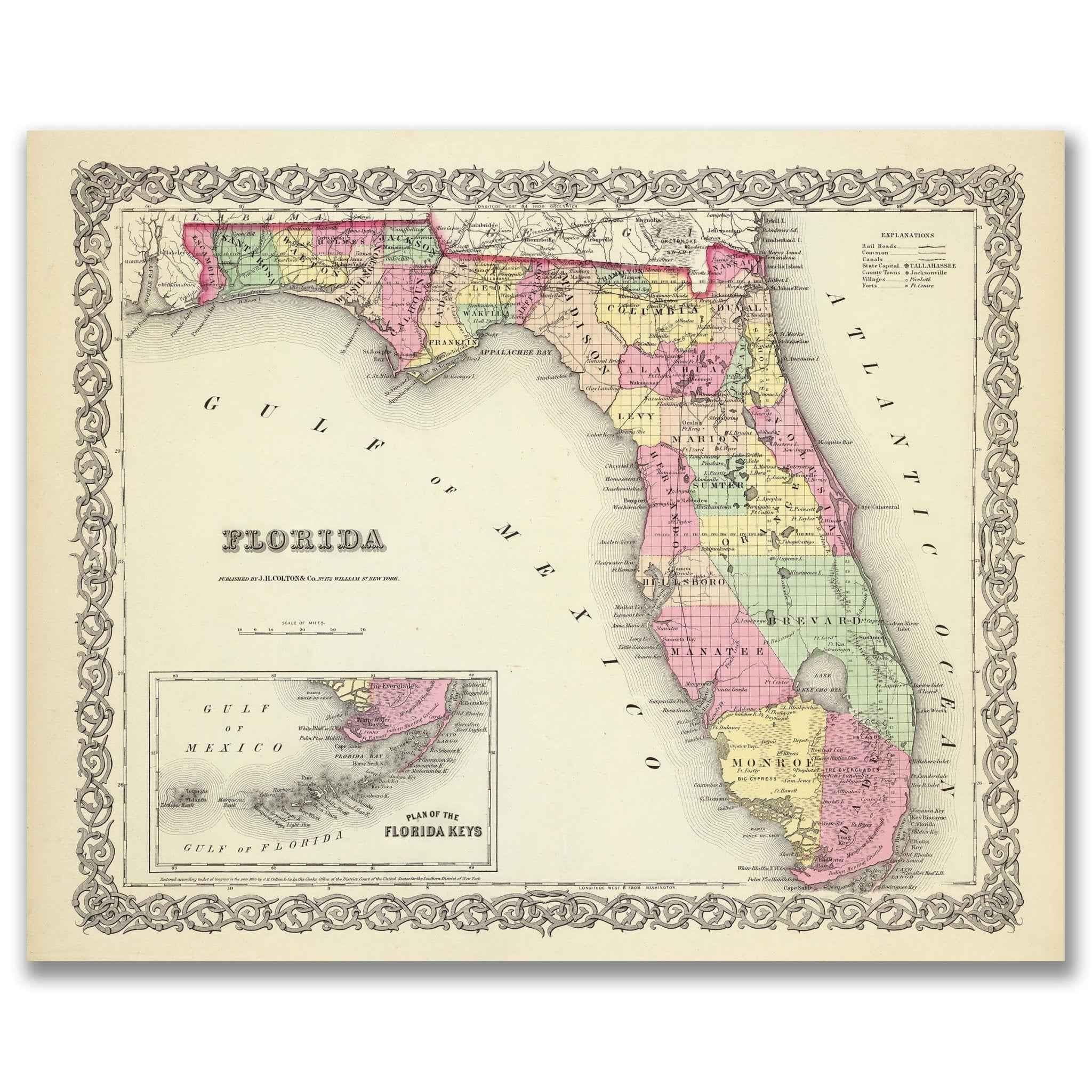
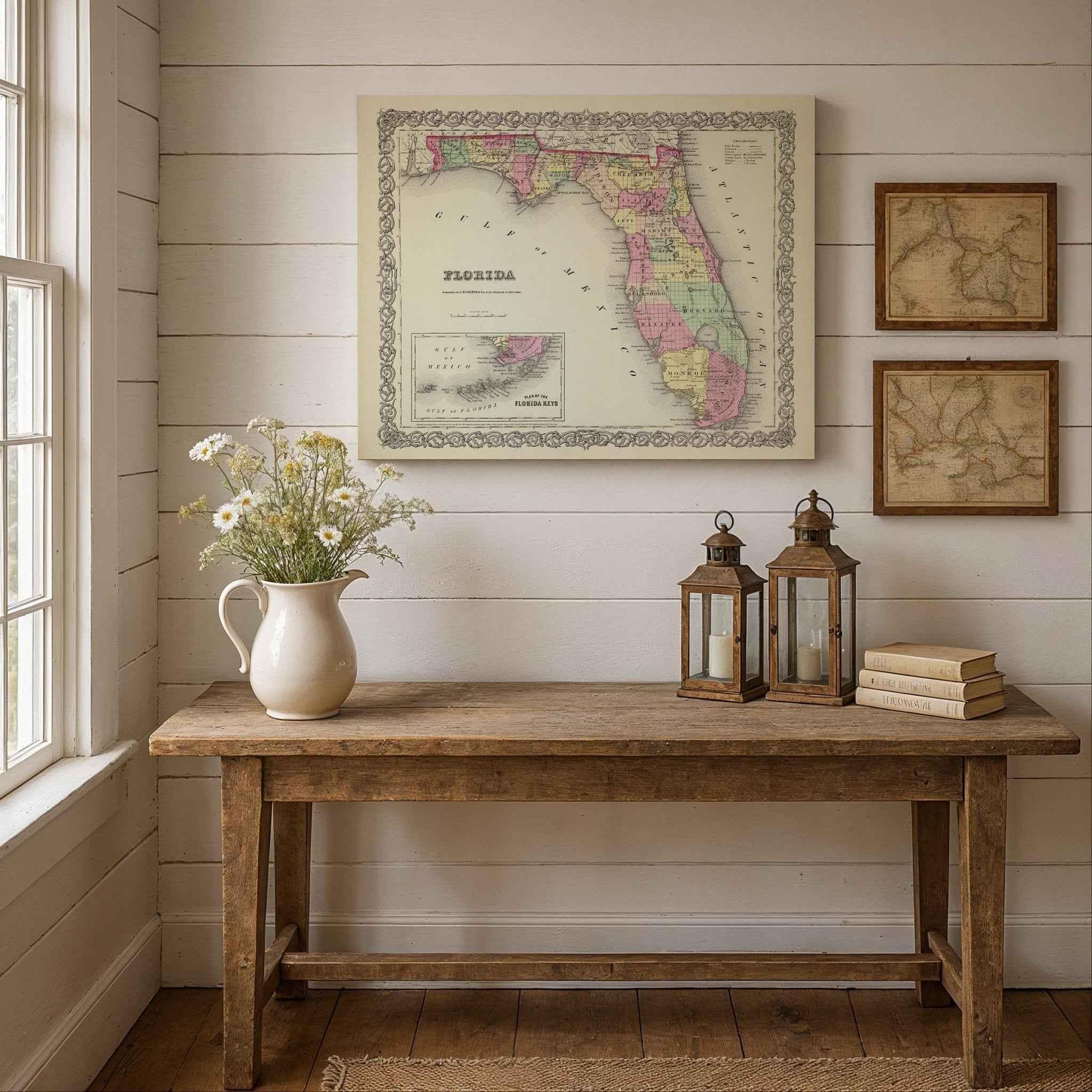
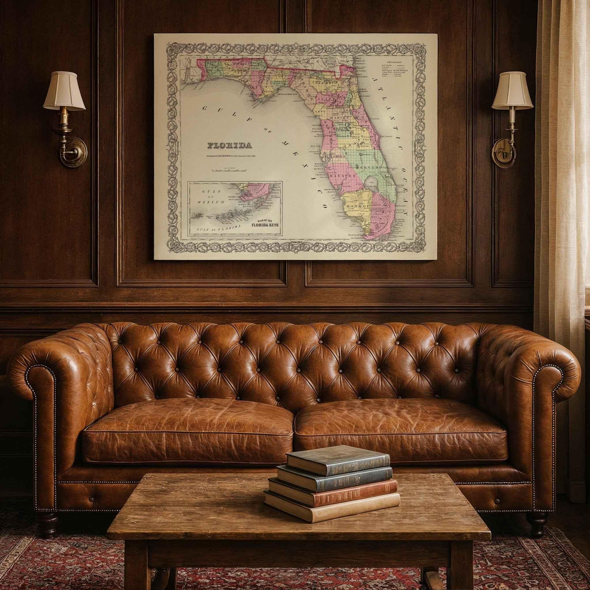
1856 Florida Map by G.W. Colton - Restored Vintage Wall Art Featuring Florida Keys Inset
Florida Map
Step back into the mid-19th century Florida Map and experience Florida as it once was with this beautifully restored 1856 G.W. Colton Map of Florida. Originally published by J.H. Colton & Co. in Colton’s Atlas of the World, this rare map captures the state just over a decade after its admission to the Union, complete with a detailed inset of the Florida Keys that highlights the importance of this maritime corridor.
Each reproduction includes a custom historical letter telling the story behind the map, making it the perfect gift for collectors, history lovers, and anyone who appreciates the heritage of the Sunshine State. Printed on heavyweight archival paper or premium polycotton canvas, every county line, river, and settlement is preserved in ultra-high-definition clarity thanks to our meticulous digital restoration process.
To ensure your map arrives safely, paper prints are carefully rolled in a sturdy cardboard mailing tube, while canvases ship in reinforced boxes for maximum protection. From presentation to preservation, every detail is crafted with care.
Bring home more than wall art. Bring home a story, a conversation piece, and a striking centerpiece that celebrates the enduring history of Florida.
The Map Story
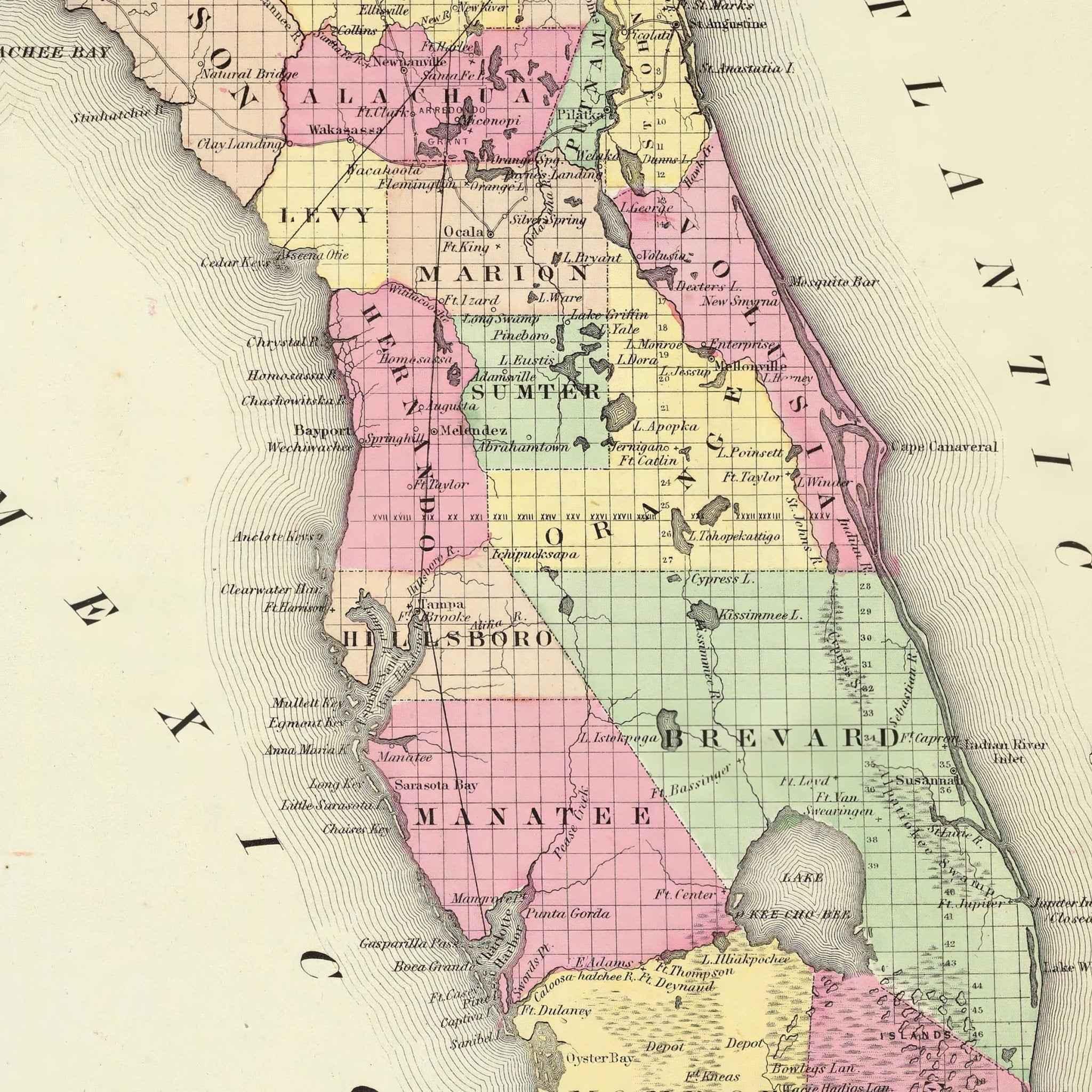
Florida’s Atlantic seaboard carried the promise of commerce, with harbors supporting a growing trade in lumber, citrus, and other agricultural goods. Along the Gulf Coast, bays and inlets served as lifelines for fishing and shipping, connecting isolated communities to wider markets. Inland, small towns and farms appeared along rivers, while survey lines hinted at the push to settle and organize new counties. The map presents a landscape still sparsely populated, yet alive with opportunity.
One of the most striking details is the inset of the Florida Keys. Stretching like a necklace into the sea, the Keys had already become a critical maritime corridor. Pilots, sailors, and traders learned its shallow waters, reefs, and channels with precision, knowing that mastery of these routes meant safer passage between the Gulf of Mexico and the Atlantic. The Keys not only connected Florida to Caribbean trade but also gave the state a distinct cultural and geographic identity.
The map also reveals Florida’s rivers as highways of the 19th century. The St. Johns flows northward, carrying timber and crops toward ports, while the Suwannee, Apalachicola, and other rivers link interior communities to the coast. Early railroads and stage routes appear as fine lines, evidence of the infrastructure beginning to spread. Some towns marked on the map would flourish into cities, while others would vanish or be renamed, leaving behind only cartographic traces.
Beyond geography, the artistry of the map deserves notice. The ornate border frames the peninsula like a work of decorative art, a hallmark of Colton’s atlas production. Every engraving reflects precision, from the sweep of the coastline to the delicate placement of towns. More than a navigational tool, it was a piece of craftsmanship, meant to be as visually compelling as it was informative.
Today, this 1856 map endures as a record of Florida at a formative stage. It captures a peninsula shaped by water and defined by its place between seas, still young as a state yet already integral to the nation’s growth. It invites us to imagine a Florida on the cusp of change, where rivers, coasts, and islands framed the lives of its people. This restored reproduction allows us to hold that moment in time—part art, part history, and part story of a state rising along America’s southern frontier.
Materials
Hand‑Stretched Canvas: If you choose canvas, we use a premium cotton‑poly blend stretched over solid pine frames. Each canvas is carefully hand‑stretched for a tight, gallery‑quality finish that’s ready to hang right out of the box.
Vivid, Fade‑Resistant Inks: We use professional‑grade inks that are UV‑resistant, so your print retains its rich colors even when displayed in bright rooms.
Expert Restoration: Every map is digitally restored by skilled artisans. We preserve the character of the original while enhancing clarity, so you see the map as it was meant to be seen.
Secure Packaging: Paper prints are rolled in heavy‑duty mailing tubes, and canvases are cushioned in reinforced boxes to ensure they arrive in pristine condition.
Choosing one of our prints means investing in craftsmanship. We combine historical authenticity with modern print technology and premium materials, giving you a work of art built to stand the test of time.
Choose options

Because every place has a story
Make History Personal
A vintage map is more than art.
It is a reminder of where life began.
Where memories were made.
Where hearts still live. Give the gift of place.
Beautifully preserved and made for the moments that matter.
Why Choose Us?
| Feature | Us | Competitor A | Competitor B |
|---|---|---|---|
| Hand Crafted | |||
| Museum Quality | |||
| 100 Year Guarantee | |||
| Restored by Hand | |||
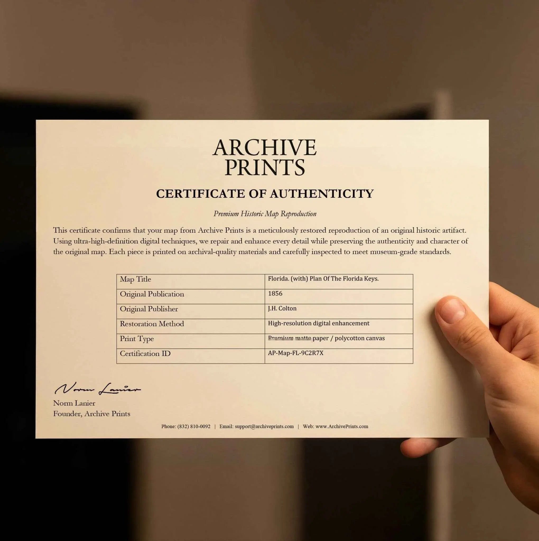
| Certificate of Authenticity |

Art Prints
Archival quality colors. Best option if you'd like to frame it yourself

The Best Materials
We hand-stretched our canvas on solid American-grown pine stretcher bars. We use quality canvas and fade-resistant inks to create the lasting art. Canvases come with hardware already installed and ready to hang.
Need help?
Frequently Asked Questions
Order
All of our maps are meticulously restored reproductions of historic originals. Each piece is digitally repaired and color-corrected to bring out the finest details while preserving its authentic, vintage character.
Yes. All Archive Prints products are printed to order in the USA with archival materials.
We offer two premium formats:
- High-Quality Paper Posters – Printed on thick, archival-grade matte paper for rich, vibrant detail.
- Hand-Stretched Canvas Prints – Printed on premium polycotton canvas and mounted on 1.5" solid American pine stretcher bars for a gallery-quality finish.
We carefully digitally restore each map to enhance clarity and color while preserving its original look and historic charm. You’ll enjoy sharp details and a timeless vintage aesthetic that feels true to the original piece.
Yes, we do! We offer premium framing options to make your map ready to hang the moment it arrives. You can choose from Oak, Maple, Black, or Walnut frames directly on the product page. We also offer Stretched Canvas prints for a modern gallery look, as well as archival-quality Posters if you prefer to frame it yourself.
Yes! We offer free shipping on all products within the United States. Each map is carefully packaged to ensure it arrives in perfect condition.
If you’re not completely satisfied, you can return your order in new condition for a full refund. Return shipping costs are the responsibility of the customer.
Absolutely! Our maps make thoughtful, one-of-a-kind gifts for history lovers, map collectors, or anyone looking to add vintage character to their home or office. Choose between paper prints for framing or stretched canvas for a ready-to-hang presentation.
- Paper Posters → Shipped in durable, protective tubes to prevent creasing.
- Canvas Prints → Carefully wrapped, padded, and boxed to ensure safe delivery.
Our maps look stunning in a variety of settings, including:
- Living rooms and home offices
- Libraries and studies
- Corporate offices and conference rooms
- Restaurants, cafes, and boutique spaces