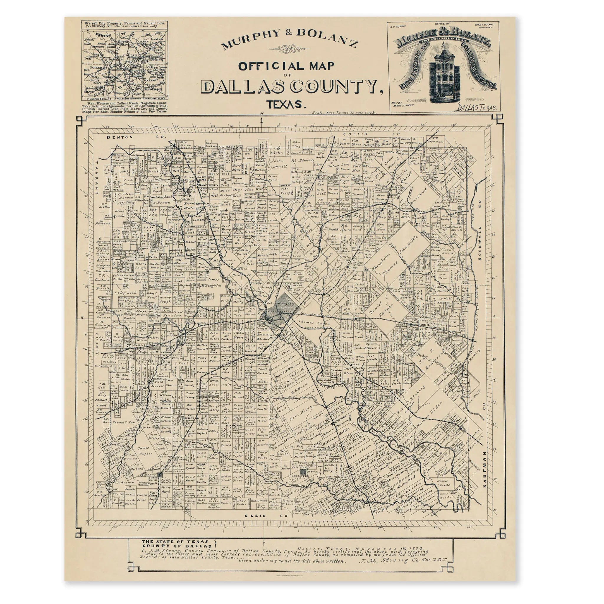
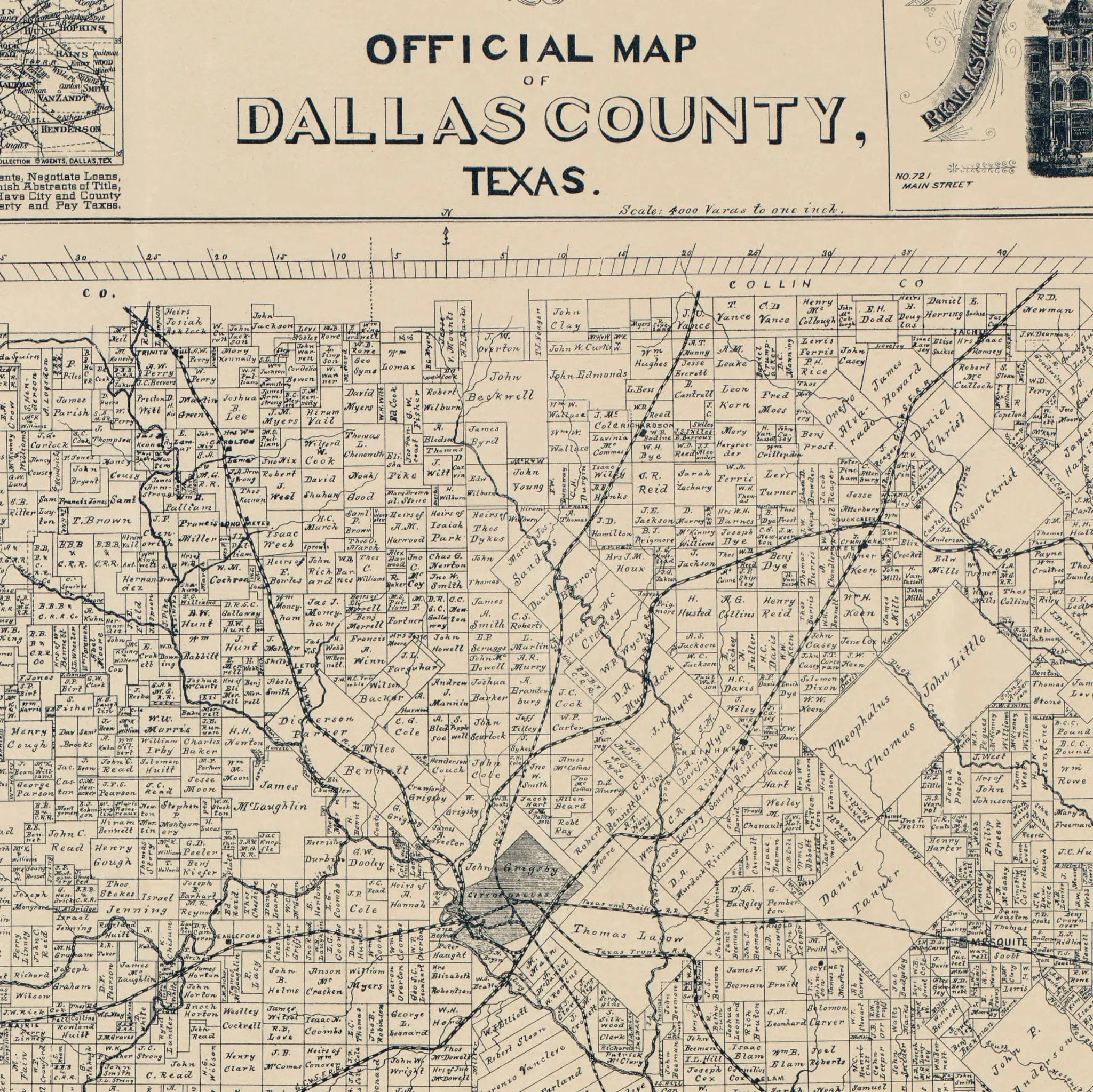
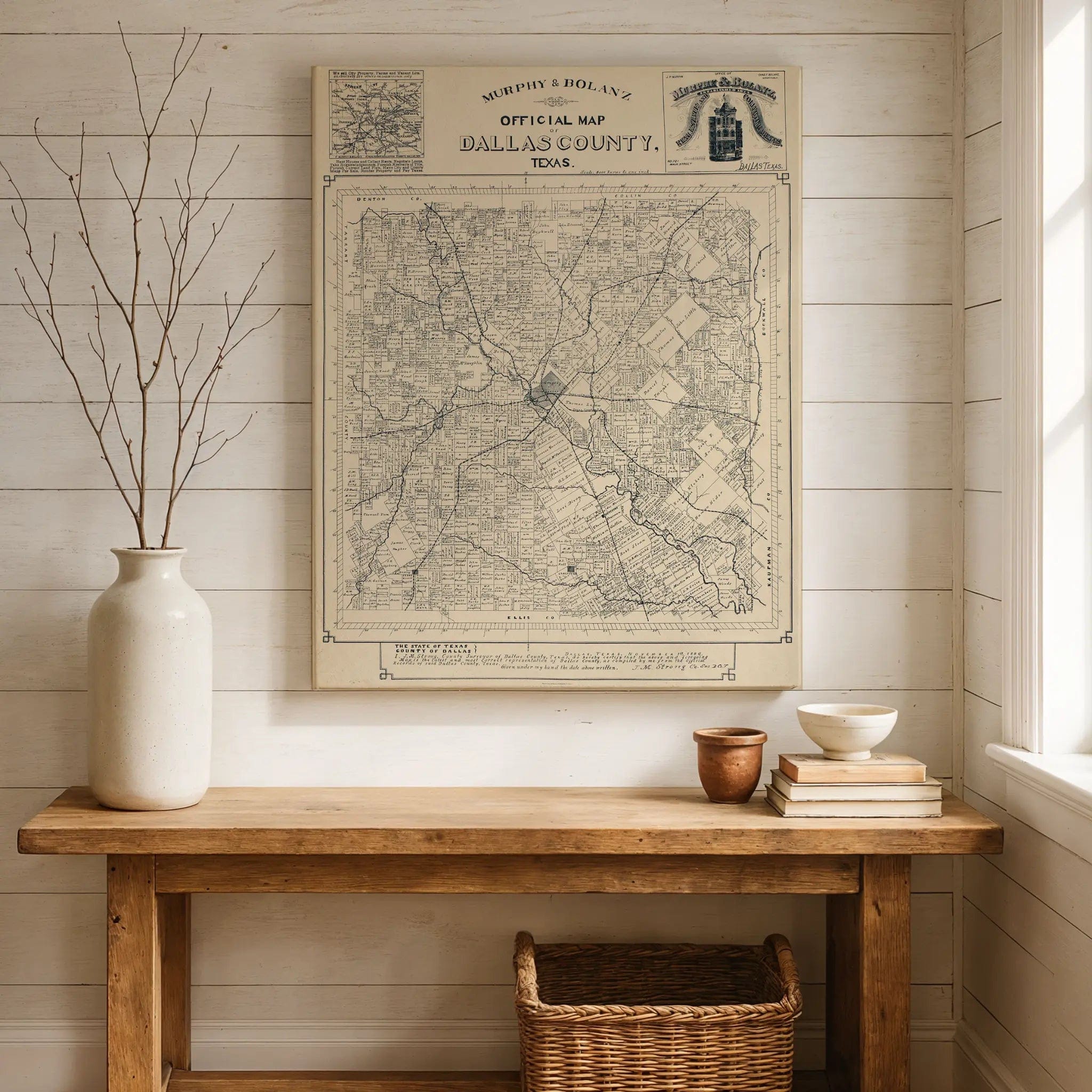
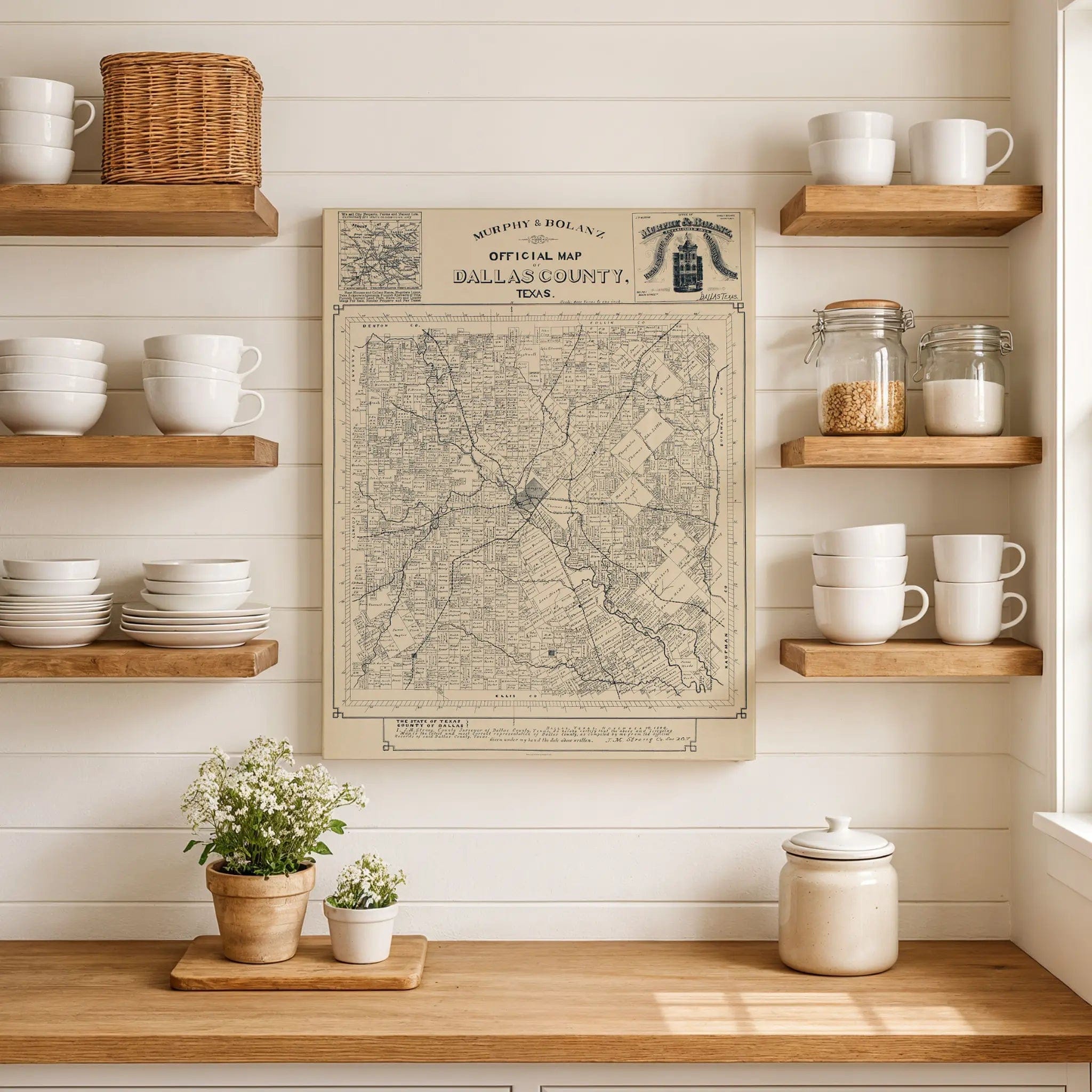

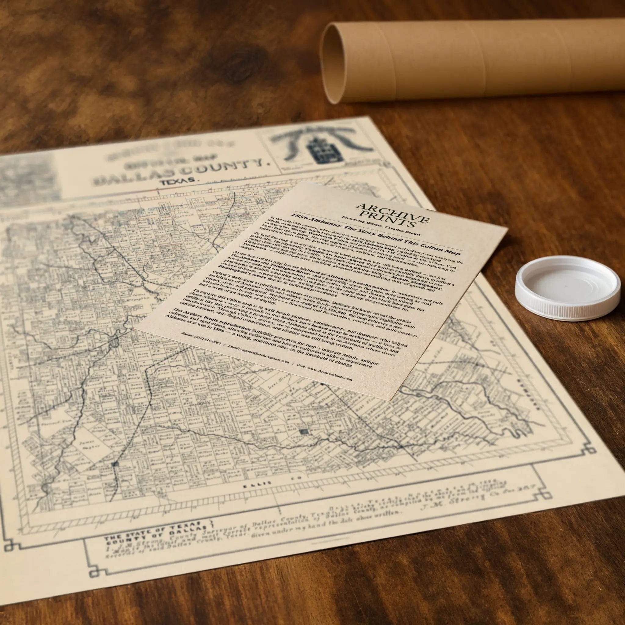
Dallas County Vintage Map 1886 by Murphy & Bolanz - Official Historical Print
Discover Dallas County in the Gilded Age of Texas Step back into the dynamic 1880s with this beautifully restored 1886 Dallas County Map, published by the renowned Dallas surveyors Murphy & Bolanz. Created at a time when Dallas was rapidly evolving from a frontier settlement into one of Texas’s most ambitious urban centers, this map captures the region in stunning detail—its townships, creeks, and railroads woven into a portrait of transformation and opportunity. Produced for surveyors, developers, and land investors, the 1886 map documents a county on the rise. Every township and land grant is carefully labeled, reflecting the meticulous surveying and recordkeeping that guided Dallas’s explosive growth. The winding courses of the Trinity River and its tributaries cut through the page, anchoring a landscape now alive with new roads, rail lines, and settlements. At the heart of the map lies the city of Dallas, its expanding street grid signaling a community fast becoming a hub of trade and progress. Just decades after the arrival of the railroads, Dallas had become the commercial pulse of North Texas—its cotton markets, factories, and rail yards driving prosperity that reached far beyond the city limits. Surrounding the city, once-vast ranchlands are now divided into tidy tracts, each marked by surveyor’s lines that tell the story of settlement and speculation. More than a map, this was a statement of confidence—a promise that Dallas County’s future would be written in the language of expansion. Today, it serves as a historical touchstone, linking the modern skyline with the county’s rural roots and showing how vision and geography shaped a region that would soon lead the state in commerce and innovation. Each reproduction includes a custom historical letter detailing the map’s origins and context, making it a perfect addition for collectors, historians, and proud Texans alike. Printed with precision on heavyweight archival paper or hand-stretched premium canvas, every boundary line, river bend, and rail corridor is restored with museum-grade clarity using state-of-the-art digital restoration techniques. Paper prints arrive rolled in durable mailing tubes, while canvas prints are gallery-wrapped on solid pine stretcher bars with pre-installed hardware—ready to hang and enjoy the moment it arrives. Bring home a piece of Texas history and experience Dallas County as it was in 1886—a place of bold ambition, open land, and limitless promise.
The Map Story
In 1886, Dallas stood at the threshold of transformation. Just a few decades earlier, it had been a quiet trading post on the Trinity River. By the mid-1880s, the arrival of multiple railroads had turned it into one of the fastest-growing cities in Texas—a crossroads of commerce linking the plains to the ports of the Gulf.
Cotton drove the economy. The surrounding countryside was dotted with gins and warehouses, and railcars left the city loaded with bales bound for distant mills. The railroads brought not only trade but people: farmers seeking better markets, merchants chasing opportunity, and families escaping the hard years that followed the Civil War. With each new arrival, Dallas became less of a frontier town and more of a regional capital.
The city was alive with construction. Brick replaced wood, and the first multi-story buildings began to rise downtown. Streets filled with streetcars and wagons, and telegraph wires laced the skyline. Gas lamps illuminated the main thoroughfares, signaling Dallas’s embrace of modernity. Civic leaders boasted of their schools, churches, and new courthouse, while newspapers predicted that the city would soon rival St. Louis or New Orleans in influence.
Still, the frontier was never far away. Beyond the city limits stretched open prairie—vast tracts of farmland crisscrossed by creeks, fences, and wagon trails. Surveyors and land agents divided the land into neat parcels, selling off the future acre by acre. Land speculation became a kind of fever, fueled by confidence that Dallas would continue to grow without limit.
Life in 1886 was a blend of grit and optimism. Cattlemen and bankers, laborers and lawyers, all moved through the same muddy streets, united by ambition and faith in the city’s destiny. The wounds of the Civil War had not fully healed, yet Dallas looked forward with determination rather than backward in grief.
This was the Dallas captured in the maps of the era—a place where fields met rail lines, where visionaries saw a metropolis waiting to emerge from the prairie. The Dallas of 1886 was not yet the modern city it would become, but its foundations were already in place: industry, transportation, and a restless belief that anything was possible in North Texas.
Materials
Hand‑Stretched Canvas: If you choose canvas, we use a premium cotton‑poly blend stretched over solid pine frames. Each canvas is carefully hand‑stretched for a tight, gallery‑quality finish that's ready to hang right out of the box.
Vivid, Fade‑Resistant Inks: We use professional‑grade inks that are UV‑resistant, so your print retains its rich colors even when displayed in bright rooms.
Expert Restoration: Every map is digitally restored by skilled artisans. We preserve the character of the original while enhancing clarity, so you see the map as it was meant to be seen.
Secure Packaging: Paper prints are rolled in heavy‑duty mailing tubes, and canvases are cushioned in reinforced boxes to ensure they arrive in pristine condition.
Choosing one of our prints means investing in craftsmanship. We combine historical authenticity with modern print technology and premium materials, giving you a work of art built to stand the test of time.
Choose options

Because every place has a story
Make History Personal
A vintage map is more than art.
It is a reminder of where life began.
Where memories were made.
Where hearts still live. Give the gift of place.
Beautifully preserved and made for the moments that matter.
Why Choose Us?
| Feature | Us | Competitor A | Competitor B |
|---|---|---|---|
| Hand Crafted | |||
| Museum Quality | |||
| 100 Year Guarantee | |||
| Restored by Hand | |||
| Certificate of Authenticity |

Art Prints
Archival quality colors. Best option if you'd like to frame it yourself

The Best Materials
We hand-stretched our canvas on solid American-grown pine stretcher bars. We use quality canvas and fade-resistant inks to create the lasting art. Canvases come with hardware already installed and ready to hang.
Need help?
Frequently Asked Questions
Order
All of our maps are meticulously restored reproductions of historic originals. Each piece is digitally repaired and color-corrected to bring out the finest details while preserving its authentic, vintage character.
Yes. All Archive Prints products are printed to order in the USA with archival materials.
We offer two premium formats:
- High-Quality Paper Posters – Printed on thick, archival-grade matte paper for rich, vibrant detail.
- Hand-Stretched Canvas Prints – Printed on premium polycotton canvas and mounted on 1.5" solid American pine stretcher bars for a gallery-quality finish.
We carefully digitally restore each map to enhance clarity and color while preserving its original look and historic charm. You’ll enjoy sharp details and a timeless vintage aesthetic that feels true to the original piece.
Yes, we do! We offer premium framing options to make your map ready to hang the moment it arrives. You can choose from Oak, Maple, Black, or Walnut frames directly on the product page. We also offer Stretched Canvas prints for a modern gallery look, as well as archival-quality Posters if you prefer to frame it yourself.
Yes! We offer free shipping on all products within the United States. Each map is carefully packaged to ensure it arrives in perfect condition.
If you’re not completely satisfied, you can return your order in new condition for a full refund. Return shipping costs are the responsibility of the customer.
Absolutely! Our maps make thoughtful, one-of-a-kind gifts for history lovers, map collectors, or anyone looking to add vintage character to their home or office. Choose between paper prints for framing or stretched canvas for a ready-to-hang presentation.
- Paper Posters → Shipped in durable, protective tubes to prevent creasing.
- Canvas Prints → Carefully wrapped, padded, and boxed to ensure safe delivery.
Our maps look stunning in a variety of settings, including:
- Living rooms and home offices
- Libraries and studies
- Corporate offices and conference rooms
- Restaurants, cafes, and boutique spaces