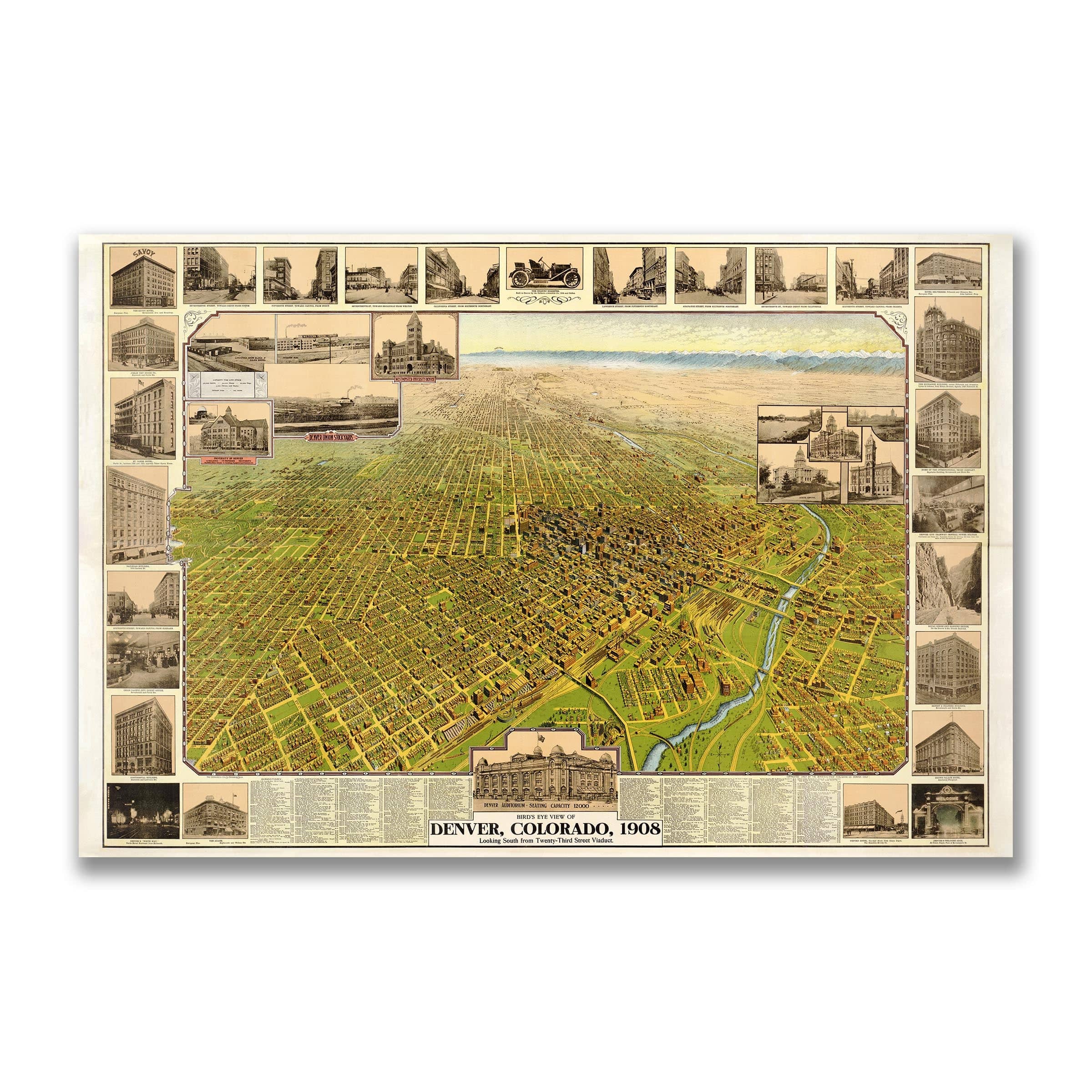


Denver Vintage Bird's-Eye Map - 1908 Colorado Historical City Map
Denver Vintage Bird's-Eye Map
Discover Denver in Its Pictorial Prime Explore the vibrant energy and urban ambition of Denver with this meticulously restored 1908 Bird’s-Eye Map of Denver, Colorado, originally published by the Birdseye View Publishing Co. in partnership with the Denver Lithograph Co.. This remarkable piece captures the Mile-High City during a pivotal era—when Denver was shedding its frontier past and asserting itself as the gateway to the West. digital.denverlibrary.org +2 Archive Prints +2 Created at a moment when railroads, industry, and elevation (exactly one mile above sea level) shaped Denver’s identity, the map presents a city in full stride. The broad boulevards of downtown radiate with purpose, streetcar lines mesh neighborhood to core, and the looming Rockies form a dramatic backdrop. The downtown grid pulses with architecture—hotel towers, civic halls, theaters—a testament to a city determined to be seen. This view isn’t solely about streets and buildings—it’s about ambition. The South Platte River winds quietly beneath the urban sprawl, whispering of a land once raw, now harnessed. Rail yards pulse with freight; the city’s layout reaches out toward the mountains, echoing the message: Denver is no more a way-station, but a destination. Each reproduction includes a custom historical letter detailing the map’s significance, making it ideal for collectors, urban historians, and anyone drawn to Denver’s rich heritage. Printed with precision on heavyweight archival paper or hand‐stretched premium canvas, every street, landmark, and line is brought to life with museum-grade clarity. Paper prints arrive rolled in sturdy mailing tubes; canvas prints arrive gallery-wrapped on solid pine stretcher bars with pre-installed hardware—ready to display the moment they arrive. Bring home a piece of Colorado history and celebrate Denver not just as it is today—but as it stood in 1908: poised between frontier and future, city and mountain, ambition and achievement.
The Map Story
In 1907, Denver stood at the height of transformation—no longer a rough mining town, but not yet the polished capital it longed to be. The gold rush was history, the railroads were built, and the Queen City of the Plains had turned its eyes toward permanence. This map captures Denver at that exact moment of confidence, its streets meticulously drawn, its neighborhoods spreading outward like ripples on water.
President Theodore Roosevelt was in the White House, preaching progress and conservation in equal measure. His Square Deal ideals—fairness, reform, and civic virtue—echoed across the growing city. Denver shared that spirit. Under the leadership of Governor Henry Augustus Buchtel, a former university chancellor turned politician, Colorado was embracing reform and order. Buchtel’s moral rigor matched Roosevelt’s national vision: cleaner government, better infrastructure, and a new civic pride.
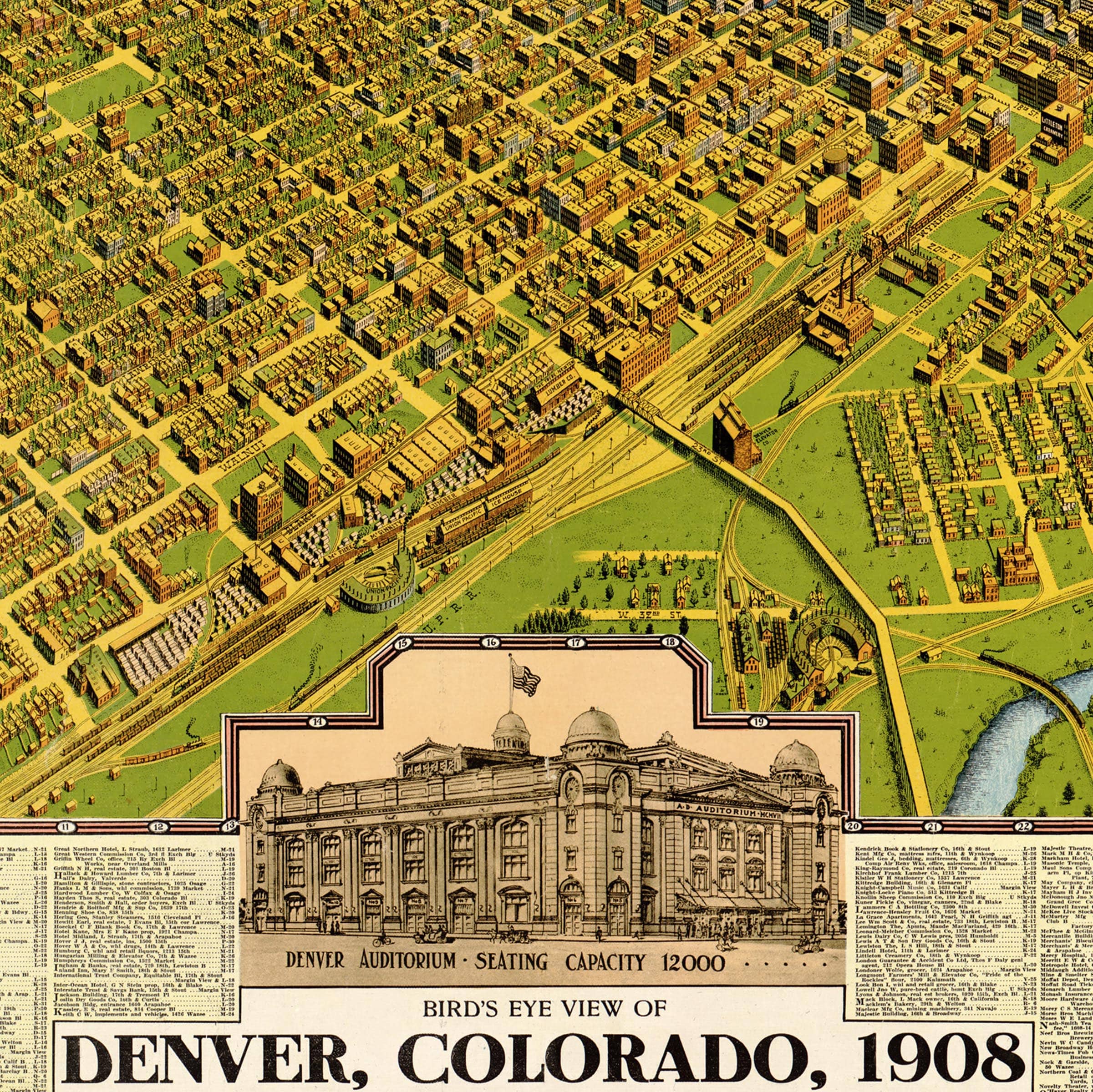
You can feel that pride in the map’s geometry. Grand avenues—Colfax, Broadway, Champa -stretch straight and purposeful. The downtown core hums with activity: the Brown Palace Hotel, Union Station, and the State Capitol standing like monuments to ambition. Trolley lines weave through the city, linking new suburbs to the commercial heart. Parks and boulevards, inspired by the City Beautiful movement, frame the landscape with optimism.
But not everything was elegant. Denver still carried traces of its rougher past—dusty edges, rail yards, and the remnants of boomtown neighborhoods. Smelters and stockyards puffed smoke in the distance. Immigrants worked long hours in rail shops and factories, while the city’s elite built mansions on Capitol Hill, symbols of refinement rising from grit.
Beneath it all ran a quiet tension: the city’s rapid growth against its natural limits. The South Platte River meandered through town, both lifeline and threat. Dust storms swept down from the plains. Yet the people of Denver believed in destiny. The 1907 map doesn’t just record a city—it celebrates an idea.
Denver had become the heart of the Mountain West, a crossroads of modern America. Every street line and contour on this map reflects the same conviction shared by Roosevelt and Buchtel alike—that progress was not a dream, but a duty.
Materials
Choose options

Because every place has a story
Make History Personal
A vintage map is more than art.
It is a reminder of where life began.
Where memories were made.
Where hearts still live. Give the gift of place.
Beautifully preserved and made for the moments that matter.
Why Choose Us?
| Feature | Us | Competitor A | Competitor B |
|---|---|---|---|
| Hand Crafted | |||
| Museum Quality | |||
| 100 Year Guarantee | |||
| Restored by Hand | |||
| Certificate of Authenticity |

Art Prints
Archival quality colors. Best option if you'd like to frame it yourself

The Best Materials
We hand-stretched our canvas on solid American-grown pine stretcher bars. We use quality canvas and fade-resistant inks to create the lasting art. Canvases come with hardware already installed and ready to hang.
Need help?
Frequently Asked Questions
Order
All of our maps are meticulously restored reproductions of historic originals. Each piece is digitally repaired and color-corrected to bring out the finest details while preserving its authentic, vintage character.
Yes. All Archive Prints products are printed to order in the USA with archival materials.
We offer two premium formats:
- High-Quality Paper Posters – Printed on thick, archival-grade matte paper for rich, vibrant detail.
- Hand-Stretched Canvas Prints – Printed on premium polycotton canvas and mounted on 1.5" solid American pine stretcher bars for a gallery-quality finish.
We carefully digitally restore each map to enhance clarity and color while preserving its original look and historic charm. You’ll enjoy sharp details and a timeless vintage aesthetic that feels true to the original piece.
Yes, we do! We offer premium framing options to make your map ready to hang the moment it arrives. You can choose from Oak, Maple, Black, or Walnut frames directly on the product page. We also offer Stretched Canvas prints for a modern gallery look, as well as archival-quality Posters if you prefer to frame it yourself.
Yes! We offer free shipping on all products within the United States. Each map is carefully packaged to ensure it arrives in perfect condition.
If you’re not completely satisfied, you can return your order in new condition for a full refund. Return shipping costs are the responsibility of the customer.
Absolutely! Our maps make thoughtful, one-of-a-kind gifts for history lovers, map collectors, or anyone looking to add vintage character to their home or office. Choose between paper prints for framing or stretched canvas for a ready-to-hang presentation.
- Paper Posters → Shipped in durable, protective tubes to prevent creasing.
- Canvas Prints → Carefully wrapped, padded, and boxed to ensure safe delivery.
Our maps look stunning in a variety of settings, including:
- Living rooms and home offices
- Libraries and studies
- Corporate offices and conference rooms
- Restaurants, cafes, and boutique spaces