
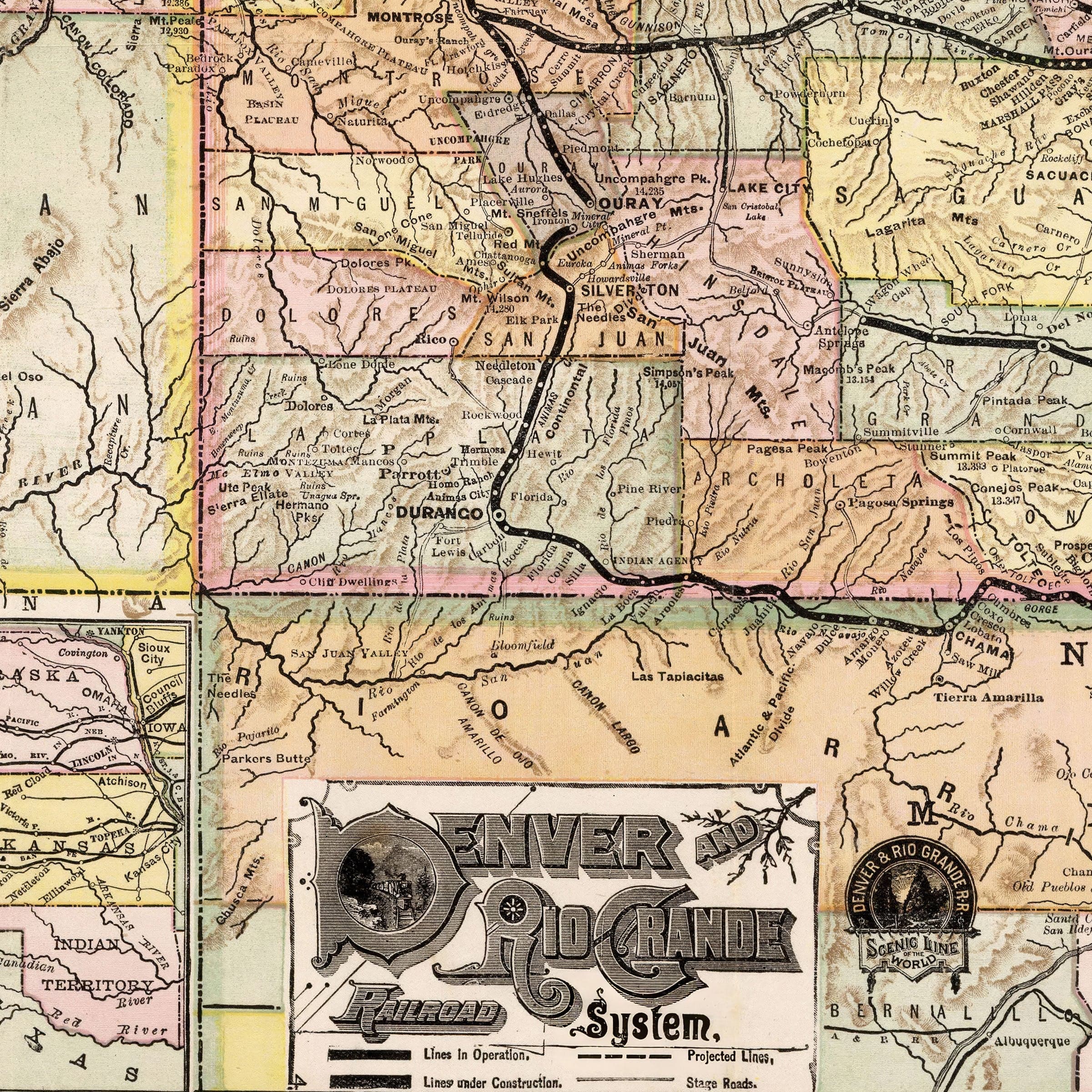


Denver and Rio Grande Railroad Map - Historic System Map from 1883
Discover the Rails That Built the Rockies
Travel back to 1883, when Colorado was alive with ambition and the American West was being bound together by steel. This meticulously restored Denver and Rio Grande Railroad System map, originally published by Rand McNally & Company of Chicago, captures a moment when engineering, exploration, and enterprise collided to transform the frontier into a connected world.
The Denver and Rio Grande proudly called itself the “Scenic Line of the World”—and this map proves why. Its sweeping rail lines carve boldly across the Rockies, threading through canyons, scaling high passes, and linking Denver with the booming mining towns of Leadville, Silverton, and Durango. Each route marks not only a path of travel but a triumph over isolation, bringing prosperity and people into regions once reachable only by stagecoach or trail.
In the vivid colors and fine engraving of this 1883 map, you can trace Colorado’s rapid evolution from a rugged territory into a thriving state. Railroads under construction hint at the future yet to come, while fading stage roads linger as ghosts of an older age. County lines, mountain ranges, and waterways are drawn with precision, showing how geography shaped every mile of progress.
This was a defining era for Colorado—a time when the railroad became the state’s lifeline. The Denver and Rio Grande carried ore from mountain mines, timber from high forests, cattle from open ranges, and settlers from the East. It wasn’t just a transportation network; it was the thread that stitched together farm and foundry, mountain and plain, wilderness and civilization.
Each reproduction includes a custom historical letter detailing the story behind the map, making it perfect for collectors, historians, and railroad enthusiasts. Printed on heavyweight archival paper or hand-stretched polycotton canvas, every track, contour, and county boundary is restored in museum-grade clarity for generations of enjoyment.
Paper prints ship rolled in heavy-duty tubes, while canvas editions arrive gallery-wrapped on solid pine stretcher bars with pre-installed hardware—ready to display the moment it arrives.
Bring home a piece of Colorado’s pioneering legacy and celebrate the bold vision that made the Rocky Mountains accessible to the world.
The Map Story
Materials
Choose options

Because every place has a story
Make History Personal
A vintage map is more than art.
It is a reminder of where life began.
Where memories were made.
Where hearts still live. Give the gift of place.
Beautifully preserved and made for the moments that matter.
Why Choose Us?
| Feature | Us | Competitor A | Competitor B |
|---|---|---|---|
| Hand Crafted | |||
| Museum Quality | |||
| 100 Year Guarantee | |||
| Restored by Hand | |||
| Certificate of Authenticity |

Art Prints
Archival quality colors. Best option if you'd like to frame it yourself

The Best Materials
We hand-stretched our canvas on solid American-grown pine stretcher bars. We use quality canvas and fade-resistant inks to create the lasting art. Canvases come with hardware already installed and ready to hang.
Need help?
Frequently Asked Questions
Order
All of our maps are meticulously restored reproductions of historic originals. Each piece is digitally repaired and color-corrected to bring out the finest details while preserving its authentic, vintage character.
Yes. All Archive Prints products are printed to order in the USA with archival materials.
We offer two premium formats:
- High-Quality Paper Posters – Printed on thick, archival-grade matte paper for rich, vibrant detail.
- Hand-Stretched Canvas Prints – Printed on premium polycotton canvas and mounted on 1.5" solid American pine stretcher bars for a gallery-quality finish.
We carefully digitally restore each map to enhance clarity and color while preserving its original look and historic charm. You’ll enjoy sharp details and a timeless vintage aesthetic that feels true to the original piece.
Yes, we do! We offer premium framing options to make your map ready to hang the moment it arrives. You can choose from Oak, Maple, Black, or Walnut frames directly on the product page. We also offer Stretched Canvas prints for a modern gallery look, as well as archival-quality Posters if you prefer to frame it yourself.
Yes! We offer free shipping on all products within the United States. Each map is carefully packaged to ensure it arrives in perfect condition.
If you’re not completely satisfied, you can return your order in new condition for a full refund. Return shipping costs are the responsibility of the customer.
Absolutely! Our maps make thoughtful, one-of-a-kind gifts for history lovers, map collectors, or anyone looking to add vintage character to their home or office. Choose between paper prints for framing or stretched canvas for a ready-to-hang presentation.
- Paper Posters → Shipped in durable, protective tubes to prevent creasing.
- Canvas Prints → Carefully wrapped, padded, and boxed to ensure safe delivery.
Our maps look stunning in a variety of settings, including:
- Living rooms and home offices
- Libraries and studies
- Corporate offices and conference rooms
- Restaurants, cafes, and boutique spaces