Erin's First Families The Story of Ireland's Lineage Map 1946
Erin's First Families The Story of Ireland's Lineage Map 1946
Discover 1946's captivating Erin's First Families The Story of Ireland's Lineage Map, a beautifully illustrated journey through Ireland's ancient heritage that traces the roots of the island's earliest clans and noble families. This isn't just a map—it's a cultural tapestry that charts not only geography but ancestry, memory, and belonging. Each county reveals the historic Gaelic families whose legacies shaped Irish identity across centuries, making this an essential piece for anyone with Irish roots or a love of Celtic history.
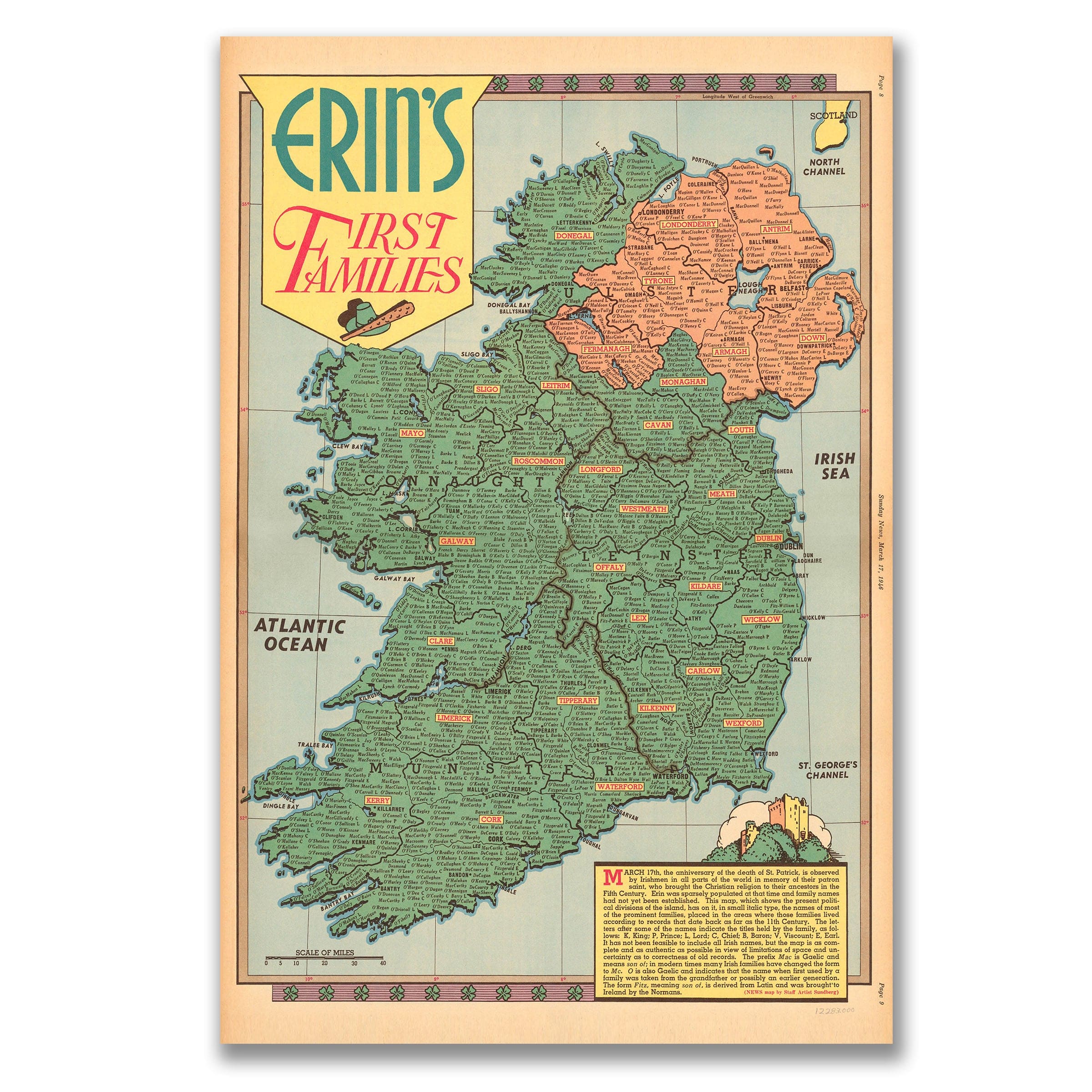
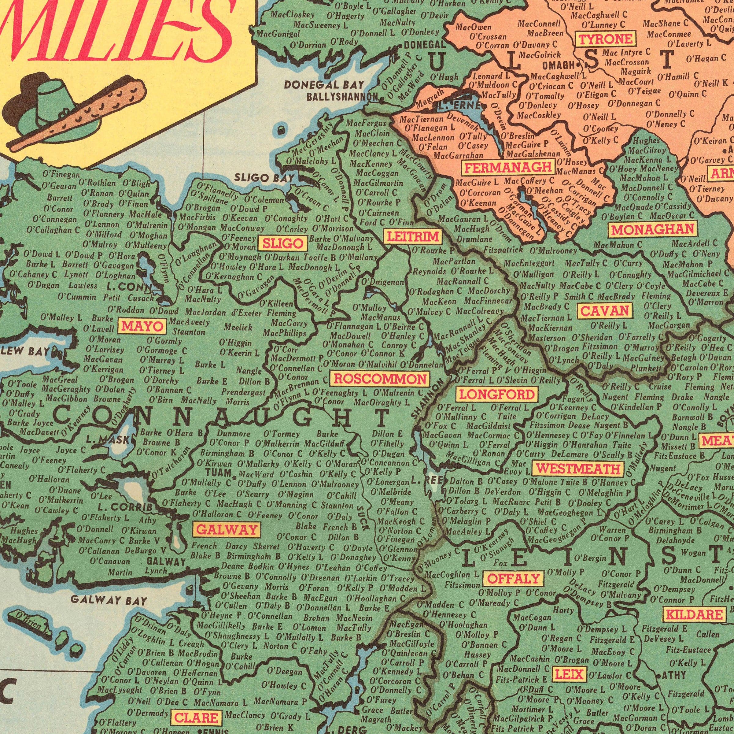
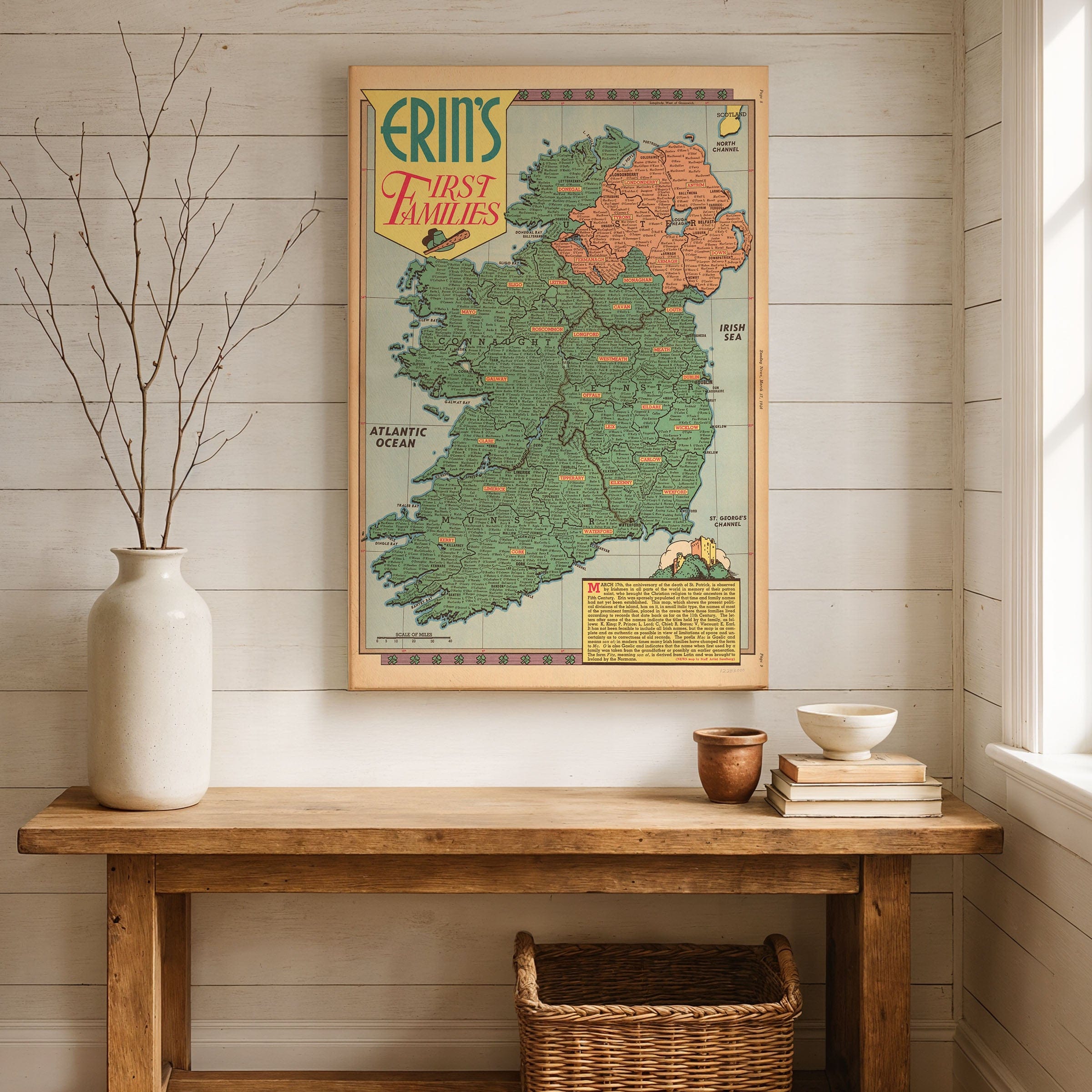
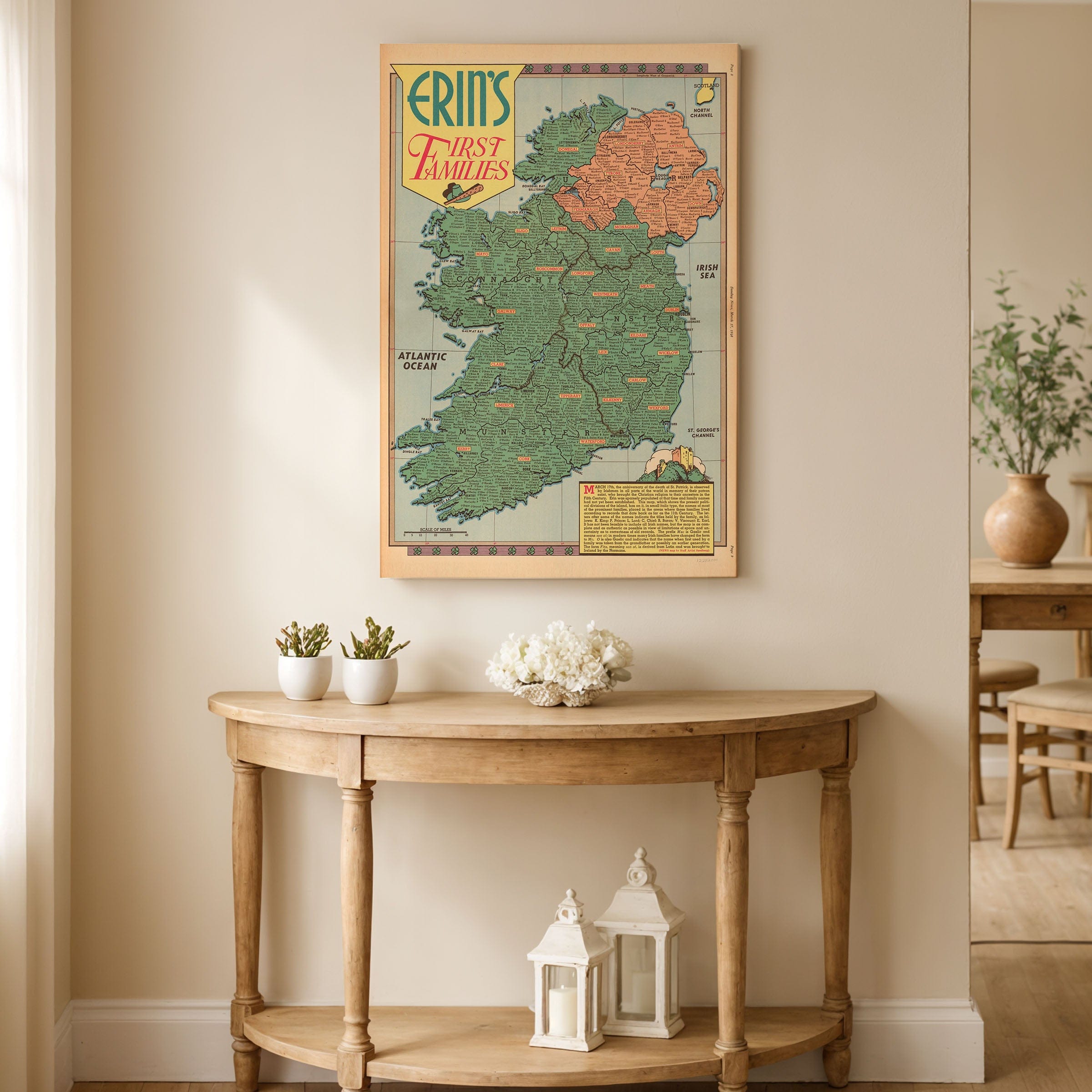
The Erin's First Families The Story of Ireland's Lineage Map meticulously labels each Irish county with the names of its historic families—O'Briens, O'Neills, O'Connors, MacCarthys, O'Donnells, and countless others whose surnames echo through generations. The distinctive green and orange color division highlights the political geography of the postwar era, distinguishing the newly independent Republic from Northern Ireland while celebrating a shared ancestry that long predates modern borders. This visual approach makes the complex tapestry of Irish genealogy accessible and engaging.
Across this Erin's First Families The Story of Ireland's Lineage Map, viewers discover how ancient kingdoms like Munster, Leinster, Connaught, and Ulster were once home to powerful dynasties whose traditions defined centuries of Irish life. Each family name represents not just a lineage but an entire region—echoes of poets, warriors, and chieftains whose descendants carried their heritage through conquest, famine, and diaspora. The stylized illustrations, decorative Celtic border, and vintage 1940s typography capture the postwar charm of mid-century cartography, blending historical reverence with artistic flair that makes this map both informative and beautiful.
The Erin's First Families The Story of Ireland's Lineage Map includes a thoughtful note marking March 17th—St. Patrick's Day—as a time of remembrance and pride, reminding viewers that Ireland's story is as spiritual as it is historical. The accompanying text celebrates how, by the 5th century, Ireland had been divided among these great families, whose descendants still bear their ancient surnames around the world. This connection between past and present makes the map deeply meaningful for the millions of people of Irish descent seeking to understand their ancestral homeland.
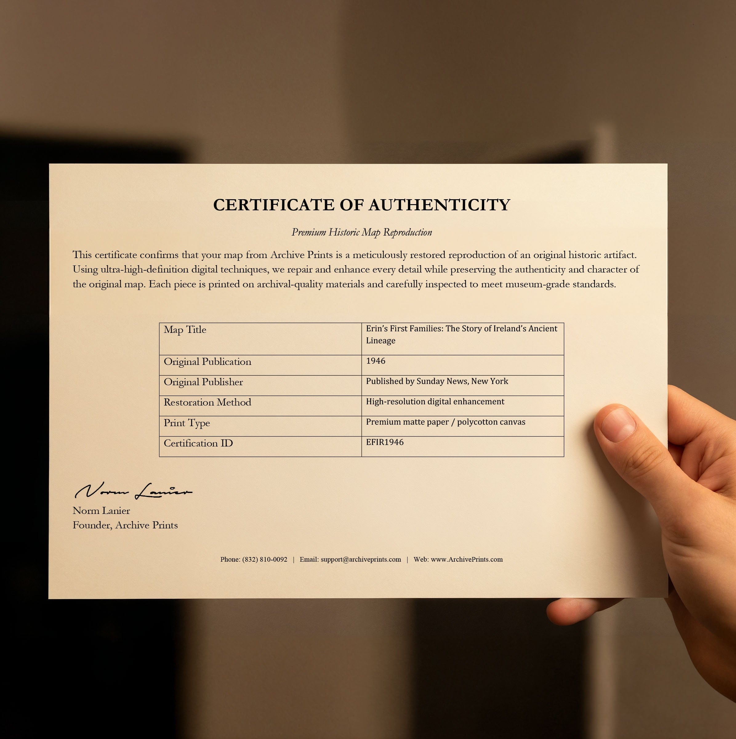
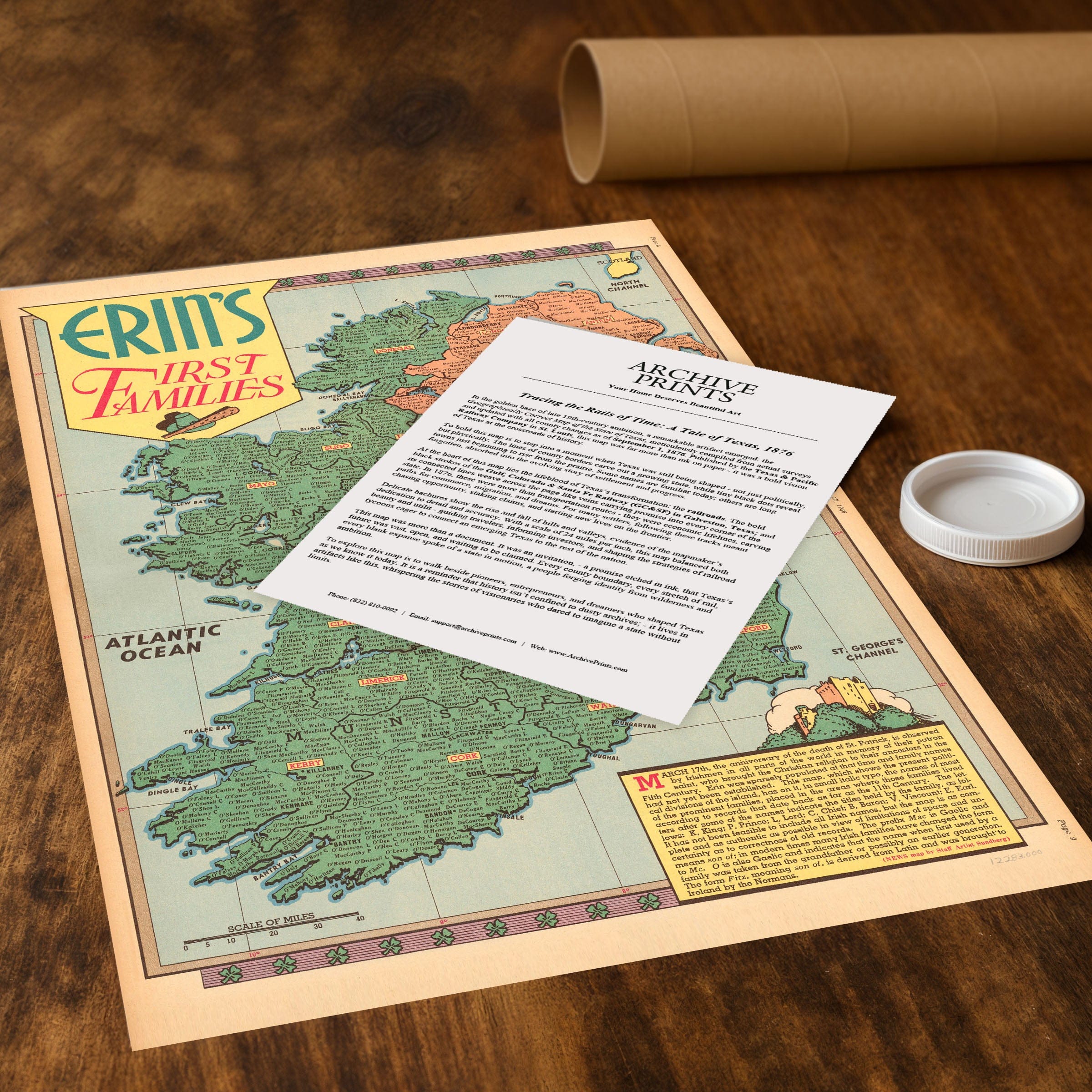
Perfect for Irish Americans, genealogy enthusiasts, and collectors of Celtic heritage, this Erin's First Families The Story of Ireland's Lineage Map reproduction includes a custom historical certificate. More than a map, it's a family tree of an entire nation—connecting generations of the Irish diaspora to the lands and lineages of their ancestors. Printed on heavyweight archival paper or hand-stretched polycotton canvas, every county label, family name, and decorative detail is restored in museum-grade clarity for generations of enjoyment. Paper prints ship rolled in heavy-duty tubes, while canvas editions arrive gallery-wrapped on solid pine stretcher bars with pre-installed hardware—ready to display the moment it arrives. Bring home a piece of Irish heritage and celebrate the ancient families that built a nation.
The Map Story
Each county of Ireland is meticulously labeled with the names of its historic Gaelic families—O'Briens, O'Neills, O'Connors, MacCarthys, O'Donnells, and countless others whose legacies shaped Irish identity. The green and orange color division highlights the political geography of the era, distinguishing the newly independent Republic from Northern Ireland, while celebrating a shared ancestry that long predates modern borders.
Across the map, the viewer discovers how ancient kingdoms like Munster, Leinster, Connaught, and Ulster were once home to dynasties whose power and traditions defined centuries of Irish life. Each name represents not just a lineage but a region—echoes of poets, warriors, and chieftains whose descendants carried their heritage through conquest, famine, and diaspora. The stylized illustrations, decorative border, and vintage typography capture the postwar charm of mid-20th-century cartography, blending historical reverence with artistic flair.
A note in the lower corner marks March 17th—St. Patrick's Day—as a time of remembrance and pride, reminding viewers that Ireland's story is as spiritual as it is historical. The text celebrates how, by the 5th century, Ireland had been divided among these great families, whose descendants still bear their ancient surnames around the world.
To modern eyes, Erin's First Families is more than a map—it's a family tree of a nation. It connects generations of the Irish diaspora to the lands and lineages of their ancestors, offering both a visual feast and a genealogical guide.
Materials
Choose options

Because every place has a story
Make History Personal
A vintage map is more than art.
It is a reminder of where life began.
Where memories were made.
Where hearts still live. Give the gift of place.
Beautifully preserved and made for the moments that matter.
Why Choose Us?
| Feature | Us | Competitor A | Competitor B |
|---|---|---|---|
| Hand Crafted | |||
| Museum Quality | |||
| 100 Year Guarantee | |||
| Restored by Hand | |||
| Certificate of Authenticity |

Art Prints
Archival quality colors. Best option if you'd like to frame it yourself

The Best Materials
We hand-stretched our canvas on solid American-grown pine stretcher bars. We use quality canvas and fade-resistant inks to create the lasting art. Canvases come with hardware already installed and ready to hang.
Need help?
Frequently Asked Questions
Order
All of our maps are meticulously restored reproductions of historic originals. Each piece is digitally repaired and color-corrected to bring out the finest details while preserving its authentic, vintage character.
Yes. All Archive Prints products are printed to order in the USA with archival materials.
We offer two premium formats:
- High-Quality Paper Posters – Printed on thick, archival-grade matte paper for rich, vibrant detail.
- Hand-Stretched Canvas Prints – Printed on premium polycotton canvas and mounted on 1.5" solid American pine stretcher bars for a gallery-quality finish.
We carefully digitally restore each map to enhance clarity and color while preserving its original look and historic charm. You’ll enjoy sharp details and a timeless vintage aesthetic that feels true to the original piece.
Yes, we do! We offer premium framing options to make your map ready to hang the moment it arrives. You can choose from Oak, Maple, Black, or Walnut frames directly on the product page. We also offer Stretched Canvas prints for a modern gallery look, as well as archival-quality Posters if you prefer to frame it yourself.
Yes! We offer free shipping on all products within the United States. Each map is carefully packaged to ensure it arrives in perfect condition.
If you’re not completely satisfied, you can return your order in new condition for a full refund. Return shipping costs are the responsibility of the customer.
Absolutely! Our maps make thoughtful, one-of-a-kind gifts for history lovers, map collectors, or anyone looking to add vintage character to their home or office. Choose between paper prints for framing or stretched canvas for a ready-to-hang presentation.
- Paper Posters → Shipped in durable, protective tubes to prevent creasing.
- Canvas Prints → Carefully wrapped, padded, and boxed to ensure safe delivery.
Our maps look stunning in a variety of settings, including:
- Living rooms and home offices
- Libraries and studies
- Corporate offices and conference rooms
- Restaurants, cafes, and boutique spaces