

Finger Lakes Region, New York Map 1934
Finger Lakes Region, New York Map 1934
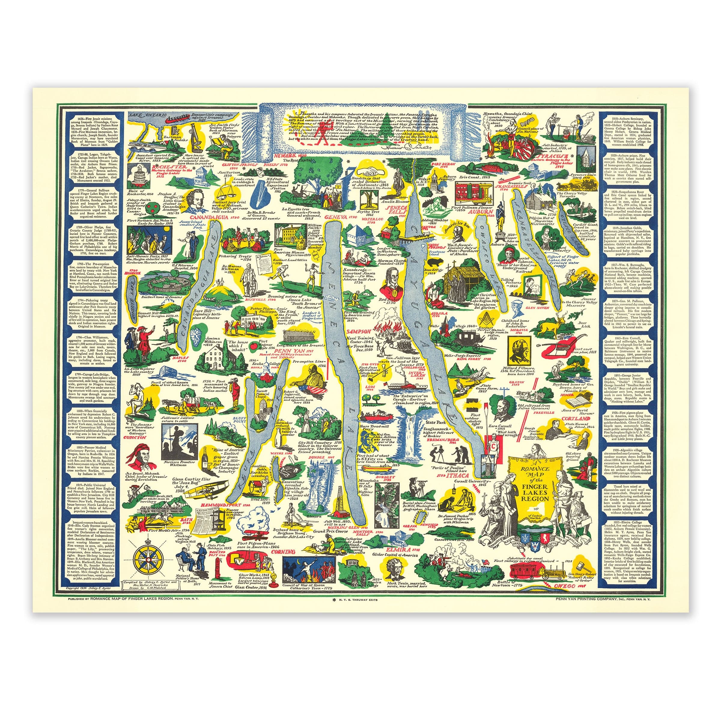
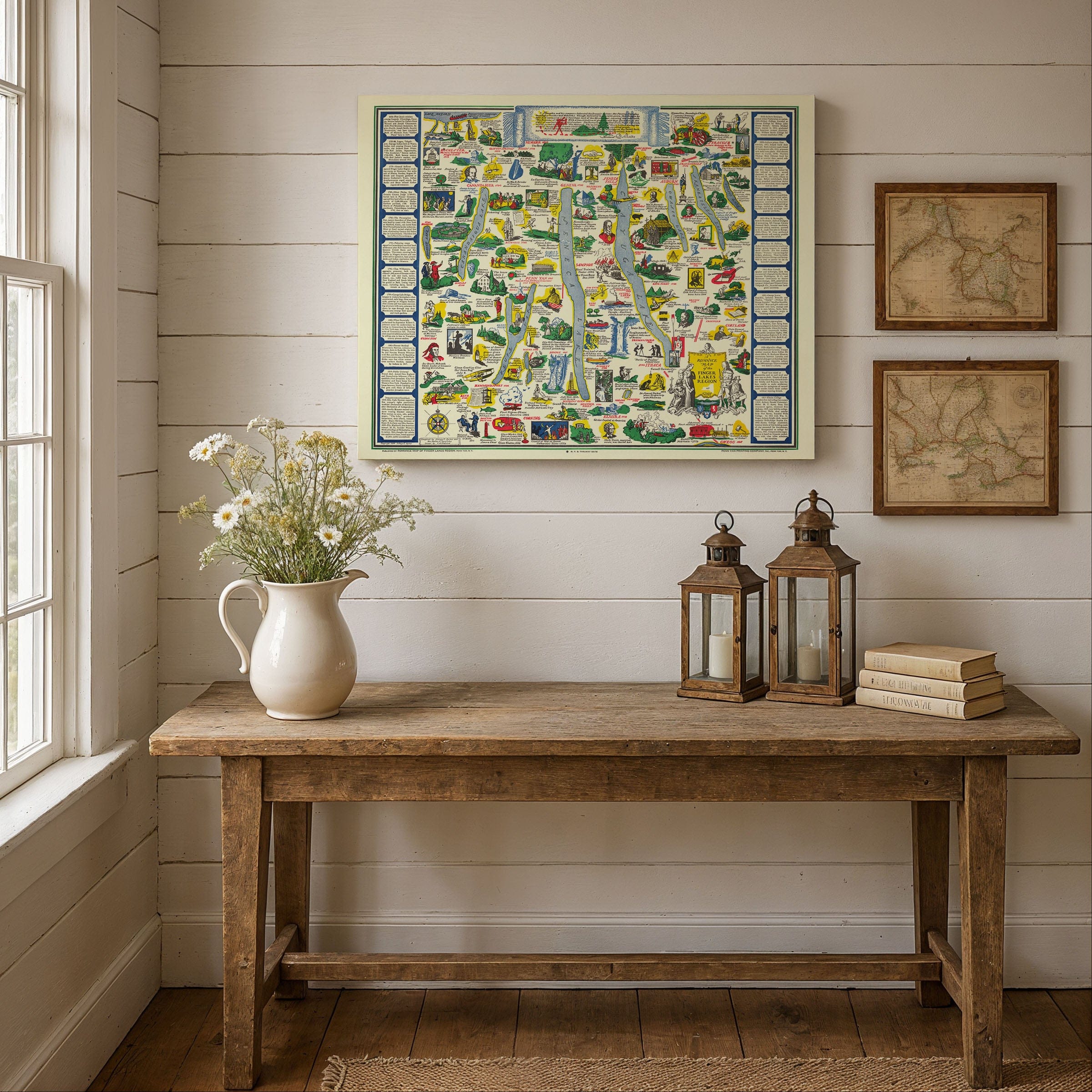
Step into the 1930s with this enchanting Finger Lakes Region, New York Map, a "Romance Map" published by the Penn Yan Printing Company that captures the region with playful illustration and historical storytelling. As Americans rediscovered regional heritage and scenic travel during this era, the Finger Lakes of New York emerged as a landscape rich with history, legend, and pastoral charm. This map turns deep glacial lakes and rolling hills into a vibrant tapestry of culture and memory, making it perfect for lovers of New York history and vintage travel art.
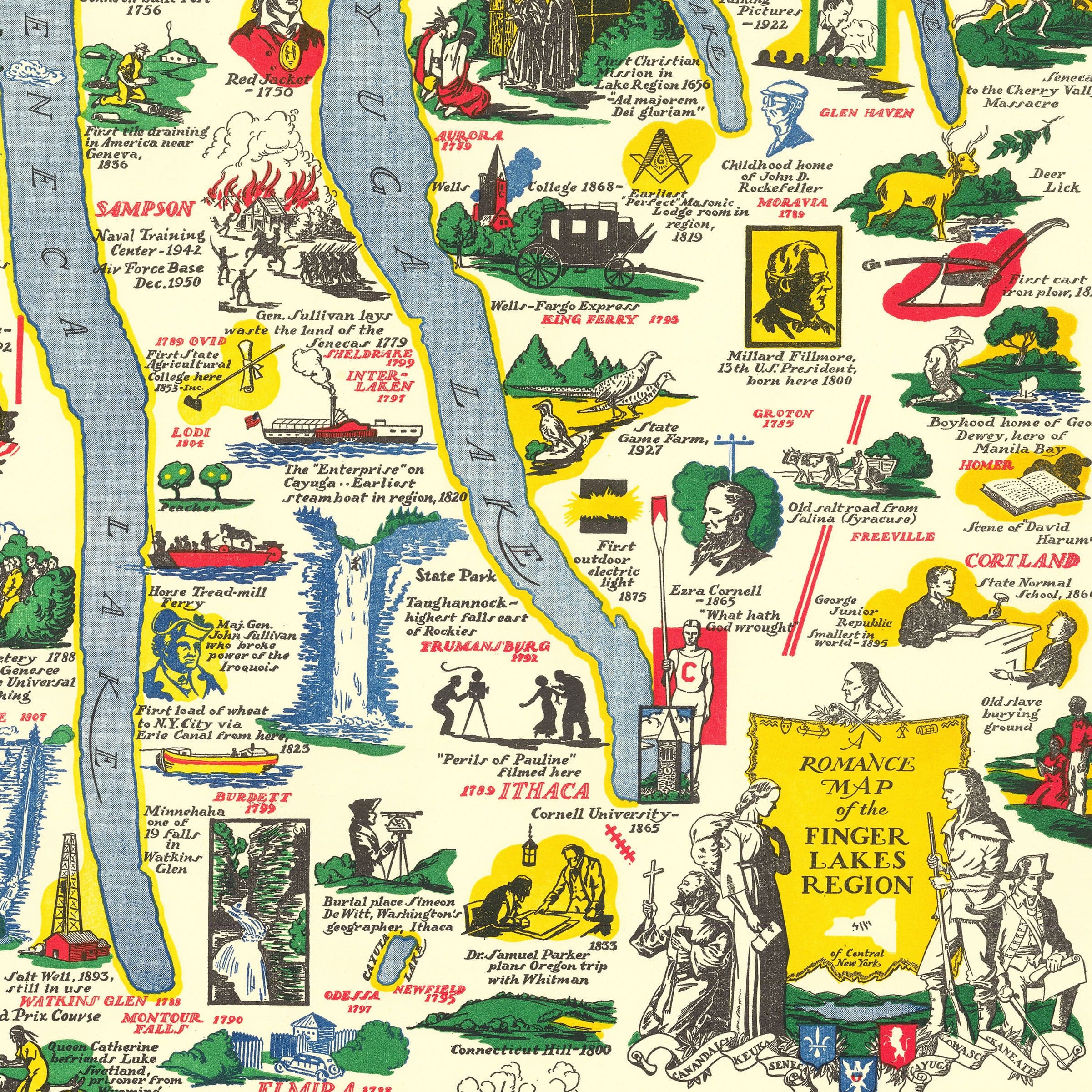
The Finger Lakes Region, New York Map showcases the Finger Lakes—long, narrow, glacial valleys filled with shimmering blue water—as the backbone of upstate New York. Around them, historic towns like Geneva, Canandaigua, Seneca Falls, Ithaca, Cortland, Watkins Glen, and Penn Yan appear as lively pictorial scenes, each labeled with narratives drawn from local lore. The lakes themselves—Seneca, Cayuga, Keuka, and Canandaigua—are dotted with pioneers, Iroquois figures, missionaries, explorers, and early settlers whose stories shaped this remarkable region.
Illustrations crowd the landscape of this Finger Lakes Region, New York Map, each one pointing to an event or personality that defined the area. Elizabeth Cady Stanton and the women of the Seneca Falls Convention stand beside historic canal routes; Glenn Curtiss, aviation pioneer of Hammondsport, appears near his early flying machines; and across the valleys, markers point to battles, treaties, and frontier settlements. The map brilliantly blends documented history with mythic storytelling, reflecting the region's unique mix of colonial memory and native heritage that makes the Finger Lakes so culturally significant.
Along the borders of this Finger Lakes Region, New York Map, columns of text recount key episodes in chronological detail—Revolutionary War movements, 19th-century reform efforts, religious revivals of the "Burned-over District," and the growth of colleges and cultural institutions. These narrative panels transform the map into both an educational guide and a celebration of local identity. Vineyards, waterfalls, orchards, and farms sweep across the illustrated canvas, anchoring the Finger Lakes as a landscape of natural abundance that continues to draw visitors today.
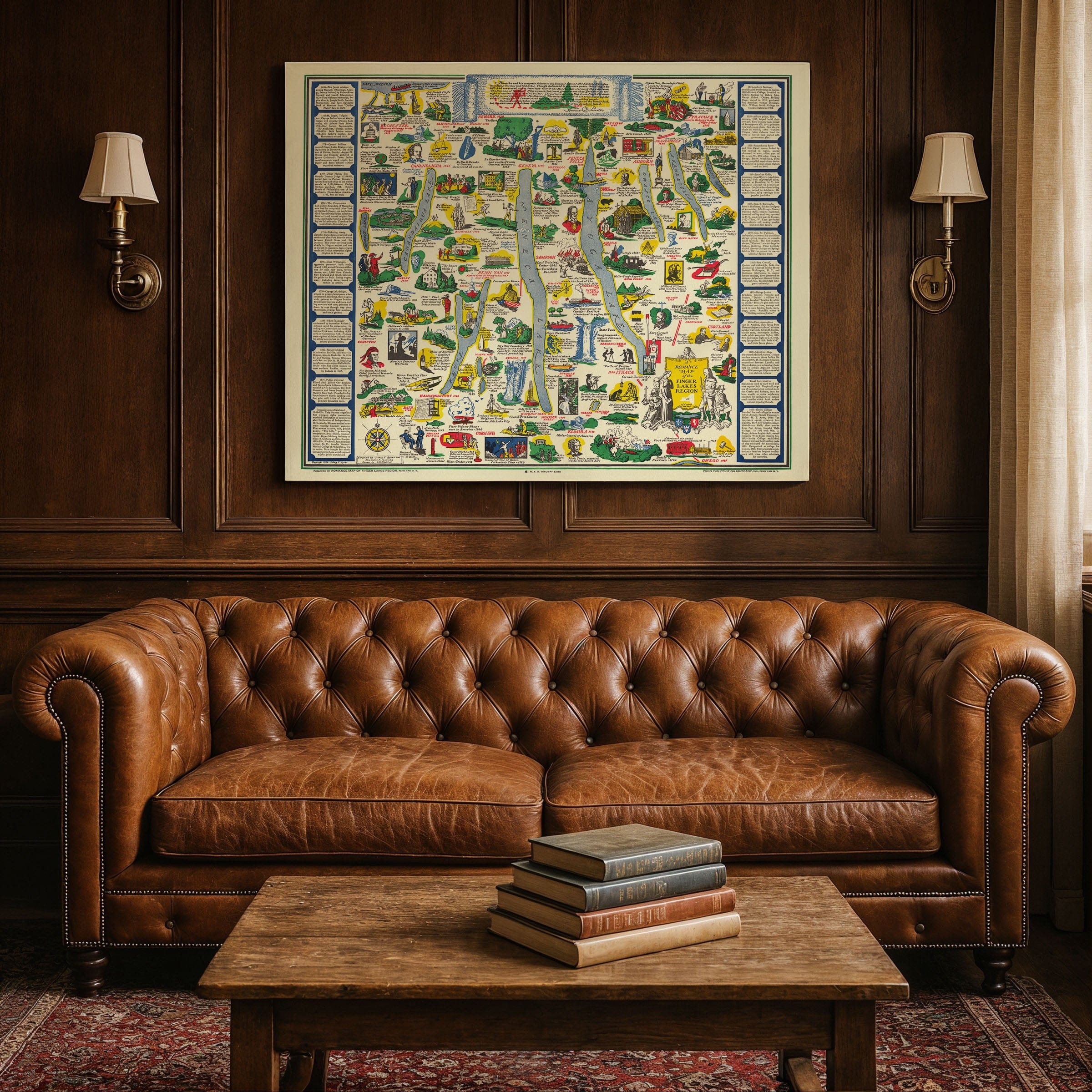
Perfect for Finger Lakes enthusiasts, New York collectors, and lovers of vintage travel art, this Finger Lakes Region, New York Map reproduction includes a custom historical certificate. Boats skim across the lakes, artists sketch beneath shaded trees, and scenes of rural life reinforce the region's reputation as one of New York's most picturesque corridors. Printed on heavyweight archival paper or hand-stretched polycotton canvas, every illustration, historical vignette, and scenic detail is restored in museum-grade clarity for generations of enjoyment. Paper prints ship rolled in heavy-duty tubes, while canvas editions arrive gallery-wrapped on solid pine stretcher bars with pre-installed hardware—ready to display the moment it arrives. Bring home a piece of Finger Lakes heritage and celebrate a region where scenery and story beautifully intertwine.
The Map Story
Stretching across the heart of upstate New York, the Finger Lakes—long, narrow, glacial valleys filled with shimmering blue water—serve as the map's backbone. Around them, towns like Geneva, Canandaigua, Seneca Falls, Ithaca, Cortland, Watkins Glen, and Penn Yan appear as lively pictorial scenes, each labeled with narratives drawn from local lore. The lakes themselves become pathways of history: Seneca, Cayuga, Keuka, and Canandaigua dotted with pioneers, Iroquois figures, missionaries, explorers, and early settlers whose stories shaped the region.
Illustrations crowd the landscape, each one pointing to an event or personality—statesmen and suffragists, military leaders, inventors, and visionary reformers. Elizabeth Cady Stanton and the women of the Seneca Falls Convention stand beside the flows of the historic canal routes; Glenn Curtiss, aviation pioneer of Hammondsport, appears near his early flying machines; and across the valleys, markers point to battles, treaties, and frontier settlements. The map blends documented history with mythic storytelling, reflecting the region's mix of colonial memory and native heritage.
Along the borders, columns of text recount key episodes in chronological detail—Revolutionary War movements, 19th-century reform efforts, religious revivals of the "Burned-over District," and the growth of colleges and cultural institutions. These narrative panels transform the map into both an educational guide and a celebration of local identity.
Vineyards, waterfalls, orchards, and farms sweep across the illustrated canvas, anchoring the Finger Lakes as a landscape of natural abundance. Boats skim across the lakes, artists sketch beneath shaded trees, and scenes of rural life reinforce the region's reputation as one of New York's most picturesque corridors. The overall effect is a joyful invitation to travel—by car, by water, or simply by imagination—through a region where scenery and story intertwine.
The Romance Map preserves the Finger Lakes at a moment when nostalgia, tourism, and regional pride converged. With its bold colors, lively sketches, and sweeping historical vignettes, it captures a place celebrated not only for its beauty but for the depth of its past.
Materials
Choose options

Because every place has a story
Make History Personal
A vintage map is more than art.
It is a reminder of where life began.
Where memories were made.
Where hearts still live. Give the gift of place.
Beautifully preserved and made for the moments that matter.
Why Choose Us?
| Feature | Us | Competitor A | Competitor B |
|---|---|---|---|
| Hand Crafted | |||
| Museum Quality | |||
| 100 Year Guarantee | |||
| Restored by Hand | |||
| Certificate of Authenticity |

Art Prints
Archival quality colors. Best option if you'd like to frame it yourself

The Best Materials
We hand-stretched our canvas on solid American-grown pine stretcher bars. We use quality canvas and fade-resistant inks to create the lasting art. Canvases come with hardware already installed and ready to hang.
Need help?
Frequently Asked Questions
Order
All of our maps are meticulously restored reproductions of historic originals. Each piece is digitally repaired and color-corrected to bring out the finest details while preserving its authentic, vintage character.
Yes. All Archive Prints products are printed to order in the USA with archival materials.
We offer two premium formats:
- High-Quality Paper Posters – Printed on thick, archival-grade matte paper for rich, vibrant detail.
- Hand-Stretched Canvas Prints – Printed on premium polycotton canvas and mounted on 1.5" solid American pine stretcher bars for a gallery-quality finish.
We carefully digitally restore each map to enhance clarity and color while preserving its original look and historic charm. You’ll enjoy sharp details and a timeless vintage aesthetic that feels true to the original piece.
Yes, we do! We offer premium framing options to make your map ready to hang the moment it arrives. You can choose from Oak, Maple, Black, or Walnut frames directly on the product page. We also offer Stretched Canvas prints for a modern gallery look, as well as archival-quality Posters if you prefer to frame it yourself.
Yes! We offer free shipping on all products within the United States. Each map is carefully packaged to ensure it arrives in perfect condition.
If you’re not completely satisfied, you can return your order in new condition for a full refund. Return shipping costs are the responsibility of the customer.
Absolutely! Our maps make thoughtful, one-of-a-kind gifts for history lovers, map collectors, or anyone looking to add vintage character to their home or office. Choose between paper prints for framing or stretched canvas for a ready-to-hang presentation.
- Paper Posters → Shipped in durable, protective tubes to prevent creasing.
- Canvas Prints → Carefully wrapped, padded, and boxed to ensure safe delivery.
Our maps look stunning in a variety of settings, including:
- Living rooms and home offices
- Libraries and studies
- Corporate offices and conference rooms
- Restaurants, cafes, and boutique spaces