Fort Worth 1886 Décor - Queen of the Prairies Home Accent
Discover the City That Rose From the Prairie
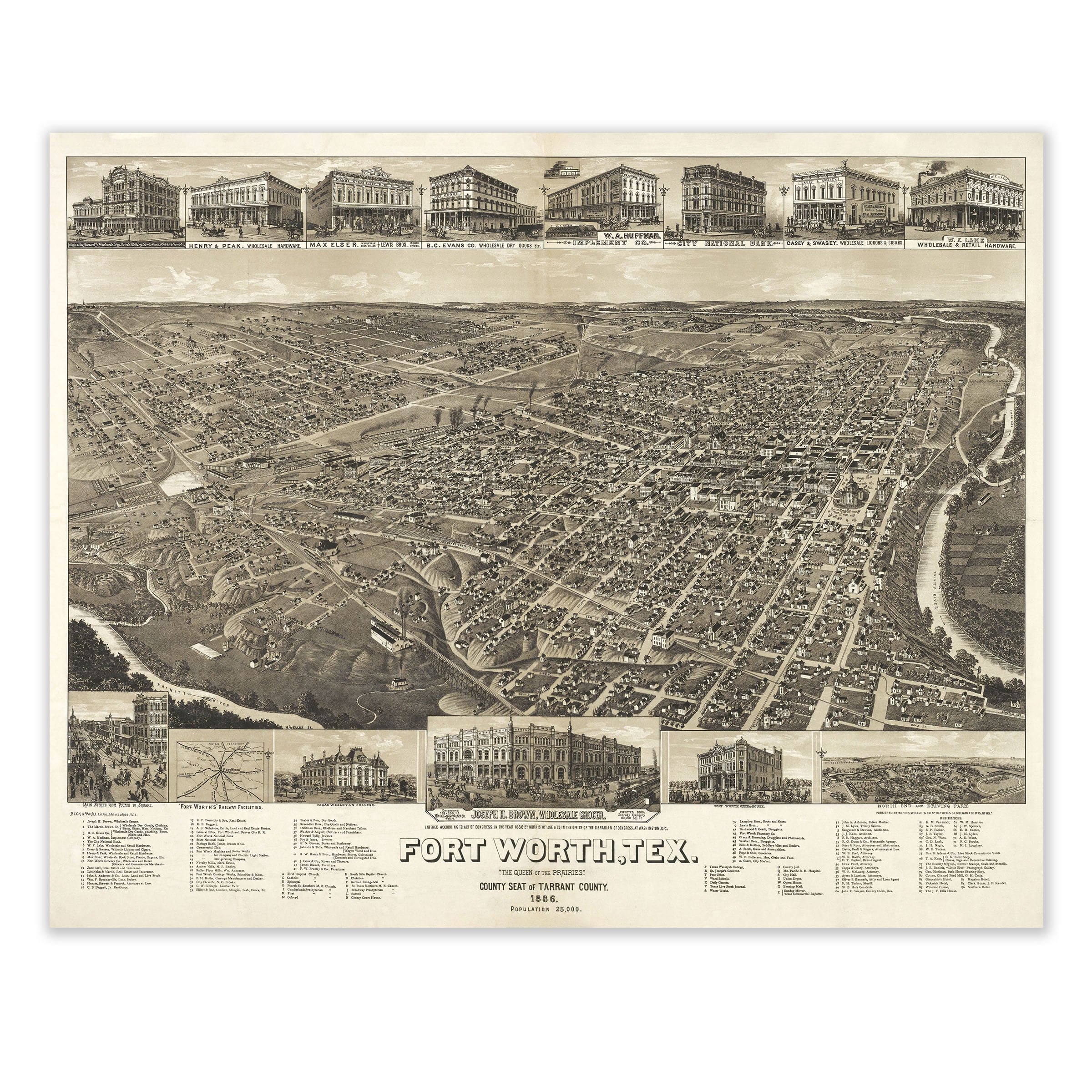
Travel back to 1886, when Fort Worth stood at the threshold of greatness—a frontier town transforming into a modern city. This meticulously restored panoramic lithograph, originally created by Henry Wellge and published by Norris, Wellge & Co. of Milwaukee, captures a moment when ambition, industry, and civic pride converged to shape the future of North Texas.
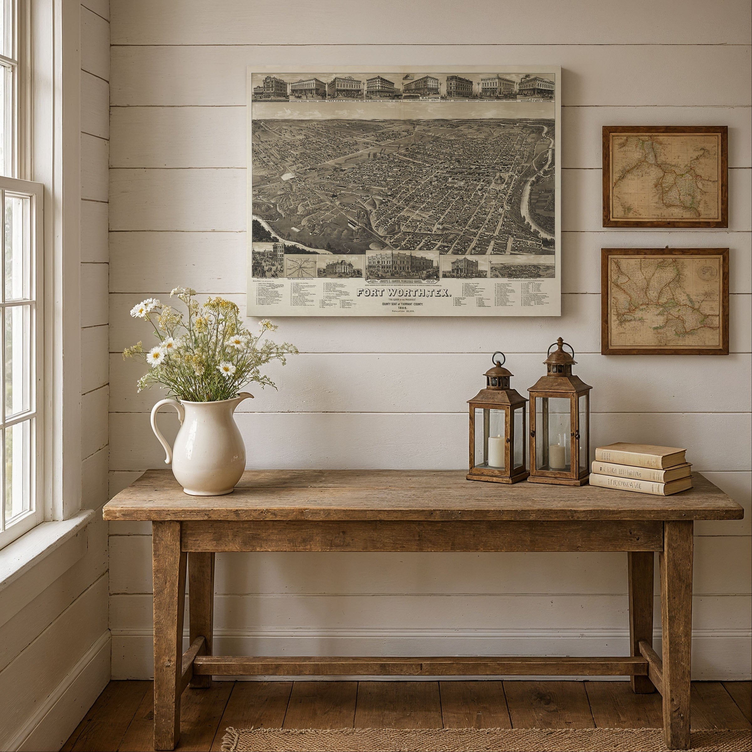
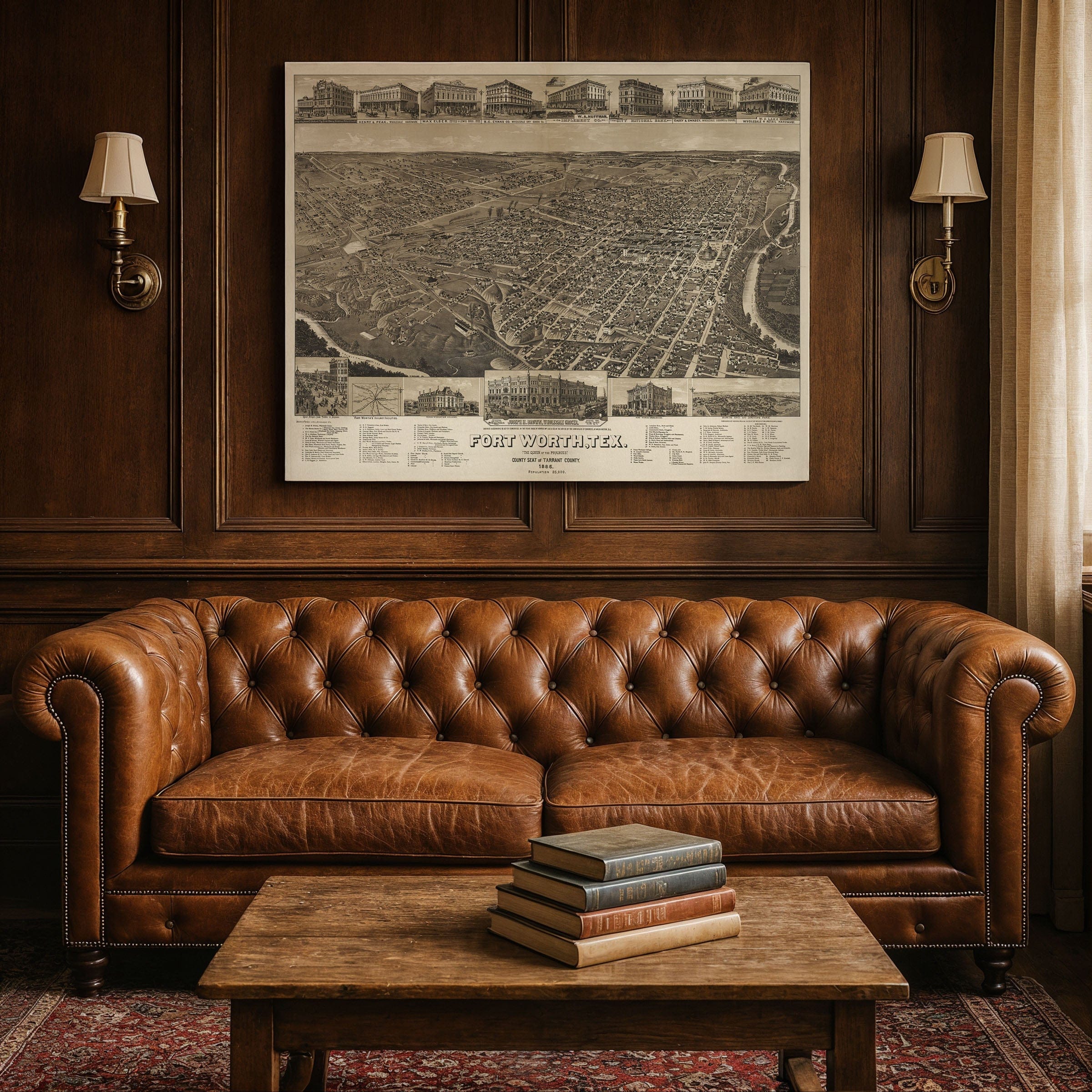
Titled Fort Worth, Tex., "The Queen of the Prairies," County Seat of Tarrant County, this bird's-eye view reveals a city alive with motion. Train depots buzz with activity, wagon roads wind through growing neighborhoods, and rows of storefronts spread outward from a thriving downtown grid. Every building proclaims Fort Worth's new identity as a place of permanence and prosperity, where the raw energy of the frontier was giving way to the ordered ambition of a modern metropolis.
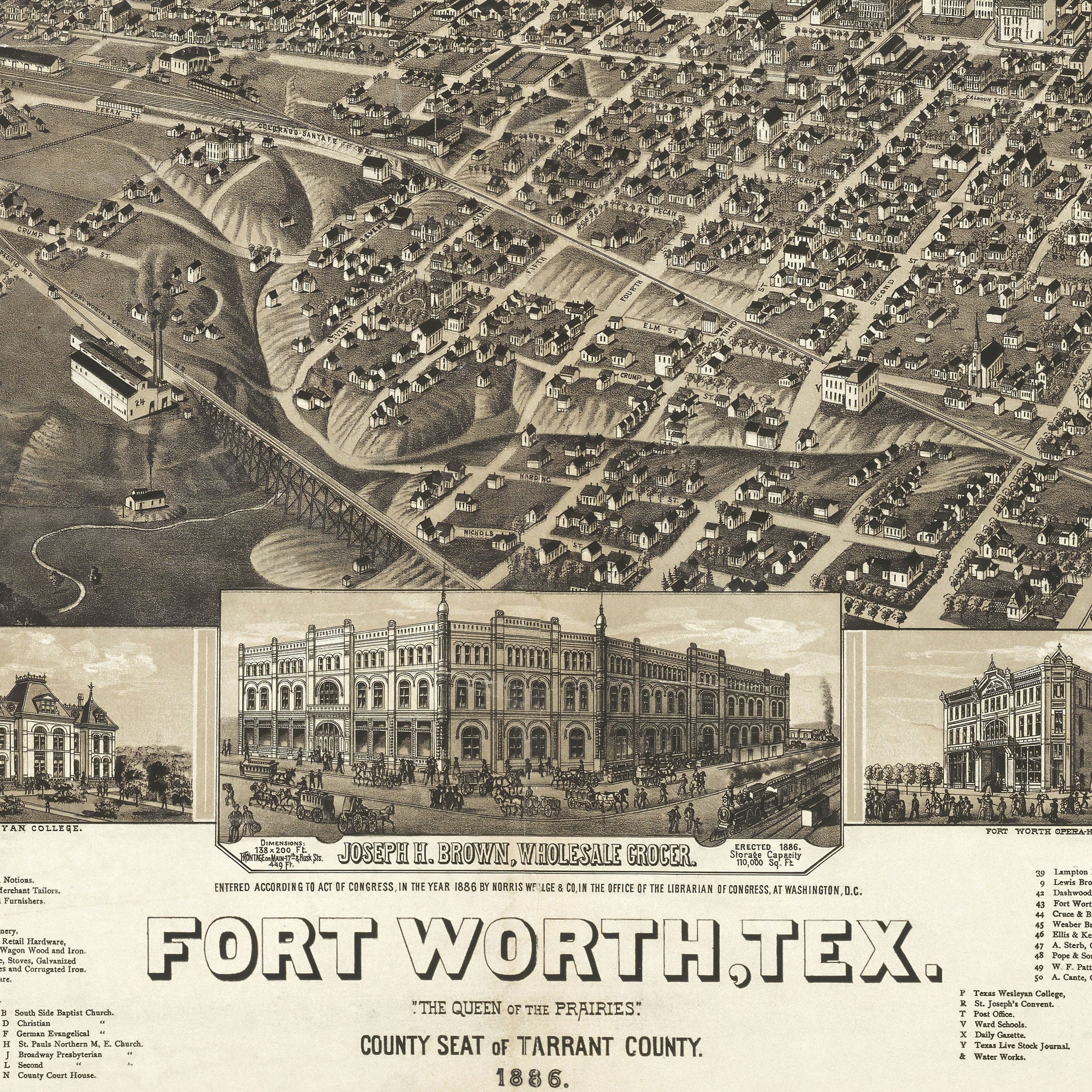
The railroads had changed everything. By 1886, lines from Houston, Galveston, and Dallas converged in Fort Worth, linking it to the Gulf and the Great Plains. Livestock pens and freight yards filled the northern edge of the city—the foundation of what would become the legendary Stockyards District. These iron rails transformed Fort Worth into a magnet for cattlemen and entrepreneurs, turning its prairie landscape into one of the busiest shipping points in Texas.
Civic pride radiates from every corner of this composition. The courthouse, schools, and churches stand prominently as symbols of stability and self-confidence. Streets are clean and orderly, reflecting a disciplined vision for growth. Beyond the town's edges, open farmland and winding creeks reveal how closely the city still bordered wilderness. The title—"Queen of the Prairies"—was both boast and prophecy, expressing an unshakeable faith that Fort Worth would soon reign as the economic heart of North Texas.
This was a pivotal era for Fort Worth. Once a modest army outpost overlooking the Trinity River, it had become a vital commercial hub for ranchers, traders, and settlers pushing west. Yet beneath the optimism lay tension—boom years fueled by speculation and fragile markets, where a bad season or a stalled rail line could topple fortunes overnight. But the people who built Fort Worth believed in resilience, and they gambled everything on the city's promise.
Today, this 1886 view endures as a portrait of Fort Worth at the moment it came of age—a place straddling the line between frontier and modernity, where the prairie met the railroad and ambition took root. Each reproduction includes a custom historical letter detailing the story behind the map, making it perfect for Texas history enthusiasts, collectors of Western Americana, and anyone who cherishes Fort Worth's heritage.
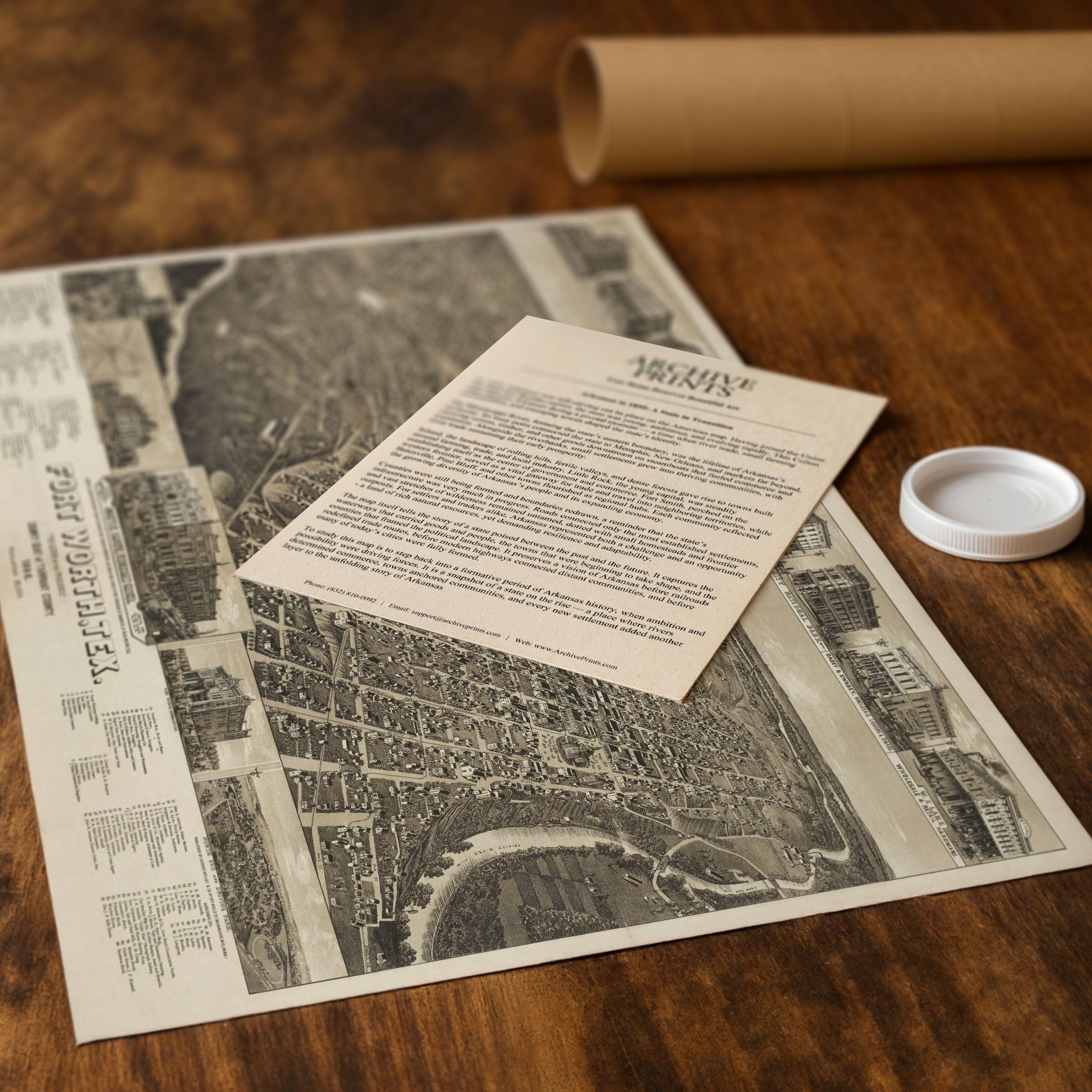
Printed on heavyweight archival paper or hand-stretched polycotton canvas, every building, street, and landmark is restored in museum-grade clarity for generations of enjoyment. Paper prints ship rolled in heavy-duty tubes, while canvas editions arrive gallery-wrapped on solid pine stretcher bars with pre-installed hardware—ready to display the moment it arrives.
Bring home a piece of Fort Worth's pioneering legacy and celebrate the bold vision that transformed a frontier outpost into the Queen of the Prairies.
The Map Story
In 1886, Fort Worth stood at the threshold of greatness - a frontier town transforming into a modern city. This panoramic lithograph, titled Fort Worth, Tex., “The Queen of the Prairies,” County Seat of Tarrant County, 1886, was created by Henry Wellge and published by Norris, Wellge & Co. of Milwaukee. More than just a map, it is a vision of progress, optimism, and ambition rendered in meticulous detail.
At the time, Fort Worth was rising from the shadow of its military past. Once a modest army outpost overlooking the Trinity River, it had become a vital commercial hub for ranchers, traders, and settlers pushing west. The map’s sweeping bird’s-eye view captures a city alive with motion—train depots, wagon roads, mills, and rows of storefronts spreading outward from a growing downtown grid. Every building seems to proclaim the city’s new identity as a place of industry and permanence.
The arrival of the railroads had changed everything. By 1886, lines from Houston, Galveston, and Dallas converged here, linking Fort Worth to the Gulf and the Great Plains. Livestock pens, freight yards, and warehouses filled the northern edge of the city, forming the foundation of what would later become the famous Stockyards District. Railroads made Fort Worth a magnet for cattlemen and entrepreneurs, turning its prairie landscape into one of the busiest shipping points in Texas.
Civic pride is visible throughout the composition. The courthouse, schools, and churches stand prominently, symbols of stability and self-confidence. Streets are clean and orderly, hinting at a disciplined vision for growth. Beyond the town’s edges, open farmland and winding creeks reveal how closely the city still bordered wilderness. The title - “Queen of the Prairies” - was both boast and prophecy, expressing a faith that Fort Worth would soon reign as the economic heart of North Texas.
Yet beneath the optimism lay tension. The boom years were fueled by speculation and fragile markets. A bad season, a stalled rail line, or a drop in cattle prices could topple fortunes overnight. But the people who built Fort Worth believed in resilience. They carved their city from raw land and gambled everything on its promise.
Today, this 1886 view endures as a portrait of Fort Worth at the moment it came of age - a place straddling the line between frontier and modernity, where the prairie met the railroad and ambition took root.
Materials
Choose options

Because every place has a story
Make History Personal
A vintage map is more than art.
It is a reminder of where life began.
Where memories were made.
Where hearts still live. Give the gift of place.
Beautifully preserved and made for the moments that matter.
Why Choose Us?
| Feature | Us | Competitor A | Competitor B |
|---|---|---|---|
| Hand Crafted | |||
| Museum Quality | |||
| 100 Year Guarantee | |||
| Restored by Hand | |||
| Certificate of Authenticity |

Art Prints
Archival quality colors. Best option if you'd like to frame it yourself

The Best Materials
We hand-stretched our canvas on solid American-grown pine stretcher bars. We use quality canvas and fade-resistant inks to create the lasting art. Canvases come with hardware already installed and ready to hang.
Need help?
Frequently Asked Questions
Order
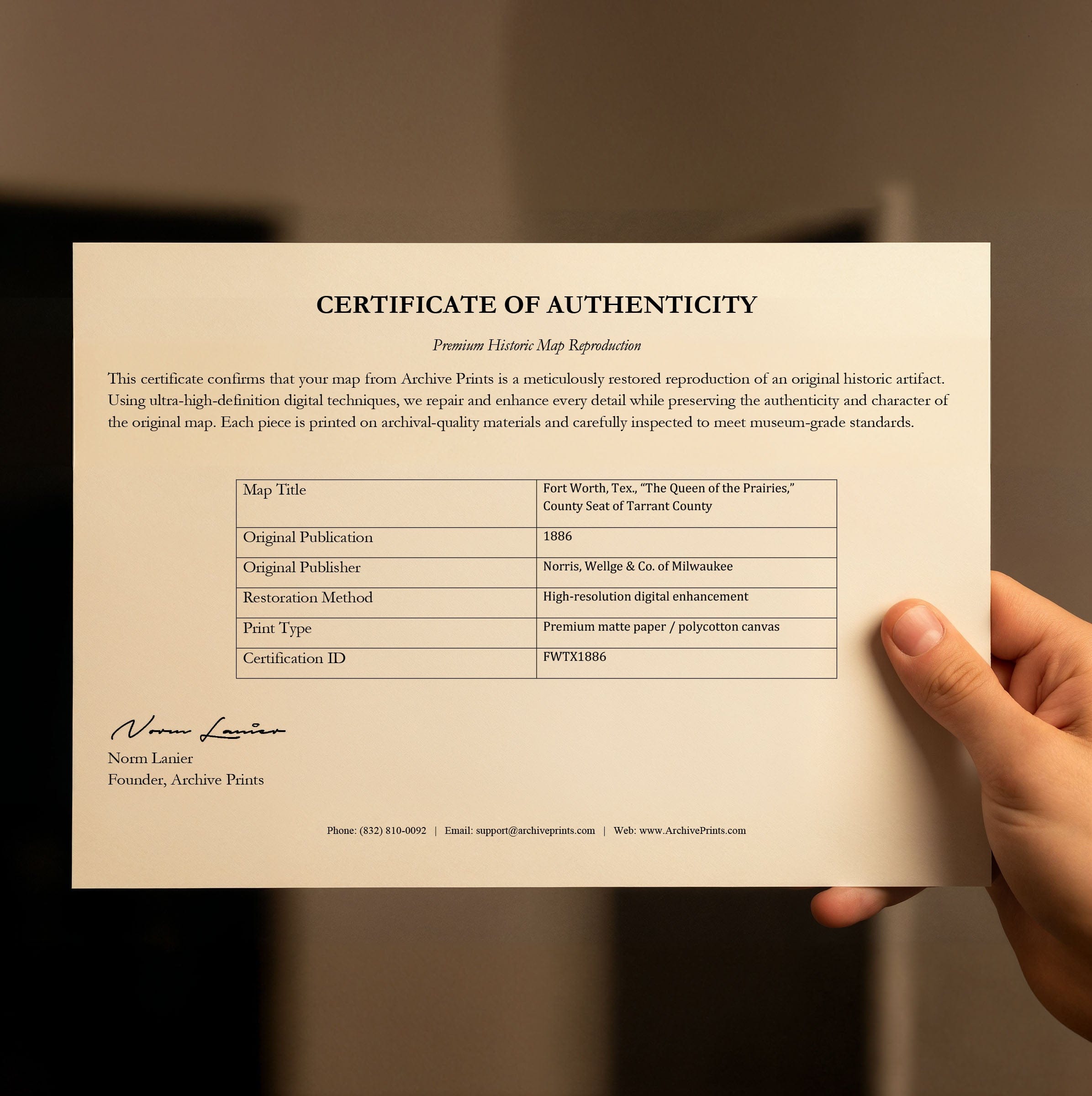
All of our maps are meticulously restored reproductions of historic originals. Each piece is digitally repaired and color-corrected to bring out the finest details while preserving its authentic, vintage character.
Yes. All Archive Prints products are printed to order in the USA with archival materials.
We offer two premium formats:
- High-Quality Paper Posters – Printed on thick, archival-grade matte paper for rich, vibrant detail.
- Hand-Stretched Canvas Prints – Printed on premium polycotton canvas and mounted on 1.5" solid American pine stretcher bars for a gallery-quality finish.
We carefully digitally restore each map to enhance clarity and color while preserving its original look and historic charm. You’ll enjoy sharp details and a timeless vintage aesthetic that feels true to the original piece.
Yes, we do! We offer premium framing options to make your map ready to hang the moment it arrives. You can choose from Oak, Maple, Black, or Walnut frames directly on the product page. We also offer Stretched Canvas prints for a modern gallery look, as well as archival-quality Posters if you prefer to frame it yourself.
Yes! We offer free shipping on all products within the United States. Each map is carefully packaged to ensure it arrives in perfect condition.
If you’re not completely satisfied, you can return your order in new condition for a full refund. Return shipping costs are the responsibility of the customer.
Absolutely! Our maps make thoughtful, one-of-a-kind gifts for history lovers, map collectors, or anyone looking to add vintage character to their home or office. Choose between paper prints for framing or stretched canvas for a ready-to-hang presentation.
- Paper Posters → Shipped in durable, protective tubes to prevent creasing.
- Canvas Prints → Carefully wrapped, padded, and boxed to ensure safe delivery.
Our maps look stunning in a variety of settings, including:
- Living rooms and home offices
- Libraries and studies
- Corporate offices and conference rooms
- Restaurants, cafes, and boutique spaces