Fulton County, Georgia Map 1872
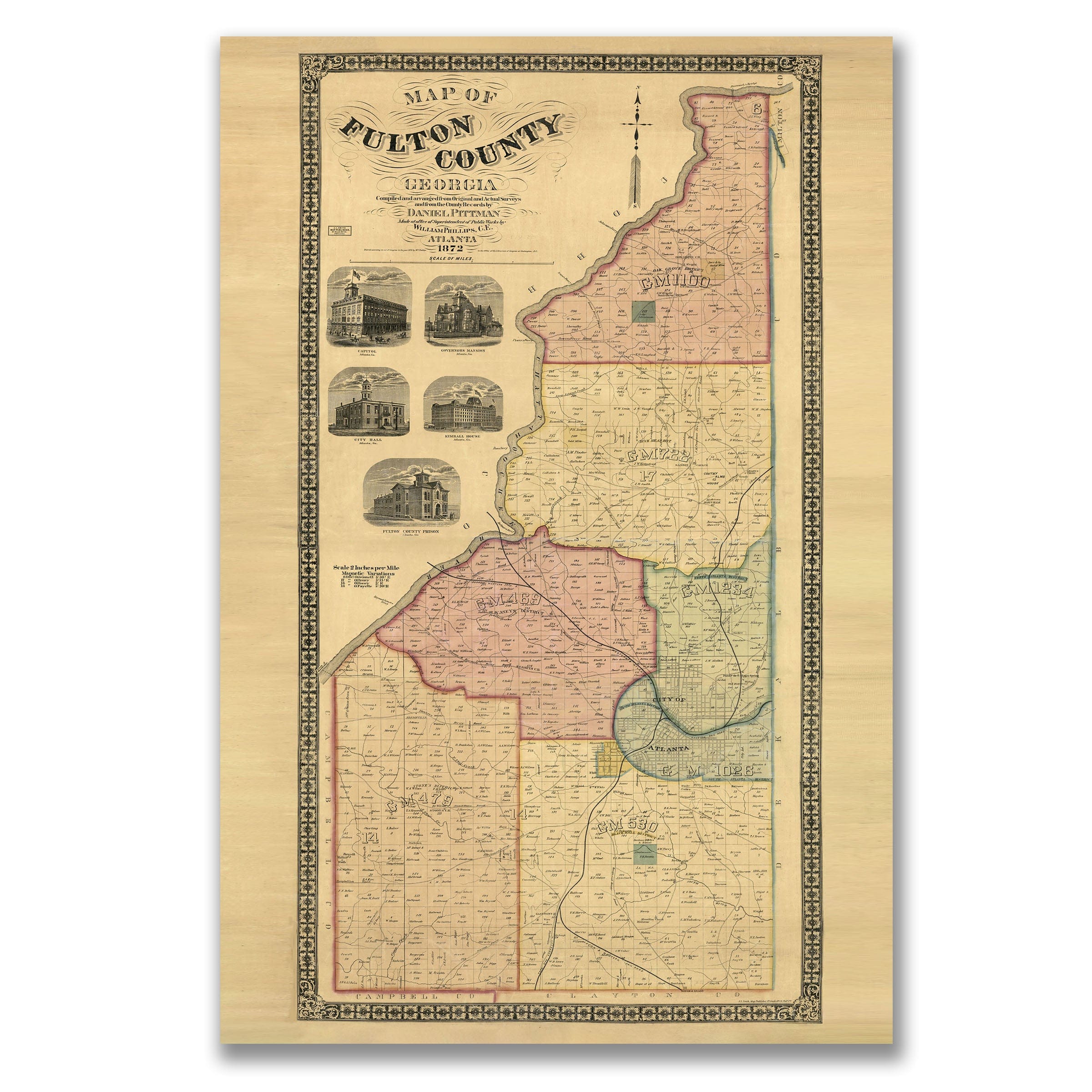
Discover the historic Fulton County, Georgia Map from 1872 that captures a county rebuilding with energy and ambition, emerging from the Civil War determined to reclaim its place as a central force in Georgia's economic and civic life. This vintage map style richly detailed map, prepared by surveyor Daniel Pittman and published by civil engineer William Phillips, showcases Fulton County in transition, striving to balance its rural heritage with the momentum of a rapidly expanding Atlanta during the early years of Reconstruction. The Fulton County, Georgia Map unfolds broad districts in intricate detail, featuring scattered homesteads, mills, orchards, and crossroads communities that reflect a countryside still deeply connected to farming and family landholdings, with winding roads linking small settlements while churches and schools mark the essential institutions that guided daily life in this old map aesthetic. At the center of the county, Atlanta rises as a compact but determined urban hub, barely seven years after its wartime destruction, already redefining itself through commerce and transportation with railroads—Western & Atlantic, Georgia Railroad, and Macon & Western—intersecting in a dense cluster, forming the lifelines that carried passengers, cotton, timber, and manufactured goods across the region. This vintage map features carefully drawn rail networks that hint at the city's growing influence and foreshadow its emergence as Georgia's capital just a short time later. The engravings along the left side add both texture and pride, showcasing City Hall, the Kimball House hotel, federal buildings, and the Fulton County Prison that illustrate the civic identity Atlanta sought to rebuild, representing stability, progress, and the restoration of public life after years of upheaval. Beyond the city, quiet districts such as G.M. 488, 479, 530, and 1026 capture the broader county's character in this old map, with creeks, roads, and property lines tracing the early settlement patterns that shaped the region, many of these areas still largely rural in 1872 that would one day become integral parts of metropolitan Atlanta as the city expanded outward. This vintage map preserves a vivid snapshot of Fulton County at a defining moment—rooted in fields and farms, yet propelled by the energy of a city rising from adversity, inviting viewers to step into a county on the threshold of transformation, its future already visible in the rail lines, communities, and ambitions set across the page. Each reproduction includes a custom historical letter detailing the story behind the map, making it perfect for Georgia collectors, Atlanta history enthusiasts, and Civil War Reconstruction scholars. Printed on heavyweight archival paper or hand-stretched polycotton canvas, every railroad, homestead, and district detail is rendered in museum-grade clarity for generations of enjoyment. Paper prints ship rolled in heavy-duty tubes, while canvas editions arrive gallery-wrapped on solid pine stretcher bars with pre-installed hardware—ready to display the moment it arrives. Bring home the spirit of 1872 Fulton County and celebrate a region rebuilding with determination and vision for the future.
The Map Story
Materials
Choose options

Because every place has a story
Make History Personal
A vintage map is more than art.
It is a reminder of where life began.
Where memories were made.
Where hearts still live. Give the gift of place.
Beautifully preserved and made for the moments that matter.
Why Choose Us?
| Feature | Us | Competitor A | Competitor B |
|---|---|---|---|
| Hand Crafted | |||
| Museum Quality | |||
| 100 Year Guarantee | |||
| Restored by Hand | |||
| Certificate of Authenticity |

Art Prints
Archival quality colors. Best option if you'd like to frame it yourself

The Best Materials
We hand-stretched our canvas on solid American-grown pine stretcher bars. We use quality canvas and fade-resistant inks to create the lasting art. Canvases come with hardware already installed and ready to hang.
Need help?
Frequently Asked Questions
Order
All of our maps are meticulously restored reproductions of historic originals. Each piece is digitally repaired and color-corrected to bring out the finest details while preserving its authentic, vintage character.
Yes. All Archive Prints products are printed to order in the USA with archival materials.
We offer two premium formats:
- High-Quality Paper Posters – Printed on thick, archival-grade matte paper for rich, vibrant detail.
- Hand-Stretched Canvas Prints – Printed on premium polycotton canvas and mounted on 1.5" solid American pine stretcher bars for a gallery-quality finish.
We carefully digitally restore each map to enhance clarity and color while preserving its original look and historic charm. You’ll enjoy sharp details and a timeless vintage aesthetic that feels true to the original piece.
Yes, we do! We offer premium framing options to make your map ready to hang the moment it arrives. You can choose from Oak, Maple, Black, or Walnut frames directly on the product page. We also offer Stretched Canvas prints for a modern gallery look, as well as archival-quality Posters if you prefer to frame it yourself.
Yes! We offer free shipping on all products within the United States. Each map is carefully packaged to ensure it arrives in perfect condition.
If you’re not completely satisfied, you can return your order in new condition for a full refund. Return shipping costs are the responsibility of the customer.
Absolutely! Our maps make thoughtful, one-of-a-kind gifts for history lovers, map collectors, or anyone looking to add vintage character to their home or office. Choose between paper prints for framing or stretched canvas for a ready-to-hang presentation.
- Paper Posters → Shipped in durable, protective tubes to prevent creasing.
- Canvas Prints → Carefully wrapped, padded, and boxed to ensure safe delivery.
Our maps look stunning in a variety of settings, including:
- Living rooms and home offices
- Libraries and studies
- Corporate offices and conference rooms
- Restaurants, cafes, and boutique spaces