


Galveston Vintage Map - 1885 Koch Historical Bird's-Eye City Map
Galveston 1885: The Story Behind the Map
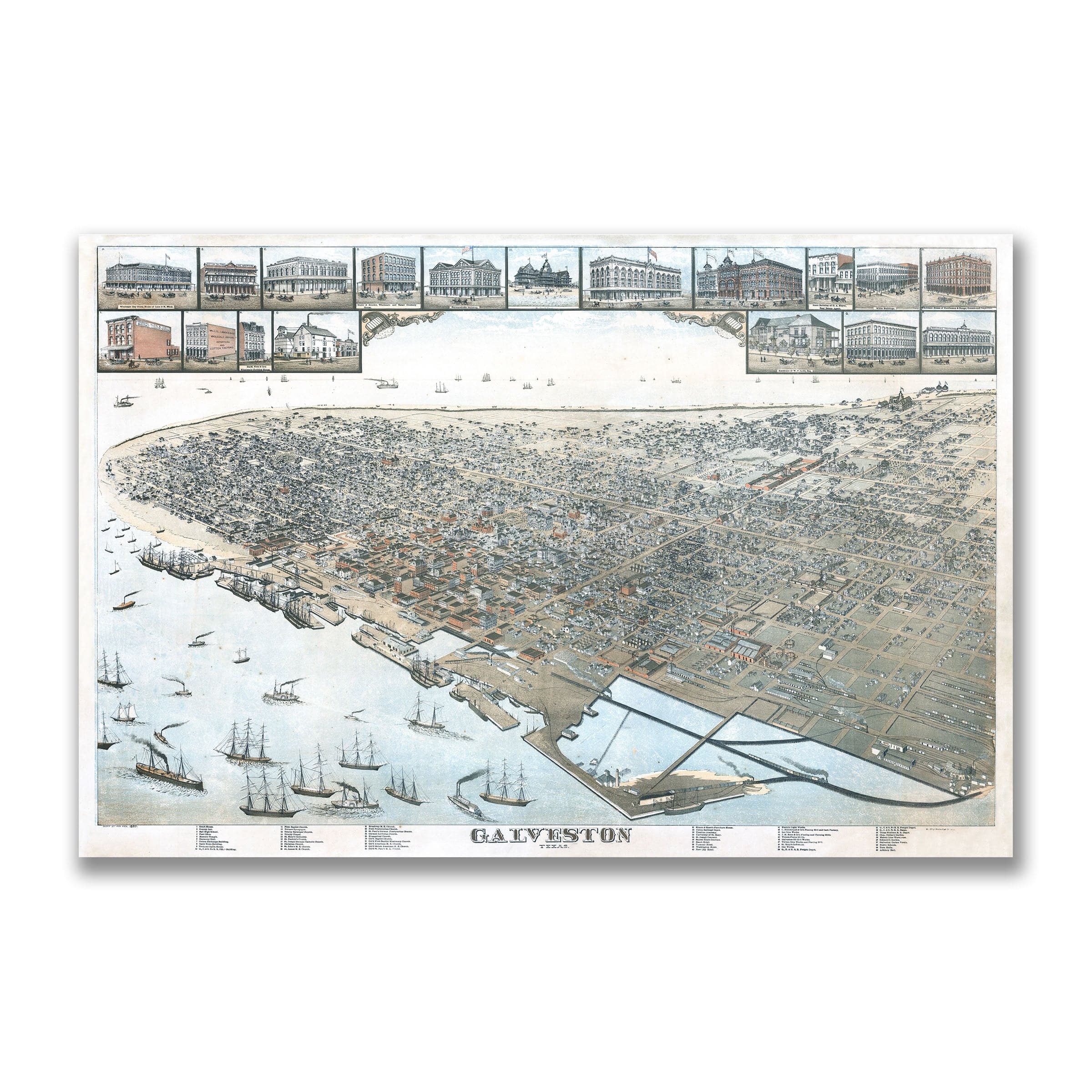
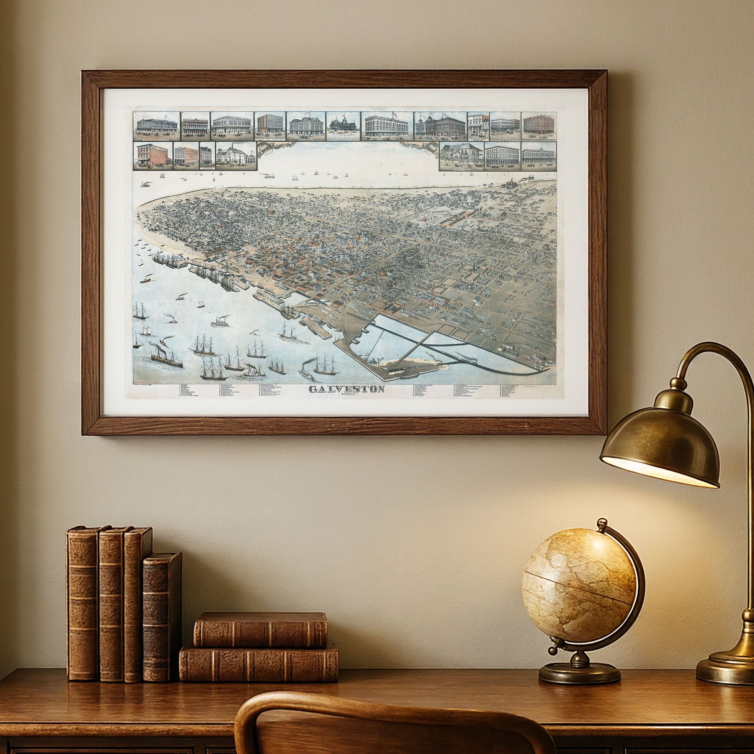
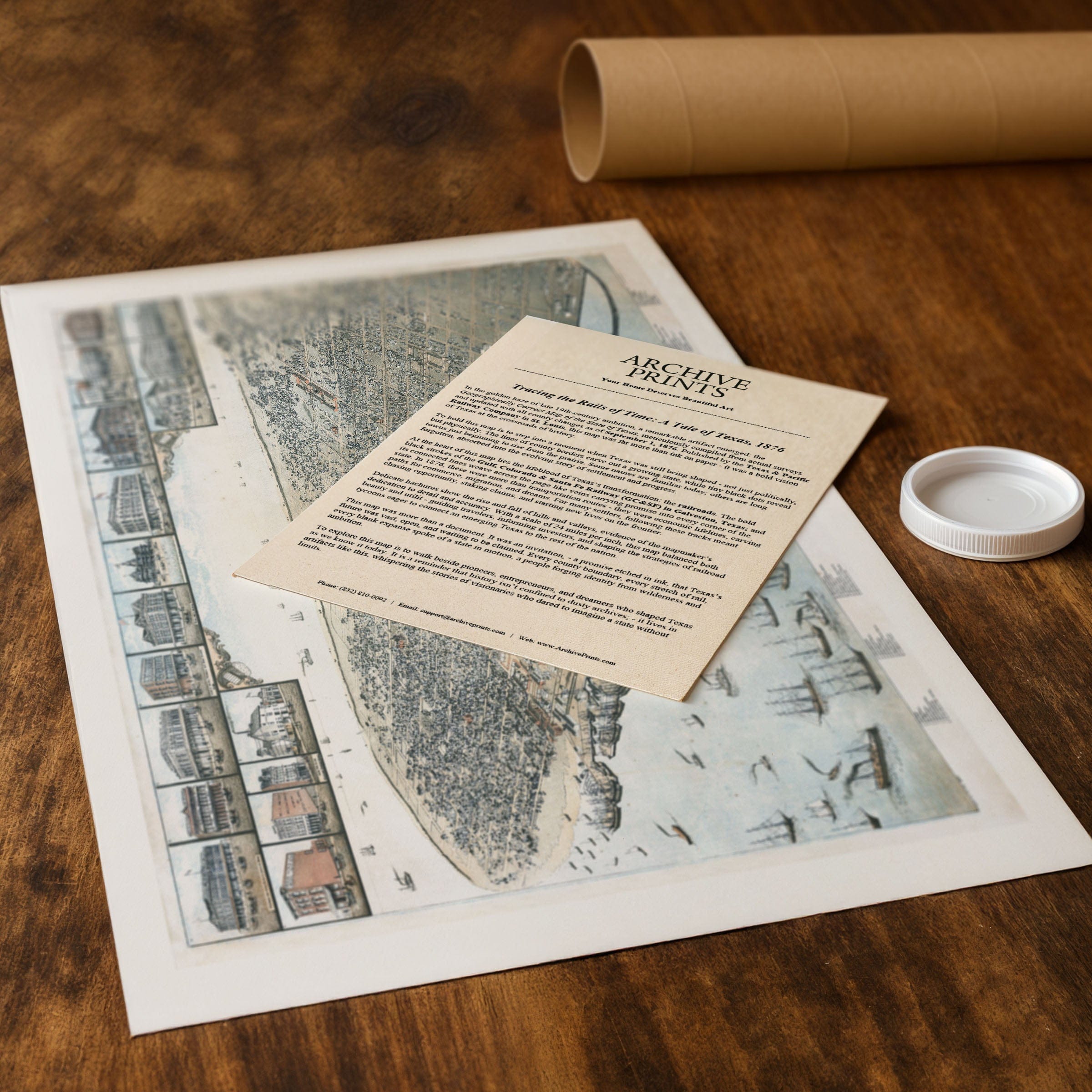
Explore the golden era of Gulf-Coast trade and urban ambition with this exquisitely restored 1885 Bird’s-Eye View of Galveston, Texas, drawn by Augustus Koch and published by Victor Phillips Stationery in Galveston. This panoramic lithograph captures the city at its peak—when steamships, immigration, cotton flow, and rail lines converged in a dazzling hub on the Gulf of Mexico. From this elevated perspective, the port dominates the scene: masts and funnels crowd the harbor, piers stretch outward into Galveston Bay, and the wharfside warehouses hum with commerce. In the backdrop, the neat grid of streets rises from the shoreline, filled with hotels, churches, cigar factories, and elegant homes—each a sign that Galveston was not just a coastal town, but a major city of the South. The map illustrates more than geography: it maps aspiration. Undeveloped lots near the waterfront, open tracts toward the city’s edge, and branching rail spurs all hint at a future ripe with expansion. Investors and newcomers would have seen in these parcels not just ground, but possibility. The visual detail—every building inset, street labeled, block shaded—translates into a narrative of growth. The island’s prosperity emerges in the mid-1880s, as Galveston became known as the “Wall Street of the South” and a gateway for immigrants. This map freezes that moment in time, before the great hurricane of 1900 would reshape both city and destiny. The view offers a bridge between optimism and reality, between the bustle of the port and the memory of triumph. Each reproduction is crafted with care: restored from original lithography, printed on heavyweight archival paper or hand-stretched premium canvas—every ship on the water and every warehouse on the strand rendered with the same clarity the original designer intended. Paper prints ship rolled in a sturdy mailing tube; canvas prints arrive gallery-wrapped on solid pine stretcher bars, ready to grace a wall the moment they arrive. Bring home the legacy of Galveston in 1885—its commerce, its elegance, its promise. Celebrate a city that rose from sand and sea, and discover the view that once said: the future unfolds here, on the water’s edge, where ambition meets tide.
The Map Story
In this sweeping 1885 bird’s-eye map of Galveston, the city rises from the Gulf like a promise on stilts—framed by piers, docks, and the open waters where steamships ply the waves. Elegant streets unfold in precise grid lines, each block alive with architectural detail, while the sandy shoreline and bayou edges hint at both limitation and potential.
Galveston was then Texas’s premier maritime gateway: a place where cotton, lumber, sugar, and goods from the Rio Grande and beyond moved through warehouses along the piers toward eastern markets. The wharves jut into the water like fingers, crowded with masts and steam funnels, testimony to a commerce that underlay every aspect of life. From the map, you can trace the arteries linking sea to city — the docks to the streets, the streets to rail, the rail to hinterland.
Within the grid, public and private ambition stand side by side. Churches, schools, and elegant homes dot the landscape; mercantile buildings cluster toward the shore. The narrow lots, dense blocks, and careful shading all conjure the hum of life: horse-drawn wagons, street lanterns, business fronts opening early. In the distance, bayous, marshes, and open terrain still whisper of the wild—Galveston was as much nature as infrastructure then.
Beyond commerce, the map exudes optimism. Illustrations around the border showcase prominent buildings, institutions, and views, raising the city’s stature. To unfold this map in 1885 would have been to imagine the city’s future: infill, expansion, perhaps even reclamation and resilience. One could almost hear the crash of waves, smell salt and cotton, and feel the breeze carrying both heat and possibility.
Galveston would face trials—storms, fires, economic shifts—but this map captures it in a moment of confidence and promise, a city built close to the sea but reaching always upward.
Materials
Choose options

Because every place has a story
Make History Personal
A vintage map is more than art.
It is a reminder of where life began.
Where memories were made.
Where hearts still live. Give the gift of place.
Beautifully preserved and made for the moments that matter.
Why Choose Us?
| Feature | Us | Competitor A | Competitor B |
|---|---|---|---|
| Hand Crafted | |||
| Museum Quality | |||
| 100 Year Guarantee | |||
| Restored by Hand | |||
| Certificate of Authenticity |

Art Prints
Archival quality colors. Best option if you'd like to frame it yourself

The Best Materials
We hand-stretched our canvas on solid American-grown pine stretcher bars. We use quality canvas and fade-resistant inks to create the lasting art. Canvases come with hardware already installed and ready to hang.
Need help?
Frequently Asked Questions
Order
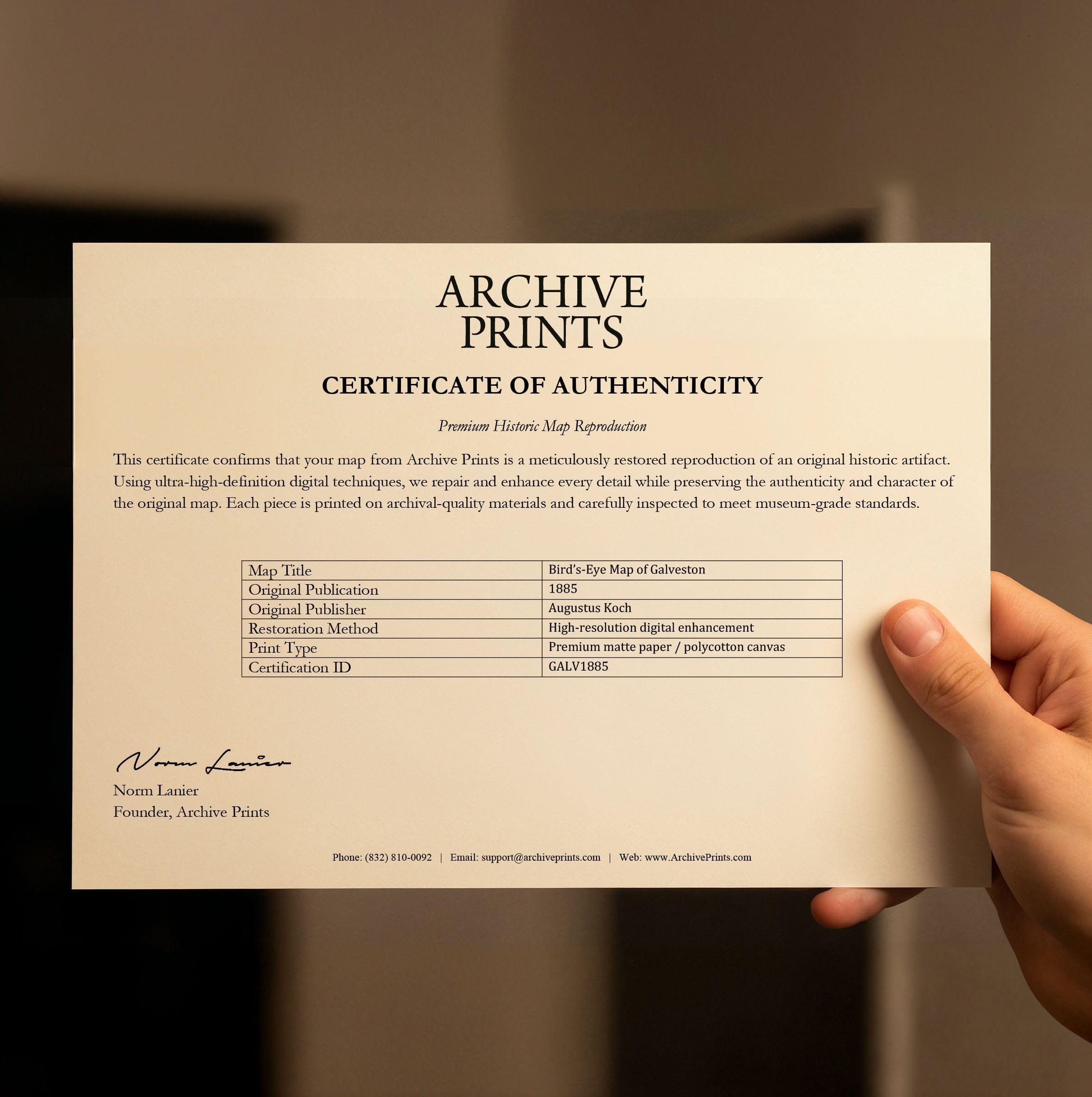
All of our maps are meticulously restored reproductions of historic originals. Each piece is digitally repaired and color-corrected to bring out the finest details while preserving its authentic, vintage character.
Yes. All Archive Prints products are printed to order in the USA with archival materials.
We offer two premium formats:
- High-Quality Paper Posters – Printed on thick, archival-grade matte paper for rich, vibrant detail.
- Hand-Stretched Canvas Prints – Printed on premium polycotton canvas and mounted on 1.5" solid American pine stretcher bars for a gallery-quality finish.
We carefully digitally restore each map to enhance clarity and color while preserving its original look and historic charm. You’ll enjoy sharp details and a timeless vintage aesthetic that feels true to the original piece.
Yes, we do! We offer premium framing options to make your map ready to hang the moment it arrives. You can choose from Oak, Maple, Black, or Walnut frames directly on the product page. We also offer Stretched Canvas prints for a modern gallery look, as well as archival-quality Posters if you prefer to frame it yourself.
Yes! We offer free shipping on all products within the United States. Each map is carefully packaged to ensure it arrives in perfect condition.
If you’re not completely satisfied, you can return your order in new condition for a full refund. Return shipping costs are the responsibility of the customer.
Absolutely! Our maps make thoughtful, one-of-a-kind gifts for history lovers, map collectors, or anyone looking to add vintage character to their home or office. Choose between paper prints for framing or stretched canvas for a ready-to-hang presentation.
- Paper Posters → Shipped in durable, protective tubes to prevent creasing.
- Canvas Prints → Carefully wrapped, padded, and boxed to ensure safe delivery.
Our maps look stunning in a variety of settings, including:
- Living rooms and home offices
- Libraries and studies
- Corporate offices and conference rooms
- Restaurants, cafes, and boutique spaces