


Great Smoky Mountains National Park Map 1940
Great Smoky Mountains National Park Map 1940
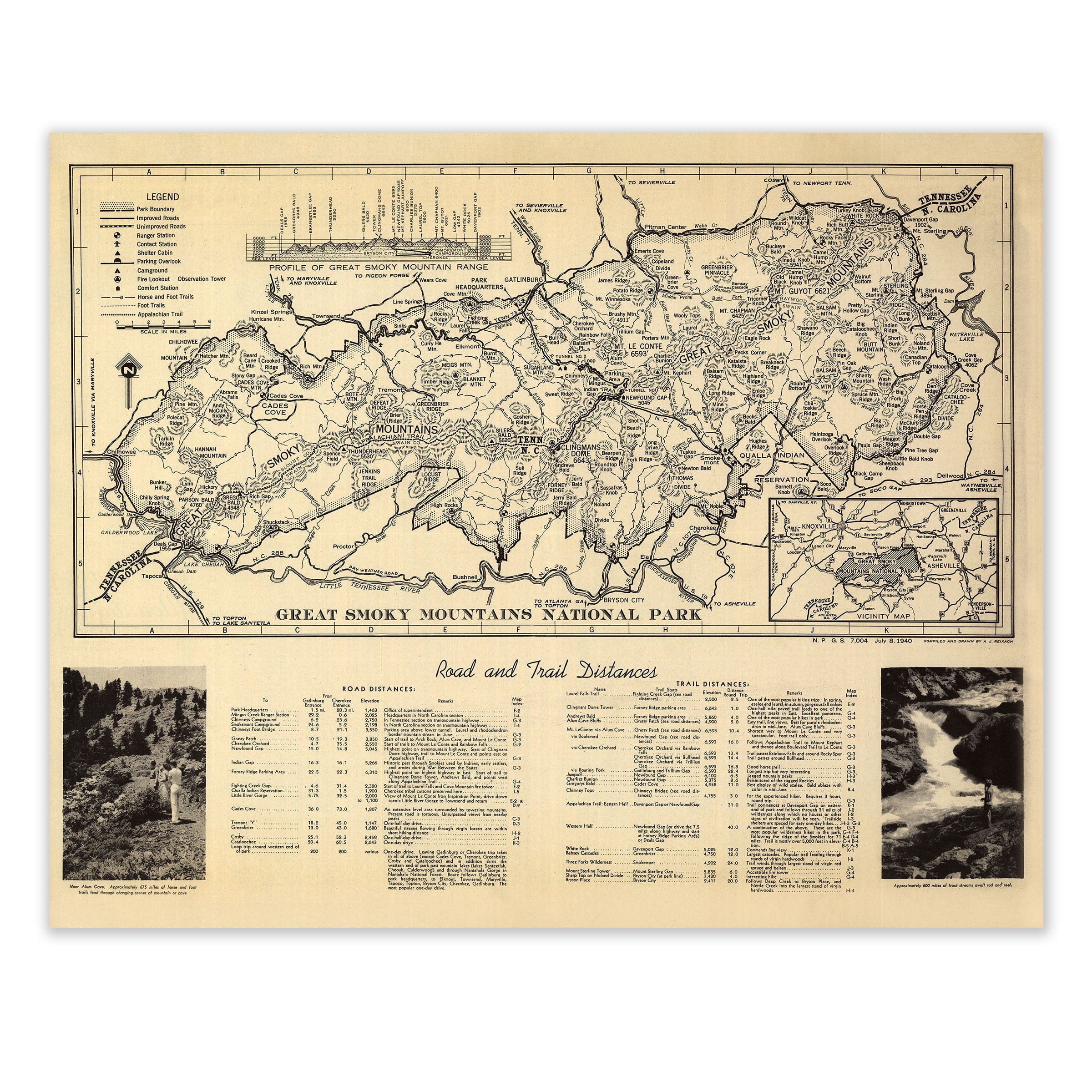
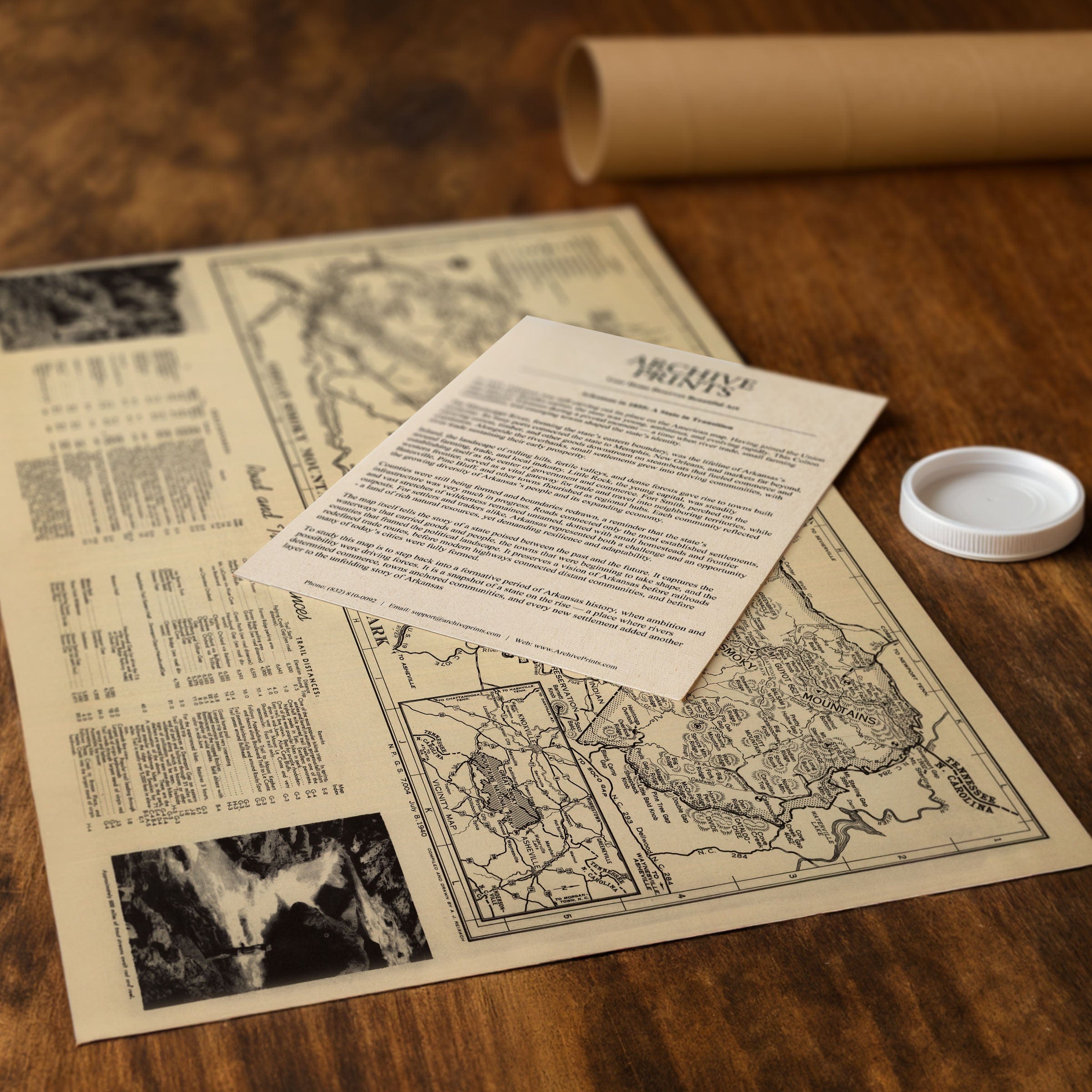
Discover the historic Great Smoky Mountains National Park Map from 1940, capturing the Great Smoky Mountains as one of America's newest national parks—preserved at a moment when wilderness conservation and public access were becoming national priorities. This detailed park map presents the Smokies not as an untamed frontier, but as a carefully protected landscape shaped for exploration, education, and enduring stewardship along the Tennessee–North Carolina border.
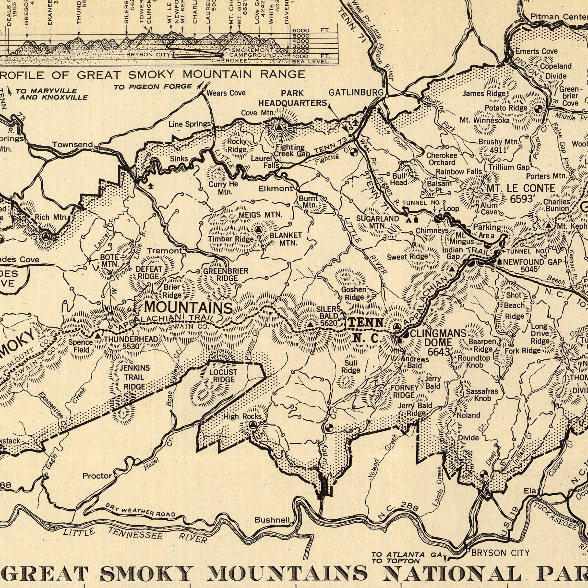
Spanning the crest of the Blue Ridge, this Great Smoky Mountains National Park Map lays out the Smokies from a sweeping perspective. Dense contouring and shaded relief emphasize the dramatic topography—steep ridges, deep coves, and high balds rising toward Clingmans Dome, the highest point in the range. Rivers and streams thread through the valleys, including the Little Tennessee and Oconaluftee, tracing natural corridors that had guided travel long before modern roads arrived.
Roads and trails dominate this Great Smoky Mountains National Park Map's visual language, reflecting the National Park Service's mission to balance access with preservation. Newly improved highways link Gatlinburg, Cherokee, and Bryson City, while fine-lined footpaths mark the growing network of hiking trails. The Appalachian Trail, boldly identified along the mountain crest, stands as a symbolic spine of the eastern wilderness, connecting the Smokies to a broader national vision of long-distance conservation.
Historic place names in this Great Smoky Mountains National Park Map—Cades Cove, Elkmont, Newfound Gap, and Mount Le Conte—anchor the park in human memory. Former logging towns, family cemeteries, and church sites quietly appear, reminders that this protected landscape had once been home to generations of mountain communities. The inclusion of ranger stations, campgrounds, and fire lookout towers reflects an era when forest management was central to park administration.
Perfect for Smoky Mountains visitors, Appalachian history enthusiasts, and collectors of vintage national park maps, this Great Smoky Mountains National Park Map reproduction includes a custom historical certificate. Created just a few years after the park's official dedication, it celebrates the Smokies as a shared national treasure. Printed on heavyweight archival paper or hand-stretched polycotton canvas, every trail, peak, cove, and landmark is restored in museum-grade clarity for generations of enjoyment. Paper prints ship rolled in heavy-duty tubes, while canvas editions arrive gallery-wrapped on solid pine stretcher bars with pre-installed hardware—ready to display the moment it arrives. Bring home a piece of national park history and celebrate the timeless beauty of the Great Smoky Mountains.
The Map Story
Materials
Choose options

Because every place has a story
Make History Personal
A vintage map is more than art.
It is a reminder of where life began.
Where memories were made.
Where hearts still live. Give the gift of place.
Beautifully preserved and made for the moments that matter.
Why Choose Us?
| Feature | Us | Competitor A | Competitor B |
|---|---|---|---|
| Hand Crafted | |||
| Museum Quality | |||
| 100 Year Guarantee | |||
| Restored by Hand | |||
| Certificate of Authenticity |

Art Prints
Archival quality colors. Best option if you'd like to frame it yourself

The Best Materials
We hand-stretched our canvas on solid American-grown pine stretcher bars. We use quality canvas and fade-resistant inks to create the lasting art. Canvases come with hardware already installed and ready to hang.
Need help?
Frequently Asked Questions
Order
All of our maps are meticulously restored reproductions of historic originals. Each piece is digitally repaired and color-corrected to bring out the finest details while preserving its authentic, vintage character.
Yes. All Archive Prints products are printed to order in the USA with archival materials.
We offer two premium formats:
- High-Quality Paper Posters – Printed on thick, archival-grade matte paper for rich, vibrant detail.
- Hand-Stretched Canvas Prints – Printed on premium polycotton canvas and mounted on 1.5" solid American pine stretcher bars for a gallery-quality finish.
We carefully digitally restore each map to enhance clarity and color while preserving its original look and historic charm. You’ll enjoy sharp details and a timeless vintage aesthetic that feels true to the original piece.
Yes, we do! We offer premium framing options to make your map ready to hang the moment it arrives. You can choose from Oak, Maple, Black, or Walnut frames directly on the product page. We also offer Stretched Canvas prints for a modern gallery look, as well as archival-quality Posters if you prefer to frame it yourself.
Yes! We offer free shipping on all products within the United States. Each map is carefully packaged to ensure it arrives in perfect condition.
If you’re not completely satisfied, you can return your order in new condition for a full refund. Return shipping costs are the responsibility of the customer.
Absolutely! Our maps make thoughtful, one-of-a-kind gifts for history lovers, map collectors, or anyone looking to add vintage character to their home or office. Choose between paper prints for framing or stretched canvas for a ready-to-hang presentation.
- Paper Posters → Shipped in durable, protective tubes to prevent creasing.
- Canvas Prints → Carefully wrapped, padded, and boxed to ensure safe delivery.
Our maps look stunning in a variety of settings, including:
- Living rooms and home offices
- Libraries and studies
- Corporate offices and conference rooms
- Restaurants, cafes, and boutique spaces