Greenwich, Connecticut Map 1893
Greenwich, Connecticut Map 1893
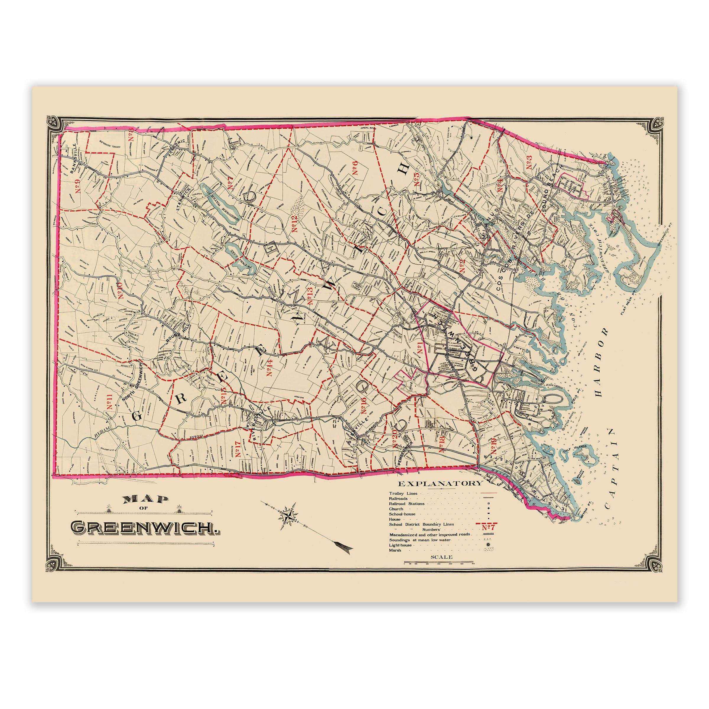
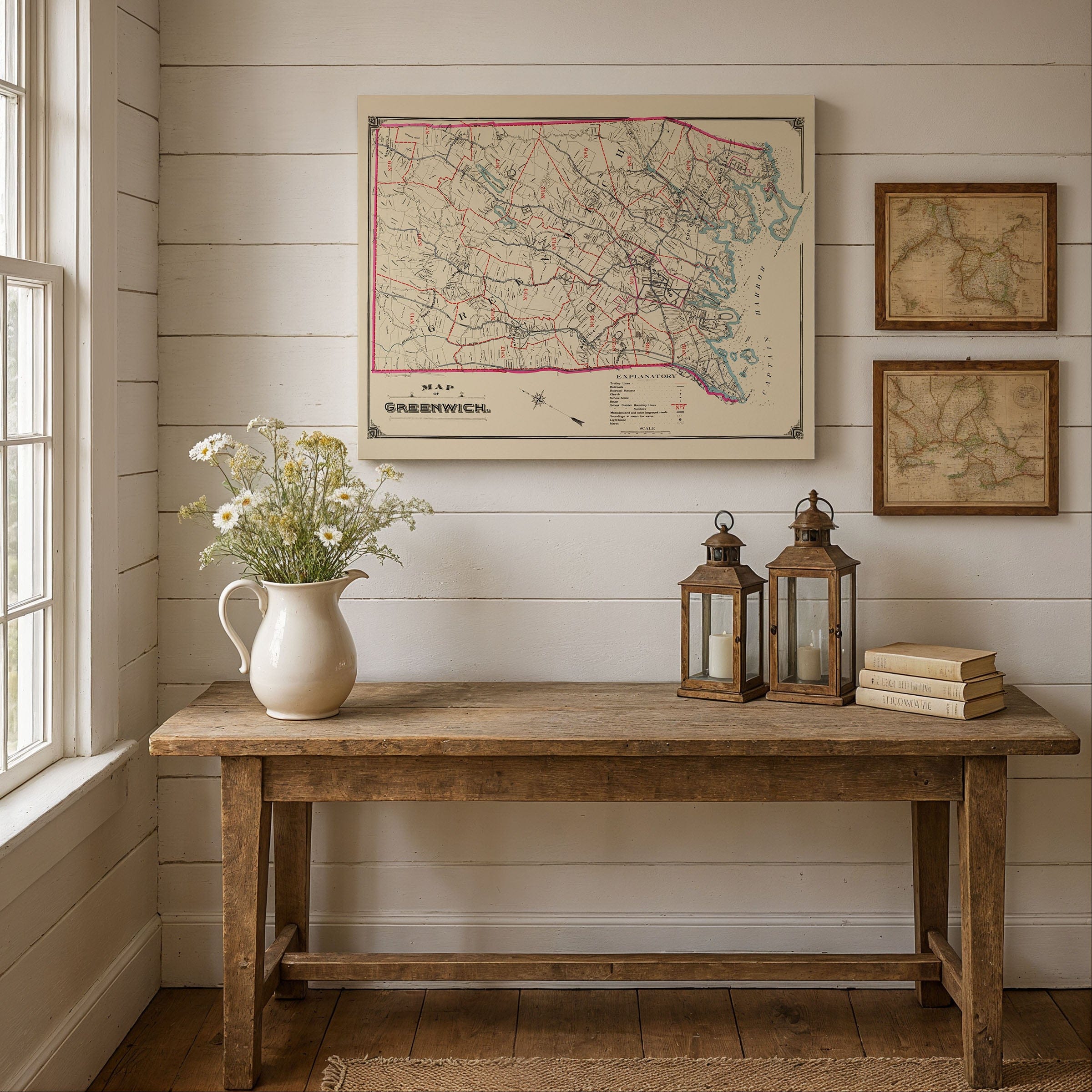
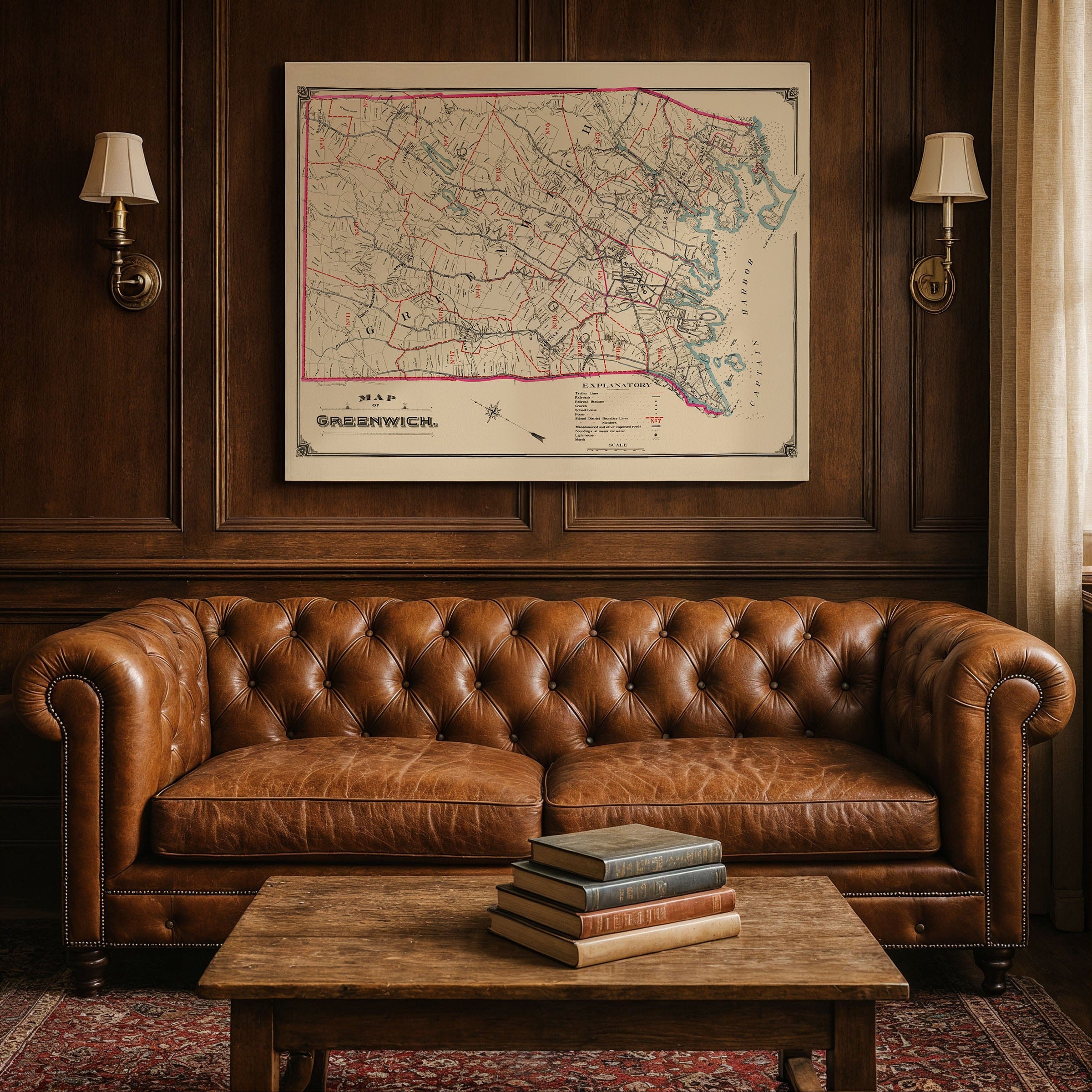
Discover the remarkable Greenwich, Connecticut Map from 1893, capturing Greenwich at the threshold of transformation—shifting from a quiet New England farming community to a prosperous coastal town shaped by railroads, new roads, and the growing influence of nearby New York City. This detailed map preserves Greenwich at that pivotal moment, when traditional rural landscapes overlapped with the first signs of suburban expansion and modern infrastructure that would define this iconic Connecticut town.
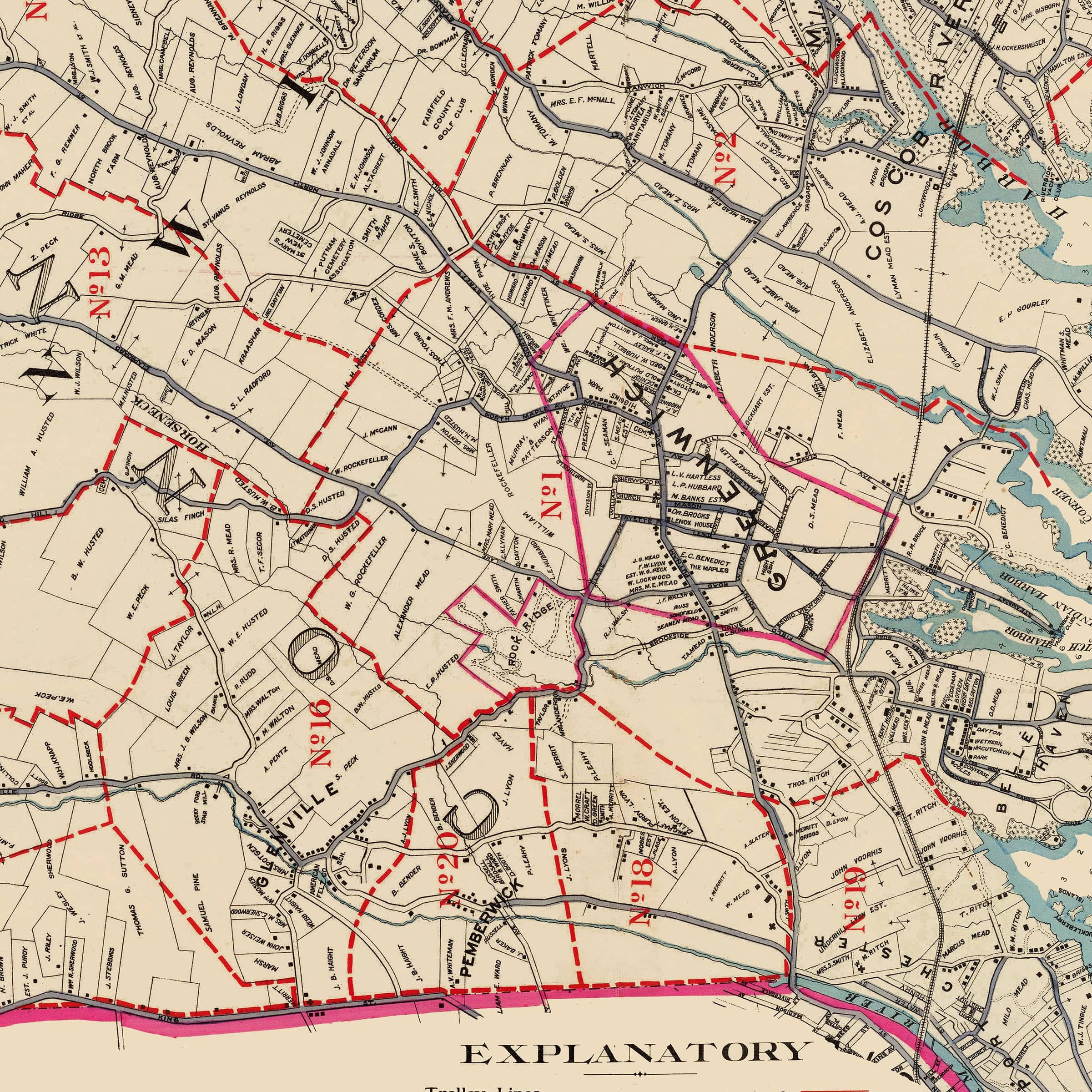
The Greenwich, Connecticut Map reveals a town divided into its historic districts and neighborhoods, each connected by a network of winding country roads, stone-lined property boundaries, and emerging trolley routes. The red lines tracing the school district boundaries speak to a community invested in civic order and education, while the careful placement of churches, schoolhouses, and town institutions reflects the anchors of daily life. The presence of rail stations along the shoreline marks a critical shift—one that tied Greenwich ever more tightly to the bustling markets and workplaces of Manhattan.
The coastline along Captain Harbor in this Greenwich, Connecticut Map is rendered with particular care, showing an intricate pattern of coves, inlets, salt marshes, and islands. These waters shaped much of Greenwich's early economy, from fishing and oystering to ferry connections and coastal trade. By the 1890s, however, the harbor was becoming equally valued for its scenic beauty, attracting summer visitors and inspiring the development of grand estates along the Long Island Sound that would become synonymous with Greenwich's reputation.
Inland, the Greenwich, Connecticut Map shows the town as a tapestry of farms, orchards, and wooded hills. Roads such as King Street, North Street, and Round Hill Road pass through long stretches of rural land, dotted with mills and homesteads that had stood for generations. Yet even here, the map hints at change: improved macadamized roads, newly surveyed tracts, and the extension of utility lines signal the beginning of suburban growth that would accelerate dramatically in the decades to come.
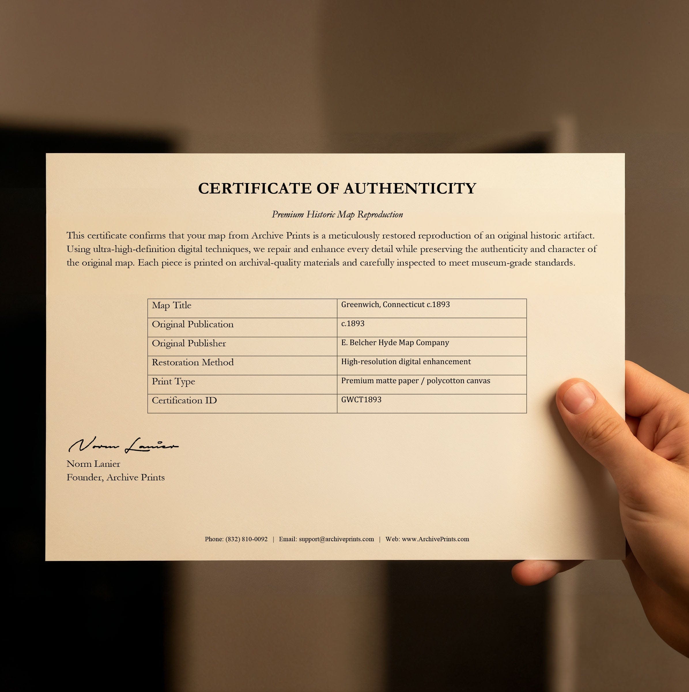
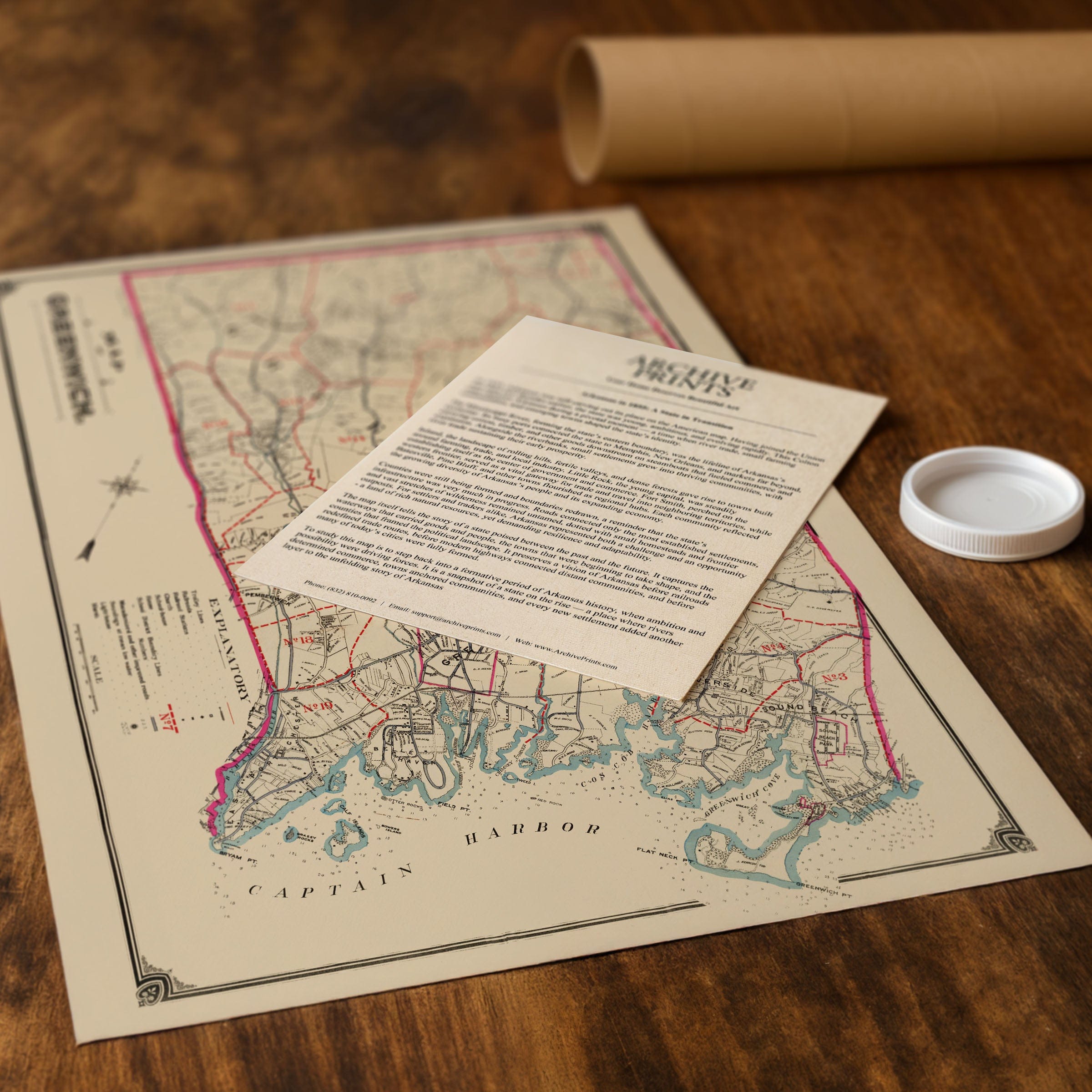
Perfect for Greenwich residents, Connecticut history enthusiasts, and collectors of New England cartography, this Greenwich, Connecticut Map reproduction includes a custom historical certificate. The map captures the administrative precision of the era—from trolley lines and improved highways to school districts and railroad spurs, every element is cataloged in the explanatory key, demonstrating the work of a community preparing for modernization while still grounded in its agrarian past. Printed on heavyweight archival paper or hand-stretched polycotton canvas, every road, property line, and coastal detail is restored in museum-grade clarity for generations of enjoyment. Paper prints ship rolled in heavy-duty tubes, while canvas editions arrive gallery-wrapped on solid pine stretcher bars with pre-installed hardware—ready to display the moment it arrives. Bring home a piece of Greenwich heritage and celebrate a town at the crossroads of eras.
The Map Story
Drawn with precision, the map reveals a town divided into its historic districts and neighborhoods, each connected by a network of winding country roads, stone-lined property boundaries, and emerging trolley routes. The red lines tracing the school district boundaries speak to a community invested in civic order and education, while the careful placement of churches, schoolhouses, and town institutions reflects the anchors of daily life. At the same time, the presence of rail stations along the shoreline marks a critical shift—one that tied Greenwich ever more tightly to the bustling markets and workplaces of Manhattan.
The coastline along Captain Harbor is rendered with particular care, showing an intricate pattern of coves, inlets, salt marshes, and islands. These waters shaped much of Greenwich's early economy, from fishing and oystering to ferry connections and coastal trade. By the 1890s, however, the harbor was becoming equally valued for its scenic beauty, attracting summer visitors and inspiring the development of estates along the Long Island Sound.
Inland, the town remains a tapestry of farms, orchards, and wooded hills. Roads such as King Street, North Street, and Round Hill Road pass through long stretches of rural land, dotted with mills and homesteads that had stood for generations. Yet even here, the map hints at change: improved macadamized roads, newly surveyed tracts, and the extension of utility lines signal the beginning of suburban growth that would accelerate in the decades to come.
This map also captures the administrative precision of the era. From trolley lines and improved highways to school districts and railroad spurs, every element is cataloged in the explanatory key, demonstrating the work of a community preparing for modernization while still grounded in its agrarian past.
The Map of Greenwich preserves a town at the crossroads of eras—quiet yet increasingly connected, rural yet on the edge of metropolitan influence. It invites the viewer to explore a landscape where coastal charm, agricultural heritage, and emerging suburban life blended into a unique identity that continues to shape Greenwich today.
Materials
Choose options

Because every place has a story
Make History Personal
A vintage map is more than art.
It is a reminder of where life began.
Where memories were made.
Where hearts still live. Give the gift of place.
Beautifully preserved and made for the moments that matter.
Why Choose Us?
| Feature | Us | Competitor A | Competitor B |
|---|---|---|---|
| Hand Crafted | |||
| Museum Quality | |||
| 100 Year Guarantee | |||
| Restored by Hand | |||
| Certificate of Authenticity |

Art Prints
Archival quality colors. Best option if you'd like to frame it yourself

The Best Materials
We hand-stretched our canvas on solid American-grown pine stretcher bars. We use quality canvas and fade-resistant inks to create the lasting art. Canvases come with hardware already installed and ready to hang.
Need help?
Frequently Asked Questions
Order
All of our maps are meticulously restored reproductions of historic originals. Each piece is digitally repaired and color-corrected to bring out the finest details while preserving its authentic, vintage character.
Yes. All Archive Prints products are printed to order in the USA with archival materials.
We offer two premium formats:
- High-Quality Paper Posters – Printed on thick, archival-grade matte paper for rich, vibrant detail.
- Hand-Stretched Canvas Prints – Printed on premium polycotton canvas and mounted on 1.5" solid American pine stretcher bars for a gallery-quality finish.
We carefully digitally restore each map to enhance clarity and color while preserving its original look and historic charm. You’ll enjoy sharp details and a timeless vintage aesthetic that feels true to the original piece.
Yes, we do! We offer premium framing options to make your map ready to hang the moment it arrives. You can choose from Oak, Maple, Black, or Walnut frames directly on the product page. We also offer Stretched Canvas prints for a modern gallery look, as well as archival-quality Posters if you prefer to frame it yourself.
Yes! We offer free shipping on all products within the United States. Each map is carefully packaged to ensure it arrives in perfect condition.
If you’re not completely satisfied, you can return your order in new condition for a full refund. Return shipping costs are the responsibility of the customer.
Absolutely! Our maps make thoughtful, one-of-a-kind gifts for history lovers, map collectors, or anyone looking to add vintage character to their home or office. Choose between paper prints for framing or stretched canvas for a ready-to-hang presentation.
- Paper Posters → Shipped in durable, protective tubes to prevent creasing.
- Canvas Prints → Carefully wrapped, padded, and boxed to ensure safe delivery.
Our maps look stunning in a variety of settings, including:
- Living rooms and home offices
- Libraries and studies
- Corporate offices and conference rooms
- Restaurants, cafes, and boutique spaces