

Hoboken, New Jersey Map 1904
Hoboken, New Jersey Map 1904
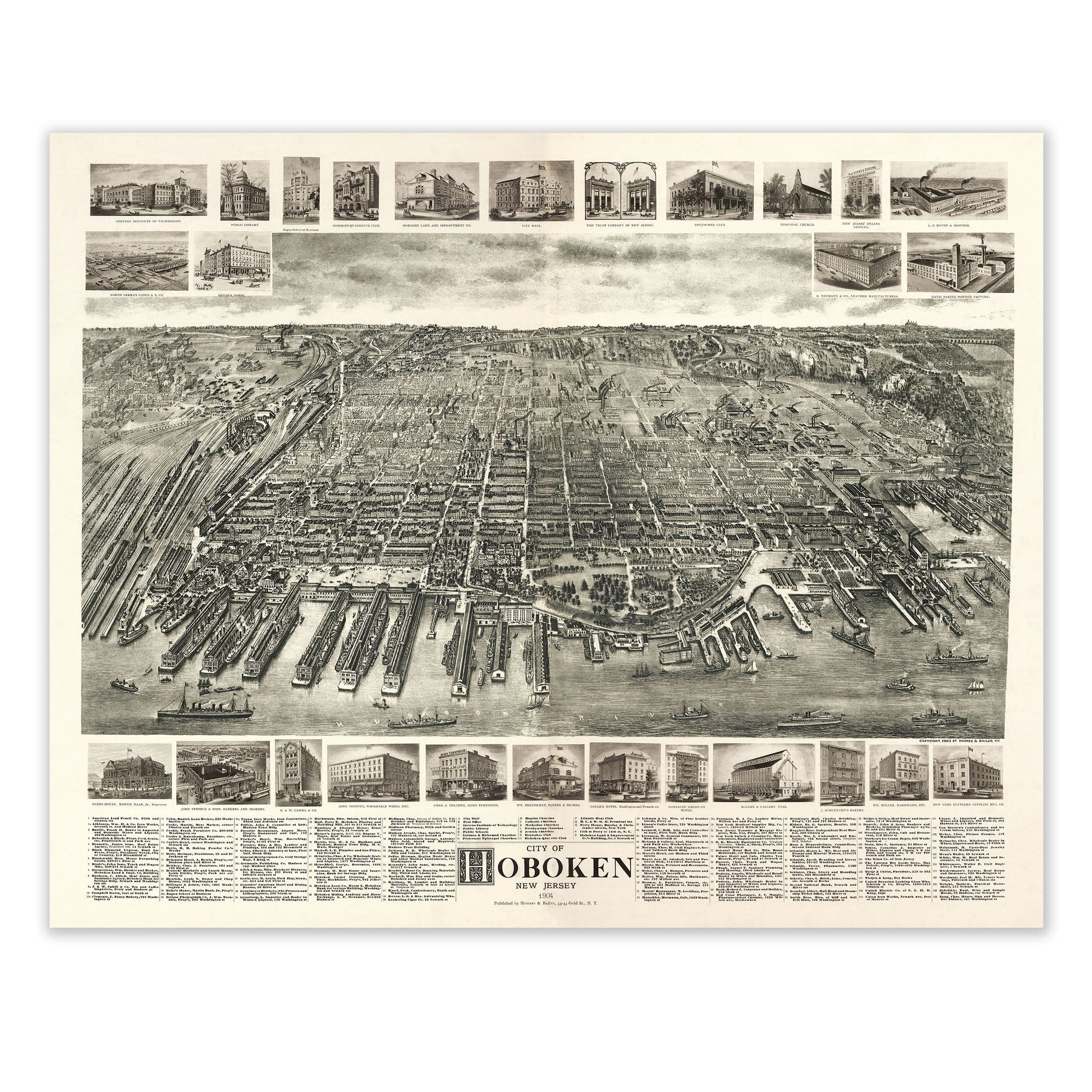
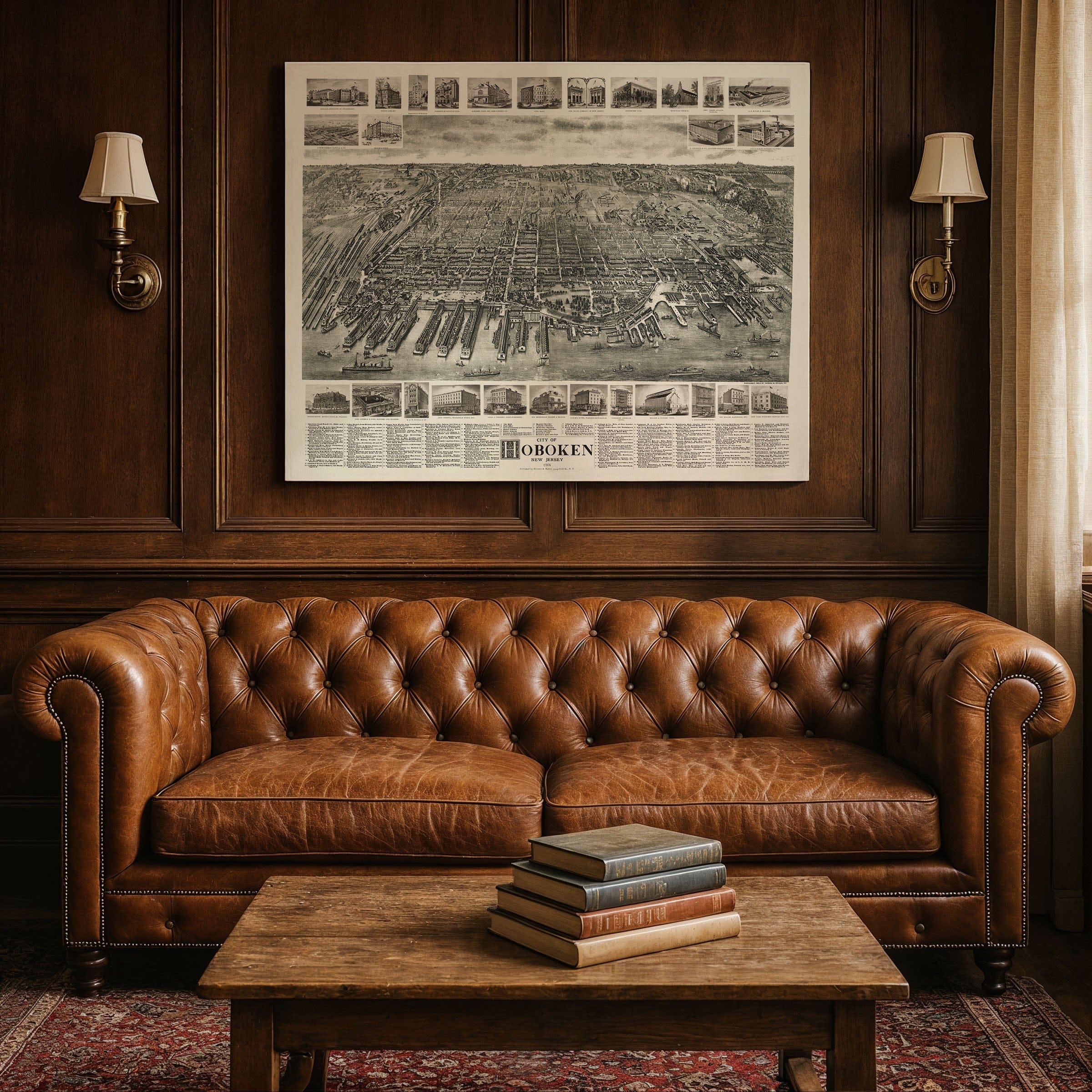
Discover the remarkable Hoboken, New Jersey Map from 1904, capturing Hoboken at the height of its early-20th-century vitality as one of the busiest and most strategically important waterfront cities on the Atlantic seaboard. This panoramic bird's-eye view preserves a place where immigration, industry, and transportation converged in a dense and energetic urban landscape, when railroads, ocean liners, and manufacturing shaped the rhythm of life along the Hudson River.
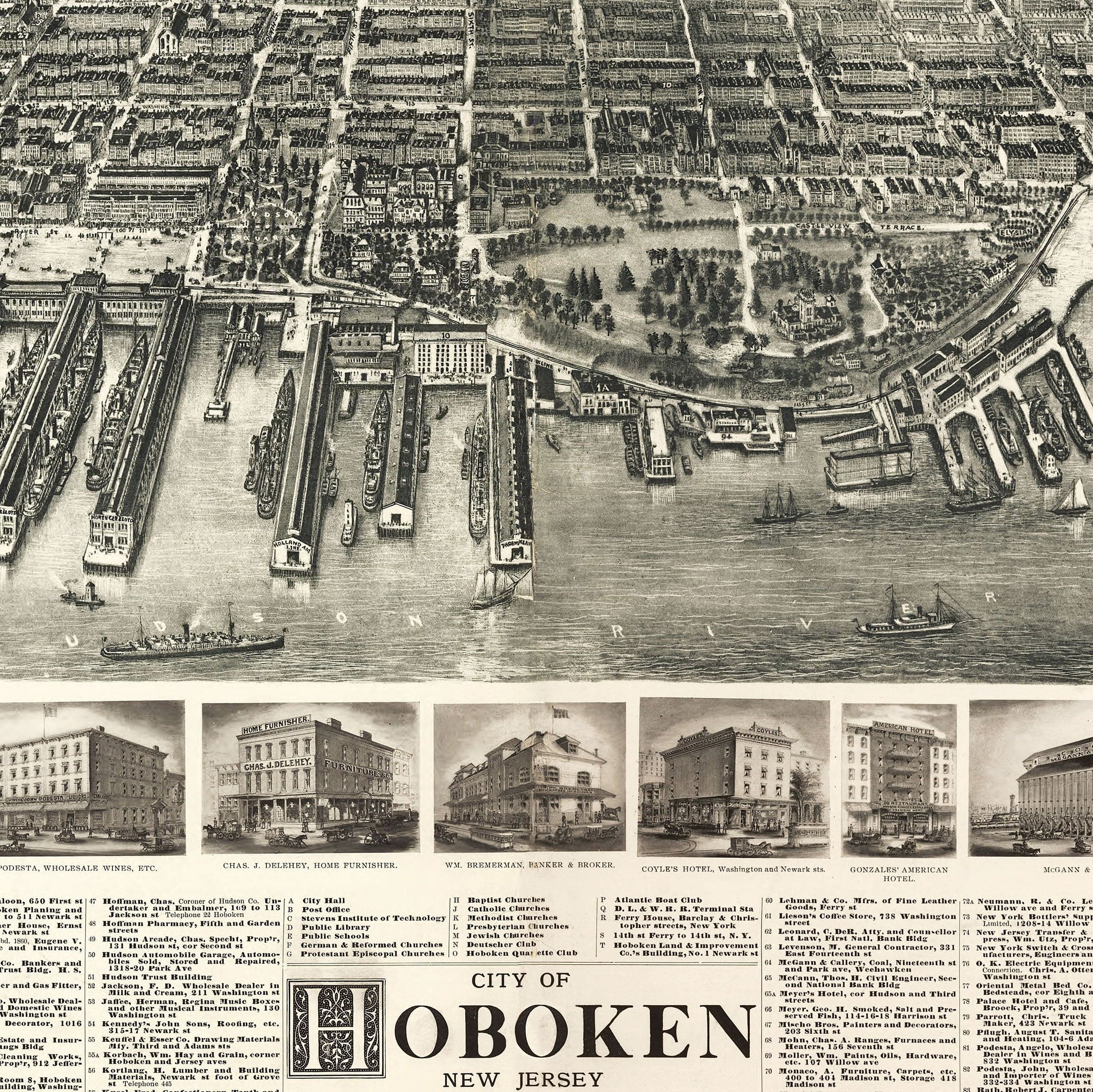
Viewed from across the water, this Hoboken, New Jersey Map reveals a striking grid of tightly packed streets stretching inland from a waterfront alive with activity. Endless piers extend into the Hudson River like steel-toothed combs, each one crowded with steamships, barges, lighters, and ferries. The great transatlantic lines maintained their terminals here, carrying thousands of immigrants and travelers each week. Hoboken's role as a major gateway to America is unmistakable—its waterfront a constant churn of cargo, passengers, and maritime commerce.
The Hoboken, New Jersey Map prominently features the sprawling rail yards of the Delaware, Lackawanna & Western Railroad dominating the scene. Tracks crisscross the landscape in a vast metallic web, converging at the Hoboken Terminal, which served as the primary portal linking New York City with the expanding railroad networks of the interior. This was the city's industrial engine, where freight cars arrived from Pennsylvania coalfields, Midwestern mills, and New Jersey factories before transferring their loads to ships bound for distant ports.
Inland, this Hoboken, New Jersey Map shows the dense urban fabric of Hoboken unfolding in neat blocks of rowhouses, workshops, schools, and churches. The map's vignette illustrations highlight the city's civic and commercial pride—hotels, banks, breweries, clubs, and schools that formed the backbone of local life. German-American culture was especially prominent in these years, shaping everything from architecture to neighborhood institutions. Washington Street, Hoboken's commercial spine, runs straight and lively through the center, lined with shops, streetcars, and bustling pedestrians.
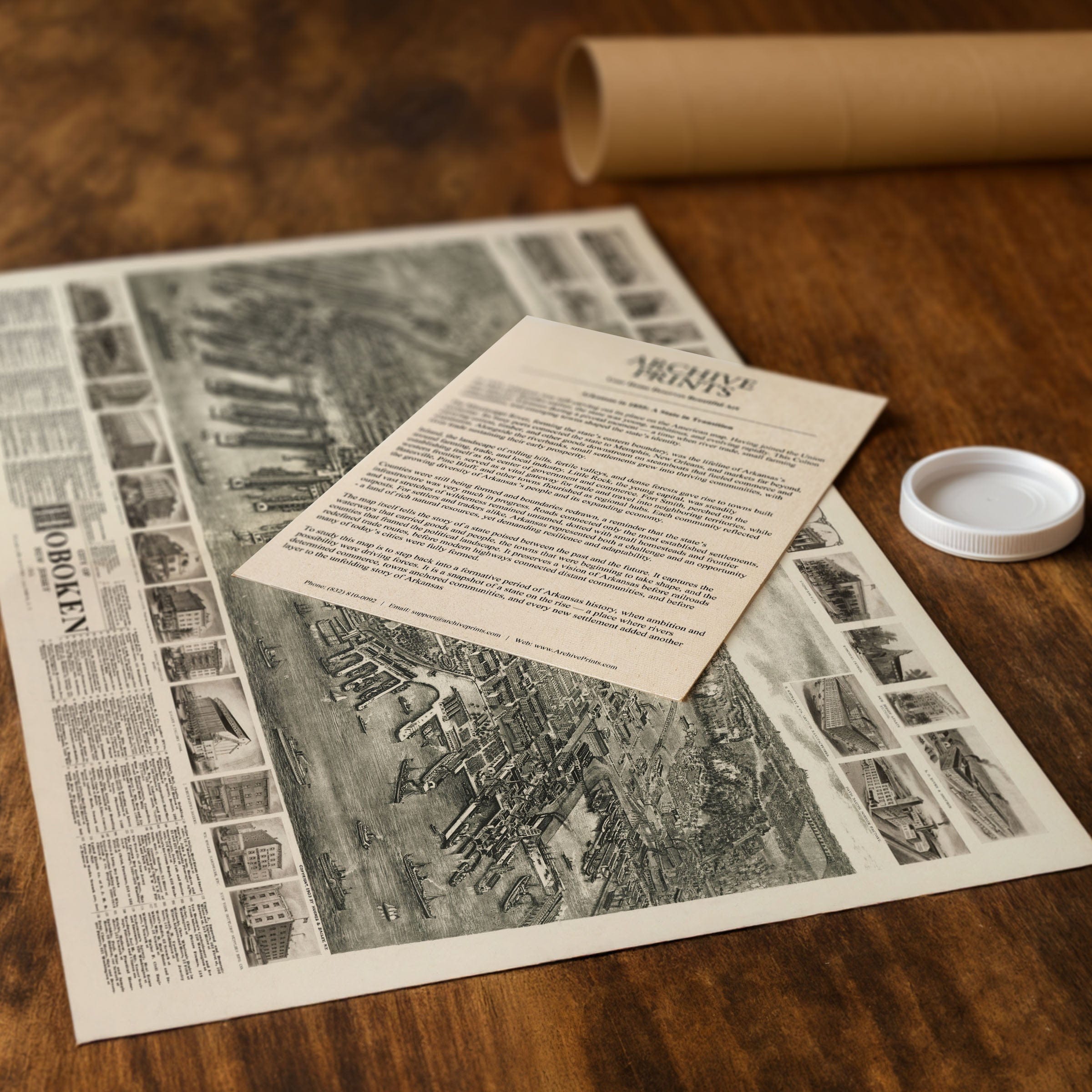
Perfect for Hoboken residents, New Jersey history enthusiasts, and collectors of Hudson River heritage, this Hoboken, New Jersey Map reproduction includes a custom historical certificate. By 1904, Hoboken was a city in full motion—one of the great transportation hubs of the era, humming with energy and ambition. Printed on heavyweight archival paper or hand-stretched polycotton canvas, every pier, rail yard, street, and vignette is restored in museum-grade clarity for generations of enjoyment. Paper prints ship rolled in heavy-duty tubes, while canvas editions arrive gallery-wrapped on solid pine stretcher bars with pre-installed hardware—ready to display the moment it arrives. Bring home a piece of Hoboken history and celebrate a waterfront metropolis whose identity was forged by ships, rails, and commerce.
The Map Story
Viewed from across the water, the map reveals a striking grid of tightly packed streets stretching inland from a waterfront alive with activity. Endless piers extend into the river like steel-toothed combs, each one crowded with steamships, barges, lighters, and ferries. Here, the great transatlantic lines maintained their terminals, carrying thousands of immigrants and travelers each week. Hoboken's role as a major gateway to the nation is unmistakable—its waterfront a constant churn of cargo, passengers, and maritime commerce.
To the left, the sprawling rail yards of the Delaware, Lackawanna & Western Railroad dominate the scene. Tracks crisscross the landscape in a vast metallic web, converging at the Hoboken Terminal, which served as the primary portal linking New York City with the expanding railroad networks of the interior. This was the city's industrial engine, where freight cars arrived from Pennsylvania coalfields, Midwestern mills, and New Jersey factories before transferring their loads to ships bound for distant ports.
Inland, the dense urban fabric of Hoboken unfolds in neat blocks of rowhouses, workshops, schools, and churches. The map's vignette illustrations highlight the city's civic and commercial pride—hotels, banks, breweries, clubs, and schools that formed the backbone of local life. German-American culture was especially prominent in these years, shaping everything from architecture to neighborhood institutions.
Washington Street, Hoboken's commercial spine, runs straight and lively through the center, lined with shops, streetcars, and pedestrians. To the north and west, the city rises gently toward the cliffs of the New Jersey Palisades, where the Grading and Heights Commission had begun transforming the upland terrain with tunnels and new streets.
By 1904, Hoboken was a city in full motion—one of the great transportation hubs of the era, humming with energy and ambition. This map freezes that moment in exquisite detail, capturing a waterfront metropolis whose identity was forged by ships, rails, and the relentless currents of commerce. It invites the viewer to step into a city that helped carry America into the modern industrial age.
Materials
Choose options

Because every place has a story
Make History Personal
A vintage map is more than art.
It is a reminder of where life began.
Where memories were made.
Where hearts still live. Give the gift of place.
Beautifully preserved and made for the moments that matter.
Why Choose Us?
| Feature | Us | Competitor A | Competitor B |
|---|---|---|---|
| Hand Crafted | |||
| Museum Quality | |||
| 100 Year Guarantee | |||
| Restored by Hand | |||
| Certificate of Authenticity |

Art Prints
Archival quality colors. Best option if you'd like to frame it yourself

The Best Materials
We hand-stretched our canvas on solid American-grown pine stretcher bars. We use quality canvas and fade-resistant inks to create the lasting art. Canvases come with hardware already installed and ready to hang.
Need help?
Frequently Asked Questions
Order
All of our maps are meticulously restored reproductions of historic originals. Each piece is digitally repaired and color-corrected to bring out the finest details while preserving its authentic, vintage character.
Yes. All Archive Prints products are printed to order in the USA with archival materials.
We offer two premium formats:
- High-Quality Paper Posters – Printed on thick, archival-grade matte paper for rich, vibrant detail.
- Hand-Stretched Canvas Prints – Printed on premium polycotton canvas and mounted on 1.5" solid American pine stretcher bars for a gallery-quality finish.
We carefully digitally restore each map to enhance clarity and color while preserving its original look and historic charm. You’ll enjoy sharp details and a timeless vintage aesthetic that feels true to the original piece.
Yes, we do! We offer premium framing options to make your map ready to hang the moment it arrives. You can choose from Oak, Maple, Black, or Walnut frames directly on the product page. We also offer Stretched Canvas prints for a modern gallery look, as well as archival-quality Posters if you prefer to frame it yourself.
Yes! We offer free shipping on all products within the United States. Each map is carefully packaged to ensure it arrives in perfect condition.
If you’re not completely satisfied, you can return your order in new condition for a full refund. Return shipping costs are the responsibility of the customer.
Absolutely! Our maps make thoughtful, one-of-a-kind gifts for history lovers, map collectors, or anyone looking to add vintage character to their home or office. Choose between paper prints for framing or stretched canvas for a ready-to-hang presentation.
- Paper Posters → Shipped in durable, protective tubes to prevent creasing.
- Canvas Prints → Carefully wrapped, padded, and boxed to ensure safe delivery.
Our maps look stunning in a variety of settings, including:
- Living rooms and home offices
- Libraries and studies
- Corporate offices and conference rooms
- Restaurants, cafes, and boutique spaces