
Houston, Texas Map 1891
Houston, Texas Map 1891
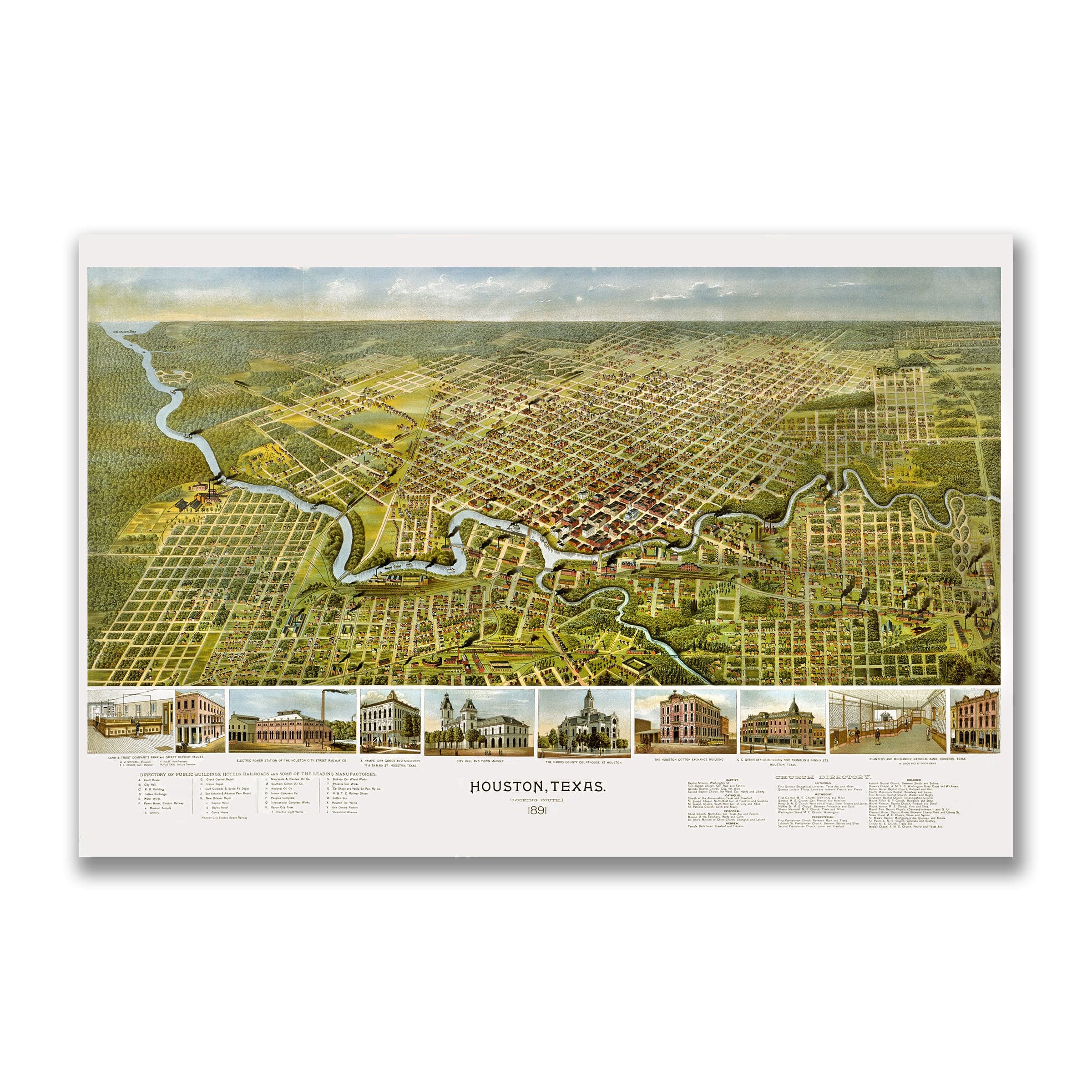
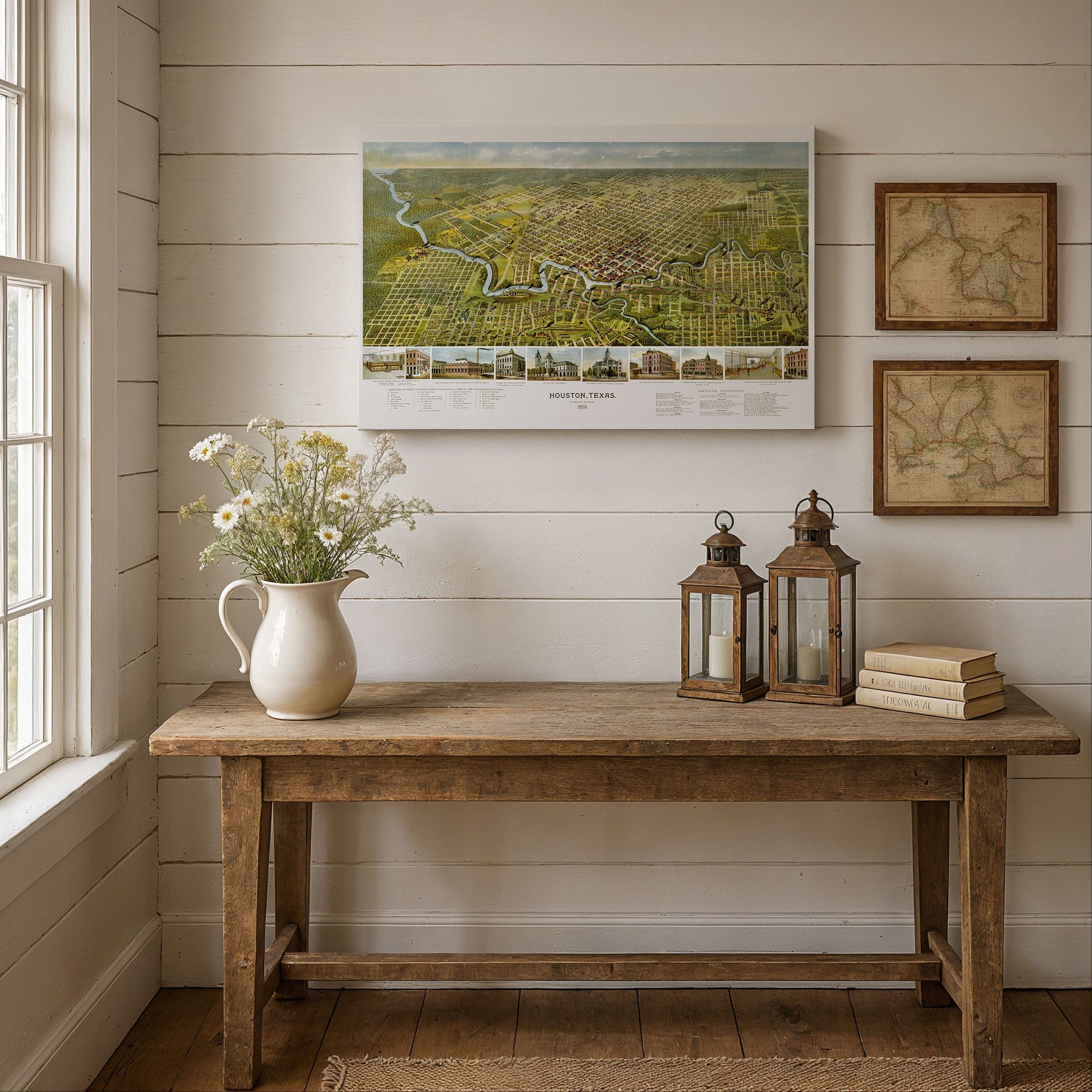
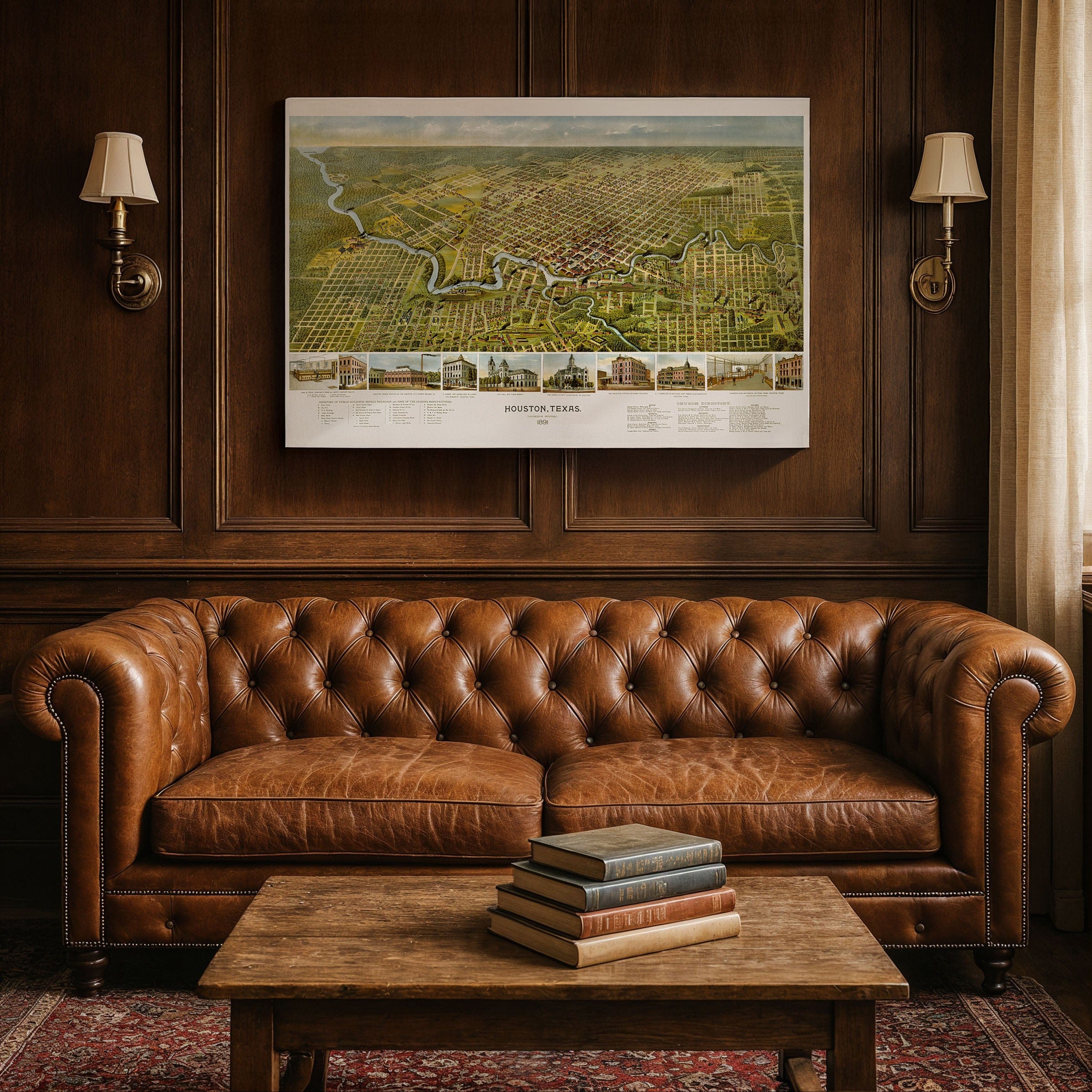
Discover the exceptional Houston, Texas Map by Augustus Koch, capturing Houston in 1891 as a young but rapidly ascending city—an energetic crossroads of railroads, cotton, and commerce poised to become one of the South's great urban centers. This panoramic bird's-eye view preserves Houston at a defining moment, when its ambitions were beginning to stretch far beyond the muddy banks of Buffalo Bayou and the pine forests surrounding it.
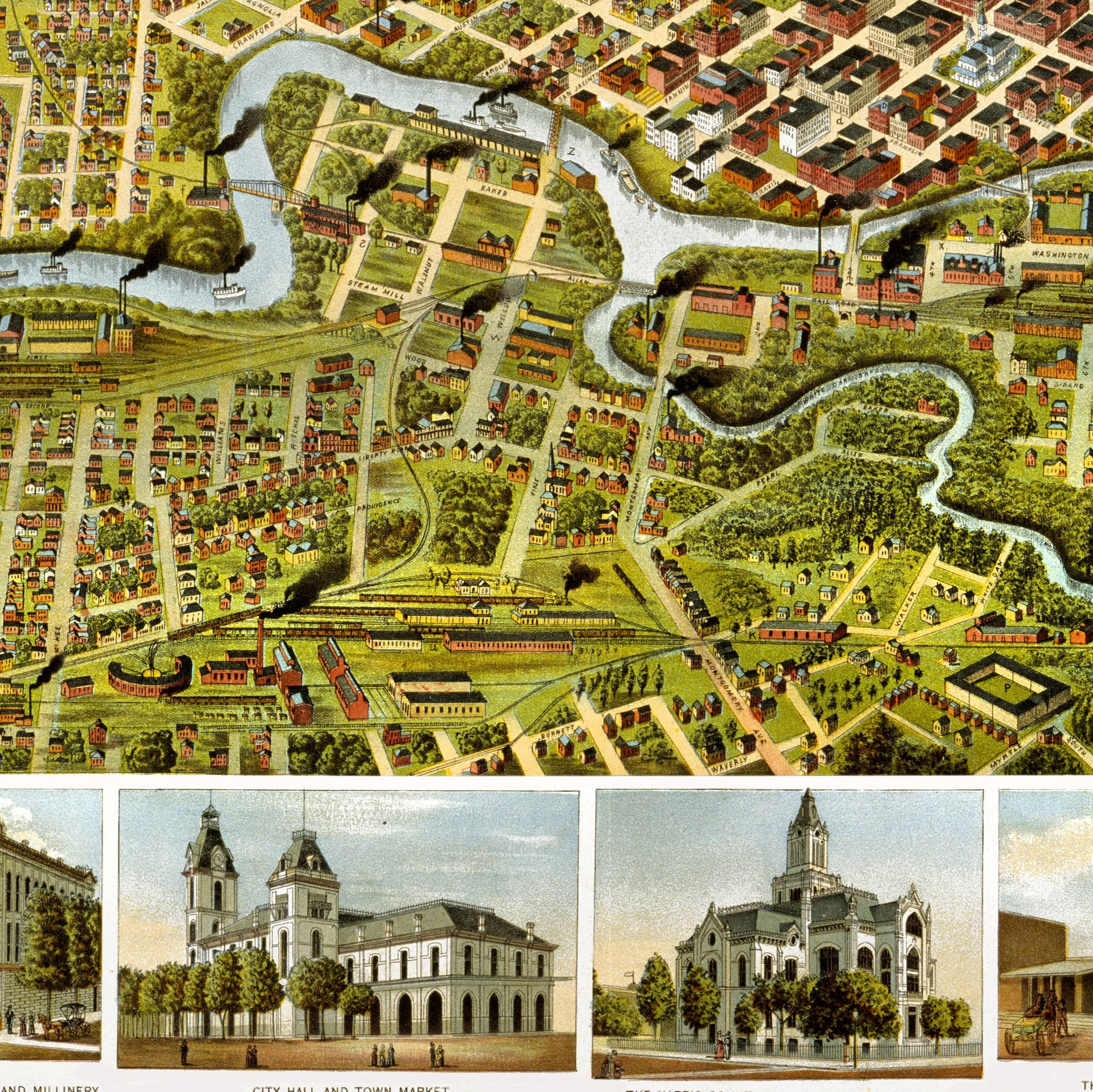
The Houston, Texas Map looks southeast across a sprawling grid that radiates from the winding Buffalo Bayou, whose serpentine path shaped the early city's growth. Bridges, warehouses, and wharves line its edges, testifying to the bayou's pivotal role as Houston's earliest commercial artery. Though shallow and narrow, it had long connected the settlement to Galveston Bay, enabling a lively trade in cotton, lumber, and agricultural goods. By the 1890s, efforts to deepen the waterway foreshadowed Houston's future as a major international port.
Downtown Houston in this Houston, Texas Map forms a dense core of brick blocks and bustling streets—Congress, Main, Preston—where merchants, banks, and cotton brokers conducted business in an atmosphere of constant movement. Factories and mills cluster near the rail lines, their smokestacks signaling the rise of industry. Houston's rail network, one of the most extensive in the region, dominates the lower portion: converging tracks, depots, and yards illustrate why the city had become a major hub linking Texas to New Orleans, St. Louis, and the rest of the nation.
The Houston, Texas Map shows neighborhoods stretching outward in every direction, marked by rows of modest homes shaded by wide, tree-lined streets. Churches, schools, and civic buildings anchor each ward, reflecting a community investing in culture and stability. The map's illustrated border showcases Houston's pride—its courthouses, cotton exchange, city hall, opera house, and other major institutions, each symbolizing the city's growing stature. Even the open lands beyond the city grid hint at the scale of what was coming, with vacant tracts suggesting a city ready to burst outward.
Perfect for Houston residents, Texas history enthusiasts, and collectors of Southern urban cartography, this Houston, Texas Map reproduction includes a custom historical certificate. At the time of this map, Houston's population had surpassed 27,000 and was rising steadily, driven by railroads, cotton, and the belief that the city was destined for far more. Printed on heavyweight archival paper or hand-stretched polycotton canvas, every street, rail line, building, and bayou bend is restored in museum-grade clarity for generations of enjoyment. Paper prints ship rolled in heavy-duty tubes, while canvas editions arrive gallery-wrapped on solid pine stretcher bars with pre-installed hardware—ready to display the moment it arrives. Bring home a piece of Houston history and celebrate a city poised between frontier beginnings and metropolitan greatness.
The Map Story
The view looks southeast across a sprawling grid that radiates from the winding bayou, whose serpentine path shaped the early city's growth. Bridges, warehouses, and wharves line its edges, testifying to the bayou's pivotal role as Houston's earliest commercial artery. Though shallow and narrow, it had long connected the settlement to Galveston Bay, enabling a lively trade in cotton, lumber, and agricultural goods. By the 1890s, efforts to deepen the waterway foreshadowed Houston's future as a major port.
Downtown forms a dense core of brick blocks and bustling streets—Congress, Main, Preston—where merchants, banks, and cotton brokers conducted business in an atmosphere of constant movement. Factories and mills cluster near the rail lines, their smokestacks signaling the rise of industry. Houston's rail network, one of the most extensive in the region, dominates the lower portion of the map: converging tracks, depots, and yards illustrate why the city had become a major hub linking Texas to New Orleans, St. Louis, and the rest of the nation.
Neighborhoods stretch outward in every direction, marked by rows of modest homes shaded by wide, tree-lined streets. Churches, schools, and civic buildings anchor each ward, reflecting a community investing in culture and stability. The map's illustrated border showcases Houston's pride—its courthouses, cotton exchange, city hall, opera house, and other major institutions, each symbolizing the city's growing stature.
Even the open lands beyond the city grid hint at the scale of what was coming. Vacant tracts and sparsely settled edges suggest a city ready to burst outward, fueled by commerce and migration. At the time of this map, Houston's population had surpassed 27,000 and was rising steadily, driven by railroads, cotton, and the belief that the city was destined for far more.
Augustus Koch's drawing preserves Houston at a remarkable turning point—still defined by its bayou roots yet already pulsing with metropolitan energy. His map invites the viewer to step into a city on the rise, poised between its frontier beginnings and the expansive future that would soon make it one of America's great urban success stories.
Materials
Choose options

Because every place has a story
Make History Personal
A vintage map is more than art.
It is a reminder of where life began.
Where memories were made.
Where hearts still live. Give the gift of place.
Beautifully preserved and made for the moments that matter.
Why Choose Us?
| Feature | Us | Competitor A | Competitor B |
|---|---|---|---|
| Hand Crafted | |||
| Museum Quality | |||
| 100 Year Guarantee | |||
| Restored by Hand | |||
| Certificate of Authenticity |

Art Prints
Archival quality colors. Best option if you'd like to frame it yourself

The Best Materials
We hand-stretched our canvas on solid American-grown pine stretcher bars. We use quality canvas and fade-resistant inks to create the lasting art. Canvases come with hardware already installed and ready to hang.
Need help?
Frequently Asked Questions
Order
All of our maps are meticulously restored reproductions of historic originals. Each piece is digitally repaired and color-corrected to bring out the finest details while preserving its authentic, vintage character.
Yes. All Archive Prints products are printed to order in the USA with archival materials.
We offer two premium formats:
- High-Quality Paper Posters – Printed on thick, archival-grade matte paper for rich, vibrant detail.
- Hand-Stretched Canvas Prints – Printed on premium polycotton canvas and mounted on 1.5" solid American pine stretcher bars for a gallery-quality finish.
We carefully digitally restore each map to enhance clarity and color while preserving its original look and historic charm. You’ll enjoy sharp details and a timeless vintage aesthetic that feels true to the original piece.
Yes, we do! We offer premium framing options to make your map ready to hang the moment it arrives. You can choose from Oak, Maple, Black, or Walnut frames directly on the product page. We also offer Stretched Canvas prints for a modern gallery look, as well as archival-quality Posters if you prefer to frame it yourself.
Yes! We offer free shipping on all products within the United States. Each map is carefully packaged to ensure it arrives in perfect condition.
If you’re not completely satisfied, you can return your order in new condition for a full refund. Return shipping costs are the responsibility of the customer.
Absolutely! Our maps make thoughtful, one-of-a-kind gifts for history lovers, map collectors, or anyone looking to add vintage character to their home or office. Choose between paper prints for framing or stretched canvas for a ready-to-hang presentation.
- Paper Posters → Shipped in durable, protective tubes to prevent creasing.
- Canvas Prints → Carefully wrapped, padded, and boxed to ensure safe delivery.
Our maps look stunning in a variety of settings, including:
- Living rooms and home offices
- Libraries and studies
- Corporate offices and conference rooms
- Restaurants, cafes, and boutique spaces