Idaho Map 1935
Idaho Map 1935
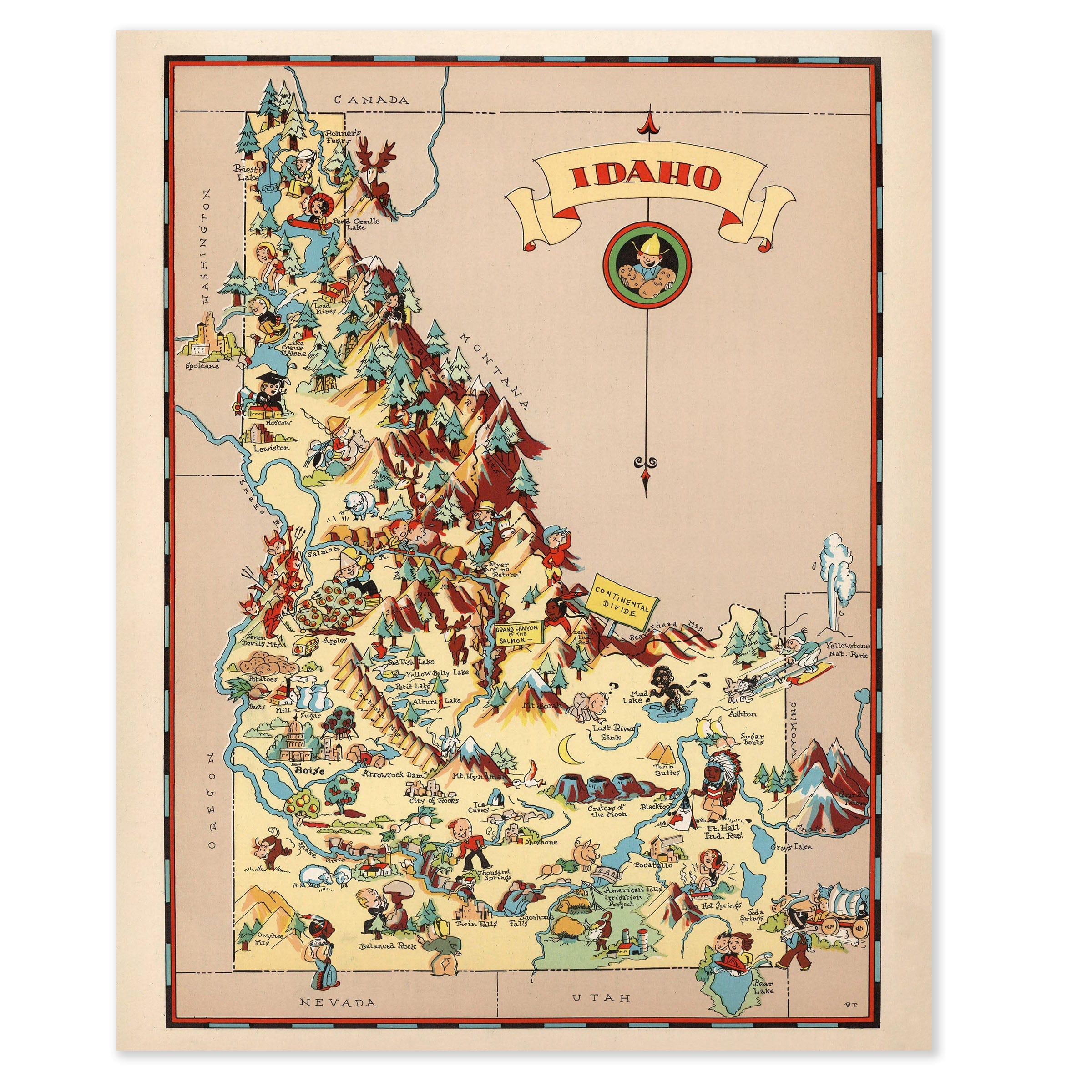
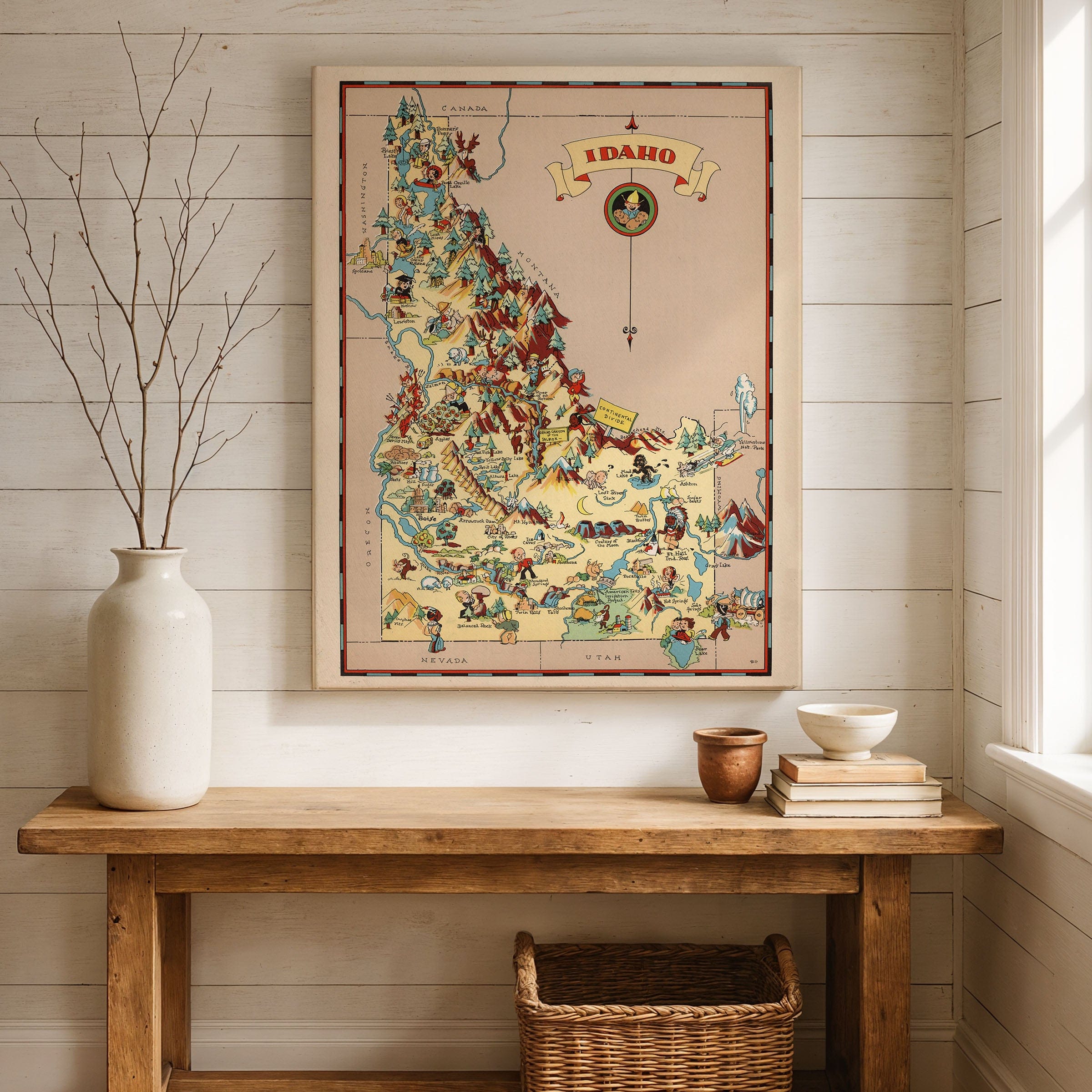
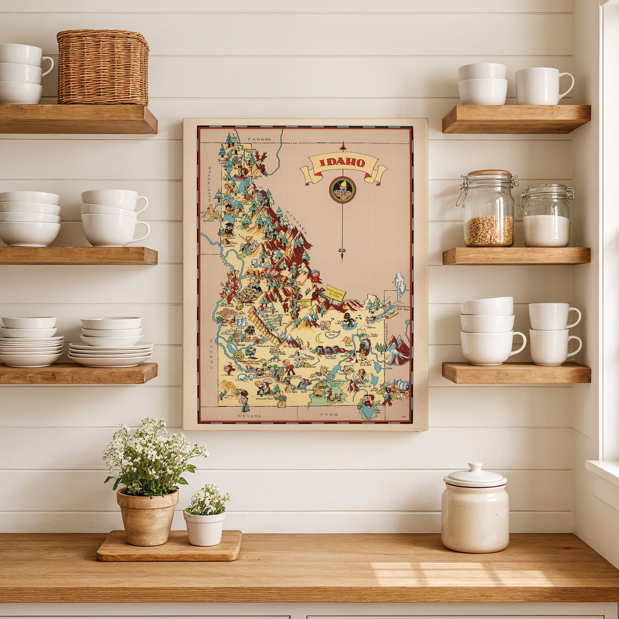
Discover the vibrant Idaho Map from 1935, capturing Idaho as a land defined by mountains, rivers, and frontier memory—vast, rugged, and still shaped by the stories of prospectors, homesteaders, and Native nations. This lively pictorial map preserves the state at a moment when its identity blended Western folklore with emerging modern pride. Rather than strict geography, the artist offers a spirited panorama where history, legend, and landscape coexist in colorful harmony.
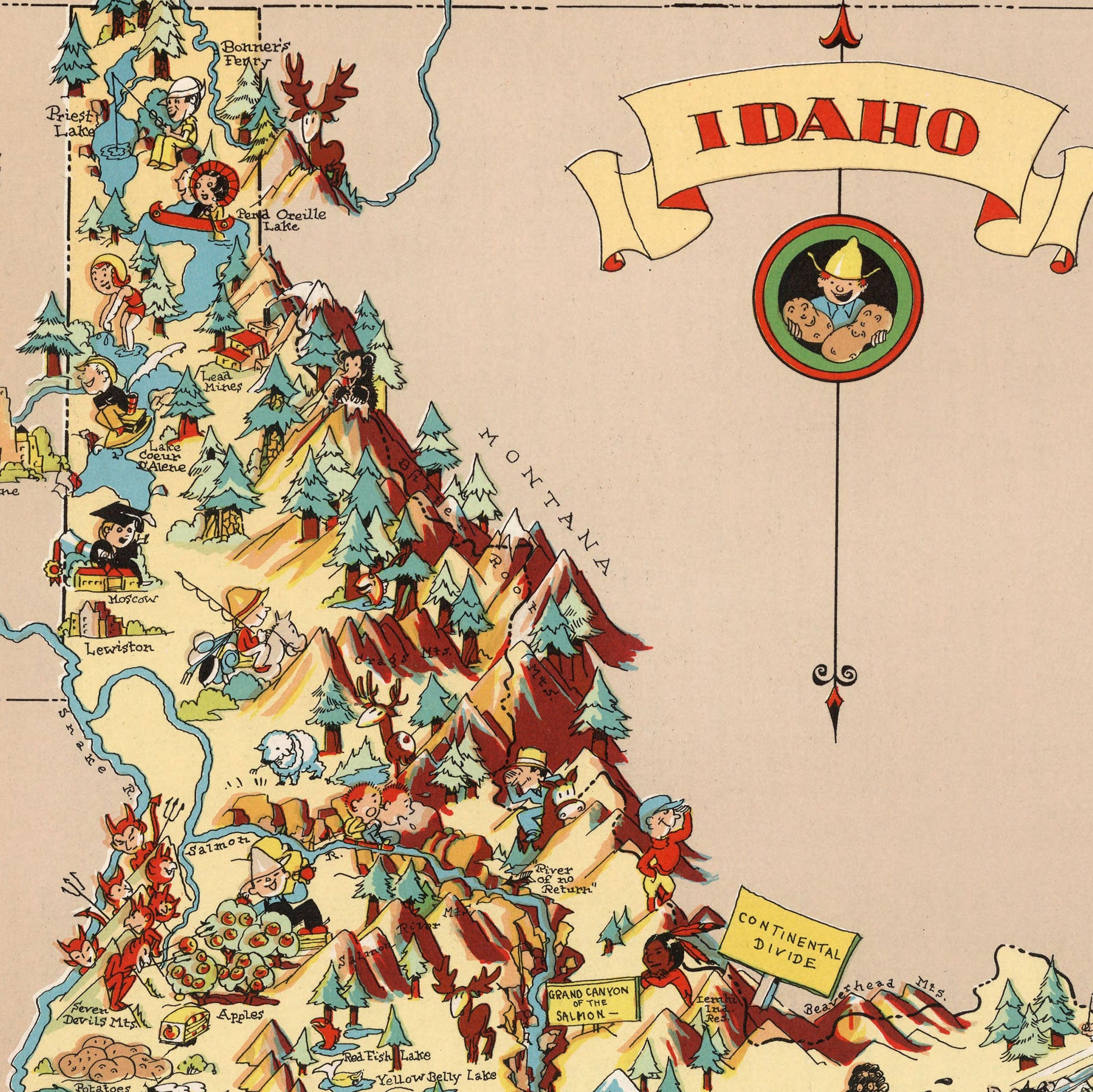
From the towering Bitterroot Range to the deep canyons of the Snake River, this Idaho Map presents Idaho as a place carved by natural drama. Forests teem with wildlife, from elk and bears to trout-filled lakes that draw anglers from every direction. Logging camps, lookout towers, and miners with pickaxes scatter across the northern mountains, reflecting the industries that anchored early Idaho life and built communities throughout the rugged terrain.
Moving south, the Idaho Map shows the fertile plains of the Snake River Valley unfolding in softer tones. Ranchers, sheep herders, and farmers appear throughout the landscape, embodying the agricultural transformation that defined the region in the early 20th century. From potatoes to sugar beets, these rich fields supported growing communities such as Twin Falls, Idaho Falls, and Pocatello, establishing Idaho's reputation as a vital agricultural state.
Idaho's history is beautifully told through whimsical scenes placed across this Idaho Map: pioneers crossing rugged trails, fur trappers paddling canoes, stagecoaches racing along dusty routes, and Indigenous peoples whose presence predates every settlement. Even natural wonders such as Craters of the Moon, Shoshone Falls, and Hells Canyon appear as small but striking reminders of the state's wild geological story. The Continental Divide is marked dramatically in the southeast, where travelers and explorers moved between ranges toward Yellowstone and beyond.
Perfect for Idaho residents, Western history enthusiasts, and collectors of vintage state maps, this Idaho Map reproduction includes a custom historical certificate. By the 1930s, Idaho was stepping confidently into the modern era while celebrating the frontier spirit that defined it. Printed on heavyweight archival paper or hand-stretched polycotton canvas, every mountain range, historical vignette, and illustrated detail is restored in museum-grade clarity for generations of enjoyment. Paper prints ship rolled in heavy-duty tubes, while canvas editions arrive gallery-wrapped on solid pine stretcher bars with pre-installed hardware—ready to display the moment it arrives. Bring home a piece of Idaho heritage and celebrate a state where mountains, stories, and people together shaped a distinctly Western identity.
The Map Story
From the towering Bitterroot Range to the deep canyons of the Snake River, the map presents Idaho as a place carved by natural drama. Forests teem with wildlife, from elk and bears to trout-filled lakes that draw anglers from every direction. Logging camps, lookout towers, and miners with pickaxes scatter across the northern mountains, reflecting the industries that anchored early Idaho life.
Moving south, the fertile plains of the Snake River Valley unfold in softer tones. Ranchers, sheep herders, and farmers appear throughout the landscape, embodying the agricultural transformation that defined the region in the early 20th century. From potatoes to sugar beets, these rich fields supported growing communities such as Twin Falls, Idaho Falls, and Pocatello.
Idaho's history is told through whimsical scenes placed across the state: pioneers crossing rugged trails, fur trappers paddling canoes, stagecoaches racing along dusty routes, and Indigenous peoples whose presence predates every settlement. Even natural wonders such as Craters of the Moon, Shoshone Falls, and Hells Canyon appear as small but striking reminders of the state's wild geological story.
In the southeast, the Continental Divide is marked dramatically, where travelers and explorers moved between ranges toward Yellowstone and beyond. The map's edges playfully connect Idaho to neighboring states, showing wagons, cowboys, and mountain trails that placed Idaho within the broader story of the American West.
By the 1930s, Idaho was stepping confidently into the modern era while celebrating the frontier spirit that defined it. Rich in color and character, the map invites the viewer to wander Idaho through imagination, capturing a state where mountains, stories, and people together shaped a distinctly Western identity.
Materials
Choose options

Because every place has a story
Make History Personal
A vintage map is more than art.
It is a reminder of where life began.
Where memories were made.
Where hearts still live. Give the gift of place.
Beautifully preserved and made for the moments that matter.
Why Choose Us?
| Feature | Us | Competitor A | Competitor B |
|---|---|---|---|
| Hand Crafted | |||
| Museum Quality | |||
| 100 Year Guarantee | |||
| Restored by Hand | |||
| Certificate of Authenticity |

Art Prints
Archival quality colors. Best option if you'd like to frame it yourself

The Best Materials
We hand-stretched our canvas on solid American-grown pine stretcher bars. We use quality canvas and fade-resistant inks to create the lasting art. Canvases come with hardware already installed and ready to hang.
Need help?
Frequently Asked Questions
Order
All of our maps are meticulously restored reproductions of historic originals. Each piece is digitally repaired and color-corrected to bring out the finest details while preserving its authentic, vintage character.
Yes. All Archive Prints products are printed to order in the USA with archival materials.
We offer two premium formats:
- High-Quality Paper Posters – Printed on thick, archival-grade matte paper for rich, vibrant detail.
- Hand-Stretched Canvas Prints – Printed on premium polycotton canvas and mounted on 1.5" solid American pine stretcher bars for a gallery-quality finish.
We carefully digitally restore each map to enhance clarity and color while preserving its original look and historic charm. You’ll enjoy sharp details and a timeless vintage aesthetic that feels true to the original piece.
Yes, we do! We offer premium framing options to make your map ready to hang the moment it arrives. You can choose from Oak, Maple, Black, or Walnut frames directly on the product page. We also offer Stretched Canvas prints for a modern gallery look, as well as archival-quality Posters if you prefer to frame it yourself.
Yes! We offer free shipping on all products within the United States. Each map is carefully packaged to ensure it arrives in perfect condition.
If you’re not completely satisfied, you can return your order in new condition for a full refund. Return shipping costs are the responsibility of the customer.
Absolutely! Our maps make thoughtful, one-of-a-kind gifts for history lovers, map collectors, or anyone looking to add vintage character to their home or office. Choose between paper prints for framing or stretched canvas for a ready-to-hang presentation.
- Paper Posters → Shipped in durable, protective tubes to prevent creasing.
- Canvas Prints → Carefully wrapped, padded, and boxed to ensure safe delivery.
Our maps look stunning in a variety of settings, including:
- Living rooms and home offices
- Libraries and studies
- Corporate offices and conference rooms
- Restaurants, cafes, and boutique spaces