
Kendall County Vintage Map - 1879 Texas General Land Office Map
Discover Kendall County's Pioneer Heritage
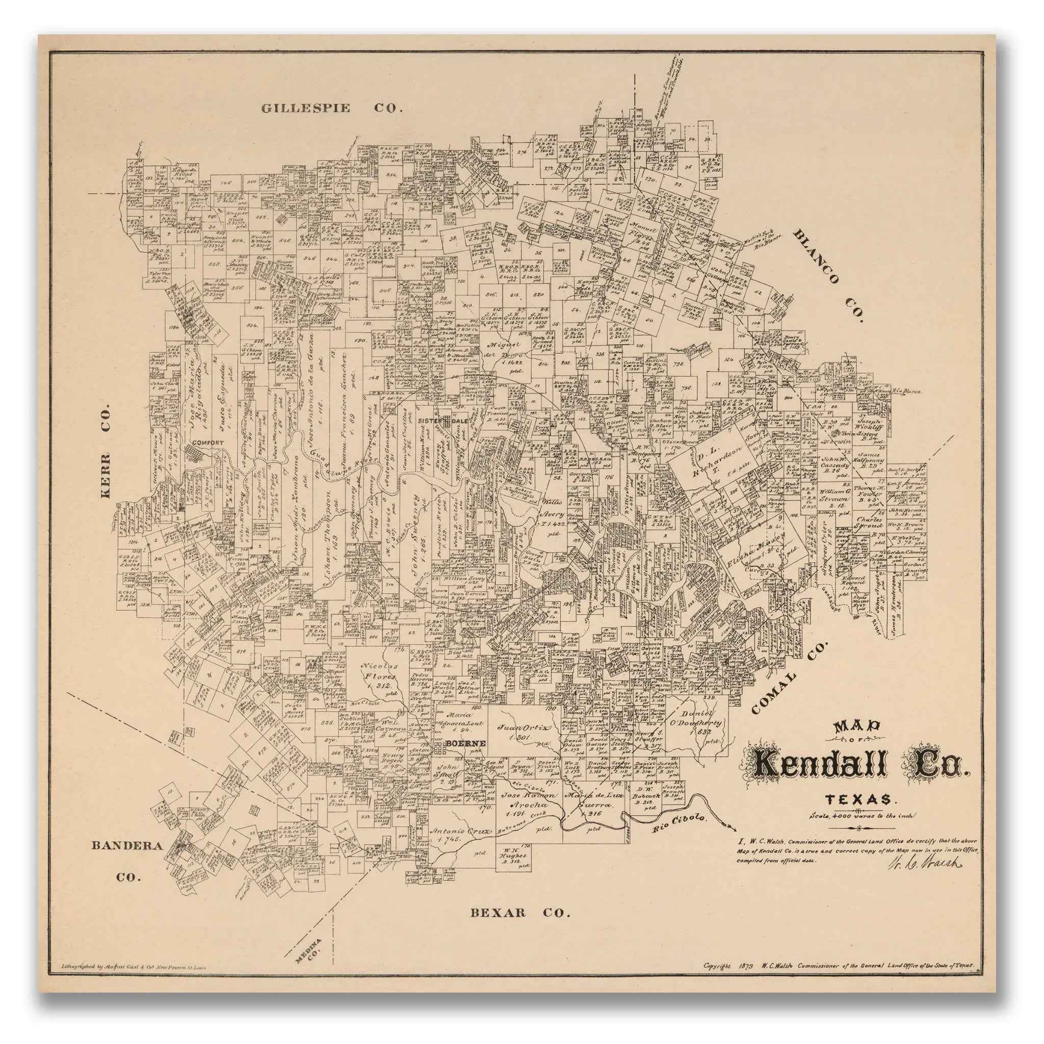
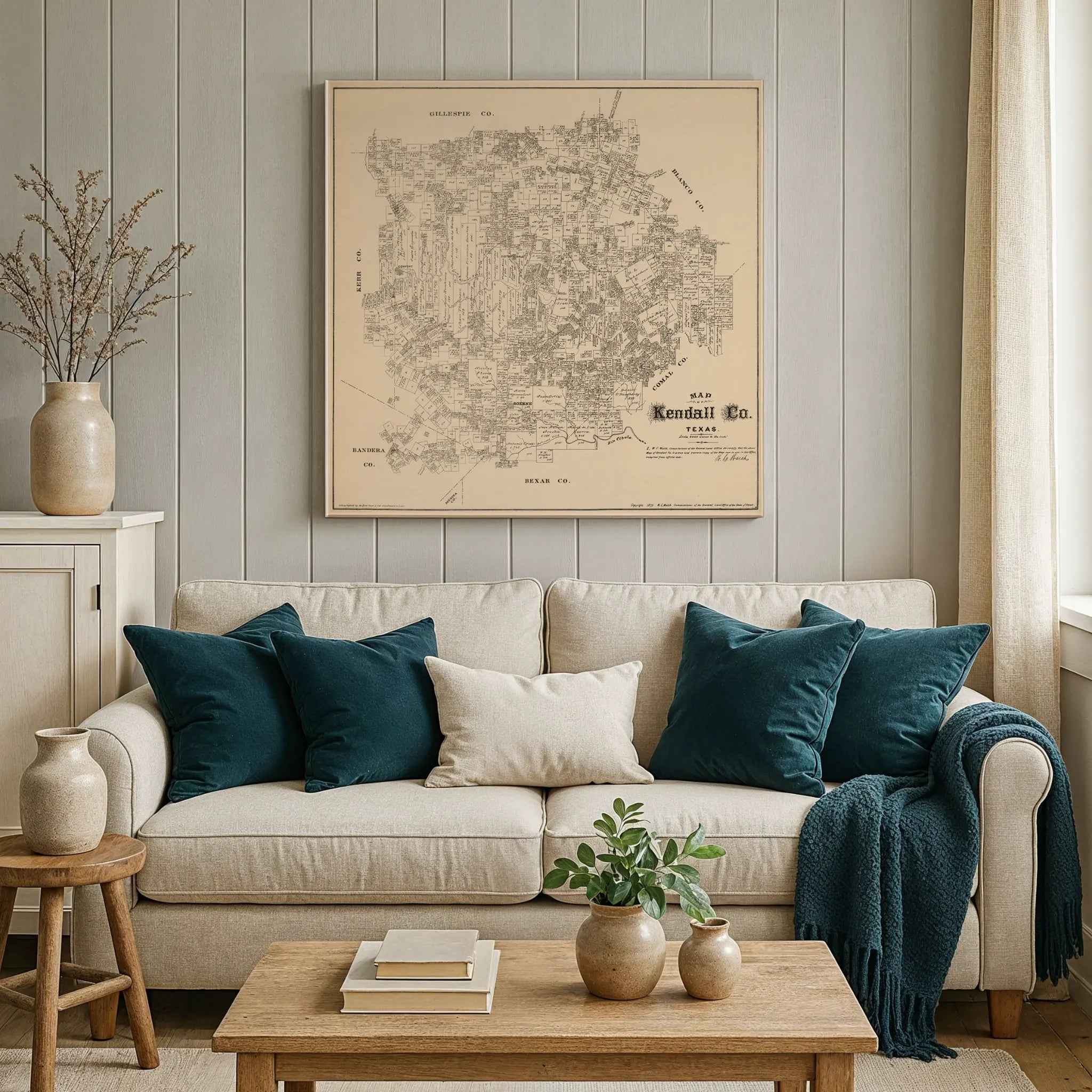
Step into the remarkable world of 1879 Kendall County with this meticulously detailed General Land Office map that captures the Texas Hill Country during its formative years of German settlement and frontier development. This extraordinary cartographic document by W.C. Walsh, Commissioner of the General Land Office of Texas, reveals Kendall County as a mosaic of individual land grants, family homesteads, and emerging communities that would define the character of this unique region in the heart of Texas.
Historical Significance
In 1879, Kendall County stood as a testament to the successful German immigration to Texas that began in the 1840s. This official General Land Office map documents the county during a crucial period when German settlers, drawn by the promise of fertile land and religious freedom, had established thriving communities throughout the Hill Country. The map showcases the systematic division of land into individual parcels, each bearing the names of the pioneering families who carved homesteads from the rugged terrain and built the foundations of what would become one of Texas's most distinctive cultural regions.
Cartographic Excellence
This masterful survey map showcases the meticulous precision of 19th-century Texas land documentation. Every section, survey line, and property boundary is carefully delineated, creating a comprehensive record of land ownership that served both legal and practical purposes. The map reveals the complex patchwork of land grants, from large ranch holdings to smaller family farms, showing how the county was systematically settled and developed. Neighboring counties—Gillespie, Blanco, Comal, and Bandera—are clearly marked, providing geographical context for this Hill Country gem.
Settlement Story
Within the detailed survey lines, the story of German-Texan settlement unfolds through individual landowner names that reflect the county's unique cultural heritage. The map captures the essence of a community built by families who brought Old World traditions to the Texas frontier, establishing farms, ranches, and small towns that balanced European customs with American frontier pragmatism. Each named parcel represents a family's dream of prosperity in the New World, creating a tapestry of settlement that made Kendall County a distinctive blend of German efficiency and Texas independence.
Hill Country Heritage
Beyond its function as a legal document, this map represents the vision and determination of the German immigrants who transformed the Texas Hill Country into a thriving agricultural region. The careful documentation of creeks, hills, and natural features reveals how settlers adapted their farming techniques to the unique topography of Central Texas. The presence of communities like Boerne, the county seat established by German colonists, hints at the cultural institutions—churches, schools, and social organizations—that would preserve German traditions while embracing American opportunities.
This detailed cartographic record preserves Kendall County at a pivotal moment in its development—when the pioneer generation was establishing the institutions and traditions that would define the region for generations to come. The map captures the essence of a community that valued both individual enterprise and collective cooperation, creating a unique German-Texan culture that remains vibrant today. Perfect for collectors of Texas history, German-American heritage enthusiasts, and those with connections to the Hill Country, this restored map serves as both a genealogical treasure and a stunning piece of wall art that celebrates the vision and perseverance that built one of Texas's most charming regions.
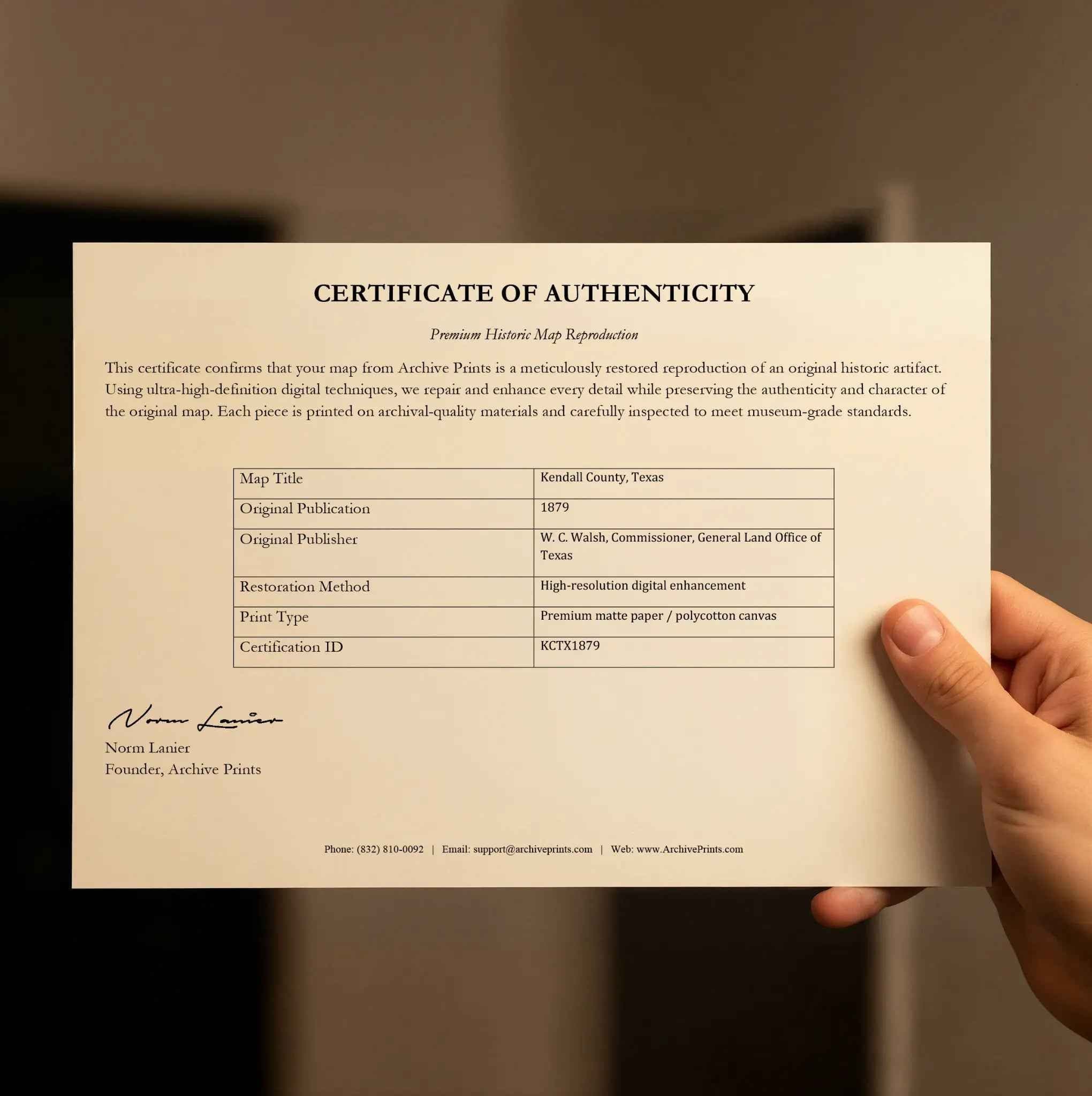
Each reproduction includes a custom historical letter detailing Kendall County's role in German immigration to Texas and the unique cultural heritage that made the Hill Country a distinctive part of the Lone Star State. Printed on heavyweight archival paper or premium canvas, every property line, landowner name, and geographical feature is preserved with museum-quality clarity through expert digital restoration.
For protection and presentation, paper prints arrive rolled in sturdy mailing tubes, while canvas prints come gallery-wrapped on solid pine stretcher bars with pre-installed hanging hardware—ready to display immediately.
Bring home a piece of Texas Hill Country history with this captivating glimpse into Kendall County's German-Texan heritage and pioneering spirit.
The Map Story
This 1879 map of Kendall County was compiled under the direction of W. C. Walsh, Commissioner of the Texas General Land Office. It portrays a Hill Country county still young, having been created only in 1862, yet already firmly shaped by German immigration, frontier ranching, and the rugged terrain of the Edwards Plateau. By 1879 Kendall County was beginning to define its character as a community of farms, ranches, and small towns connected by winding roads and river valleys.
The map shows Kendall County divided into numerous land grants, many dating back to the Republic of Texas. Family names of settlers and surveyors mark the parcels, reflecting how land distribution spurred migration into the Hill Country. Boerne, the county seat, appears prominently along Cibolo Creek. Founded in 1852 by German immigrants, Boerne had grown into a cultural and commercial center by the late 1870s, complete with churches, schools, and businesses tied to both local ranching and trade with San Antonio.
Other settlements such as Comfort are also depicted. Established in 1854, Comfort became notable for its freethinking German community and its role in Texas history during the Civil War era. Smaller ranching and farming communities appear across the map, underscoring the dispersed population of the county.
Natural features are central to Kendall’s geography. The Guadalupe River winds through the county, joined by creeks and springs that provided water for settlers and livestock. The rolling hills and limestone outcrops of the Hill Country made farming difficult in some areas but offered excellent grazing land. This terrain also contributed to the county’s scenic beauty, which even in the nineteenth century began to attract visitors seeking clean air and natural surroundings.
Transportation in 1879 relied on wagon roads connecting Boerne and Comfort to San Antonio, Fredericksburg, and neighboring counties. The arrival of railroads was still years away, so trade depended on overland routes for cattle, crops, and goods. Nevertheless, Kendall’s proximity to San Antonio gave its communities access to markets and resources that helped sustain growth.
Materials
Hand‑Stretched Canvas: If you choose canvas, we use a premium cotton‑poly blend stretched over solid pine frames. Each canvas is carefully hand‑stretched for a tight, gallery‑quality finish that's ready to hang right out of the box.
Vivid, Fade‑Resistant Inks: We use professional‑grade inks that are UV‑resistant, so your print retains its rich colors even when displayed in bright rooms.
Expert Restoration: Every map is digitally restored by skilled artisans. We preserve the character of the original while enhancing clarity, so you see the map as it was meant to be seen.
Secure Packaging: Paper prints are rolled in heavy‑duty mailing tubes, and canvases are cushioned in reinforced boxes to ensure they arrive in pristine condition.
Choosing one of our prints means investing in craftsmanship. We combine historical authenticity with modern print technology and premium materials, giving you a work of art built to stand the test of time.
Choose options

Because every place has a story
Make History Personal
A vintage map is more than art.
It is a reminder of where life began.
Where memories were made.
Where hearts still live. Give the gift of place.
Beautifully preserved and made for the moments that matter.
Why Choose Us?
| Feature | Us | Competitor A | Competitor B |
|---|---|---|---|
| Hand Crafted | |||
| Museum Quality | |||
| 100 Year Guarantee | |||
| Restored by Hand | |||
| Certificate of Authenticity |

Art Prints
Archival quality colors. Best option if you'd like to frame it yourself

The Best Materials
We hand-stretched our canvas on solid American-grown pine stretcher bars. We use quality canvas and fade-resistant inks to create the lasting art. Canvases come with hardware already installed and ready to hang.
Need help?
Frequently Asked Questions
Order
All of our maps are meticulously restored reproductions of historic originals. Each piece is digitally repaired and color-corrected to bring out the finest details while preserving its authentic, vintage character.
Yes. All Archive Prints products are printed to order in the USA with archival materials.
We offer two premium formats:
- High-Quality Paper Posters – Printed on thick, archival-grade matte paper for rich, vibrant detail.
- Hand-Stretched Canvas Prints – Printed on premium polycotton canvas and mounted on 1.5" solid American pine stretcher bars for a gallery-quality finish.
We carefully digitally restore each map to enhance clarity and color while preserving its original look and historic charm. You’ll enjoy sharp details and a timeless vintage aesthetic that feels true to the original piece.
Yes, we do! We offer premium framing options to make your map ready to hang the moment it arrives. You can choose from Oak, Maple, Black, or Walnut frames directly on the product page. We also offer Stretched Canvas prints for a modern gallery look, as well as archival-quality Posters if you prefer to frame it yourself.
Yes! We offer free shipping on all products within the United States. Each map is carefully packaged to ensure it arrives in perfect condition.
If you’re not completely satisfied, you can return your order in new condition for a full refund. Return shipping costs are the responsibility of the customer.
Absolutely! Our maps make thoughtful, one-of-a-kind gifts for history lovers, map collectors, or anyone looking to add vintage character to their home or office. Choose between paper prints for framing or stretched canvas for a ready-to-hang presentation.
- Paper Posters → Shipped in durable, protective tubes to prevent creasing.
- Canvas Prints → Carefully wrapped, padded, and boxed to ensure safe delivery.
Our maps look stunning in a variety of settings, including:
- Living rooms and home offices
- Libraries and studies
- Corporate offices and conference rooms
- Restaurants, cafes, and boutique spaces