Kentucky Map - Vintage State Map by H.S. Tanner for Collectors
Discover a Piece of Kentucky History
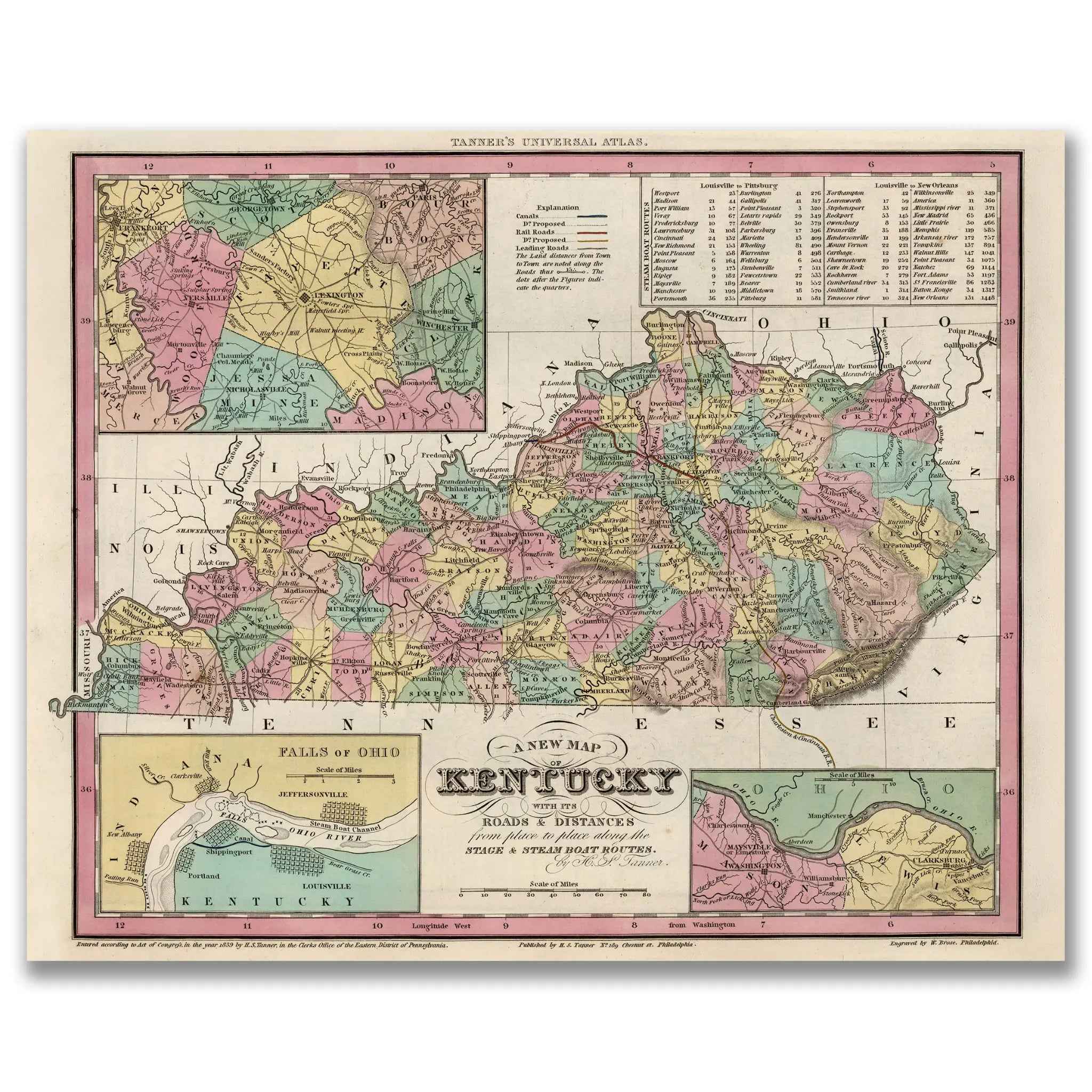
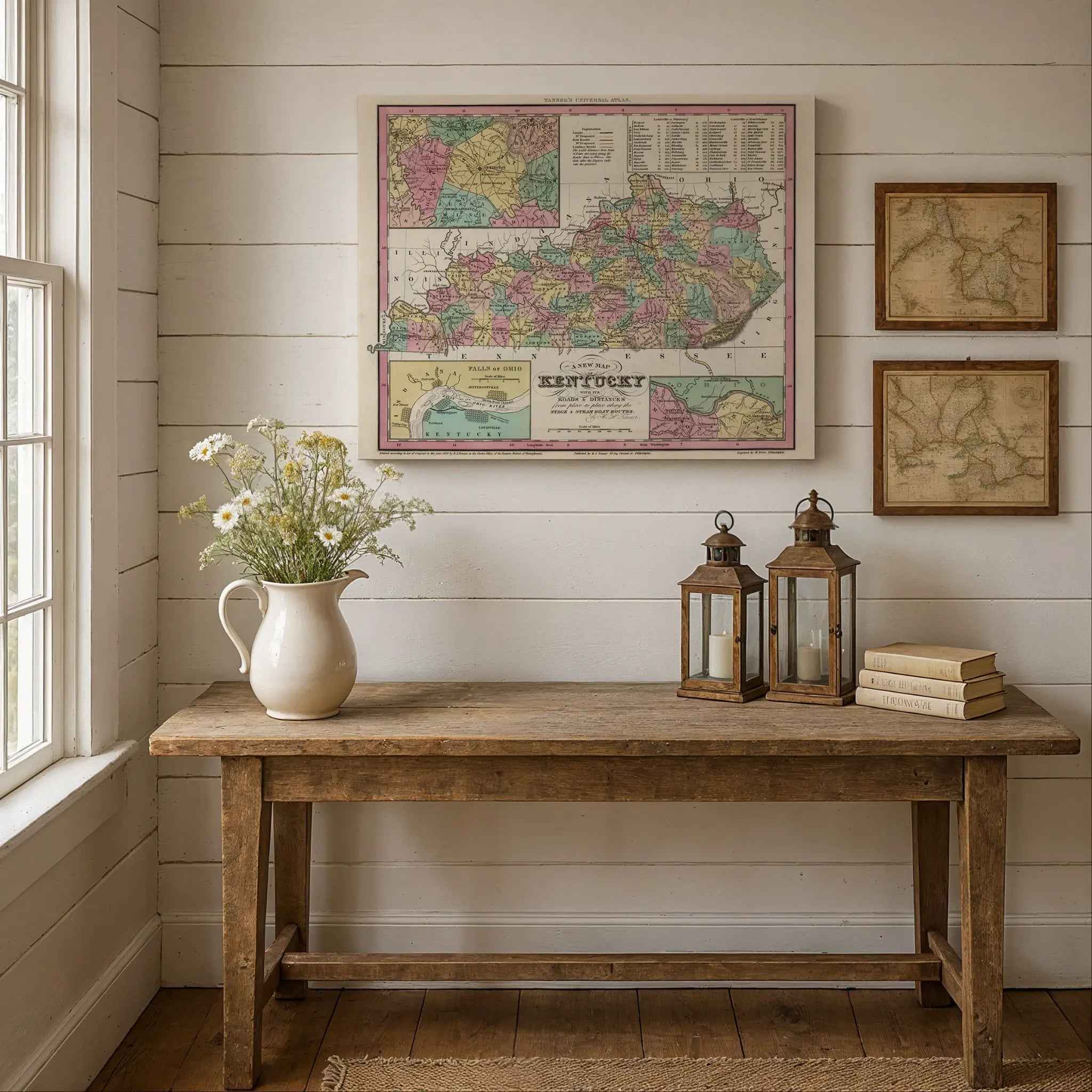
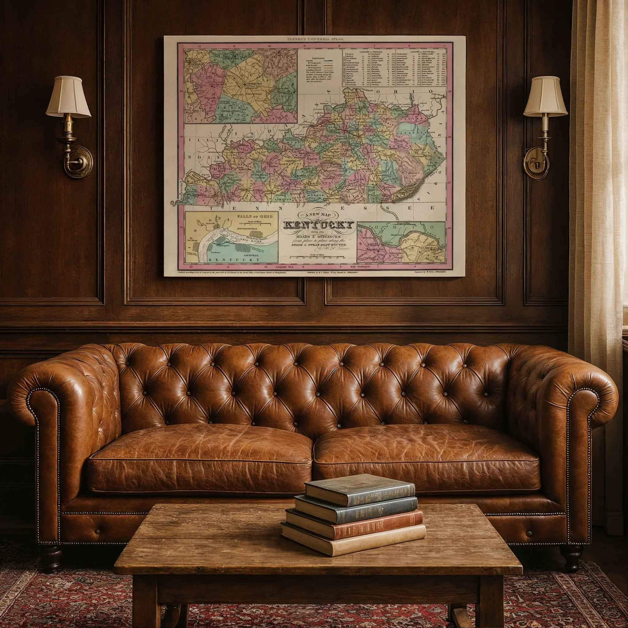
Step back into the 1830s and explore the burgeoning American frontier with this beautifully restored 1839 Kentucky Map. Created by the renowned cartographer H.S. Tanner, this map is more than a geographical record; it’s a vivid portrait of a state at a pivotal moment in the nineteenth century. Framed by an elegant decorative border and featuring detailed insets of key areas like the Falls of Ohio, it meticulously charts Kentucky’s roads and distances, highlighting vital stage and steamboat routes that connected its growing towns and communities.
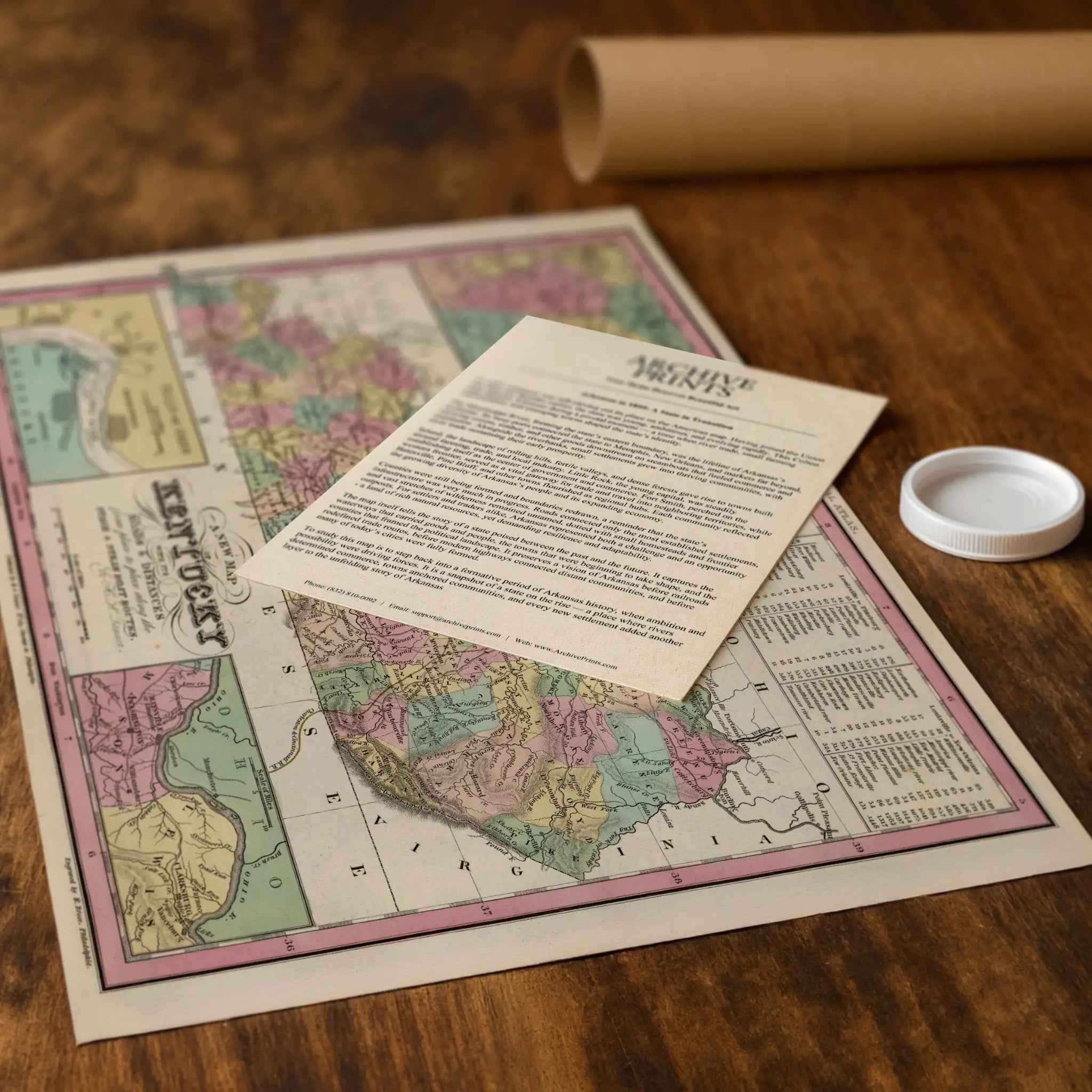
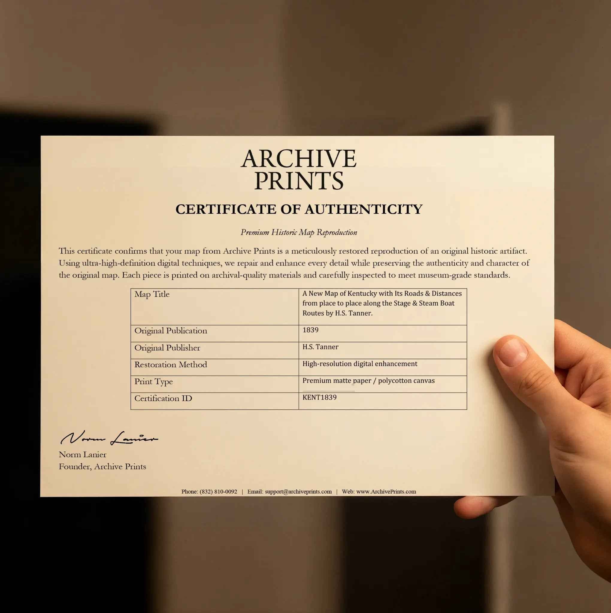
Each reproduction includes a custom historical letter that tells the story behind the map, making it an ideal gift for collectors, cartography fans, and anyone who loves American history. Printed on heavyweight archival paper or premium poly-cotton canvas, every label, county line, and river is preserved in ultra-high-definition clarity thanks to meticulous digital restoration—rich ink tones, crisp linework, and the warm vintage patina intact.
For protection and presentation, we craft every detail with care. Paper prints are rolled in a sturdy cardboard mailing tube and sized for easy framing. Canvas prints are gallery-wrapped on solid 1.5″ pine stretcher bars and ship in reinforced boxes—ready to hang with a pre-installed sawtooth hanger.
Bring home more than wall art. Bring home a story, a conversation piece, and a striking centerpiece that celebrates Kentucky’s rich heritage, its role as a gateway to the West, and the timeless spirit of its people.
The Map Story
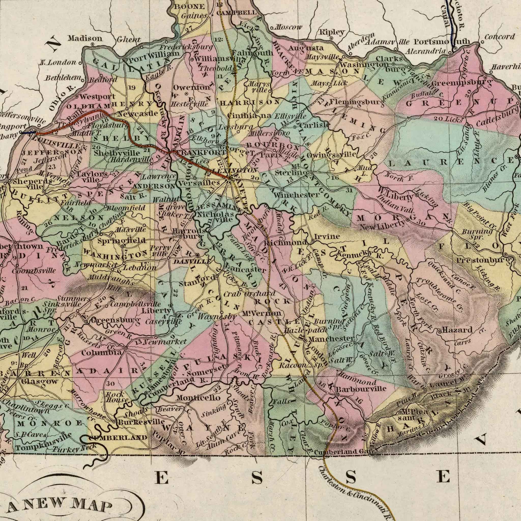
Tanner’s 1839 map of Kentucky doesn’t just chart counties and borders—it sketches a living landscape in the middle of transformation. Pastel blocks of counties spread like quilt squares, stitched together by rivers and stage roads. Insets of Lexington and the Falls of Ohio pull the viewer closer, reminding us where the state’s pulse beat loudest.
It is 1839, and Martin Van Buren holds the presidency. The nation is restless, shaken by economic downturn and sharpening debates over slavery, banks, and westward expansion. In Kentucky, those arguments echo in taverns and courthouses, but so do the clatter of wagons, the splash of riverboats, and the voices of traders. This is the soil of Henry Clay’s compromise politics, yet also a land where farmers and merchants chase profit along riverbanks and turnpikes.
Louisville rises as a commercial gateway, its wharves stacked with hogsheads of tobacco and barrels of bourbon bound downstream. Steamboats churn the Ohio into froth, carrying Kentucky’s goods to Cincinnati, New Orleans, and beyond. Lexington, heart of the bluegrass, builds its reputation not only on hemp and fine farms but on horseflesh—the colts and mares that would earn the region lasting fame. Tanner’s sheet shows neat lines of roads, but in reality those roads were dusty tracks where stagecoaches rattled, carrying mail, passengers, and gossip across rolling hills.
Kentucky’s dual identity runs through every mile. On one side, fertile farms of hemp, corn, and wheat feed a booming river trade; on the other, a frontier spirit lingers in cabins at the edge of clearings, where hunters still move with rifle and hound. Tobacco warehouses stand near blacksmith shops, while general stores sell both plowshares and calico. The state is both polished and rough, rooted in soil yet pulled outward by the tide of commerce.
Politics hum in the background. Clay’s voice still thunders from Lexington, even as the state grapples with its place between North and South. Debates over slavery hang in the air, not just in legislative halls but in everyday lives. Kentucky is a borderland—part marketplace, part battleground of ideas.
Look at the map from afar and you see symmetry—counties neatly arranged, rivers winding with grace. Step closer and you sense motion: the whistle of a steamboat, the whinny of a thoroughbred, the creak of a stagecoach, the murmur of a marketplace. Tanner’s Kentucky is not frozen in lines; it is alive with the rhythm of a people balancing heritage and ambition, perched between old frontier grit and the polished confidence of a maturing state.
Materials
Hand‑Stretched Canvas: If you choose canvas, we use a premium cotton‑poly blend stretched over solid pine frames. Each canvas is carefully hand‑stretched for a tight, gallery‑quality finish that’s ready to hang right out of the box.
Vivid, Fade‑Resistant Inks: We use professional‑grade inks that are UV‑resistant, so your print retains its rich colors even when displayed in bright rooms.
Expert Restoration: Every map is digitally restored by skilled artisans. We preserve the character of the original while enhancing clarity, so you see the map as it was meant to be seen.
Secure Packaging: Paper prints are rolled in heavy‑duty mailing tubes, and canvases are cushioned in reinforced boxes to ensure they arrive in pristine condition.
Choosing one of our prints means investing in craftsmanship. We combine historical authenticity with modern print technology and premium materials, giving you a work of art built to stand the test of time.
Choose options

Because every place has a story
Make History Personal
A vintage map is more than art.
It is a reminder of where life began.
Where memories were made.
Where hearts still live. Give the gift of place.
Beautifully preserved and made for the moments that matter.
Why Choose Us?
| Feature | Us | Competitor A | Competitor B |
|---|---|---|---|
| Hand Crafted | |||
| Museum Quality | |||
| 100 Year Guarantee | |||
| Restored by Hand | |||
| Certificate of Authenticity |

Art Prints
Archival quality colors. Best option if you'd like to frame it yourself

The Best Materials
We hand-stretched our canvas on solid American-grown pine stretcher bars. We use quality canvas and fade-resistant inks to create the lasting art. Canvases come with hardware already installed and ready to hang.
Need help?
Frequently Asked Questions
Order
All of our maps are meticulously restored reproductions of historic originals. Each piece is digitally repaired and color-corrected to bring out the finest details while preserving its authentic, vintage character.
Yes. All Archive Prints products are printed to order in the USA with archival materials.
We offer two premium formats:
- High-Quality Paper Posters – Printed on thick, archival-grade matte paper for rich, vibrant detail.
- Hand-Stretched Canvas Prints – Printed on premium polycotton canvas and mounted on 1.5" solid American pine stretcher bars for a gallery-quality finish.
We carefully digitally restore each map to enhance clarity and color while preserving its original look and historic charm. You’ll enjoy sharp details and a timeless vintage aesthetic that feels true to the original piece.
Yes, we do! We offer premium framing options to make your map ready to hang the moment it arrives. You can choose from Oak, Maple, Black, or Walnut frames directly on the product page. We also offer Stretched Canvas prints for a modern gallery look, as well as archival-quality Posters if you prefer to frame it yourself.
Yes! We offer free shipping on all products within the United States. Each map is carefully packaged to ensure it arrives in perfect condition.
If you’re not completely satisfied, you can return your order in new condition for a full refund. Return shipping costs are the responsibility of the customer.
Absolutely! Our maps make thoughtful, one-of-a-kind gifts for history lovers, map collectors, or anyone looking to add vintage character to their home or office. Choose between paper prints for framing or stretched canvas for a ready-to-hang presentation.
- Paper Posters → Shipped in durable, protective tubes to prevent creasing.
- Canvas Prints → Carefully wrapped, padded, and boxed to ensure safe delivery.
Our maps look stunning in a variety of settings, including:
- Living rooms and home offices
- Libraries and studies
- Corporate offices and conference rooms
- Restaurants, cafes, and boutique spaces