
Little Rock & Argenta, Arkansas Map 1888
Little Rock & Argenta, Arkansas Map 1888
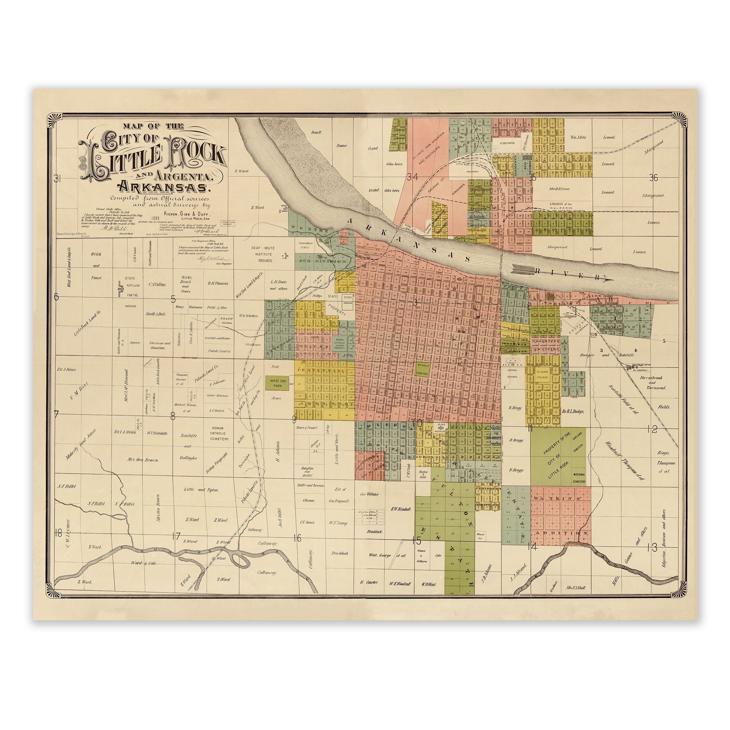
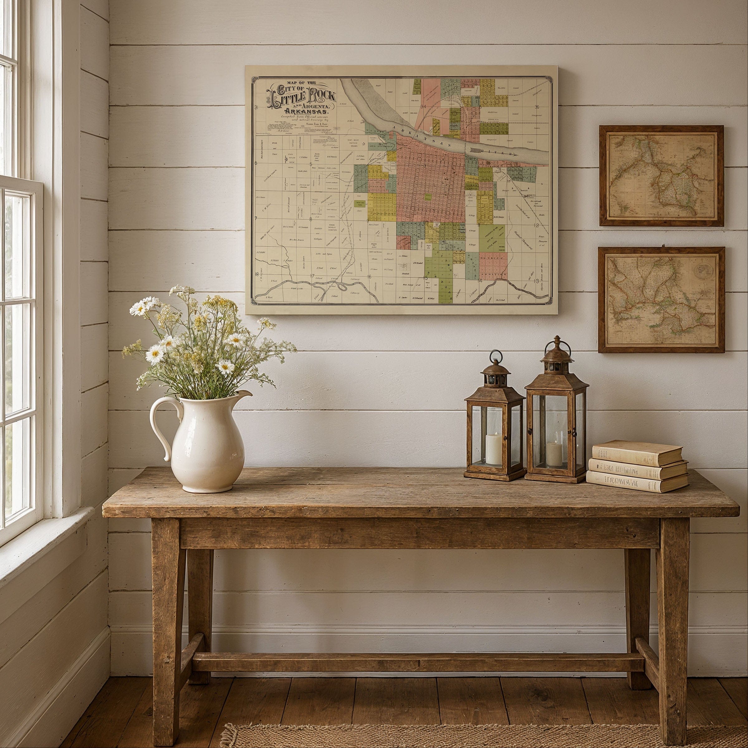
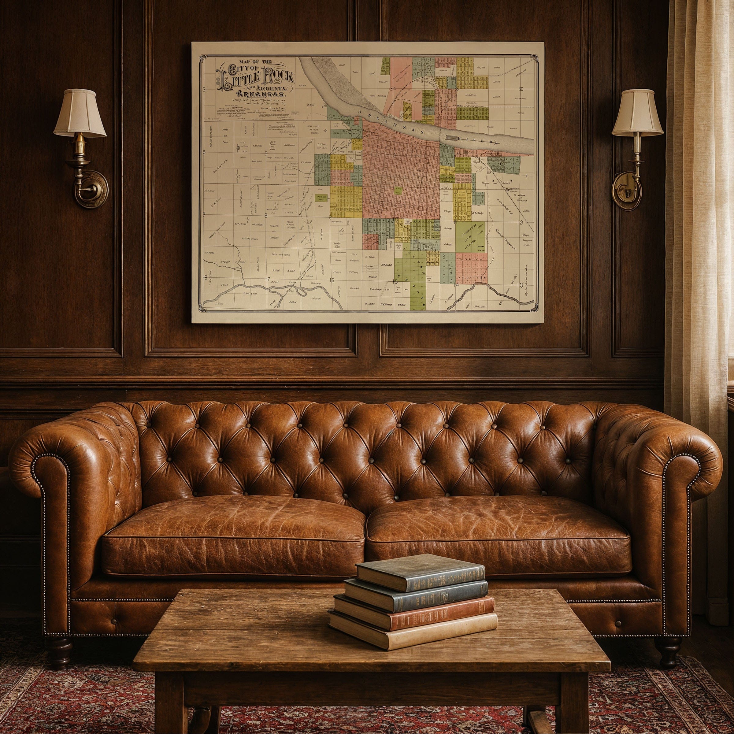
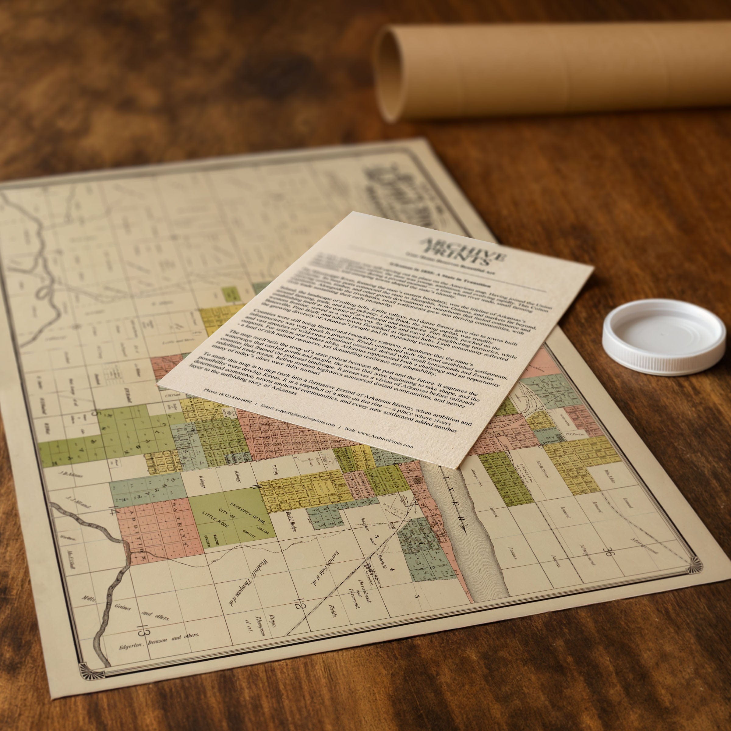
Discover the detailed Little Rock & Argenta, Arkansas Map from 1888, capturing Little Rock as a city expanding in every direction. Compiled from official surveys by Rees, Gibb & Darr, this precise plat map presents a young capital city laying the groundwork for its modern identity—its neighborhoods, institutions, and transportation routes carefully measured and recorded as the city prepared for rapid growth along the Arkansas River.
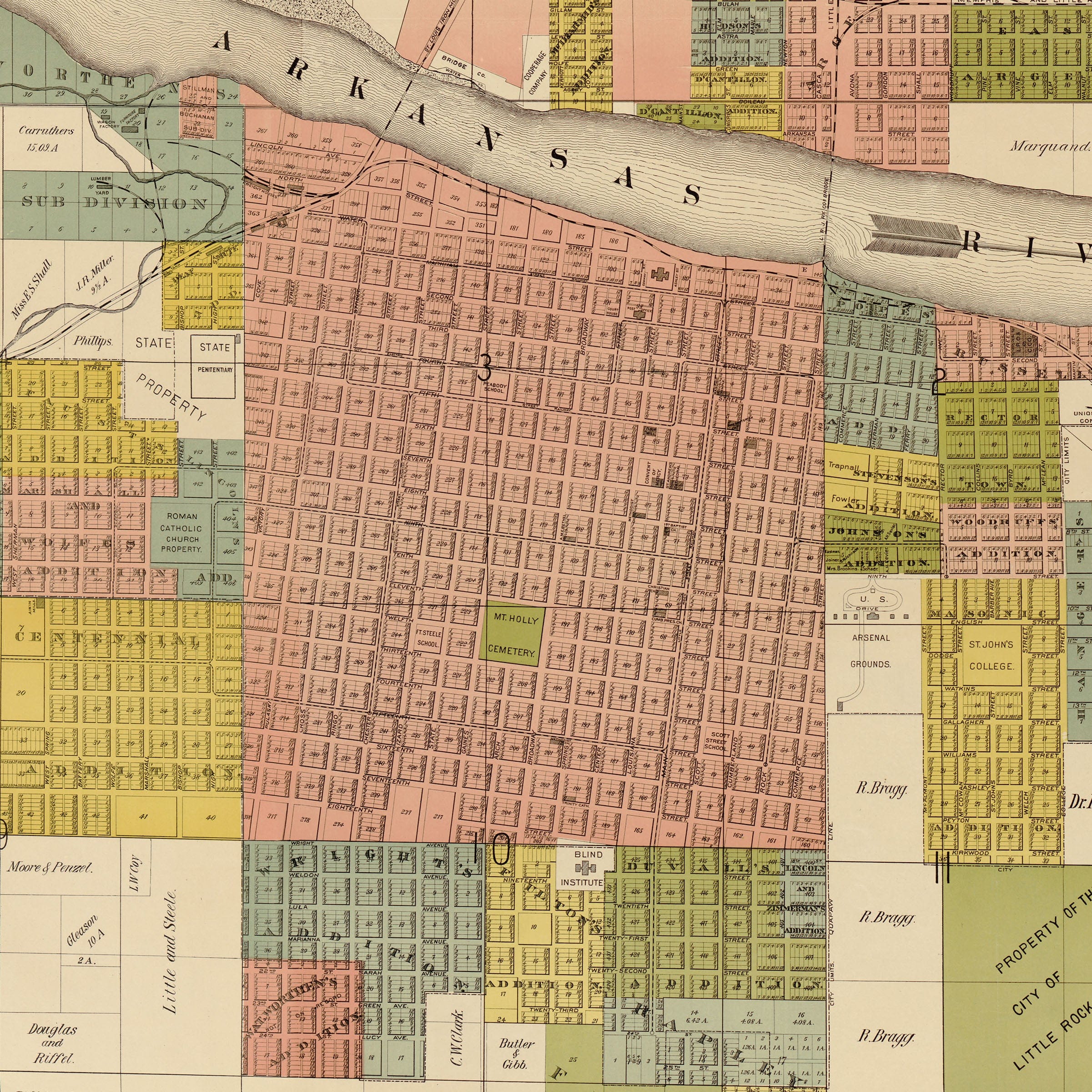
Unlike the dramatic bird's-eye panoramas of the era, this Little Rock & Argenta, Arkansas Map offers a grounded, engineer's view of the city. Streets appear as clean lines stretching outward from the riverfront, forming the familiar grid that shaped Little Rock's development. Blocks are divided into lots, many already labeled with the names of early landowners, churches, institutions, and local businesses. Even vacant parcels tell a story—of land waiting for homes, factories, and public buildings that would soon rise as the city expanded into one of the South's important capitals.
At the top of this Little Rock & Argenta, Arkansas Map, the Arkansas River sweeps east to west, its broad channel separating Little Rock from Argenta—today's North Little Rock. Ferries and early bridges are noted along the shoreline, marking key crossings that linked the two communities long before the grand spans of the 20th century. Both sides of the river show signs of steady growth, with Argenta beginning to develop its own identity as an industrial and railroad-centered settlement that would complement Little Rock's role as state capital.
Within the city limits shown on this Little Rock & Argenta, Arkansas Map, prominent institutions appear across the grid. The State Asylum, Deaf-Mute Institute, public parks, cemeteries, schools, and early railroad depots all take their place in the developing urban landscape. These landmarks reflect a capital investing in infrastructure, civic life, and public welfare. Neighborhoods stretch outward from the old core near Markham and Main, where commercial blocks and government buildings anchored the city. The map captures early additions and subdivisions—each marking new chapters in Little Rock's expansion.
Perfect for Little Rock residents, Arkansas history enthusiasts, and collectors of Southern urban cartography, this Little Rock & Argenta, Arkansas Map reproduction includes a custom historical certificate. The 1888 map preserves the city at a moment when planning and possibility converged—every block, tract, and survey line represents Little Rock's ambitions as a rising Southern capital. Printed on heavyweight archival paper or hand-stretched polycotton canvas, every street, lot line, and landmark is restored in museum-grade clarity for generations of enjoyment. Paper prints ship rolled in heavy-duty tubes, while canvas editions arrive gallery-wrapped on solid pine stretcher bars with pre-installed hardware—ready to display the moment it arrives. Bring home a piece of Little Rock history and celebrate a city in the process of becoming.
The Map Story
Unlike the dramatic bird's-eye panoramas of the era, this map offers a grounded, engineer's view of the city. Streets appear as clean lines stretching outward from the riverfront, forming the familiar grid that shaped Little Rock's development. Blocks are divided into lots, many already labeled with the names of early landowners, churches, institutions, and local businesses. Even vacant parcels tell a story—of land waiting for homes, factories, and public buildings that would soon rise as the city expanded.
At the top of the map, the Arkansas River sweeps east to west, its broad channel separating Little Rock from Argenta—today's North Little Rock. Ferries and early bridges are noted along the shoreline, marking key crossings that linked the two communities long before the grand spans of the 20th century. Both sides of the river show signs of steady growth, with Argenta beginning to develop its own identity as an industrial and railroad-centered settlement.
Within the city limits, prominent institutions appear across the grid. The State Asylum, Deaf-Mute Institute, public parks, cemeteries, schools, and early railroad depots all take their place in the developing urban landscape. These landmarks reflect a capital investing in infrastructure, civic life, and public welfare. To the south and west, large tracts of farmland and timber are still visible—reminders that Little Rock remained a city balanced between frontier and urbanity.
Neighborhoods stretch outward from the old core near Markham and Main, where commercial blocks and government buildings anchored the city. The map captures early additions and subdivisions—names like Brack, Gaines, and Welch—each marking new chapters in Little Rock's expansion. Rail lines, wagon roads, and the early outlines of industrial districts show how transportation shaped the city from the earliest days.
This 1888 map preserves the city at a moment when planning and possibility converged. Every block, tract, and survey line represents Little Rock's ambitions as a rising Southern capital, preparing for the next century of growth along the banks of the Arkansas River. Through careful detail and disciplined draftsmanship, the map invites the viewer to see the city not as a finished place but as one in the process of becoming.
Materials
Choose options

Because every place has a story
Make History Personal
A vintage map is more than art.
It is a reminder of where life began.
Where memories were made.
Where hearts still live. Give the gift of place.
Beautifully preserved and made for the moments that matter.
Why Choose Us?
| Feature | Us | Competitor A | Competitor B |
|---|---|---|---|
| Hand Crafted | |||
| Museum Quality | |||
| 100 Year Guarantee | |||
| Restored by Hand | |||
| Certificate of Authenticity |

Art Prints
Archival quality colors. Best option if you'd like to frame it yourself

The Best Materials
We hand-stretched our canvas on solid American-grown pine stretcher bars. We use quality canvas and fade-resistant inks to create the lasting art. Canvases come with hardware already installed and ready to hang.
Need help?
Frequently Asked Questions
Order
All of our maps are meticulously restored reproductions of historic originals. Each piece is digitally repaired and color-corrected to bring out the finest details while preserving its authentic, vintage character.
Yes. All Archive Prints products are printed to order in the USA with archival materials.
We offer two premium formats:
- High-Quality Paper Posters – Printed on thick, archival-grade matte paper for rich, vibrant detail.
- Hand-Stretched Canvas Prints – Printed on premium polycotton canvas and mounted on 1.5" solid American pine stretcher bars for a gallery-quality finish.
We carefully digitally restore each map to enhance clarity and color while preserving its original look and historic charm. You’ll enjoy sharp details and a timeless vintage aesthetic that feels true to the original piece.
Yes, we do! We offer premium framing options to make your map ready to hang the moment it arrives. You can choose from Oak, Maple, Black, or Walnut frames directly on the product page. We also offer Stretched Canvas prints for a modern gallery look, as well as archival-quality Posters if you prefer to frame it yourself.
Yes! We offer free shipping on all products within the United States. Each map is carefully packaged to ensure it arrives in perfect condition.
If you’re not completely satisfied, you can return your order in new condition for a full refund. Return shipping costs are the responsibility of the customer.
Absolutely! Our maps make thoughtful, one-of-a-kind gifts for history lovers, map collectors, or anyone looking to add vintage character to their home or office. Choose between paper prints for framing or stretched canvas for a ready-to-hang presentation.
- Paper Posters → Shipped in durable, protective tubes to prevent creasing.
- Canvas Prints → Carefully wrapped, padded, and boxed to ensure safe delivery.
Our maps look stunning in a variety of settings, including:
- Living rooms and home offices
- Libraries and studies
- Corporate offices and conference rooms
- Restaurants, cafes, and boutique spaces