Little Rock Arkansas Historic Map - 1887 Perspective View of the City
Discover the Little Rock Arkansas Map That Captures Gilded Age Progress
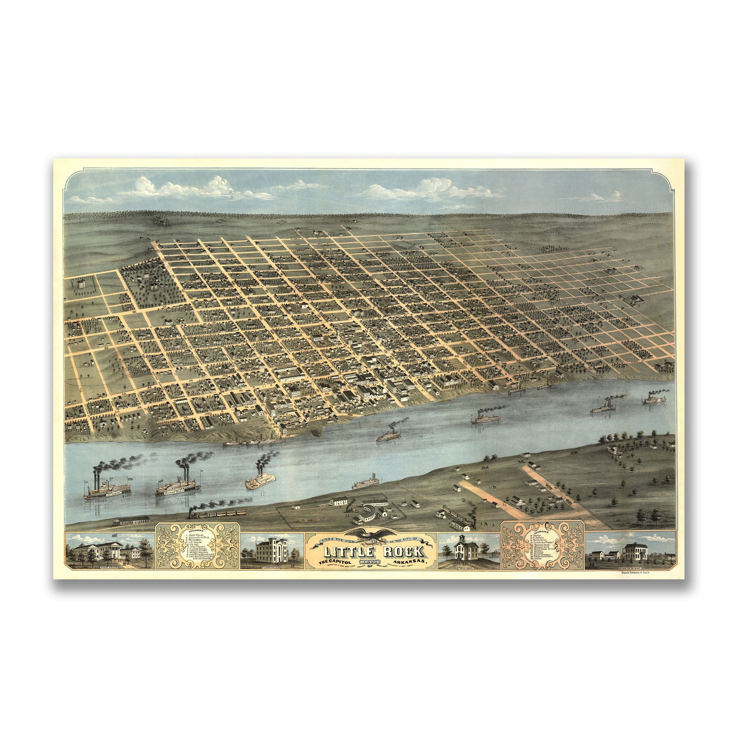
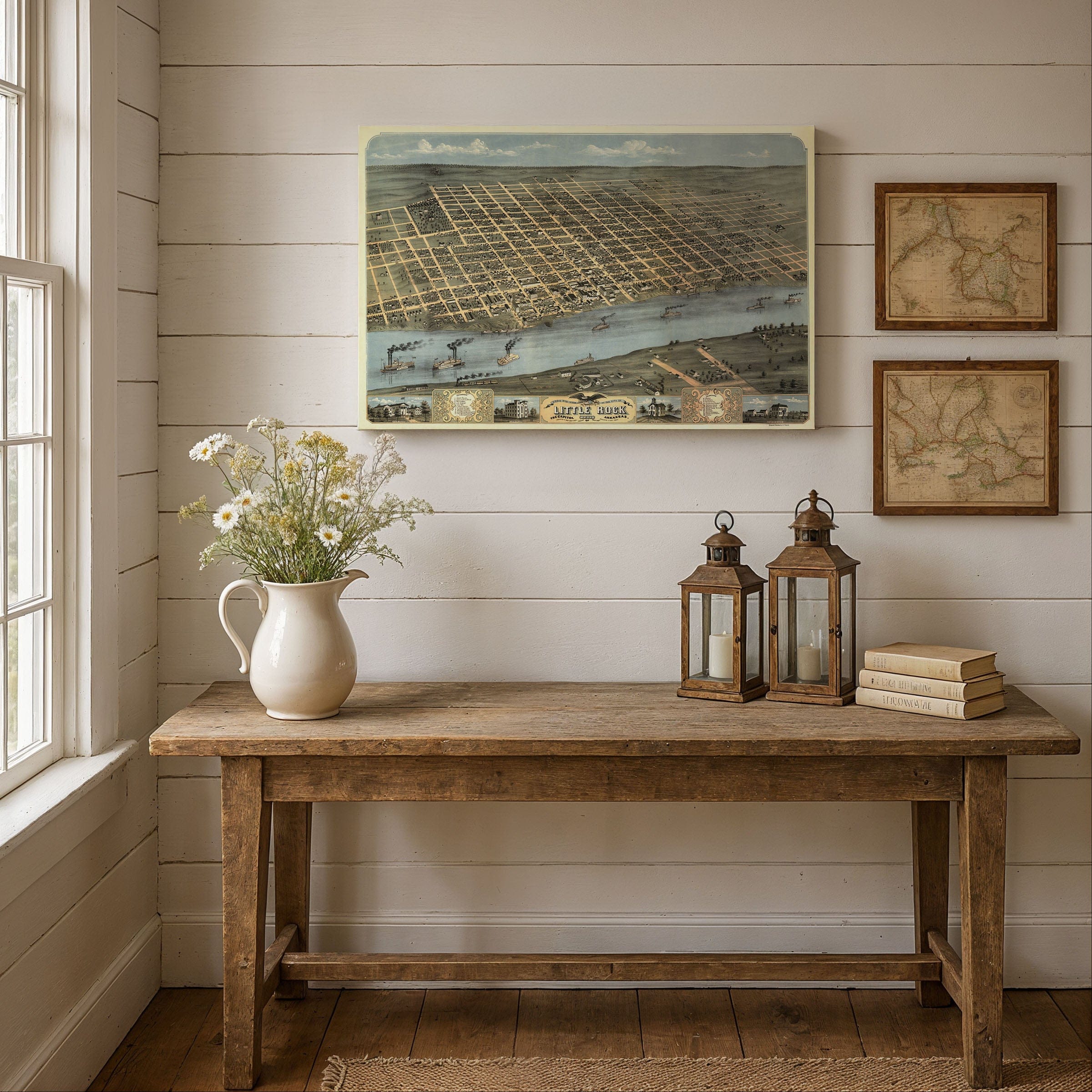
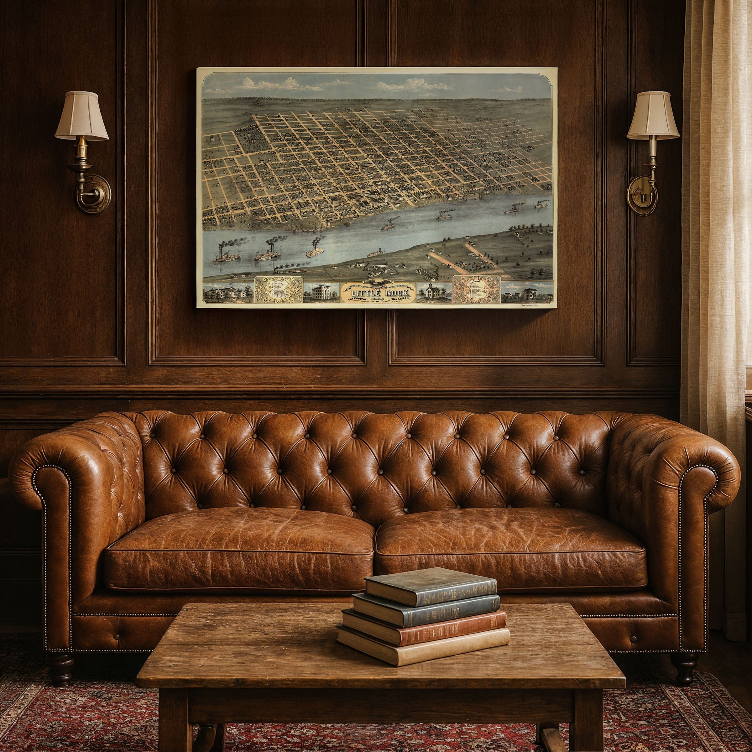
Travel back to 1887, when the Little Rock Arkansas Map revealed a city in motion—bridging its frontier past with the promise of a modern Southern capital. This panoramic map by Henry Wellge captures the Arkansas capital at the height of its Gilded Age optimism, when railroads, riverboats, and commerce defined the rhythm of daily life along the Arkansas River bluffs.Historical Significance of This Little Rock Arkansas Map
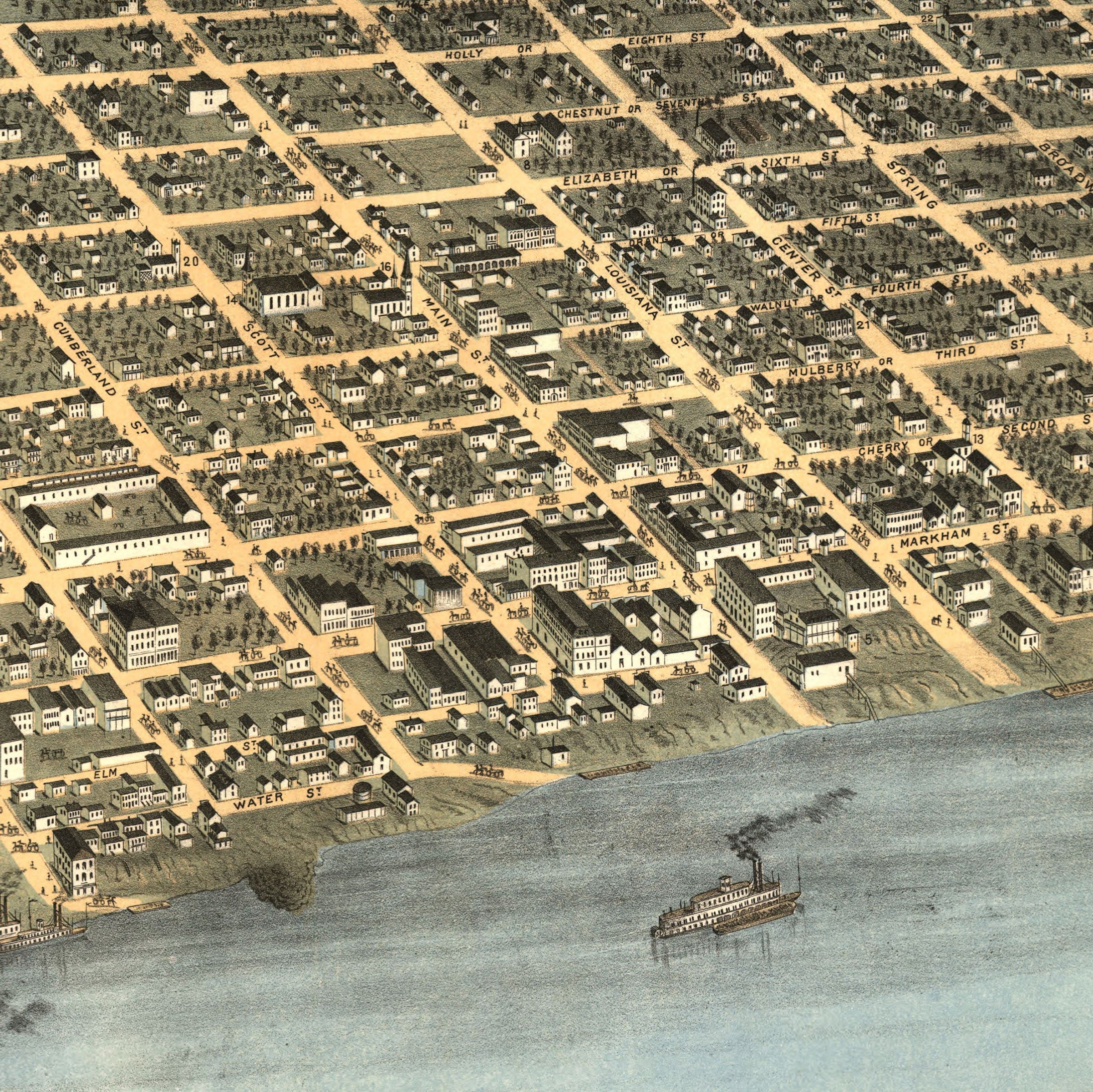
Spread across the bluffs of the Arkansas River, this remarkable perspective looks north from a bird's-eye vantage, revealing a meticulously organized city that had grown from a rough trading post into the heart of the state's political and economic life. At the river's edge, paddlewheel steamers and freight barges bustle between docks, carrying cotton, timber, and goods to and from the Delta and beyond. The great bridges connecting Little Rock with Argenta (now North Little Rock) stand as symbols of connection and progress. Downtown, a grid of busy streets lines the riverbank—Commerce, Main, and Markham Streets—where hotels, warehouses, and civic buildings form the city's commercial core. Smoke from factories and locomotives drifts upward, marking the arrival of industry. The Arkansas Gazette, whose office commissioned this map, was already one of the oldest newspapers west of the Mississippi, chronicling the city's transformation in real time.Transportation Hub and Urban Development
The view also captures the city's neighborhoods rising from the river valley toward the hills. Churches, schools, and public buildings dot the landscape, signaling stability and ambition. The Arkansas State Capitol—then housed in the old Statehouse—anchors the civic center, while the surrounding grid hints at the city's growing confidence. To the east, the rail yards hum with activity, connecting Little Rock to Memphis, St. Louis, and New Orleans. By the 1880s, Little Rock had fully embraced its role as a transportation hub. Rail lines brought travelers and trade from every direction, while the Arkansas River remained a vital artery for regional commerce. The city's population had swelled past 20,000, and new construction reflected a belief that Little Rock was destined to become a modern metropolis.A Vision of Southern Progress
Henry Wellge's drawing immortalizes that moment of balance—between the elegance of the old South and the energy of the new industrial age. His map invites the viewer to step into a city alive with purpose, perched confidently on the edge of change. Each reproduction includes a custom historical letter detailing the story behind the map, making it perfect for collectors, historians, and Arkansas heritage enthusiasts. Printed on heavyweight archival paper or hand-stretched polycotton canvas, every street, building, and riverboat detail is restored in museum-grade clarity for generations of enjoyment. Paper prints ship rolled in heavy-duty tubes, while canvas editions arrive gallery-wrapped on solid pine stretcher bars with pre-installed hardware—ready to display the moment it arrives. Bring home a piece of Arkansas's transformative legacy and celebrate the vision that made Little Rock the heart of the Natural State.The Map Story
Materials
Choose options

Because every place has a story
Make History Personal
A vintage map is more than art.
It is a reminder of where life began.
Where memories were made.
Where hearts still live. Give the gift of place.
Beautifully preserved and made for the moments that matter.
Why Choose Us?
| Feature | Us | Competitor A | Competitor B |
|---|---|---|---|
| Hand Crafted | |||
| Museum Quality | |||
| 100 Year Guarantee | |||
| Restored by Hand | |||
| Certificate of Authenticity |

Art Prints
Archival quality colors. Best option if you'd like to frame it yourself

The Best Materials
We hand-stretched our canvas on solid American-grown pine stretcher bars. We use quality canvas and fade-resistant inks to create the lasting art. Canvases come with hardware already installed and ready to hang.
Need help?
Frequently Asked Questions
Order
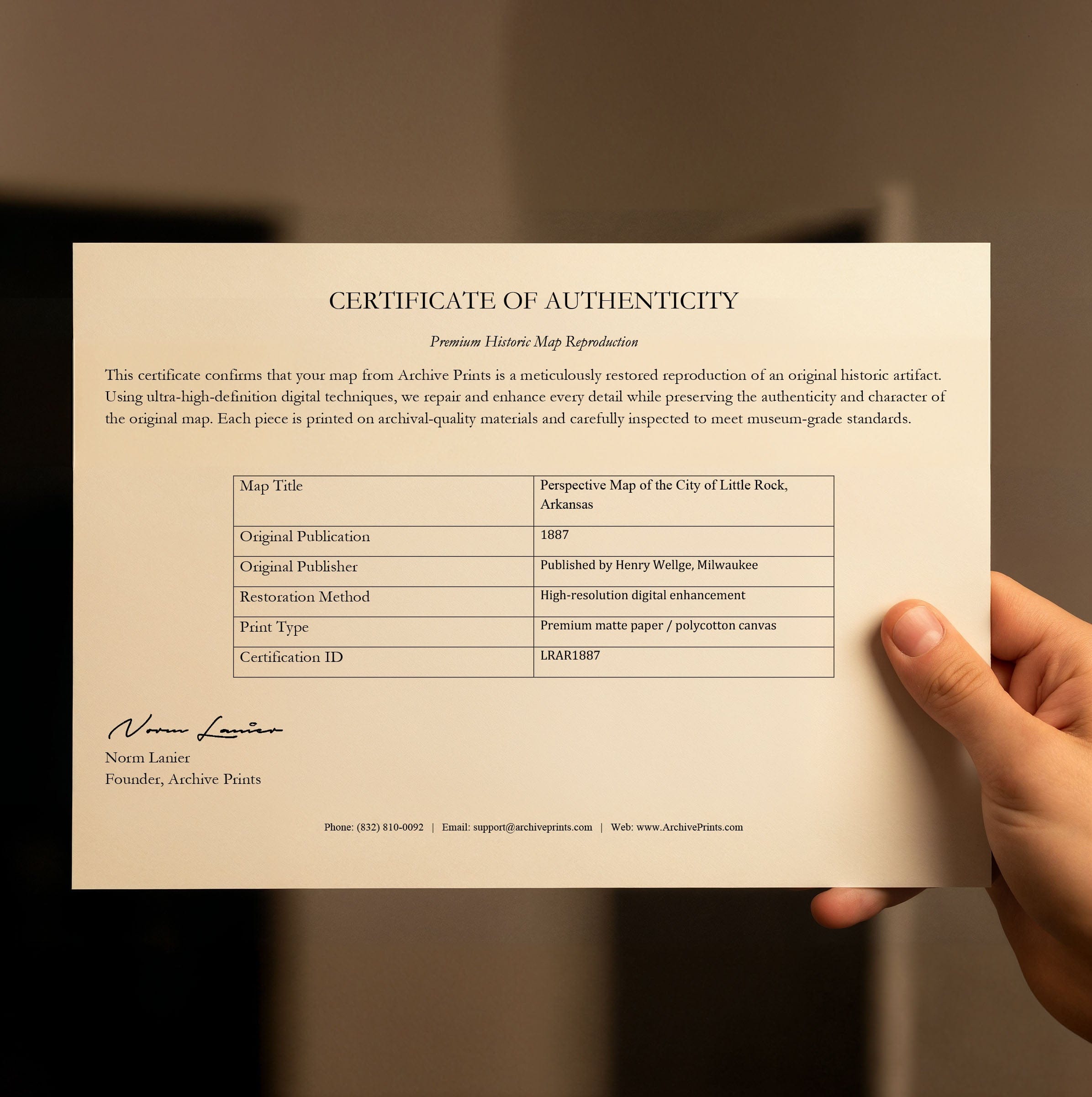
All of our maps are meticulously restored reproductions of historic originals. Each piece is digitally repaired and color-corrected to bring out the finest details while preserving its authentic, vintage character.
Yes. All Archive Prints products are printed to order in the USA with archival materials.
We offer two premium formats:
- High-Quality Paper Posters – Printed on thick, archival-grade matte paper for rich, vibrant detail.
- Hand-Stretched Canvas Prints – Printed on premium polycotton canvas and mounted on 1.5" solid American pine stretcher bars for a gallery-quality finish.
We carefully digitally restore each map to enhance clarity and color while preserving its original look and historic charm. You’ll enjoy sharp details and a timeless vintage aesthetic that feels true to the original piece.
Yes, we do! We offer premium framing options to make your map ready to hang the moment it arrives. You can choose from Oak, Maple, Black, or Walnut frames directly on the product page. We also offer Stretched Canvas prints for a modern gallery look, as well as archival-quality Posters if you prefer to frame it yourself.
Yes! We offer free shipping on all products within the United States. Each map is carefully packaged to ensure it arrives in perfect condition.
If you’re not completely satisfied, you can return your order in new condition for a full refund. Return shipping costs are the responsibility of the customer.
Absolutely! Our maps make thoughtful, one-of-a-kind gifts for history lovers, map collectors, or anyone looking to add vintage character to their home or office. Choose between paper prints for framing or stretched canvas for a ready-to-hang presentation.
- Paper Posters → Shipped in durable, protective tubes to prevent creasing.
- Canvas Prints → Carefully wrapped, padded, and boxed to ensure safe delivery.
Our maps look stunning in a variety of settings, including:
- Living rooms and home offices
- Libraries and studies
- Corporate offices and conference rooms
- Restaurants, cafes, and boutique spaces