
Llano County Vintage Map - Antique 1879 Texas General Land Office Map
Discover the Heart of the Texas Hill Country
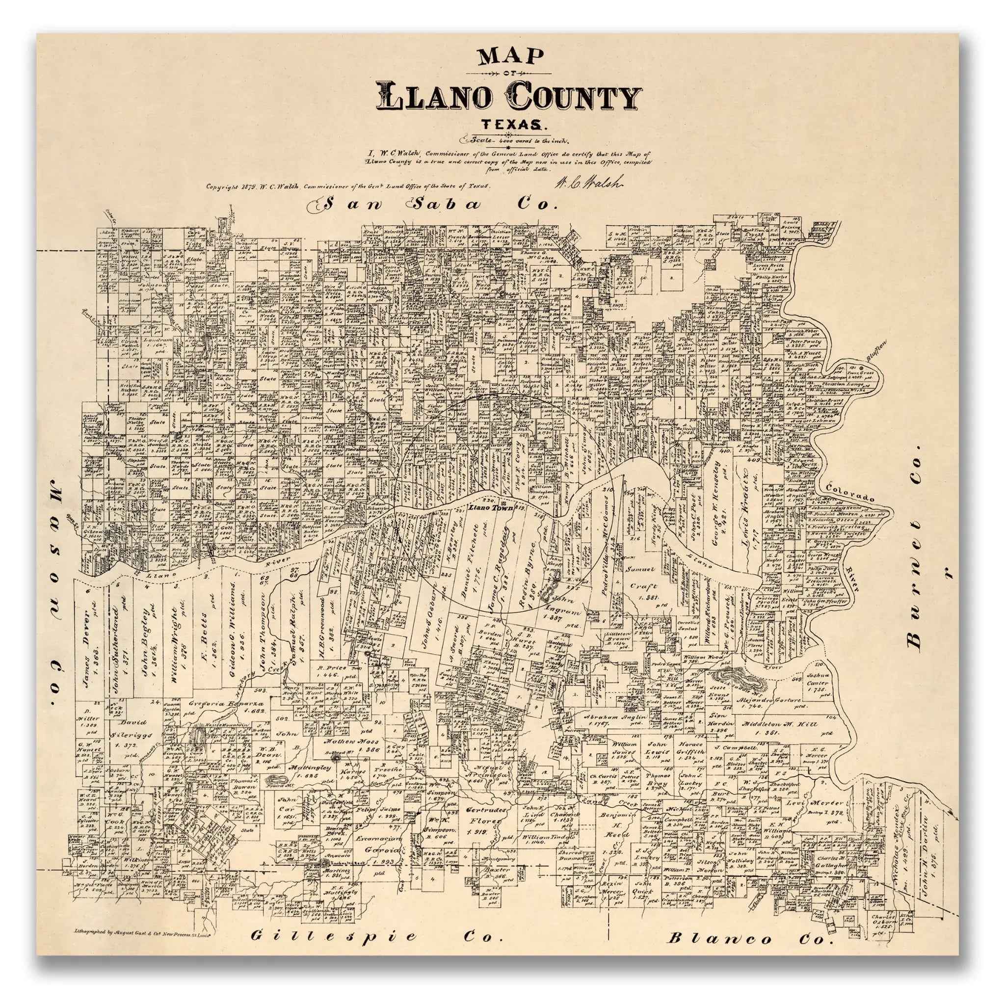
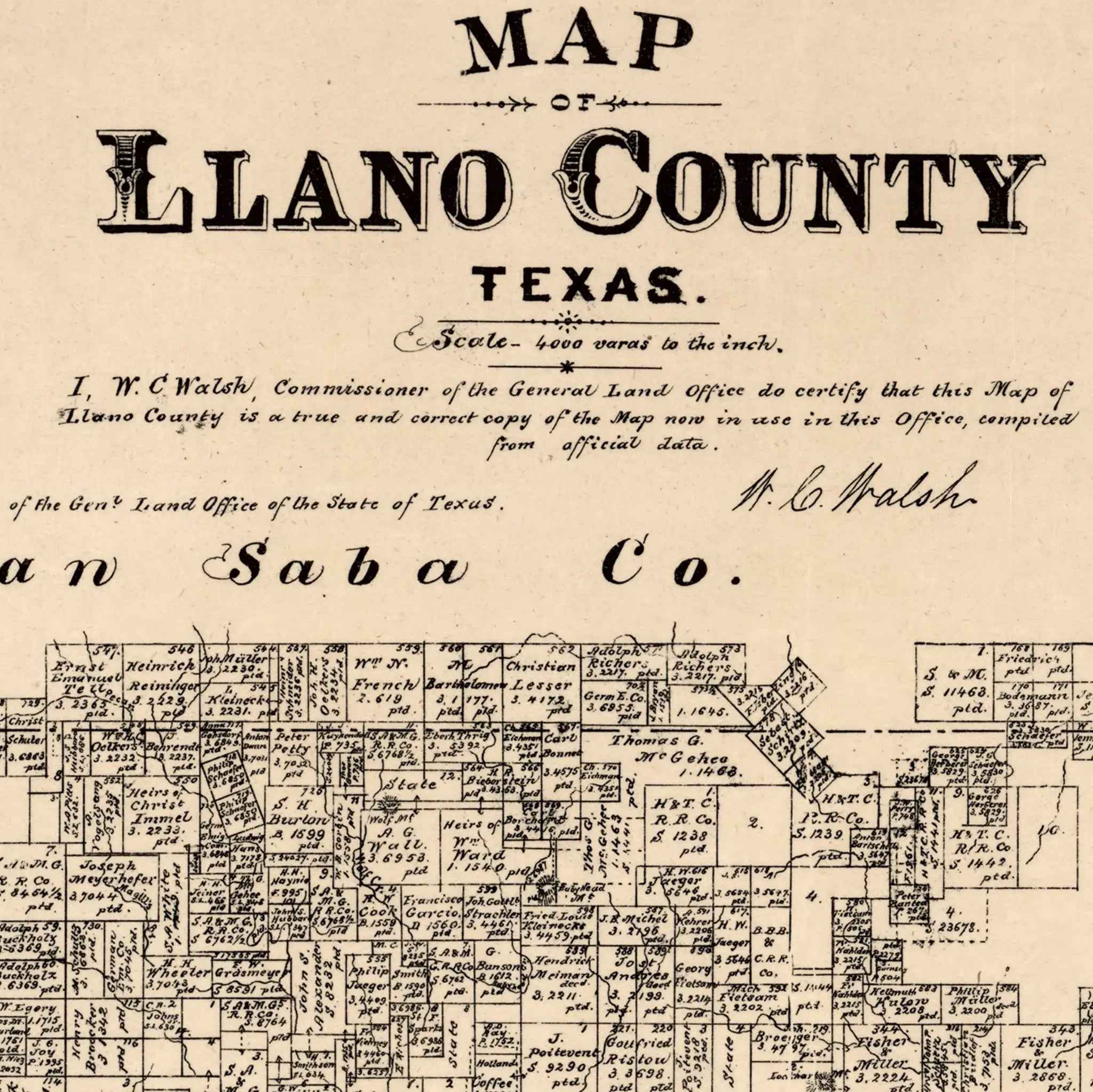
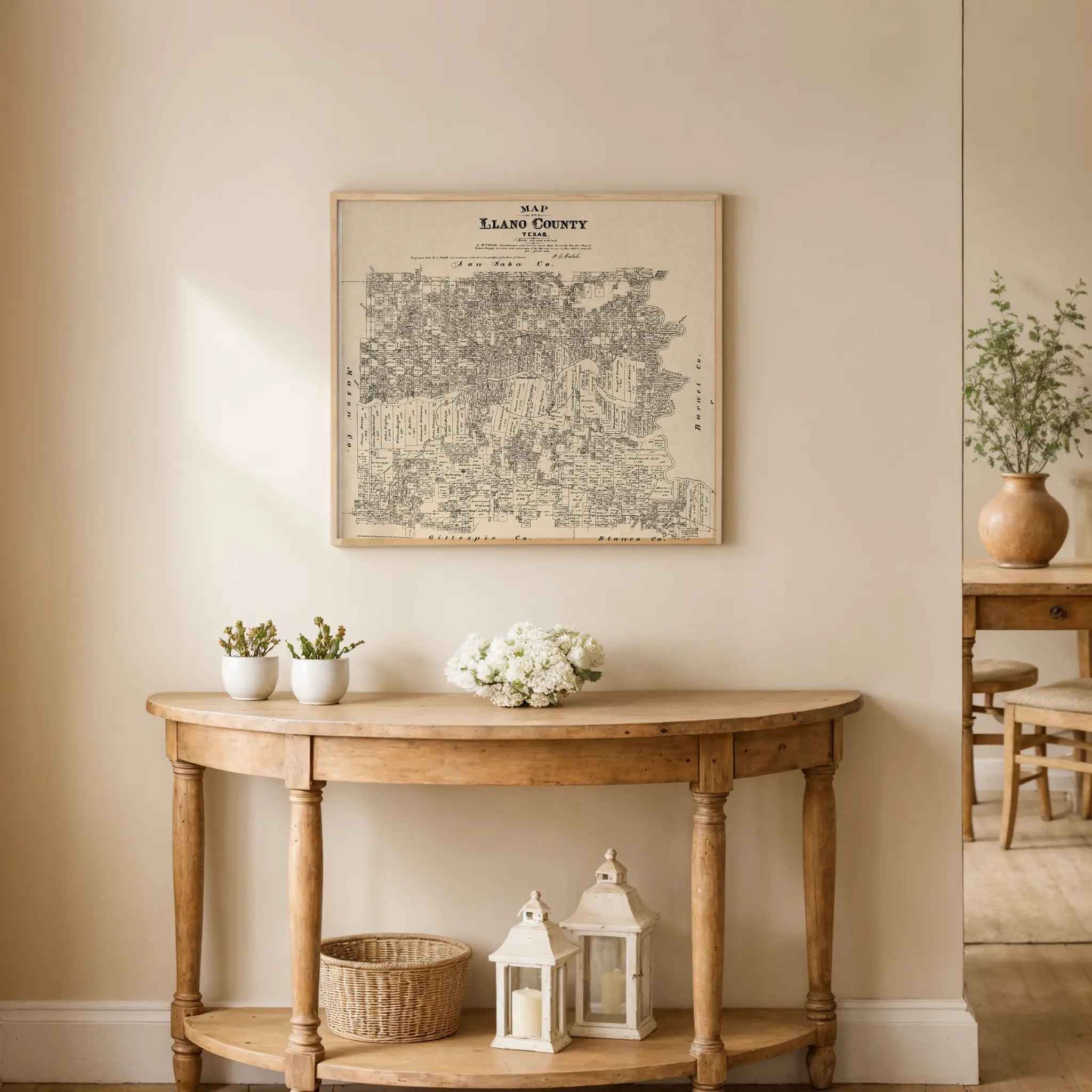
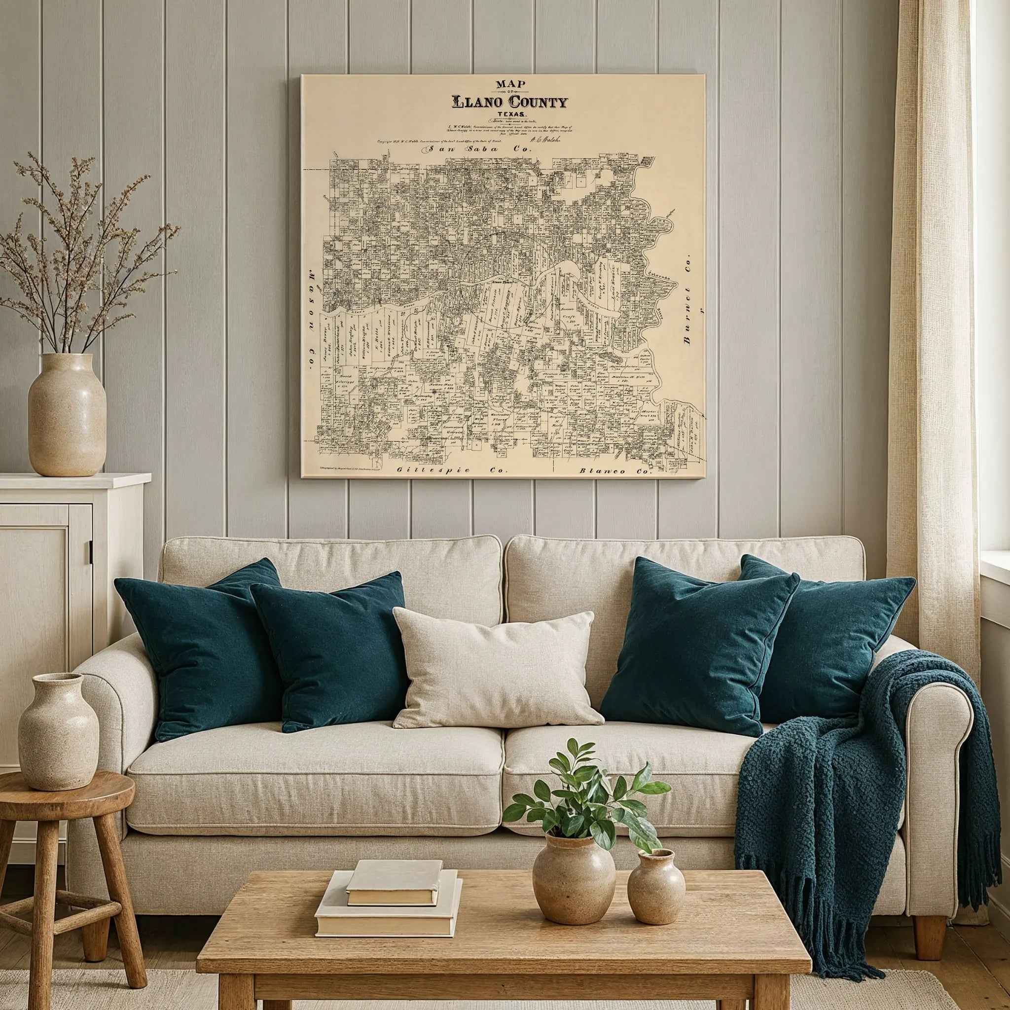
Explore the rugged beauty and pioneer spirit of the Hill Country with this meticulously restored 1879 Llano County Map produced under the direction of W. C. Walsh, Commissioner of the Texas General Land Office. This remarkable historical map captures Llano County during its frontier years—when settlers, surveyors, and ranchers were transforming untamed land into thriving communities along the winding Llano River.
Created at a time when Texas was still defining its western boundaries, this map details the early ranches, farms, and settlements that formed the backbone of Hill Country life. Each tract of land bears the name of its original grantee, preserving the legacy of Republic-era grants and the expansion that followed. From the granite outcrops of the Llano Uplift to the fertile river valleys, every inch of the map reveals the natural resources and frontier determination that shaped the county’s identity.
The map also records the early wagon routes linking Llano to Burnet, Mason, and Blanco, echoing the slow but steady advance of civilization through the Hill Country’s wild terrain. Absent are the railroads that would come later—this is a portrait of Llano before industry arrived, when life was measured by distance, endurance, and connection to the land.
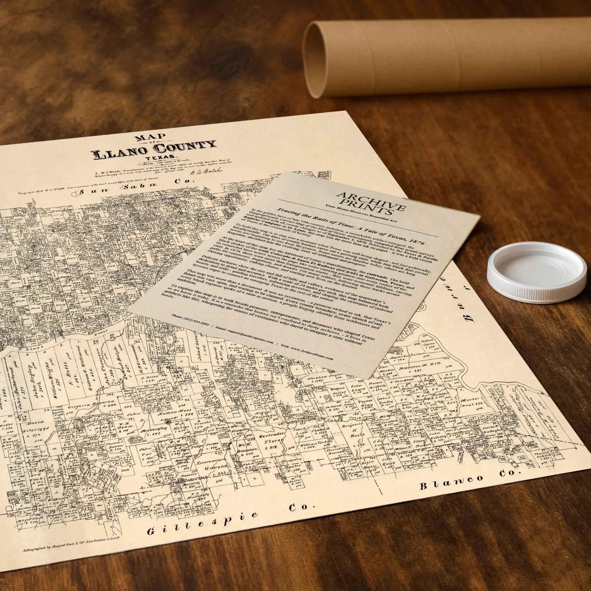
Each reproduction includes a custom historical letter detailing the map’s significance, making it an ideal centerpiece for collectors, historians, and proud Texans alike. Printed with precision on heavyweight archival paper or hand-stretched premium canvas, every survey line, river bend, and land grant is brought to life with museum-grade clarity through expert digital restoration.
Paper prints arrive rolled in sturdy mailing tubes, while canvas prints come gallery-wrapped on solid pine stretcher bars with pre-installed hardware—ready to display the moment it arrives.
Bring home a piece of Texas heritage and celebrate the Hill Country’s frontier legacy with this striking 1879 Llano County map.
The Map Story
This 1879 map of Llano County was compiled under the direction of W. C. Walsh, Commissioner of the Texas General Land Office. It illustrates a rugged region of the Texas Hill Country at a time when settlement was steadily pushing westward from the older counties of Central Texas. Formed in 1856, Llano County was still a frontier community in the 1870s, defined by its granite hills, the winding Llano River, and scattered ranching settlements that would later grow into established towns.
The map is filled with land grants, each labeled with the name of the original grantee, many of them dating back to the Republic of Texas. These parcels tell the story of how land distribution encouraged migration into the Hill Country, attracting ranchers, farmers, and prospectors. The town of Llano, designated as the county seat, is marked along the Llano River, where trade and civic life centered. Other settlements such as Bluffton and Prairie Mountain appear as small clusters, showing the dispersed nature of habitation in a county defined by rugged terrain.
Natural features dominate the map. The Llano River cuts eastward across the county, fed by tributaries such as Sandy Creek and the North and South Llano rivers nearby. The granite outcrops of the region, precursors to the famed Llano Uplift, are noted in survey lines and elevations. This geology would later give rise to the stone industry and eventually the discovery of valuable minerals, but in 1879 the land was primarily valued for its grazing and fertile valleys.
Transportation routes are limited, reflecting the county’s frontier character. Early wagon roads connect Llano to Burnet to the east and Mason to the west. These paths carried cattle, agricultural goods, and supplies across the Hill Country. The absence of railroads on the map underscores how isolated Llano remained in the 1870s compared to counties closer to Austin or San Antonio.
By 1879, Llano County was transitioning from a sparsely populated frontier to a more settled ranching community. The map captures this moment, when land grants and survey lines represented the promise of development, even as the county remained shaped by its rivers, granite hills, and isolation. Today, the 1879 Llano County map stands as both a cartographic record and a cultural artifact, preserving the early outlines of a Hill Country county that would later be celebrated for its natural beauty and resources.
Materials
Hand‑Stretched Canvas: If you choose canvas, we use a premium cotton‑poly blend stretched over solid pine frames. Each canvas is carefully hand‑stretched for a tight, gallery‑quality finish that's ready to hang right out of the box.
Vivid, Fade‑Resistant Inks: We use professional‑grade inks that are UV‑resistant, so your print retains its rich colors even when displayed in bright rooms.
Expert Restoration: Every map is digitally restored by skilled artisans. We preserve the character of the original while enhancing clarity, so you see the map as it was meant to be seen.
Secure Packaging: Paper prints are rolled in heavy‑duty mailing tubes, and canvases are cushioned in reinforced boxes to ensure they arrive in pristine condition.
Choosing one of our prints means investing in craftsmanship. We combine historical authenticity with modern print technology and premium materials, giving you a work of art built to stand the test of time.
Choose options

Because every place has a story
Make History Personal
A vintage map is more than art.
It is a reminder of where life began.
Where memories were made.
Where hearts still live. Give the gift of place.
Beautifully preserved and made for the moments that matter.
Why Choose Us?
| Feature | Us | Competitor A | Competitor B |
|---|---|---|---|
| Hand Crafted | |||
| Museum Quality | |||
| 100 Year Guarantee | |||
| Restored by Hand | |||
| Certificate of Authenticity |

Art Prints
Archival quality colors. Best option if you'd like to frame it yourself

The Best Materials
We hand-stretched our canvas on solid American-grown pine stretcher bars. We use quality canvas and fade-resistant inks to create the lasting art. Canvases come with hardware already installed and ready to hang.
Need help?
Frequently Asked Questions
Order
All of our maps are meticulously restored reproductions of historic originals. Each piece is digitally repaired and color-corrected to bring out the finest details while preserving its authentic, vintage character.
Yes. All Archive Prints products are printed to order in the USA with archival materials.
We offer two premium formats:
- High-Quality Paper Posters – Printed on thick, archival-grade matte paper for rich, vibrant detail.
- Hand-Stretched Canvas Prints – Printed on premium polycotton canvas and mounted on 1.5" solid American pine stretcher bars for a gallery-quality finish.
We carefully digitally restore each map to enhance clarity and color while preserving its original look and historic charm. You’ll enjoy sharp details and a timeless vintage aesthetic that feels true to the original piece.
Yes, we do! We offer premium framing options to make your map ready to hang the moment it arrives. You can choose from Oak, Maple, Black, or Walnut frames directly on the product page. We also offer Stretched Canvas prints for a modern gallery look, as well as archival-quality Posters if you prefer to frame it yourself.
Yes! We offer free shipping on all products within the United States. Each map is carefully packaged to ensure it arrives in perfect condition.
If you’re not completely satisfied, you can return your order in new condition for a full refund. Return shipping costs are the responsibility of the customer.
Absolutely! Our maps make thoughtful, one-of-a-kind gifts for history lovers, map collectors, or anyone looking to add vintage character to their home or office. Choose between paper prints for framing or stretched canvas for a ready-to-hang presentation.
- Paper Posters → Shipped in durable, protective tubes to prevent creasing.
- Canvas Prints → Carefully wrapped, padded, and boxed to ensure safe delivery.
Our maps look stunning in a variety of settings, including:
- Living rooms and home offices
- Libraries and studies
- Corporate offices and conference rooms
- Restaurants, cafes, and boutique spaces