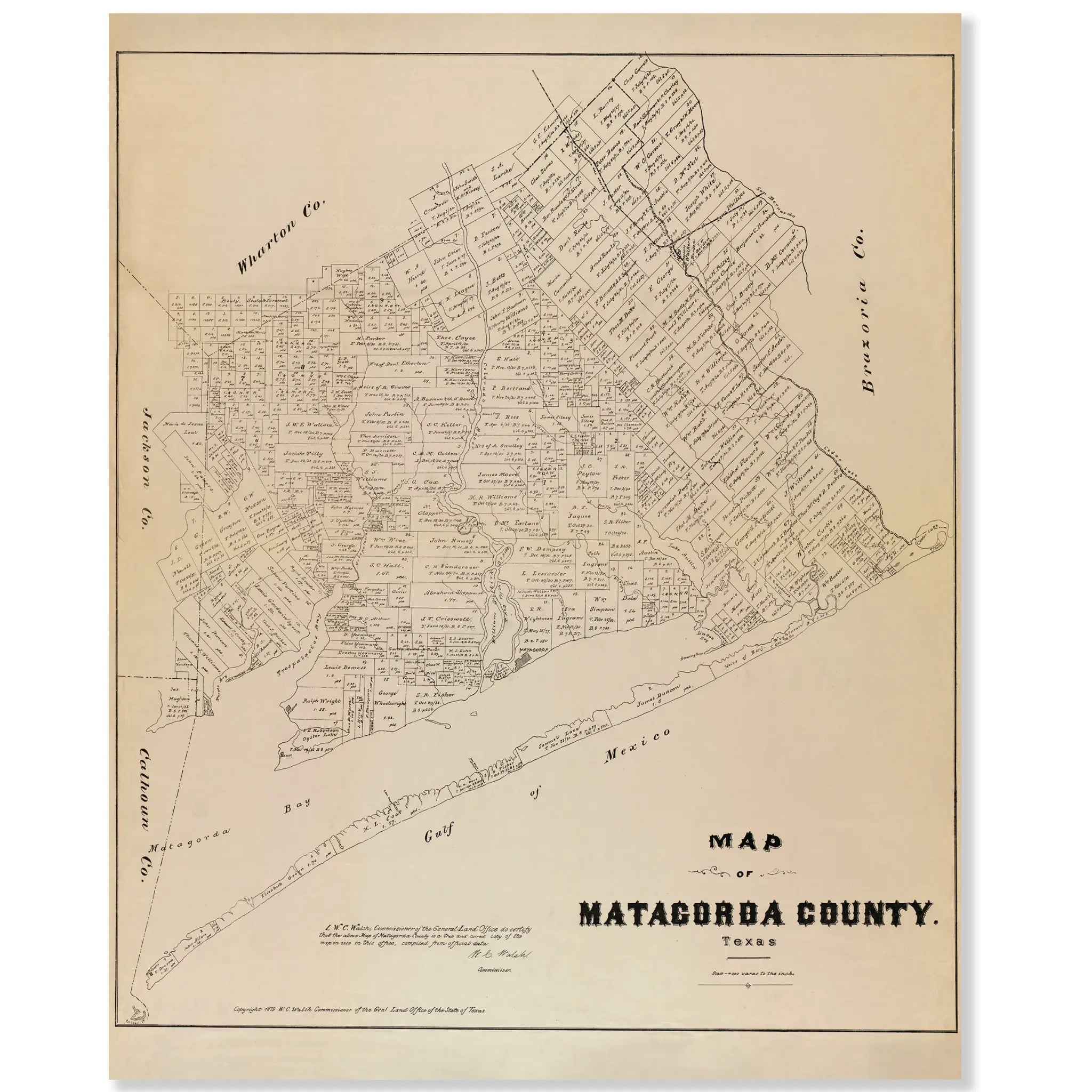
Matagorda County Vintage Map - 1879 Texas General Land Office Artwork
Discover Coastal Texas Heritage
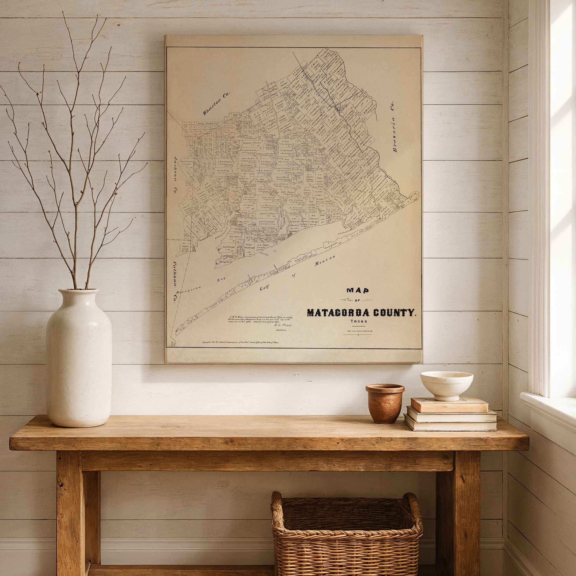
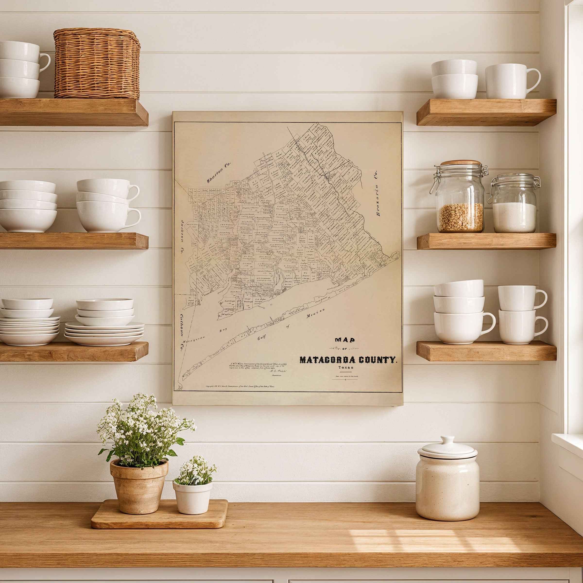
Step back to 1879 and explore one of Texas’s earliest coastal settlements with this beautifully restored Map of Matagorda County, originally produced under the direction of W. C. Walsh, Commissioner of the Texas General Land Office. This extraordinary piece of cartographic history captures a region where fertile prairies met the Gulf of Mexico, and where pioneers, planters, and traders forged communities that would help shape the Texas coast.
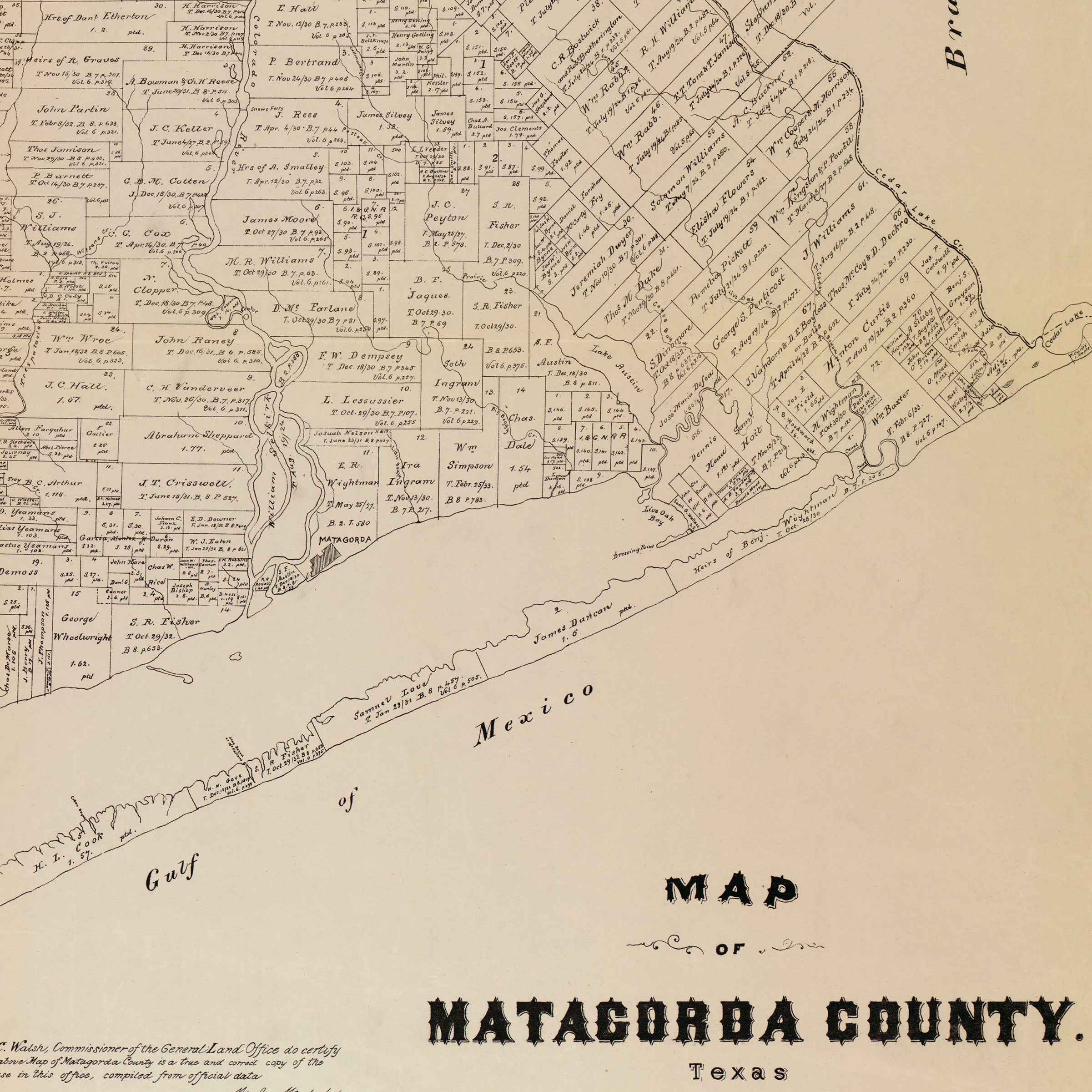
Covering a landscape rich in rivers, bays, and ranchlands, the map presents Matagorda County as it existed in the late 19th century—a place of vast opportunity and enduring resilience. Every inch is filled with historic land grants, handwritten survey markings, and the names of early settlers and families whose legacies still echo across the county today. The Colorado River winds through the center, emptying into Matagorda Bay, the vital artery that connected inland farms to shipping routes and the sea.
At the time this map was drawn, Matagorda was a growing center of commerce and agriculture. The region’s fertile soil supported cotton, rice, and sugar plantations, while ranchers raised herds on the open prairie. Along the coast, ships carried goods to and from Galveston and New Orleans, making the area an essential link between Texas’s inland settlements and global trade. This map not only documents these thriving enterprises—it also preserves the geography of resilience, where hurricanes, floods, and frontier hardship tested the determination of early Texans.
Printed with museum-grade clarity on premium archival paper or polycotton canvas, each reproduction showcases every hand-drawn parcel, survey line, and waterway with precision and authenticity. Perfect for collectors, historians, and proud Texans alike, this map stands as a tribute to the state’s coastal heritage and the pioneering spirit that defined it.
Bring home a tangible connection to Texas history—an enduring reminder of the people and places that helped shape life along the Gulf.
The Map Story
This 1879 map of Matagorda County was produced under the direction of W. C. Walsh, Commissioner of the Texas General Land Office. Located along the Gulf Coast, Matagorda County was one of the earliest settled areas of Texas, with a history stretching back to Spanish exploration and Mexican colonization. By 1879, it was a region where agriculture, ranching, and shipping converged, supported by fertile coastal prairies and access to bays and rivers that linked the county to wider trade networks.
The map is dominated by a patchwork of land grants, many tracing their origins to the Republic of Texas and Mexican empresario programs. Names of settlers, surveyors, and early families cover the sheet, preserving the legacy of colonization and migration that defined the county. Matagorda, the county seat, appears as a central town on the Colorado River near its mouth, a community once considered as a possible capital of the Republic due to its port access. Other communities such as Caney, Cedar Lake, and Trespalacios appear as smaller settlements serving farming and ranching districts.
Natural features play a vital role on this map. The Colorado River winds across the county, emptying into Matagorda Bay. Bays, inlets, and barrier islands frame the southern edge, with the Gulf of Mexico beyond. These waters supported shipping, fishing, and trade, and also posed challenges in the form of hurricanes and shifting sandbars. The prairies inland provided fertile soil for cotton, sugar, and rice, while vast grasslands sustained cattle herds driven to markets along the coast.
Transportation routes include wagon roads linking Matagorda to interior towns and emerging rail connections that would eventually tie the Gulf Coast to Houston and beyond. Although still remote compared to larger Texas cities, Matagorda County in 1879 was strategically positioned as both an agricultural heartland and a coastal outlet for trade.
This map captures a county that balanced frontier legacy with coastal opportunity. It preserves the land divisions, waterways, and communities of an area that played an outsized role in early Texas history and continued to support settlement and commerce into the late nineteenth century. Today the 1879 Matagorda County map endures as both a cartographic record and a cultural artifact, illustrating how geography and history combined to shape life along the Texas Gulf Coast.
Materials
Hand‑Stretched Canvas: If you choose canvas, we use a premium cotton‑poly blend stretched over solid pine frames. Each canvas is carefully hand‑stretched for a tight, gallery‑quality finish that's ready to hang right out of the box.
Vivid, Fade‑Resistant Inks: We use professional‑grade inks that are UV‑resistant, so your print retains its rich colors even when displayed in bright rooms.
Expert Restoration: Every map is digitally restored by skilled artisans. We preserve the character of the original while enhancing clarity, so you see the map as it was meant to be seen.
Secure Packaging: Paper prints are rolled in heavy‑duty mailing tubes, and canvases are cushioned in reinforced boxes to ensure they arrive in pristine condition.
Choosing one of our prints means investing in craftsmanship. We combine historical authenticity with modern print technology and premium materials, giving you a work of art built to stand the test of time.
Choose options

Because every place has a story
Make History Personal
A vintage map is more than art.
It is a reminder of where life began.
Where memories were made.
Where hearts still live. Give the gift of place.
Beautifully preserved and made for the moments that matter.
Why Choose Us?
| Feature | Us | Competitor A | Competitor B |
|---|---|---|---|
| Hand Crafted | |||
| Museum Quality | |||
| 100 Year Guarantee | |||
| Restored by Hand | |||
| Certificate of Authenticity |

Art Prints
Archival quality colors. Best option if you'd like to frame it yourself

The Best Materials
We hand-stretched our canvas on solid American-grown pine stretcher bars. We use quality canvas and fade-resistant inks to create the lasting art. Canvases come with hardware already installed and ready to hang.
Need help?
Frequently Asked Questions
Order
All of our maps are meticulously restored reproductions of historic originals. Each piece is digitally repaired and color-corrected to bring out the finest details while preserving its authentic, vintage character.
Yes. All Archive Prints products are printed to order in the USA with archival materials.
We offer two premium formats:
- High-Quality Paper Posters – Printed on thick, archival-grade matte paper for rich, vibrant detail.
- Hand-Stretched Canvas Prints – Printed on premium polycotton canvas and mounted on 1.5" solid American pine stretcher bars for a gallery-quality finish.
We carefully digitally restore each map to enhance clarity and color while preserving its original look and historic charm. You’ll enjoy sharp details and a timeless vintage aesthetic that feels true to the original piece.
Yes, we do! We offer premium framing options to make your map ready to hang the moment it arrives. You can choose from Oak, Maple, Black, or Walnut frames directly on the product page. We also offer Stretched Canvas prints for a modern gallery look, as well as archival-quality Posters if you prefer to frame it yourself.
Yes! We offer free shipping on all products within the United States. Each map is carefully packaged to ensure it arrives in perfect condition.
If you’re not completely satisfied, you can return your order in new condition for a full refund. Return shipping costs are the responsibility of the customer.
Absolutely! Our maps make thoughtful, one-of-a-kind gifts for history lovers, map collectors, or anyone looking to add vintage character to their home or office. Choose between paper prints for framing or stretched canvas for a ready-to-hang presentation.
- Paper Posters → Shipped in durable, protective tubes to prevent creasing.
- Canvas Prints → Carefully wrapped, padded, and boxed to ensure safe delivery.
Our maps look stunning in a variety of settings, including:
- Living rooms and home offices
- Libraries and studies
- Corporate offices and conference rooms
- Restaurants, cafes, and boutique spaces