


Montgomery County Vintage Map - Authentic 1880 Texas General Land Office Design
Discover Montgomery County's Frontier Legacy
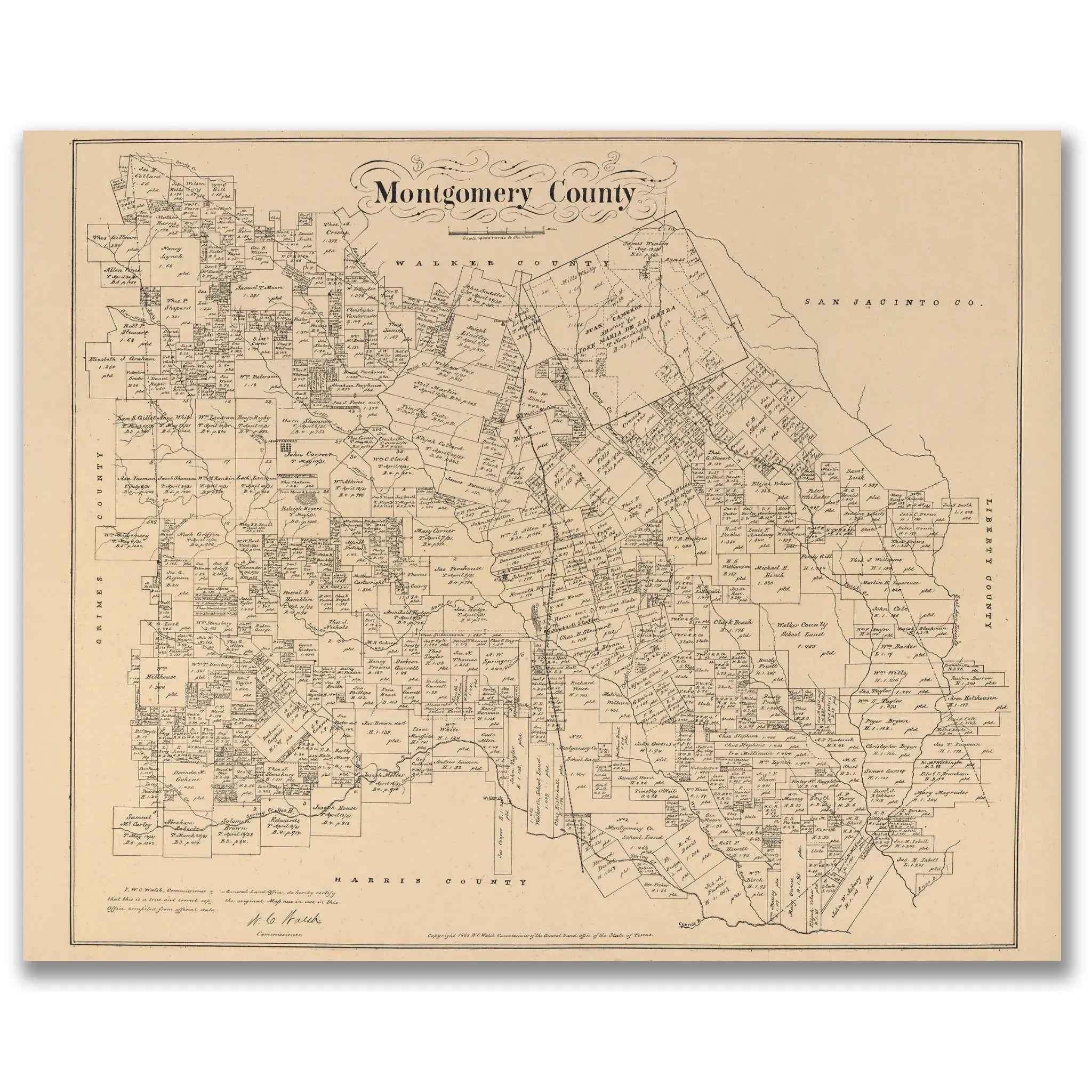
Step into the remarkable world of 1880 Montgomery County with this meticulously detailed General Land Office map that captures the East Texas Piney Woods during the height of frontier settlement and timber industry development. This extraordinary cartographic document by W.C. Walsh, Commissioner of the General Land Office of Texas, reveals Montgomery County as a complex tapestry of individual land grants, family homesteads, and emerging communities that would define the character of this forested region north of Houston.
Historical Significance
In 1880, Montgomery County stood as a testament to the successful Anglo-American settlement of East Texas that began in the 1820s and 1830s. This official General Land Office map documents the county during a crucial period when timber barons, small farmers, and railroad developers were transforming the dense pine forests into a thriving agricultural and lumber-producing region. The map showcases the systematic division of land into individual parcels, each bearing the names of the pioneering families who cleared homesteads from the virgin timber and built the foundations of what would become one of Texas's most important forestry regions.
Cartographic Excellence
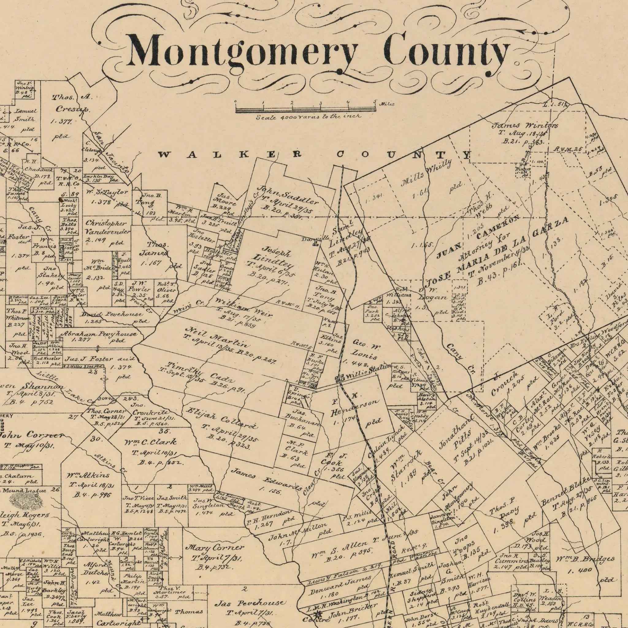
This masterful survey map showcases the meticulous precision of 19th-century Texas land documentation in the challenging terrain of the East Texas forests. Every section, survey line, and property boundary is carefully delineated, creating a comprehensive record of land ownership that served both legal and practical purposes. The map reveals the complex patchwork of land grants, from large timber holdings to smaller family farms, showing how the county was systematically settled despite the challenges of dense forest and swampy bottomlands. Neighboring counties—Walker, Grimes, Waller, Harris, and San Jacinto—are clearly marked, providing geographical context for this East Texas woodland region.
Settlement Story
Within the detailed survey lines, the story of East Texas pioneer settlement unfolds through individual landowner names that reflect the county's diverse heritage of Anglo-American settlers, many arriving from the Old South. The map captures the essence of a community built by families who brought cotton farming, cattle ranching, and timber harvesting to the Piney Woods, establishing farms, sawmills, and small towns that balanced agricultural traditions with the emerging lumber industry. Each named parcel represents a family's vision of prosperity in the timber-rich lands of East Texas, creating a mosaic of settlement that made Montgomery County a distinctive blend of Southern agricultural tradition and frontier enterprise.
Piney Woods Heritage
Beyond its function as a legal document, this map represents the vision and determination of the settlers who transformed the East Texas forests into a thriving agricultural and timber region. The careful documentation of creeks, rivers, and natural features reveals how settlers adapted their farming and logging techniques to the unique environment of the Piney Woods. The presence of communities like Conroe, Montgomery, and Willis, along with numerous sawmill sites, hints at the industrial development that would make this region crucial to Texas's lumber industry while maintaining its agricultural character.
This detailed cartographic record preserves Montgomery County at a pivotal moment in its development—when the pioneer generation was establishing the institutions and industries that would define the region for generations to come. The map captures the essence of a community that valued both individual enterprise and collective cooperation, creating a unique East Texas culture that balanced agricultural tradition with timber industry innovation. Perfect for collectors of Texas history, East Texas heritage enthusiasts, and those with connections to the Piney Woods region, this restored map serves as both a genealogical treasure and a stunning piece of wall art that celebrates the vision and perseverance that built one of Texas's most distinctive forested counties.
Each reproduction includes a custom historical letter detailing Montgomery County's role in East Texas settlement and the unique timber and agricultural heritage that made the Piney Woods a distinctive part of the Lone Star State. Printed on heavyweight archival paper or premium canvas, every property line, landowner name, and geographical feature is preserved with museum-quality clarity through expert digital restoration.
For protection and presentation, paper prints arrive rolled in sturdy mailing tubes, while canvas prints come gallery-wrapped on solid pine stretcher bars with pre-installed hanging hardware—ready to display immediately.
Bring home a piece of East Texas history with this captivating glimpse into Montgomery County's pioneer heritage and the timber industry that shaped the Piney Woods.
The Map Story
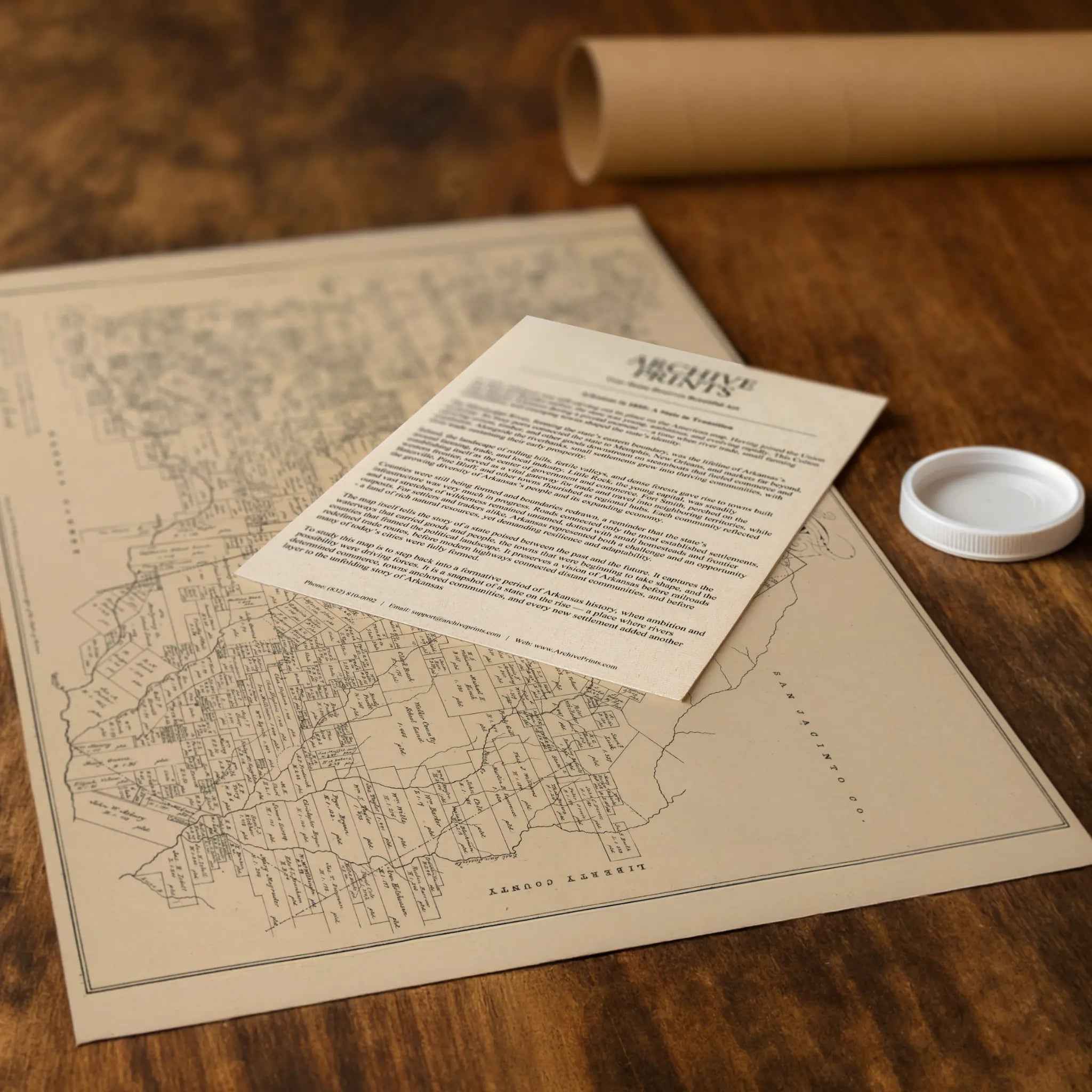
This 1879 map of Montgomery County was compiled under the direction of W. C. Walsh, Commissioner of the Texas General Land Office. It presents a county in East Texas that had already played an important role in the history of the Republic and early statehood, and which was continuing to grow as railroads and farms reshaped the landscape. The county, created in 1837, was the birthplace of the Texas Lone Star flag and a key settlement region between Houston and the pine forests to the north.
The map shows Montgomery County divided into hundreds of land grants, each labeled with the name of the original grantee. Many of these tracts date back to the Republic of Texas era, reflecting the distribution of land as rewards for service or as enticements for settlement. Names still familiar in the region—Smith, McDade, and Shepard among others—cover the sheet, preserving the memory of the county’s earliest families. The clear survey lines also show how Texas organized its public lands into a patchwork that encouraged migration and development.
Natural features frame the map. The San Jacinto River cuts through the eastern portion of the county, eventually joining the waters that flow toward Houston and Galveston Bay. The pine forests and rolling terrain of Montgomery provided timber, grazing land, and fertile soil for farms. These resources supported both subsistence agriculture and commercial crops, tying Montgomery into the wider markets of Southeast Texas.
The county seat of Montgomery, once a significant trade town, is depicted along with other settlements such as Huntsville to the north and Harris County to the south. By 1879, Conroe was emerging as a lumber hub, though it would not become the county seat until later. Roads and early rail connections shown on the map highlight how the county’s future growth would depend on transportation links with Houston and beyond.
Montgomery County’s 1879 map captures the transition from frontier land grants to a more settled, organized community. It reveals a society rooted in the legacies of independence and land distribution, yet poised for modernization through railroads, markets, and migration. Today, it stands as both a cartographic record and a cultural artifact, preserving the outlines of a county that would evolve into one of the fastest-growing regions of modern Texas.
Materials
Hand‑Stretched Canvas: If you choose canvas, we use a premium cotton‑poly blend stretched over solid pine frames. Each canvas is carefully hand‑stretched for a tight, gallery‑quality finish that's ready to hang right out of the box.
Vivid, Fade‑Resistant Inks: We use professional‑grade inks that are UV‑resistant, so your print retains its rich colors even when displayed in bright rooms.
Expert Restoration: Every map is digitally restored by skilled artisans. We preserve the character of the original while enhancing clarity, so you see the map as it was meant to be seen.
Secure Packaging: Paper prints are rolled in heavy‑duty mailing tubes, and canvases are cushioned in reinforced boxes to ensure they arrive in pristine condition.
Choosing one of our prints means investing in craftsmanship. We combine historical authenticity with modern print technology and premium materials, giving you a work of art built to stand the test of time.
Choose options

Because every place has a story
Make History Personal
A vintage map is more than art.
It is a reminder of where life began.
Where memories were made.
Where hearts still live. Give the gift of place.
Beautifully preserved and made for the moments that matter.
Why Choose Us?
| Feature | Us | Competitor A | Competitor B |
|---|---|---|---|
| Hand Crafted | |||
| Museum Quality | |||
| 100 Year Guarantee | |||
| Restored by Hand | |||
| Certificate of Authenticity |

Art Prints
Archival quality colors. Best option if you'd like to frame it yourself

The Best Materials
We hand-stretched our canvas on solid American-grown pine stretcher bars. We use quality canvas and fade-resistant inks to create the lasting art. Canvases come with hardware already installed and ready to hang.
Need help?
Frequently Asked Questions
Order
All of our maps are meticulously restored reproductions of historic originals. Each piece is digitally repaired and color-corrected to bring out the finest details while preserving its authentic, vintage character.
Yes. All Archive Prints products are printed to order in the USA with archival materials.
We offer two premium formats:
- High-Quality Paper Posters – Printed on thick, archival-grade matte paper for rich, vibrant detail.
- Hand-Stretched Canvas Prints – Printed on premium polycotton canvas and mounted on 1.5" solid American pine stretcher bars for a gallery-quality finish.
We carefully digitally restore each map to enhance clarity and color while preserving its original look and historic charm. You’ll enjoy sharp details and a timeless vintage aesthetic that feels true to the original piece.
Yes, we do! We offer premium framing options to make your map ready to hang the moment it arrives. You can choose from Oak, Maple, Black, or Walnut frames directly on the product page. We also offer Stretched Canvas prints for a modern gallery look, as well as archival-quality Posters if you prefer to frame it yourself.
Yes! We offer free shipping on all products within the United States. Each map is carefully packaged to ensure it arrives in perfect condition.
If you’re not completely satisfied, you can return your order in new condition for a full refund. Return shipping costs are the responsibility of the customer.
Absolutely! Our maps make thoughtful, one-of-a-kind gifts for history lovers, map collectors, or anyone looking to add vintage character to their home or office. Choose between paper prints for framing or stretched canvas for a ready-to-hang presentation.
- Paper Posters → Shipped in durable, protective tubes to prevent creasing.
- Canvas Prints → Carefully wrapped, padded, and boxed to ensure safe delivery.
Our maps look stunning in a variety of settings, including:
- Living rooms and home offices
- Libraries and studies
- Corporate offices and conference rooms
- Restaurants, cafes, and boutique spaces