

New Braunfels Vintage Map - 1881 Historical City Map of Texas
Discover New Braunfels' German Heritage
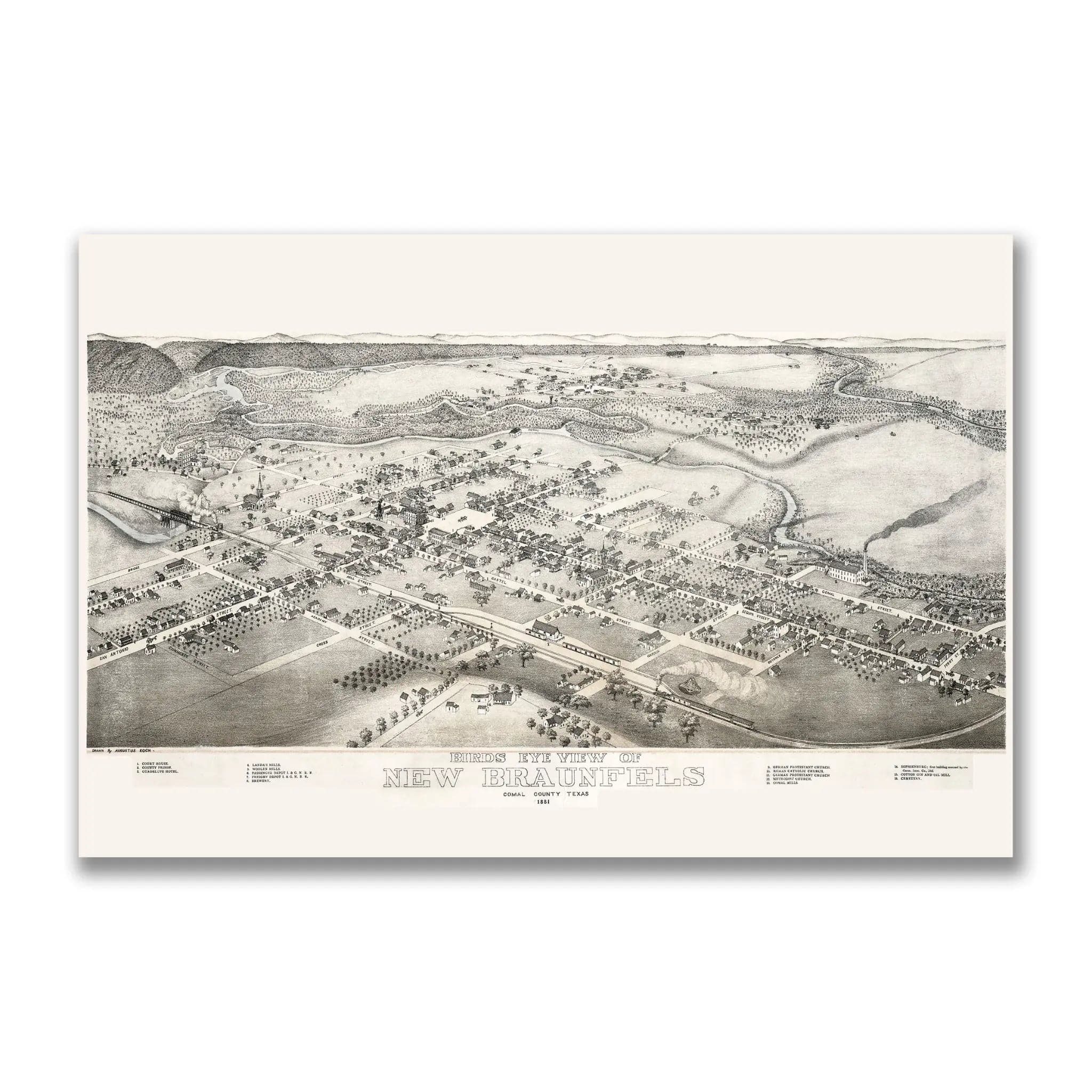
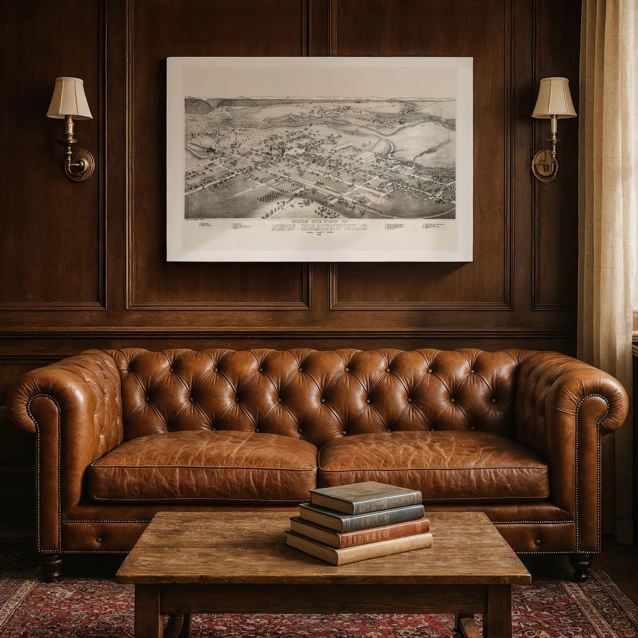
Step back into 1881 Texas with this extraordinary Bird's-Eye View of New Braunfels by Augustus Koch. This remarkable panoramic map captures the town at a pivotal moment when it had grown from a German-immigrant settlement into a burgeoning community of commerce, faith, and civic ambition. Every street, building, and railroad track reflects a town where steam, rail, and local industry were knitting it more tightly to the future while preserving its unique cultural heritage.
Historical Significance
By 1881, New Braunfels had established itself as a vital link between German traditions and Texas progress. This meticulously detailed map documents the town during its transformation from frontier settlement to thriving commercial center. The railroad slices through town as the economic lifeline, bringing goods, people, and expectations while connecting this Hill Country community to broader markets. Steam engines carrying passengers and freight underscore the town's dual role as both a hub of local life and a gateway to opportunity.
Cartographic Excellence
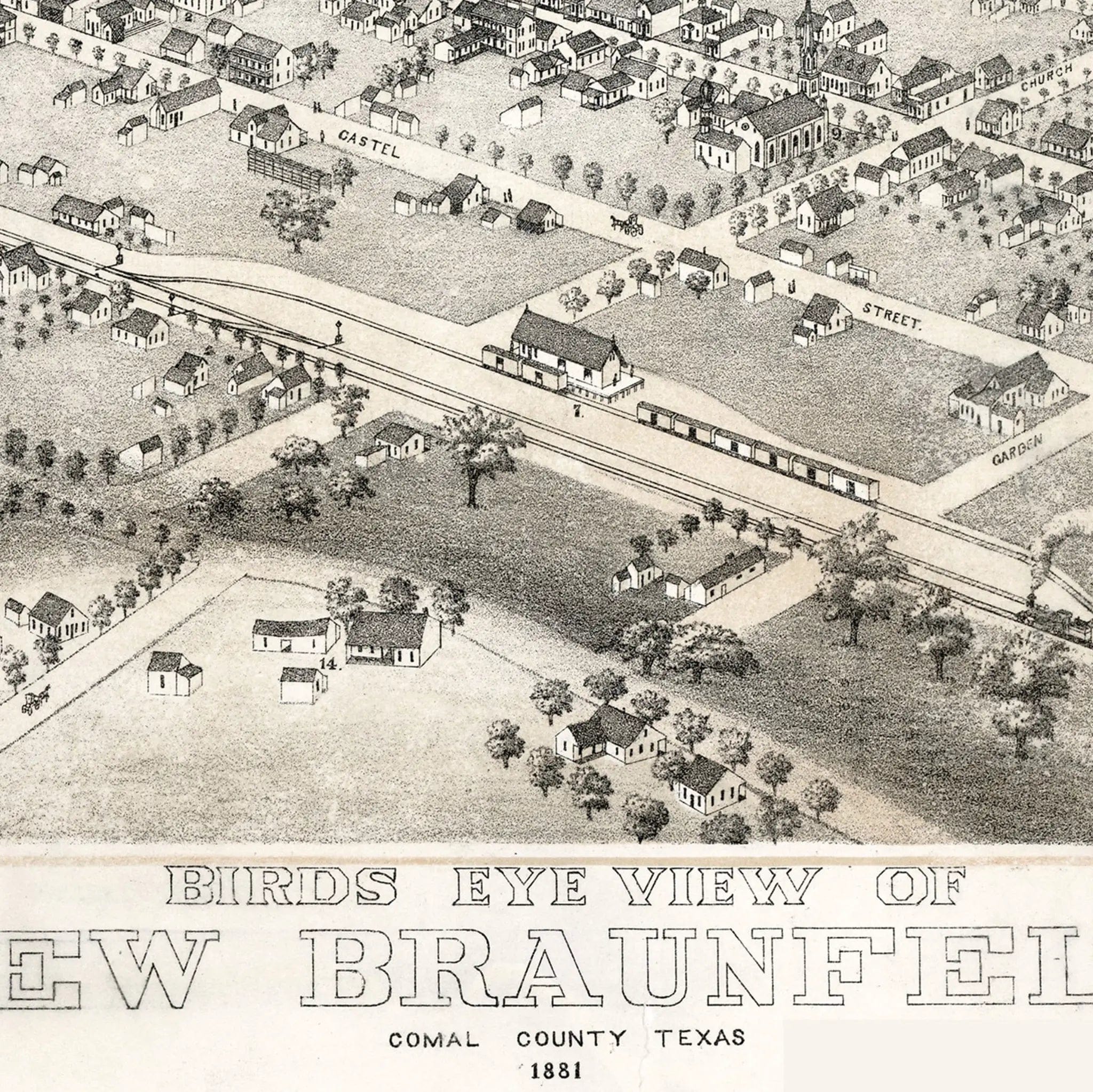
Augustus Koch's masterful bird's-eye perspective showcases New Braunfels with remarkable attention to civic pride and commercial potential. Religious, educational, and governmental structures are drawn with special emphasis—churches, the county courthouse, and schools signal order, faith, and investment in community institutions. These weren't afterthoughts but foundations, representing the solid monuments that guaranteed permanence in frontier Texas. The careful rendering of warehouses, hotels, depots, and shops near the railroad tracks forms the economic spine of this growing community.
Urban Development Story
The map presents a carefully planned grid of streets spreading outward from the central core, with buildings clustering near the railroad and river while farther lots remain open—evidence of a town still in progress yet confidently staking its claims. Beyond the built core, the land flows outward toward fields, orchards, and gentle hills, showing both natural constraints and unlimited opportunity. The soft topography allows growth in multiple directions, though slopes and ridges hint at the natural boundaries that would shape the town's expansion.
A Vision of Progress
This map serves as both historical record and act of persuasion. By emphasizing the denser core and railroad connections, highlighting important civic structures, and showing plenty of open lots, the map declares: invest here, build here, believe here. It asserts that New Braunfels deserves people, capital, and confidence. The composition shows not only a town on the map but a community actively making its mark on Texas history.
A Piece of Texas History
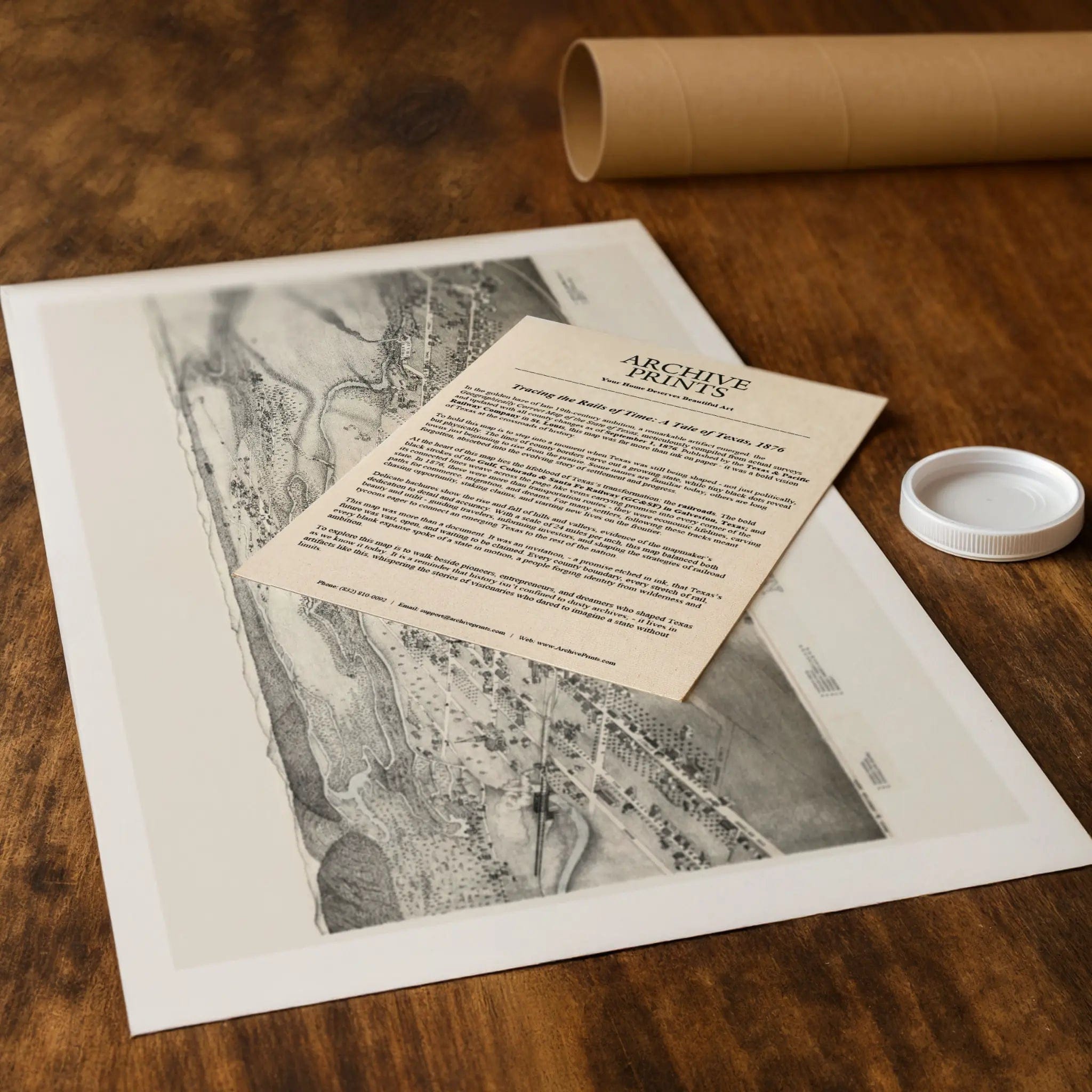
Each restored reproduction of this 1881 map is printed with museum-quality precision on heavyweight archival paper or hand-stretched premium canvas to preserve every original detail. Your purchase includes two companion documents:
Certificate of Authenticity verifying its restoration and reproduction quality
Historical Story Page detailing the origins, craftsmanship, and cultural significance of Koch's iconic map
Paper prints arrive rolled in reinforced mailing tubes for protection. Canvas prints come gallery-wrapped on solid pine stretcher bars with pre-installed hardware, ready to display upon arrival.
Bring home a vivid piece of Texas history—a timeless record of New Braunfels' German heritage and the vision that transformed a frontier settlement into one of Central Texas's most enduring communities.
The Map Story
By 1881, New Braunfels, Texas, had grown from a German‐immigrant settlement into a burgeoning town of commerce, faith, and civic ambition. This Bird’s-Eye View of New Braunfels captures the town at a moment when steam, rail, and local industry were knitting it more tightly to the future.
Seen from high over the valley, the map presents a grid of streets spreading outward from the central core. Buildings cluster near the railroad and river, while farther lots remain open—a town still in progress, and yet staking its claims. Smoke rises from mills and cotton gins, trains puff along tracks, churches stand tall, and civic buildings assert authority. The map does not merely record what exists—it advertises what New Braunfels wants to become.
The railroad is central to the composition. Tracks slice through town, bringing in goods, people, and expectation. The inclusion of steam engines—one carrying passengers, another laden with freight—underscores the town’s dual role as a hub of local life and a link to broader markets. Near the tracks, warehouses, hotels, depots, and shops press together, forming the economic spine of the community.
Religious, educational, and governmental structures are drawn with emphasis. Churches, the county courthouse, schools—they signal order, faith, and investment in community institutions. These are not afterthoughts but foundations: in a frontier land, seen and solid monuments guarantee permanence.
Beyond the built core, the land loosens. Fields, orchards, fences, hills—they all flow outward toward the horizon, evidence of both constraint and opportunity. The edges are not rigid walls; they invite extension. The topography is soft, allowing growth in many directions, though slopes and ridges hint at natural boundaries.
This map is also an act of persuasion. By accentuating the denser core and the tracks, by highlighting important structures, and by leaving plenty of open lots, the map says: invest here, build here, believe here. It asserts that New Braunfels deserves people, capital, and confidence.
Today, the 1881 view endures as a visual bridge between settlement and city. In its lines one sees both the careful planner and the hopeful dreamer. The map shows not only a town on the map, but a town making its map.
Materials
Choose options

Because every place has a story
Make History Personal
A vintage map is more than art.
It is a reminder of where life began.
Where memories were made.
Where hearts still live. Give the gift of place.
Beautifully preserved and made for the moments that matter.
Why Choose Us?
| Feature | Us | Competitor A | Competitor B |
|---|---|---|---|
| Hand Crafted | |||
| Museum Quality | |||
| 100 Year Guarantee | |||
| Restored by Hand | |||
| Certificate of Authenticity |

Art Prints
Archival quality colors. Best option if you'd like to frame it yourself

The Best Materials
We hand-stretched our canvas on solid American-grown pine stretcher bars. We use quality canvas and fade-resistant inks to create the lasting art. Canvases come with hardware already installed and ready to hang.
Need help?
Frequently Asked Questions
Order
All of our maps are meticulously restored reproductions of historic originals. Each piece is digitally repaired and color-corrected to bring out the finest details while preserving its authentic, vintage character.
Yes. All Archive Prints products are printed to order in the USA with archival materials.
We offer two premium formats:
- High-Quality Paper Posters – Printed on thick, archival-grade matte paper for rich, vibrant detail.
- Hand-Stretched Canvas Prints – Printed on premium polycotton canvas and mounted on 1.5" solid American pine stretcher bars for a gallery-quality finish.
We carefully digitally restore each map to enhance clarity and color while preserving its original look and historic charm. You’ll enjoy sharp details and a timeless vintage aesthetic that feels true to the original piece.
Yes, we do! We offer premium framing options to make your map ready to hang the moment it arrives. You can choose from Oak, Maple, Black, or Walnut frames directly on the product page. We also offer Stretched Canvas prints for a modern gallery look, as well as archival-quality Posters if you prefer to frame it yourself.
Yes! We offer free shipping on all products within the United States. Each map is carefully packaged to ensure it arrives in perfect condition.
If you’re not completely satisfied, you can return your order in new condition for a full refund. Return shipping costs are the responsibility of the customer.
Absolutely! Our maps make thoughtful, one-of-a-kind gifts for history lovers, map collectors, or anyone looking to add vintage character to their home or office. Choose between paper prints for framing or stretched canvas for a ready-to-hang presentation.
- Paper Posters → Shipped in durable, protective tubes to prevent creasing.
- Canvas Prints → Carefully wrapped, padded, and boxed to ensure safe delivery.
Our maps look stunning in a variety of settings, including:
- Living rooms and home offices
- Libraries and studies
- Corporate offices and conference rooms
- Restaurants, cafes, and boutique spaces