New York City Map - Vintage 1877 Citizens' & Travelers' Guide Map for Collectors
Discover Manhattan's Golden Age
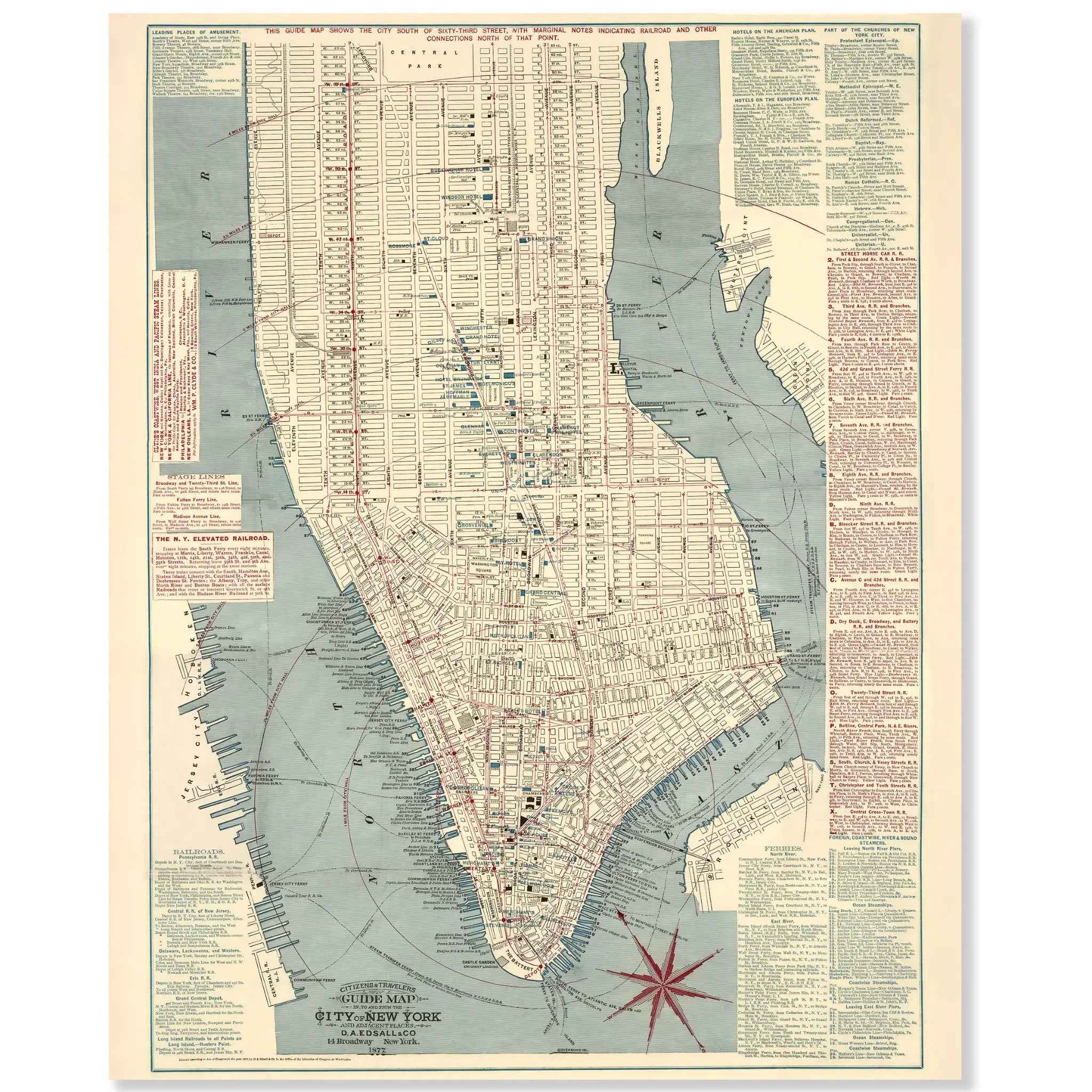
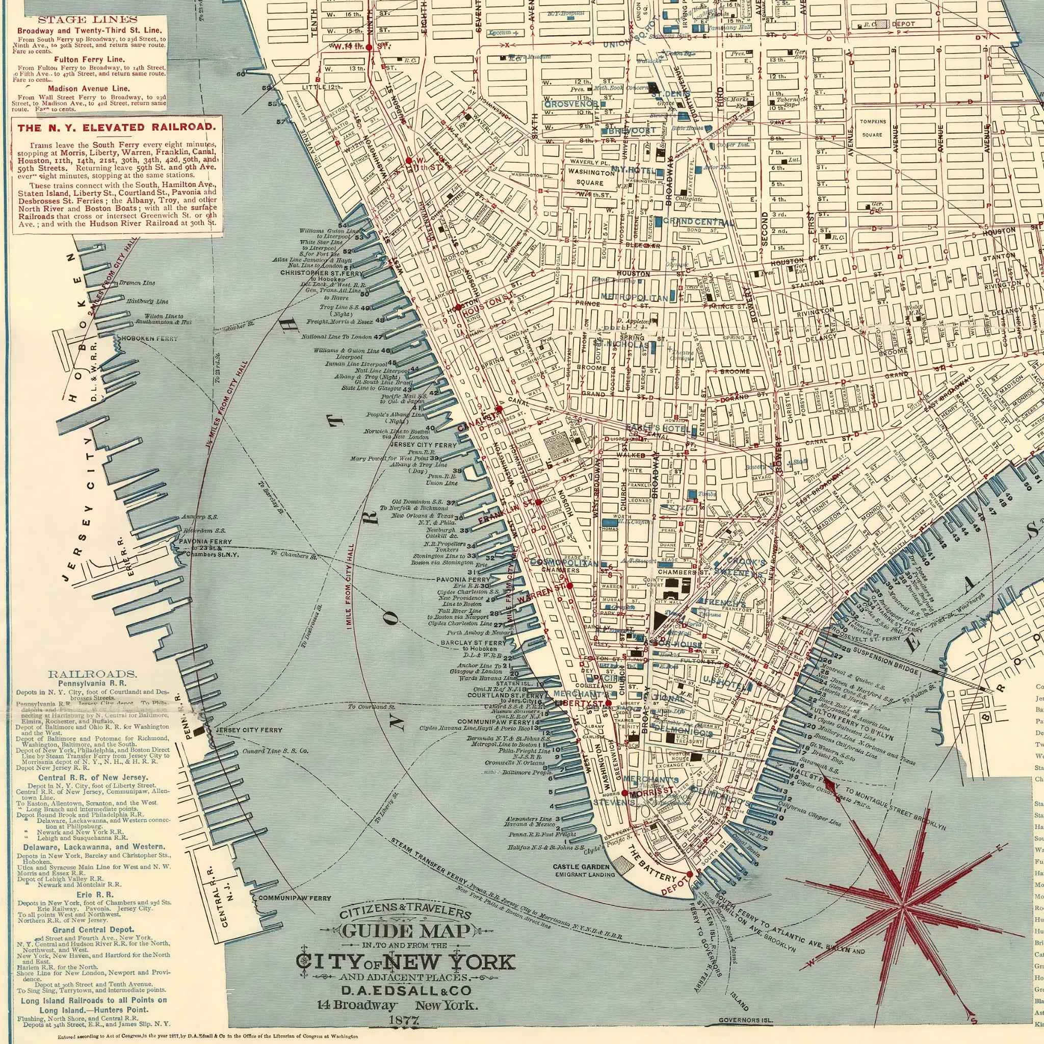
Step into the bustling world of 1877 New York City with this extraordinary Citizens' & Travelers' Guide Map that captures Manhattan during one of its most transformative periods in American urban history. Published by D.A. Edsall & Co., this meticulously detailed cartographic masterpiece reveals the city as it stood on the brink of becoming the world's greatest metropolis, when horse-drawn carriages shared cobblestone streets with the first elevated railways and magnificent steamships crowded the harbor.
Historical Significance
In 1877, New York City was experiencing unprecedented growth and modernization that would define the American urban experience for generations to come. This comprehensive guide map documents Manhattan during the Gilded Age boom, when the city was rapidly expanding northward beyond 42nd Street, the Brooklyn Bridge was under construction, and waves of immigrants were transforming neighborhoods from the Lower East Side to Harlem. The map showcases not just streets and buildings, but the complex transportation network of ferries, elevated railways, and horse-drawn omnibus lines that connected Manhattan to Brooklyn, Queens, and New Jersey, making it the commercial and cultural heart of America.
Cartographic Excellence
This masterful guide map represents the pinnacle of 19th-century urban cartography, combining practical navigation with comprehensive reference information. The detailed rendering reveals Manhattan's street grid with remarkable precision, from the narrow, winding lanes of lower Manhattan that followed old Dutch cow paths to the orderly numbered streets of the expanding uptown districts. Extensive marginal text provides ferry schedules, railroad timetables, and detailed descriptions of stage lines, creating a complete transportation guide for residents and visitors navigating the rapidly changing city.
Urban Development Story
Within the carefully mapped streets and waterways, the story of America's greatest urban transformation unfolds through detailed illustrations of ferry terminals, railroad depots, and the emerging elevated railway system. The map captures Manhattan at a crucial moment when traditional transportation methods were giving way to modern urban transit, featuring everything from the Fulton Ferry connecting to Brooklyn to the pioneering elevated railway lines that would revolutionize city travel. The comprehensive coverage of adjacent areas in Brooklyn, Queens, and New Jersey reflects the growing interconnectedness of the greater New York region.
Metropolitan Heritage
Beyond its function as a practical guide, this map represents the ambition and energy that made New York City the symbol of American opportunity and innovation. The careful documentation of transportation networks, commercial districts, and emerging neighborhoods reveals how the city was designed to accommodate both established residents and the constant flow of newcomers seeking their fortune. The presence of detailed ferry schedules and railroad connections captures the dynamic movement of people and goods that made Manhattan the economic engine of the nation.
This detailed cartographic record preserves New York City at a moment of tremendous growth and optimism—when the foundations were being laid for the modern metropolis that would become the world's most influential city. The map captures the essence of a community that valued both tradition and progress, creating the unique energy and diversity that defines New York to this day. Perfect for New York history enthusiasts, urban planning aficionados, and collectors of vintage city maps, this restored guide serves as both a historical treasure and a stunning piece of wall art that celebrates the vision and determination that built America's greatest city.
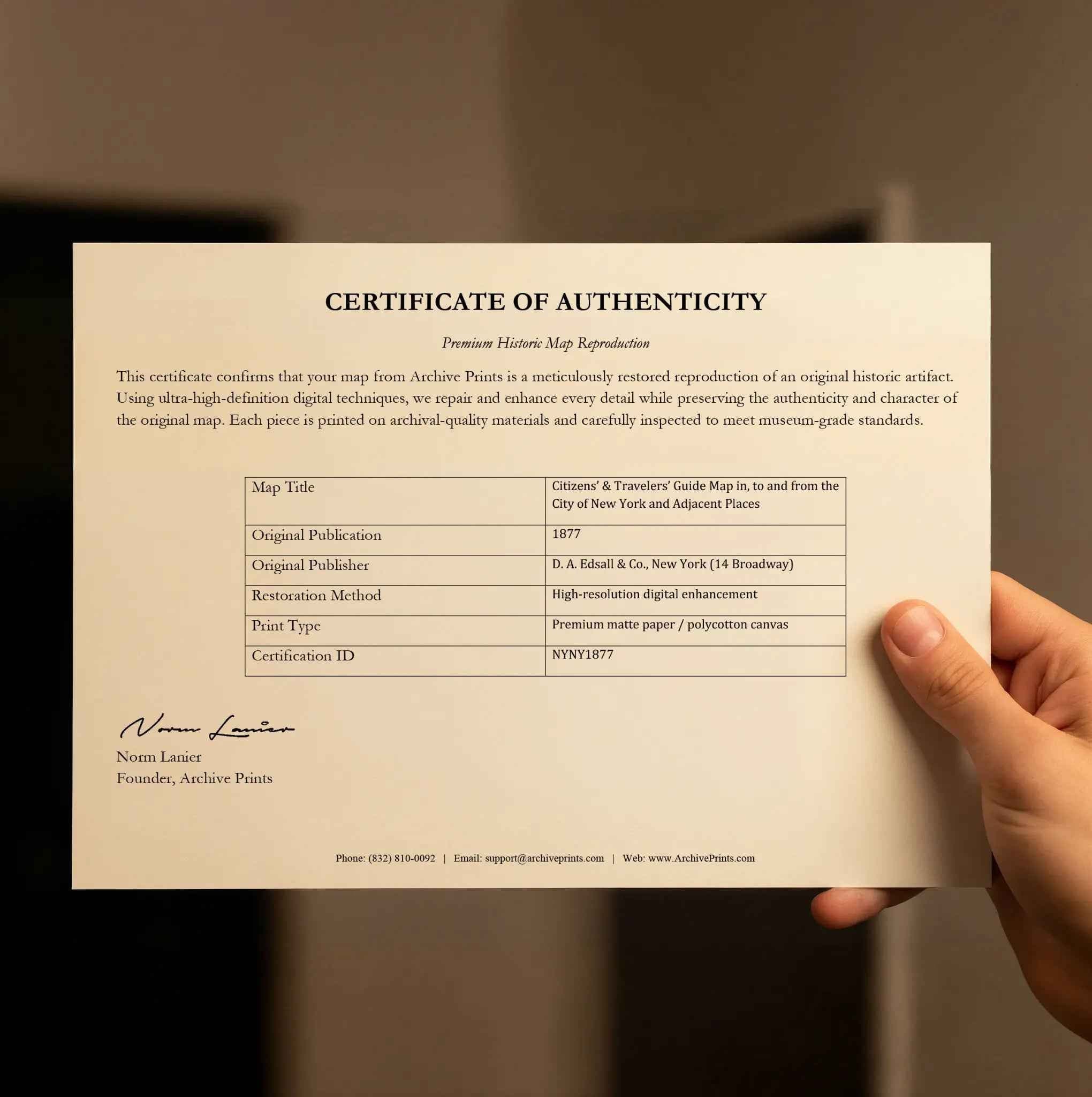
Each reproduction includes a custom historical letter detailing New York City's role in 19th-century American urban development and the transportation innovations that connected Manhattan to the growing metropolitan region. Printed on heavyweight archival paper or premium canvas, every street, ferry route, and railroad line is preserved with museum-quality clarity through expert digital restoration.
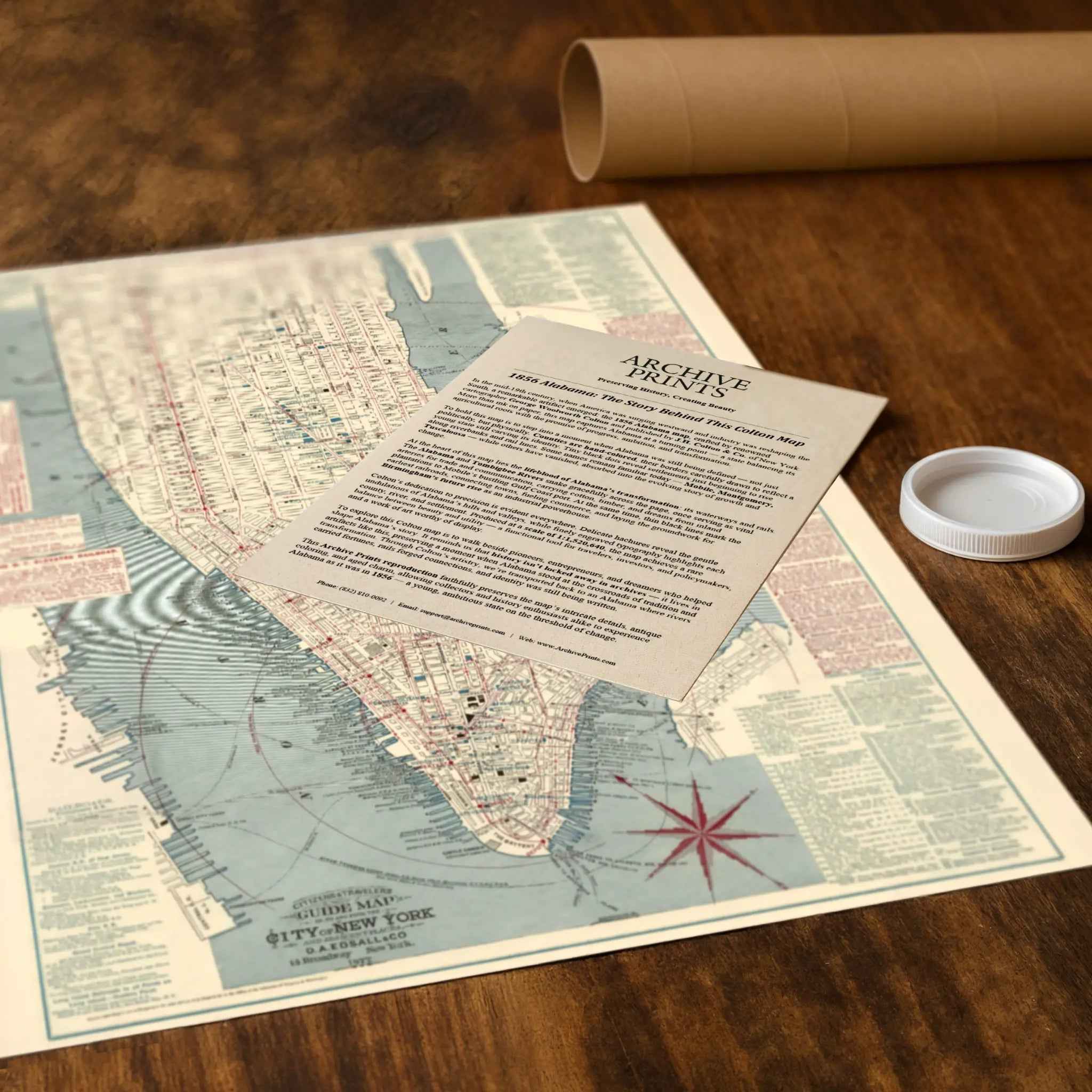
For protection and presentation, paper prints arrive rolled in sturdy mailing tubes, while canvas prints come gallery-wrapped on solid pine stretcher bars with pre-installed hanging hardware—ready to display immediately.
Bring home a piece of New York history with this captivating glimpse into Manhattan during the Gilded Age transformation that created the world's greatest city.
The Map Story
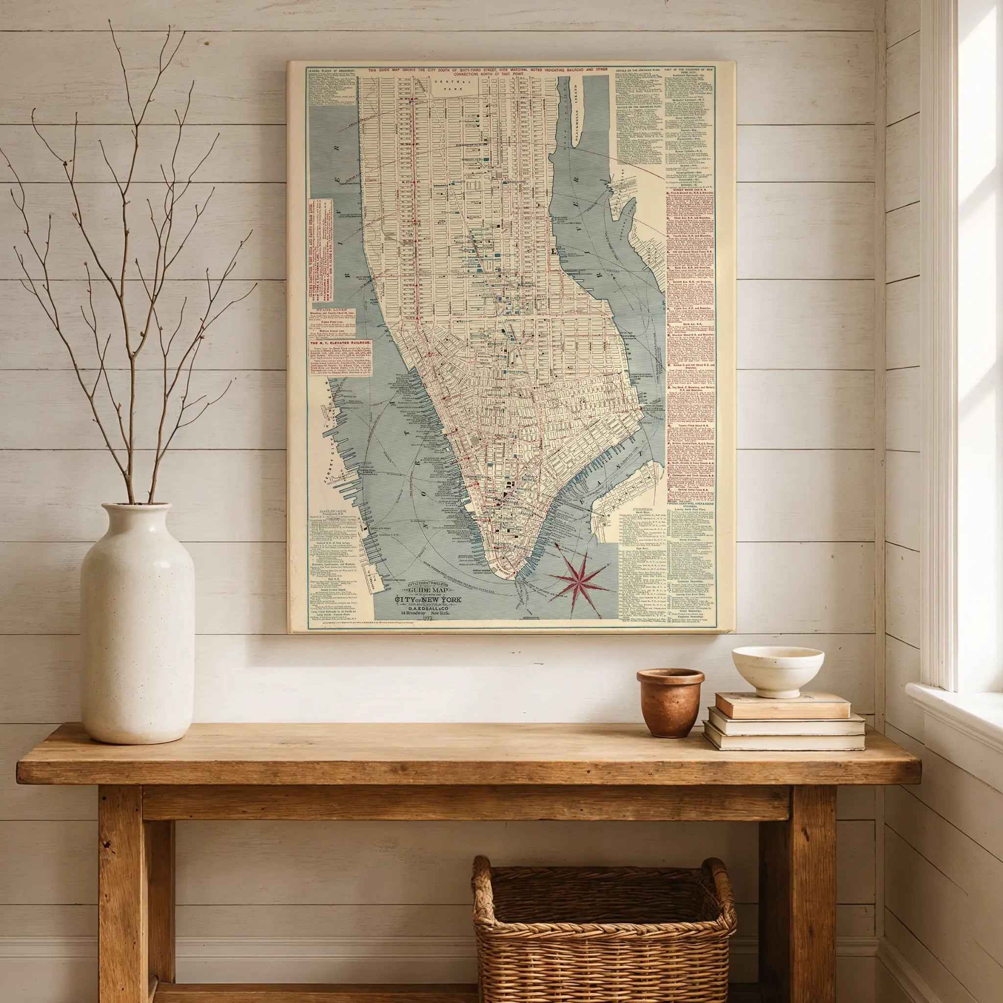
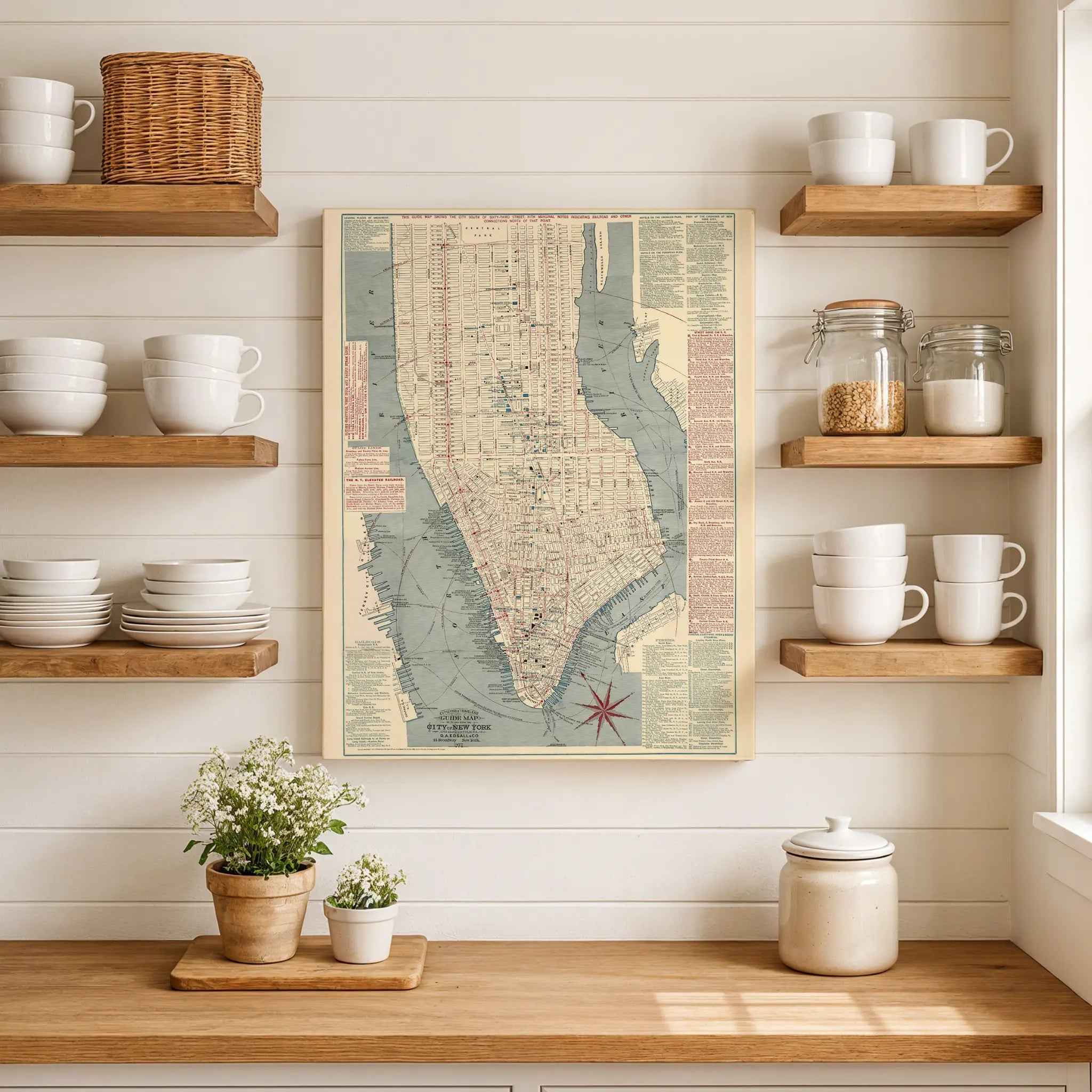
In 1877 D. A. Edsall & Co. issued the pocket “Citizens’ & Travelers’ Guide Map in, to and from the City of New York and Adjacent Places,” a color-printed folding plan that captures Manhattan south of 63rd Street at the high tide of the horsecar and early elevated-rail era. Designed to be carried, consulted, and advertised upon, it pairs a dense street plan with practical wayfinding—ferry landings, rail depots, horsecar routes, and the new iron “els” that were beginning to lift commuters above the traffic of Broadway and the Bowery.
The map’s legend explains its vivid palette. Red traces street railways and the elevated lines; blue picks out hotels, theaters, and prominent stores; black identifies public buildings and churches. The result is a quick visual code for travelers moving between steamboat piers, rail terminals, and places of lodging or amusement. Lists in the margins expand on these themes with ferry connections to Brooklyn, Queens, Staten Island, and New Jersey, as well as steamship lines and stage routes that bound New York to the wider world.
Edsall’s plan also reflects the commercial ecosystem that produced it. Copies were presented by the Adams Express Company, one of the nineteenth century’s major freight and parcel firms, whose north–south corridors connected New York’s waterfront to the national rail network. By highlighting depots, warehouses, and piers alongside civic landmarks, the map reads as both a visitor’s guide and a logistics diagram for a metropolis powered by ferries, rails, and the river.
Geographically, the sheet centers Lower Manhattan and the business districts fanning out from City Hall and the Battery. Radial distance marks from City Hall help gauge walks and rides. Broadway cuts its famous diagonal through the numbered grid, while Central Park, only partly shown at the northern edge, anchors the city’s developing uptown. Across the rivers, the cartography reaches to Hunter’s Point, Greenpoint, and Brooklyn, underscoring daily cross-river travel before the dominance of bridges and tunnels.
Seen today, the 1877 Edsall guide map preserves New York in motion—between the age of horse-drawn cars and the coming subway, between island-bound neighborhoods and an emerging regional system. It is utilitarian and promotional at once, a bright, portable portrait of how people actually navigated the great metropolis of the late nineteenth century.
Materials
Hand‑Stretched Canvas: If you choose canvas, we use a premium cotton‑poly blend stretched over solid pine frames. Each canvas is carefully hand‑stretched for a tight, gallery‑quality finish that's ready to hang right out of the box.
Vivid, Fade‑Resistant Inks: We use professional‑grade inks that are UV‑resistant, so your print retains its rich colors even when displayed in bright rooms.
Expert Restoration: Every map is digitally restored by skilled artisans. We preserve the character of the original while enhancing clarity, so you see the map as it was meant to be seen.
Secure Packaging: Paper prints are rolled in heavy‑duty mailing tubes, and canvases are cushioned in reinforced boxes to ensure they arrive in pristine condition.
Choosing one of our prints means investing in craftsmanship. We combine historical authenticity with modern print technology and premium materials, giving you a work of art built to stand the test of time.
Choose options

Because every place has a story
Make History Personal
A vintage map is more than art.
It is a reminder of where life began.
Where memories were made.
Where hearts still live. Give the gift of place.
Beautifully preserved and made for the moments that matter.
Why Choose Us?
| Feature | Us | Competitor A | Competitor B |
|---|---|---|---|
| Hand Crafted | |||
| Museum Quality | |||
| 100 Year Guarantee | |||
| Restored by Hand | |||
| Certificate of Authenticity |

Art Prints
Archival quality colors. Best option if you'd like to frame it yourself

The Best Materials
We hand-stretched our canvas on solid American-grown pine stretcher bars. We use quality canvas and fade-resistant inks to create the lasting art. Canvases come with hardware already installed and ready to hang.
Need help?
Frequently Asked Questions
Order
All of our maps are meticulously restored reproductions of historic originals. Each piece is digitally repaired and color-corrected to bring out the finest details while preserving its authentic, vintage character.
Yes. All Archive Prints products are printed to order in the USA with archival materials.
We offer two premium formats:
- High-Quality Paper Posters – Printed on thick, archival-grade matte paper for rich, vibrant detail.
- Hand-Stretched Canvas Prints – Printed on premium polycotton canvas and mounted on 1.5" solid American pine stretcher bars for a gallery-quality finish.
We carefully digitally restore each map to enhance clarity and color while preserving its original look and historic charm. You’ll enjoy sharp details and a timeless vintage aesthetic that feels true to the original piece.
Yes, we do! We offer premium framing options to make your map ready to hang the moment it arrives. You can choose from Oak, Maple, Black, or Walnut frames directly on the product page. We also offer Stretched Canvas prints for a modern gallery look, as well as archival-quality Posters if you prefer to frame it yourself.
Yes! We offer free shipping on all products within the United States. Each map is carefully packaged to ensure it arrives in perfect condition.
If you’re not completely satisfied, you can return your order in new condition for a full refund. Return shipping costs are the responsibility of the customer.
Absolutely! Our maps make thoughtful, one-of-a-kind gifts for history lovers, map collectors, or anyone looking to add vintage character to their home or office. Choose between paper prints for framing or stretched canvas for a ready-to-hang presentation.
- Paper Posters → Shipped in durable, protective tubes to prevent creasing.
- Canvas Prints → Carefully wrapped, padded, and boxed to ensure safe delivery.
Our maps look stunning in a variety of settings, including:
- Living rooms and home offices
- Libraries and studies
- Corporate offices and conference rooms
- Restaurants, cafes, and boutique spaces