Oklahoma & Indian Territory Map 1905
Oklahoma & Indian Territory Map 1905
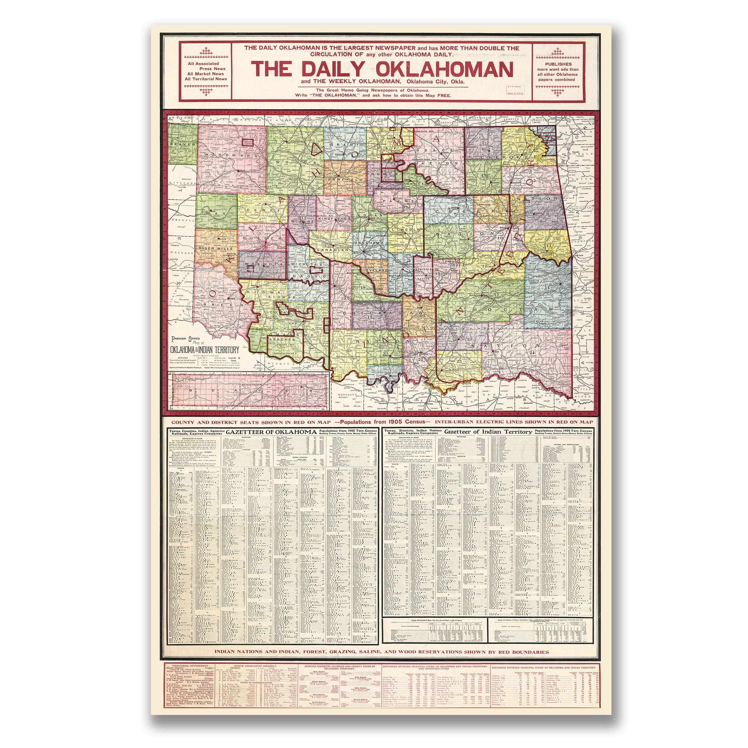
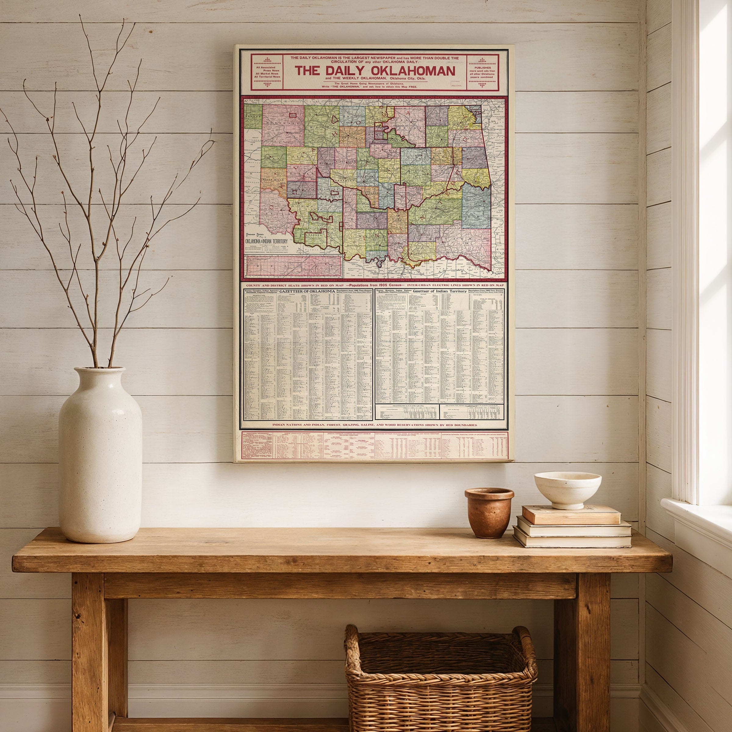
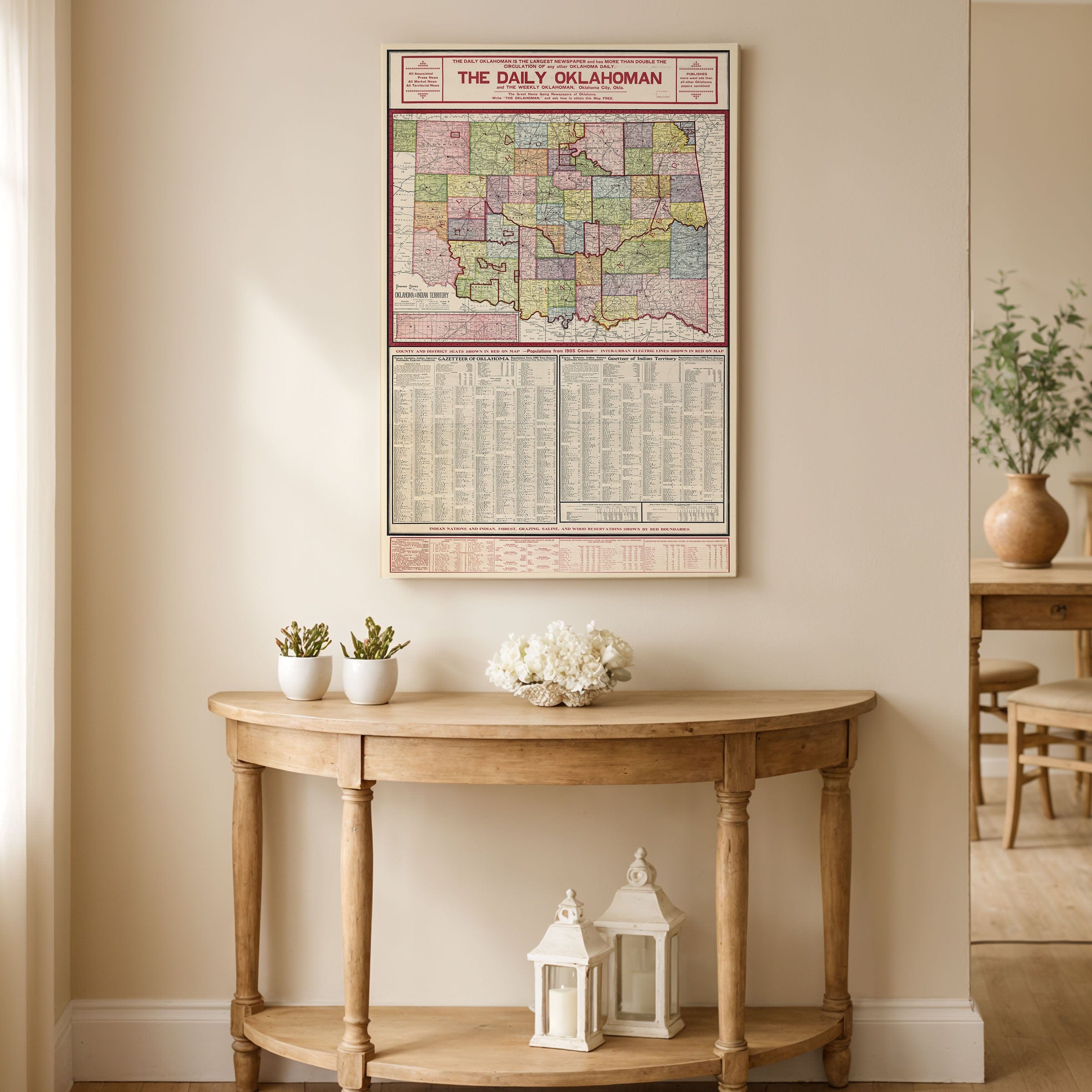
Discover the historic Oklahoma & Indian Territory Map published by The Daily Oklahoman, capturing the lands just two years before statehood at a moment of intense transition—two neighboring territories, each with its own legal systems, settlement patterns, and histories, moving steadily toward unification. This Premier Series map offers both a practical guide and a vivid snapshot of a region on the threshold of dramatic change that would create the 46th state.
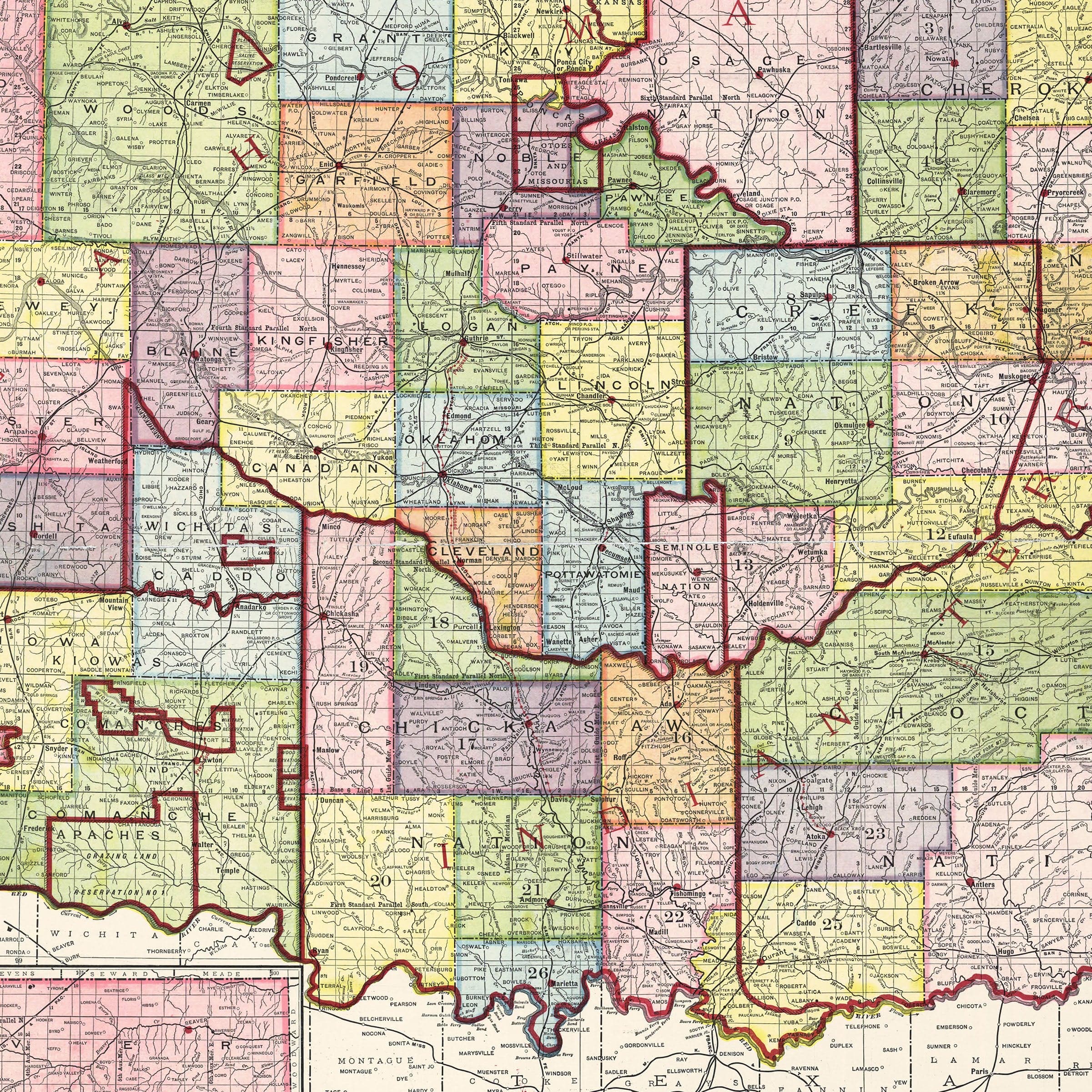
Across this Oklahoma & Indian Territory Map, Oklahoma Territory and Indian Territory are depicted side-by-side, their county and district boundaries sharply defined in contrasting colors. The effect is striking: a patchwork of jurisdictions that reflects decades of shifting federal policy, tribal governance, land runs, and settler expansion. County seats are highlighted in red, emphasizing the emerging civic centers that would soon anchor the new state's government and economy. The map's extensive gazetteer lists towns, post offices, agencies, and populations recorded in the 1905 territorial census.
This wealth of information in the Oklahoma & Indian Territory Map underscores the region's explosive growth. Dozens of new communities had sprung up within a single generation, fueled by railroads, land lotteries, and the promise of opportunity on what boosters called the last frontier. Interurban electric rail lines, also shown in red, reveal a modernizing transportation network connecting towns across the prairies. Indian Territory, occupying the map's eastern half, reflects the sovereign nations whose lands had been divided into districts under the laws of the Five Tribes.
The names shown in this Oklahoma & Indian Territory Map—Choctaw, Chickasaw, Creek, Cherokee, and Seminole—remain deeply visible on the landscape. Yet the enclosing red boundaries of forest, grazing, and reservation lands hint at federal pressure, allotment policies, and the gradual erosion of tribal autonomy in the years leading to statehood. Inset maps and reference tables reinforce the practical purpose of the publication: to serve settlers, merchants, and policymakers navigating a rapidly changing region.
Perfect for Oklahoma residents, Native American history enthusiasts, and collectors of territorial cartography, this Oklahoma & Indian Territory Map reproduction includes a custom historical certificate. The twin territories of 1905 were places of cultural collision and adaptation, where Native nations, African American freedmen communities, European-American settlers, and immigrants shaped towns and economies together. Printed on heavyweight archival paper or hand-stretched polycotton canvas, every county, district, town, and rail line is restored in museum-grade clarity for generations of enjoyment. Paper prints ship rolled in heavy-duty tubes, while canvas editions arrive gallery-wrapped on solid pine stretcher bars with pre-installed hardware—ready to display the moment it arrives. Bring home a piece of Oklahoma history and celebrate the complex mosaic that formed the foundation of the 46th state.
The Map Story
Materials
Choose options

Because every place has a story
Make History Personal
A vintage map is more than art.
It is a reminder of where life began.
Where memories were made.
Where hearts still live. Give the gift of place.
Beautifully preserved and made for the moments that matter.
Why Choose Us?
| Feature | Us | Competitor A | Competitor B |
|---|---|---|---|
| Hand Crafted | |||
| Museum Quality | |||
| 100 Year Guarantee | |||
| Restored by Hand | |||
| Certificate of Authenticity |

Art Prints
Archival quality colors. Best option if you'd like to frame it yourself

The Best Materials
We hand-stretched our canvas on solid American-grown pine stretcher bars. We use quality canvas and fade-resistant inks to create the lasting art. Canvases come with hardware already installed and ready to hang.
Need help?
Frequently Asked Questions
Order
All of our maps are meticulously restored reproductions of historic originals. Each piece is digitally repaired and color-corrected to bring out the finest details while preserving its authentic, vintage character.
Yes. All Archive Prints products are printed to order in the USA with archival materials.
We offer two premium formats:
- High-Quality Paper Posters – Printed on thick, archival-grade matte paper for rich, vibrant detail.
- Hand-Stretched Canvas Prints – Printed on premium polycotton canvas and mounted on 1.5" solid American pine stretcher bars for a gallery-quality finish.
We carefully digitally restore each map to enhance clarity and color while preserving its original look and historic charm. You’ll enjoy sharp details and a timeless vintage aesthetic that feels true to the original piece.
Yes, we do! We offer premium framing options to make your map ready to hang the moment it arrives. You can choose from Oak, Maple, Black, or Walnut frames directly on the product page. We also offer Stretched Canvas prints for a modern gallery look, as well as archival-quality Posters if you prefer to frame it yourself.
Yes! We offer free shipping on all products within the United States. Each map is carefully packaged to ensure it arrives in perfect condition.
If you’re not completely satisfied, you can return your order in new condition for a full refund. Return shipping costs are the responsibility of the customer.
Absolutely! Our maps make thoughtful, one-of-a-kind gifts for history lovers, map collectors, or anyone looking to add vintage character to their home or office. Choose between paper prints for framing or stretched canvas for a ready-to-hang presentation.
- Paper Posters → Shipped in durable, protective tubes to prevent creasing.
- Canvas Prints → Carefully wrapped, padded, and boxed to ensure safe delivery.
Our maps look stunning in a variety of settings, including:
- Living rooms and home offices
- Libraries and studies
- Corporate offices and conference rooms
- Restaurants, cafes, and boutique spaces