
Pensacola, Florida Map - 1885 Bird's-Eye View Historic Gulf Coast Map
Pensacola, Florida Map
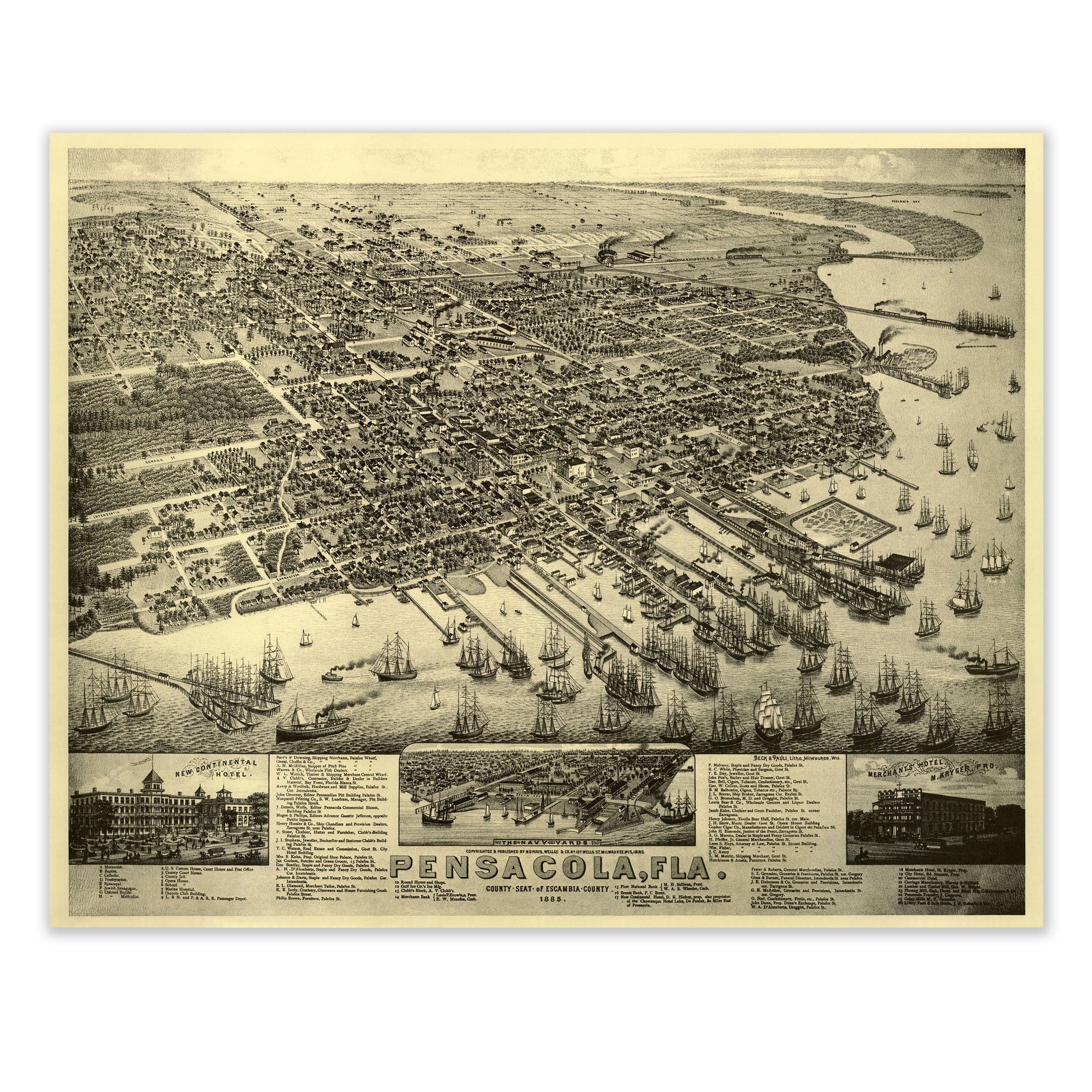
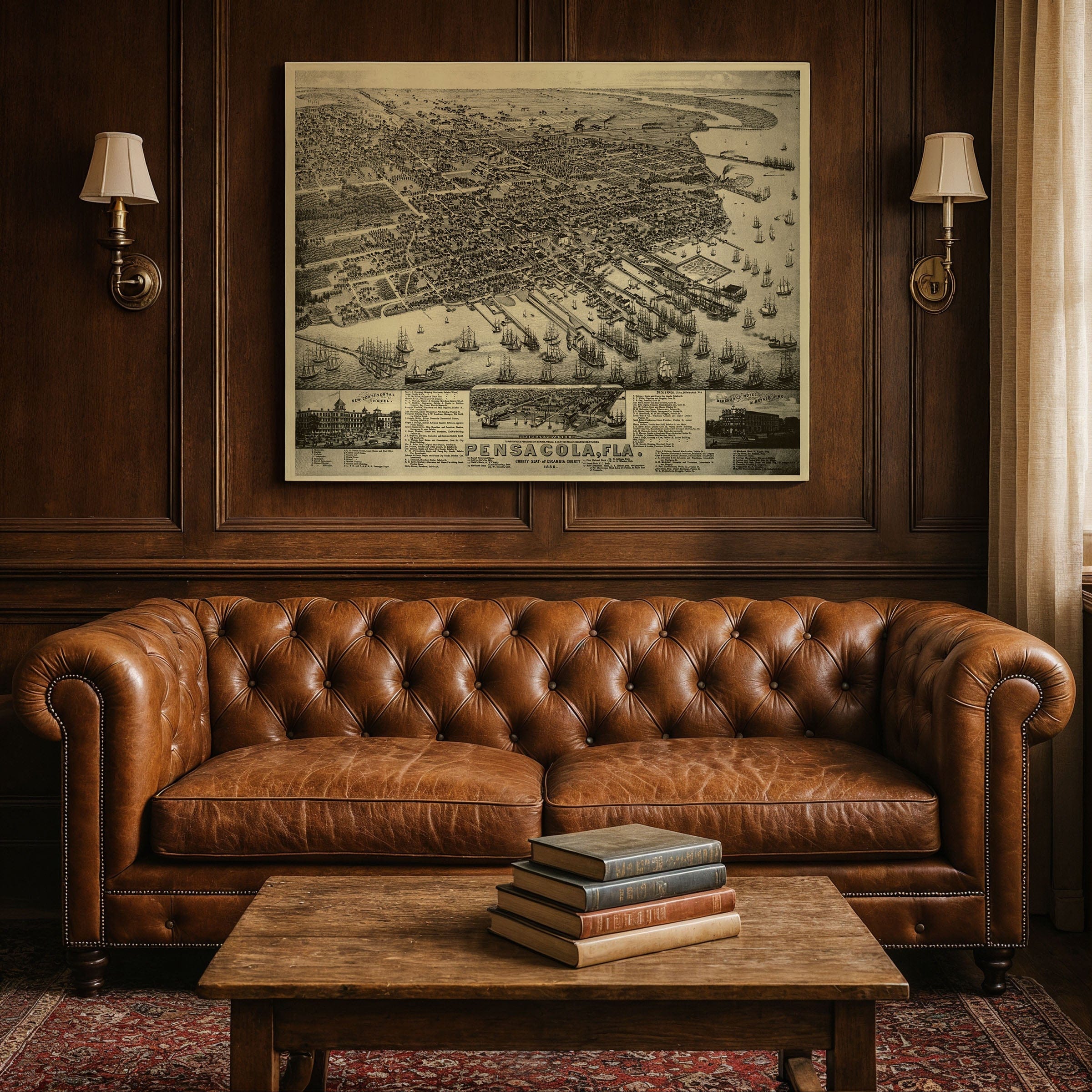
Step back to 1885 when this Pensacola, Florida map captured the thriving seaport at the height of its 19th-century prosperity. This isn't just geography—it's a portrait of maritime ambition and Gulf Coast commerce, published by N. Currier & Co. and drawn by Beck & Pauli when Pensacola stood as one of the South's most important harbors. Known as the City of Five Flags, Pensacola's deep natural harbor made it a gateway between the Gulf and the wider world, and this stunning bird's-eye lithograph reveals a city alive with commerce, industry, and promise. Dozens of ships—schooners, steamers, and coastal freighters—fill the harbor, their masts creating a forest of rigging along the waterfront. Each pier bustles with trade: lumber, naval stores, cotton, and seafood, all bound for distant ports across the Atlantic and the Caribbean. The wharves and warehouses stretch along the bay, connecting a bustling downtown laid out in precise gridlines that speak to Pensacola's early Spanish and British planning influences. The artist's elevated perspective provides an intricate glimpse into daily life. Streets bustle with horse-drawn carriages, pedestrians, and electric trolleys—symbols of a modernizing South. Landmarks like the New Continental Hotel and the Merchants Hotel stand proudly in the insets below, welcoming travelers and merchants alike. Churches, schools, foundries, and public halls are all labeled in the detailed legend, illustrating the civic pride of a city rebuilding and expanding after the Civil War. Beyond the urban center, neat rows of orange groves and pine forests stretch inland, emphasizing Florida's agricultural richness. The curving shoreline, dotted with shipyards and fisheries, highlights the maritime heritage that defined Pensacola's identity. Each reproduction includes a custom historical letter detailing the story behind the map, making it perfect for collectors, historians, and Florida enthusiasts. Printed on heavyweight archival paper or hand-stretched polycotton canvas, every ship, wharf, and building is restored in museum-grade clarity for generations of enjoyment. Paper prints ship rolled in heavy-duty tubes, while canvas editions arrive gallery-wrapped on solid pine stretcher bars with pre-installed hardware—ready to display the moment it arrives. Bring home a piece of Florida's maritime legacy and celebrate the port that connected the Gulf Coast to the world.
The Map Story
Materials
Choose options

Because every place has a story
Make History Personal
A vintage map is more than art.
It is a reminder of where life began.
Where memories were made.
Where hearts still live. Give the gift of place.
Beautifully preserved and made for the moments that matter.
Why Choose Us?
| Feature | Us | Competitor A | Competitor B |
|---|---|---|---|
| Hand Crafted | |||
| Museum Quality | |||
| 100 Year Guarantee | |||
| Restored by Hand | |||
| Certificate of Authenticity |

Art Prints
Archival quality colors. Best option if you'd like to frame it yourself

The Best Materials
We hand-stretched our canvas on solid American-grown pine stretcher bars. We use quality canvas and fade-resistant inks to create the lasting art. Canvases come with hardware already installed and ready to hang.
Need help?
Frequently Asked Questions
Order
All of our maps are meticulously restored reproductions of historic originals. Each piece is digitally repaired and color-corrected to bring out the finest details while preserving its authentic, vintage character.
Yes. All Archive Prints products are printed to order in the USA with archival materials.
We offer two premium formats:
- High-Quality Paper Posters – Printed on thick, archival-grade matte paper for rich, vibrant detail.
- Hand-Stretched Canvas Prints – Printed on premium polycotton canvas and mounted on 1.5" solid American pine stretcher bars for a gallery-quality finish.
We carefully digitally restore each map to enhance clarity and color while preserving its original look and historic charm. You’ll enjoy sharp details and a timeless vintage aesthetic that feels true to the original piece.
Yes, we do! We offer premium framing options to make your map ready to hang the moment it arrives. You can choose from Oak, Maple, Black, or Walnut frames directly on the product page. We also offer Stretched Canvas prints for a modern gallery look, as well as archival-quality Posters if you prefer to frame it yourself.
Yes! We offer free shipping on all products within the United States. Each map is carefully packaged to ensure it arrives in perfect condition.
If you’re not completely satisfied, you can return your order in new condition for a full refund. Return shipping costs are the responsibility of the customer.
Absolutely! Our maps make thoughtful, one-of-a-kind gifts for history lovers, map collectors, or anyone looking to add vintage character to their home or office. Choose between paper prints for framing or stretched canvas for a ready-to-hang presentation.
- Paper Posters → Shipped in durable, protective tubes to prevent creasing.
- Canvas Prints → Carefully wrapped, padded, and boxed to ensure safe delivery.
Our maps look stunning in a variety of settings, including:
- Living rooms and home offices
- Libraries and studies
- Corporate offices and conference rooms
- Restaurants, cafes, and boutique spaces