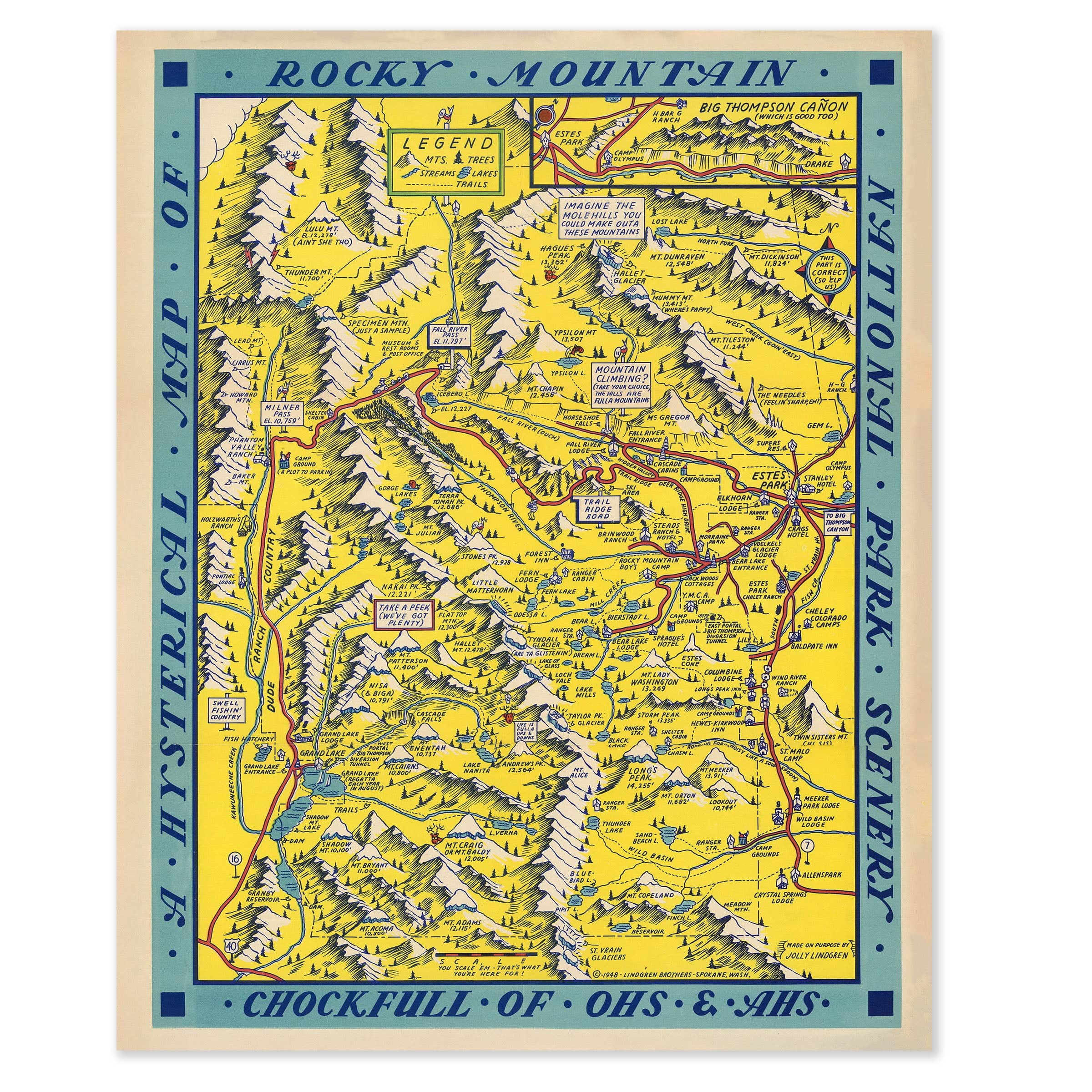
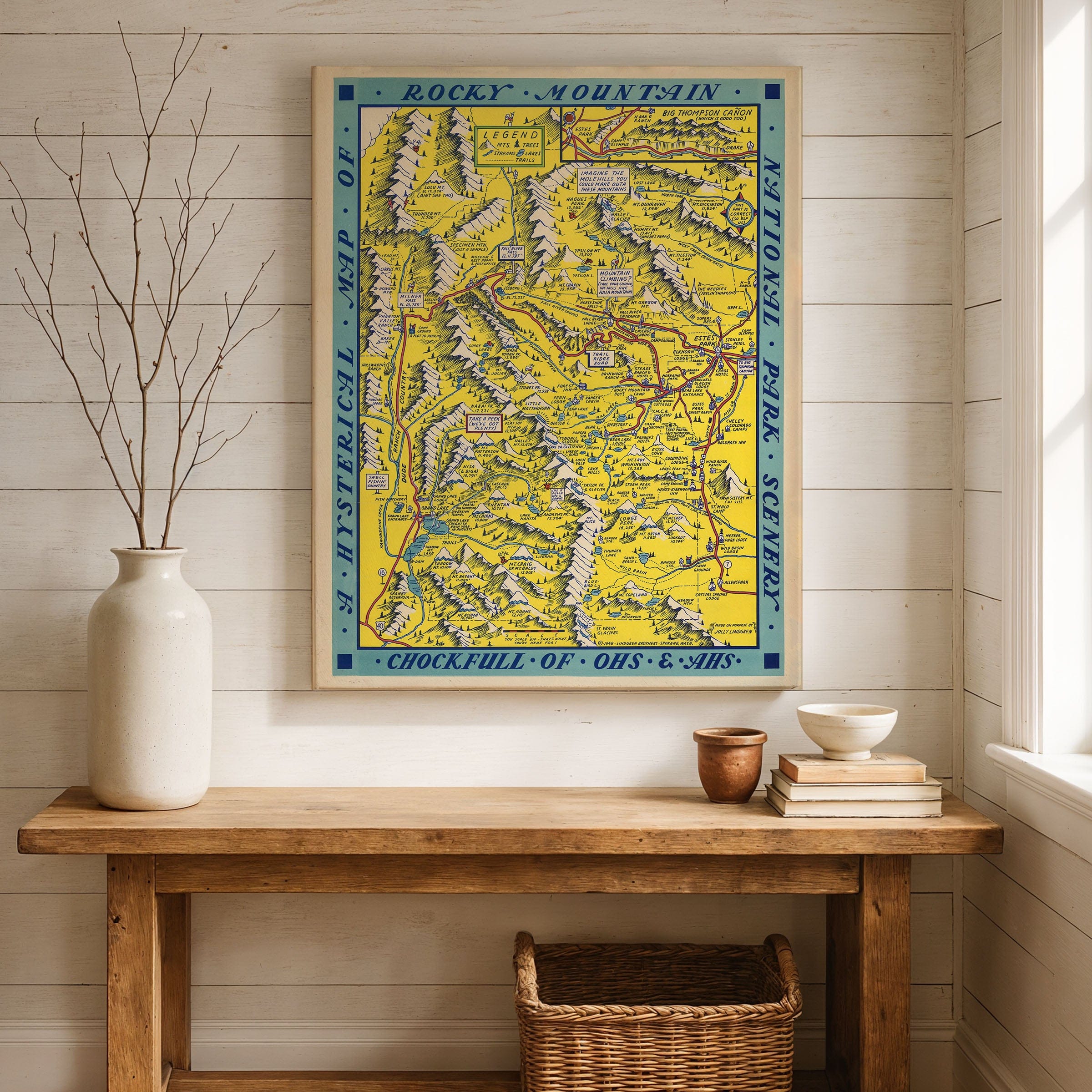
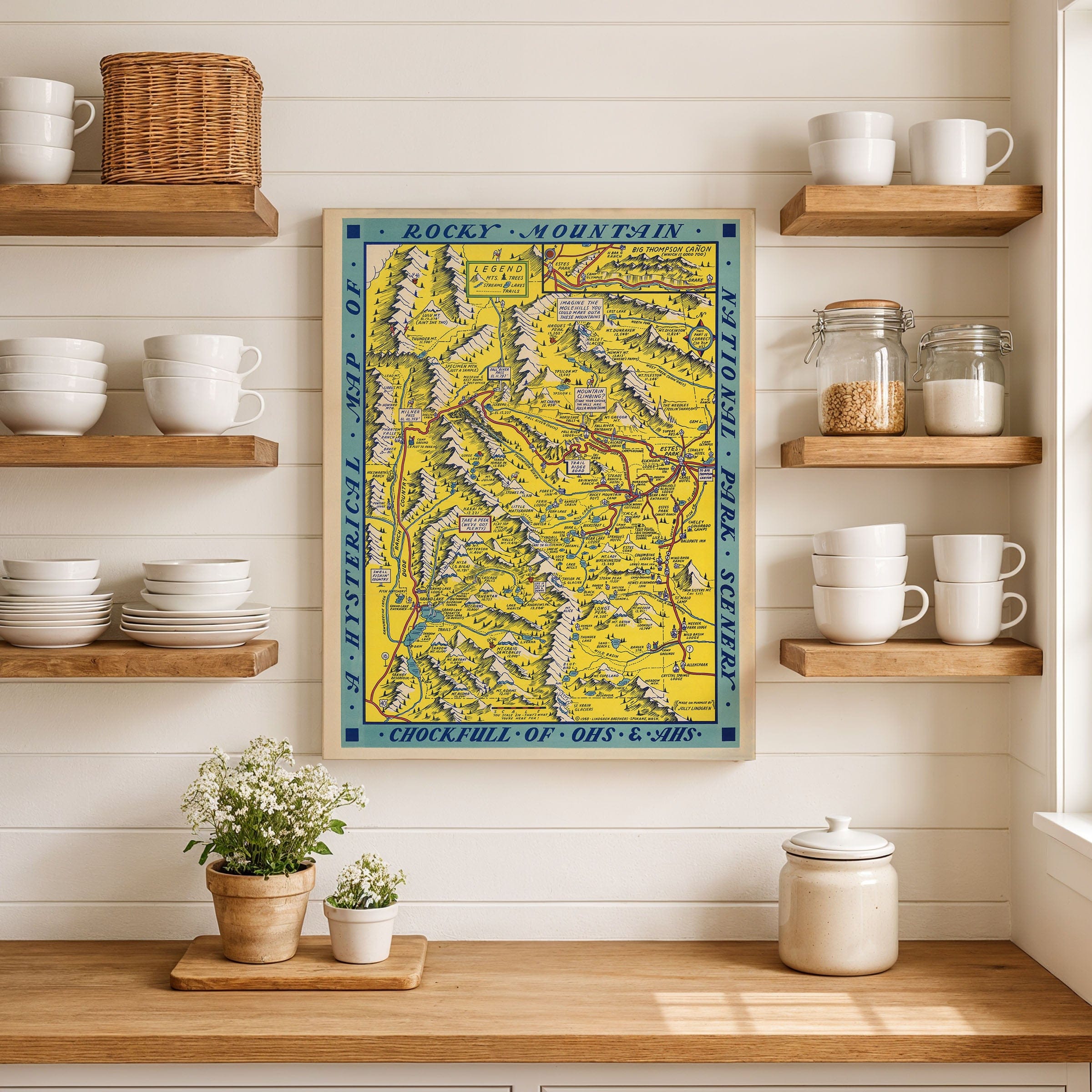
Hysterical Map of Rocky Mountain National Park 1948 - Jolly Lindgren Pictorial Map
Step into the golden age of American road trips with this whimsical 1948 masterpiece by Jolly Lindgren. A Hysterical Map of Rocky Mountain National Park Scenery, Chockfull of Ohs & Ahs isn't your typical navigation tool—it's a joyful celebration of postwar wanderlust, mountain grandeur, and the irresistible charm of discovering the Rockies by automobile.
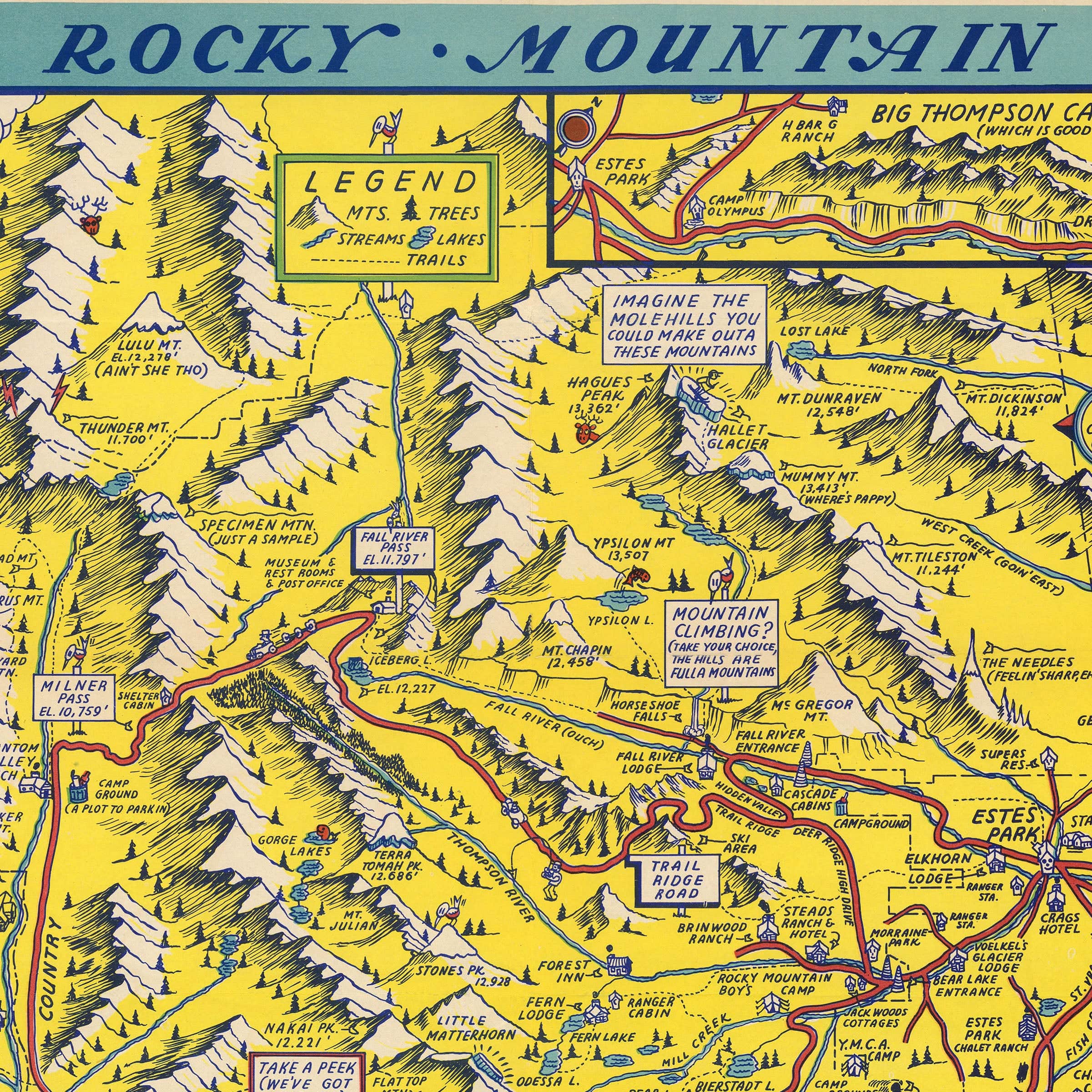
Against a brilliant golden backdrop, the park's towering peaks spring to life in playful exaggeration. Longs Peak dominates the scene with tongue-in-cheek warnings like "You Will Need Ropes, Pitons, Ice Crampons, and Good Insurance." Nearby ridges carry quips such as "Imagine the Molehills You Could Make Outa These Mountains," while Lulu Mountain gets the cheeky label "You Can't See Two." Trails wind like ribbons through forests and canyons, populated by cheerful illustrations of hikers, bears, and campers experiencing the wild beauty of Colorado.
What makes this map unforgettable is its refusal to take itself seriously. Every inch bursts with personality—handwritten notes, absurd symbols, and friendly jabs at the challenges of altitude, weather, and wildlife. The "legend" offers comedic guidance, turning the traditional cartographic format into a storytelling device. Lindgren transforms geography into comedy, making each mountain a character and every canyon a punchline.
This was 1948, a time when Americans were hitting the highways in record numbers. Gas rationing had ended, car ownership was soaring, and families packed station wagons for adventures they'd postponed during World War II. National parks like Rocky Mountain were experiencing unprecedented popularity as Americans rediscovered the natural wonders in their own backyard. Lindgren's map captured that optimism perfectly—inviting travelers not just to visit, but to laugh, explore, and fall in love with the rugged grandeur of the high country.
Yet beneath the humor lies genuine affection for the landscape. The peaks are rendered with care, rivers flow with movement, and forests feel alive with detail. Lindgren understood that maps could do more than show the way—they could tell stories, evoke emotion, and make you smile while getting lost in the scenery. His work reminds us that adventure and laughter go hand in hand.
Published by the Lindgren Brothers of Spokane, Washington, this map represents a unique moment in American cartography when pictorial maps flourished as souvenirs and decorative art. Today, it stands as both a charming piece of midcentury design and a window into the postwar spirit of exploration and joy.
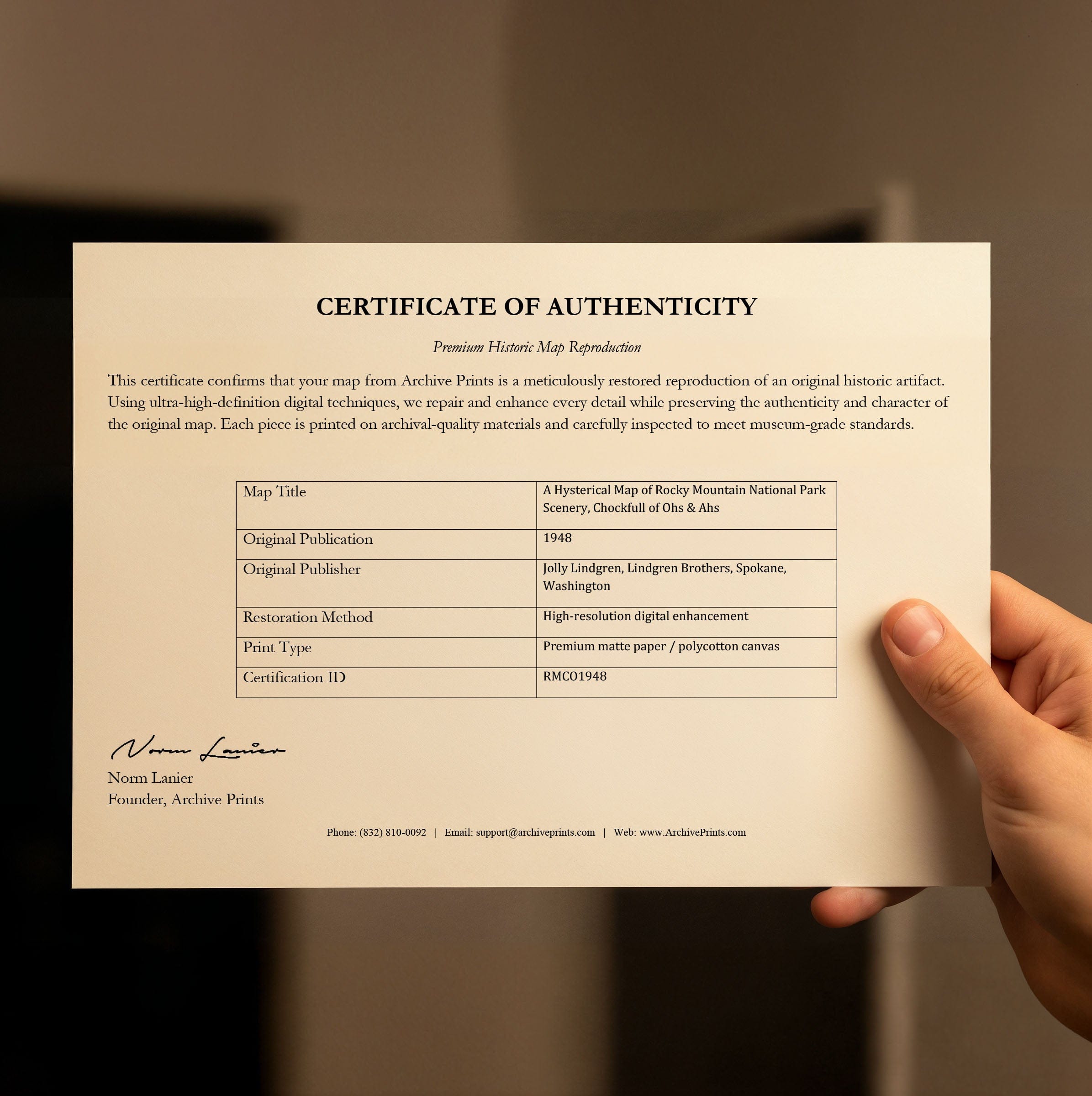
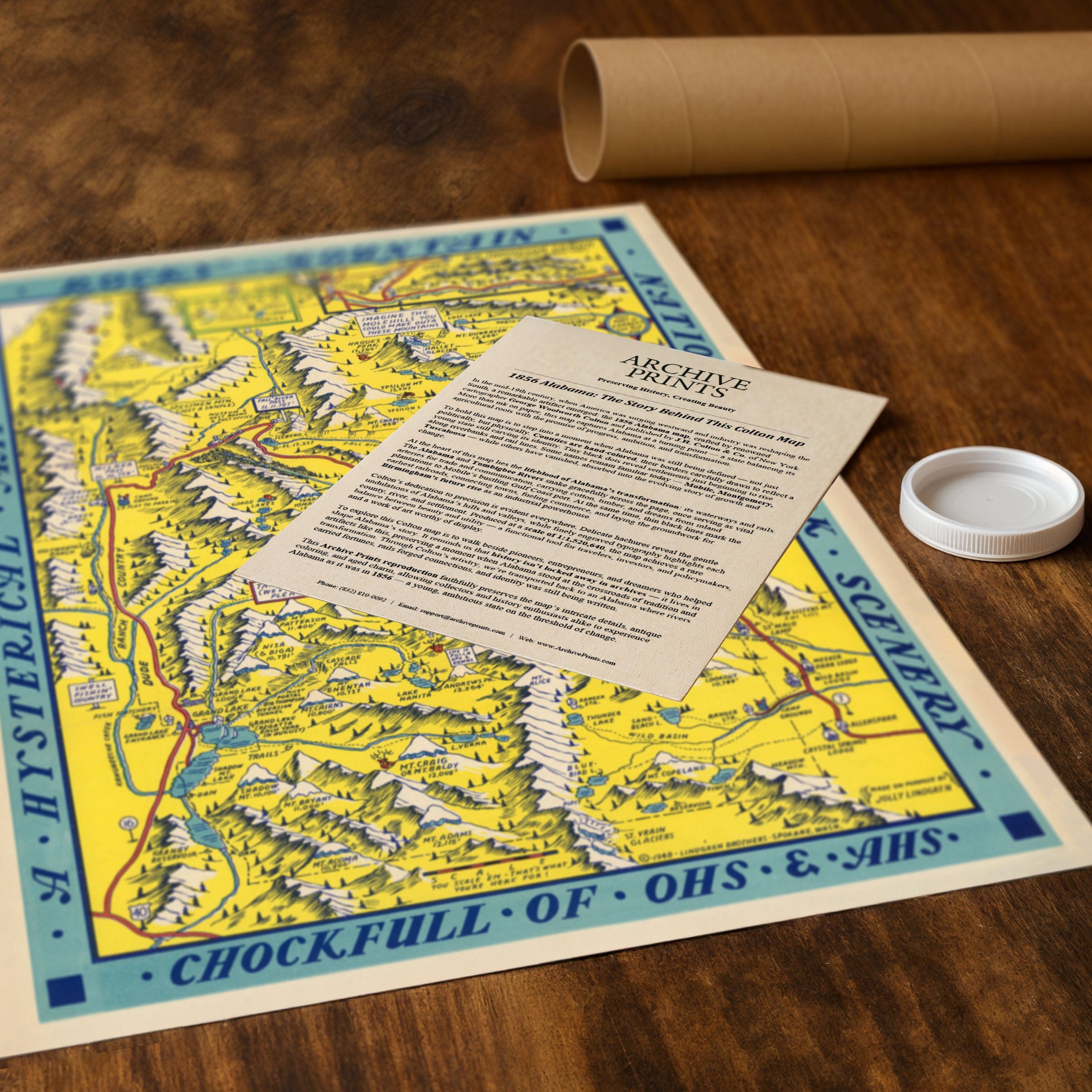
Each reproduction includes a custom historical letter detailing the story behind the map, making it perfect for Colorado enthusiasts, national park lovers, vintage travel collectors, and anyone who appreciates art that doesn't take itself too seriously. Printed on heavyweight archival paper or hand-stretched polycotton canvas, every quirky caption, illustrated character, and mountain ridge is restored in museum-grade clarity for generations of enjoyment.
Paper prints ship rolled in heavy-duty tubes, while canvas editions arrive gallery-wrapped on solid pine stretcher bars with pre-installed hardware—ready to display the moment it arrives. Bring home a piece of Colorado's playful cartographic history and celebrate the spirit of adventure that defined postwar America.
The Map Story
Materials
Choose options

Because every place has a story
Make History Personal
A vintage map is more than art.
It is a reminder of where life began.
Where memories were made.
Where hearts still live. Give the gift of place.
Beautifully preserved and made for the moments that matter.
Why Choose Us?
| Feature | Us | Competitor A | Competitor B |
|---|---|---|---|
| Hand Crafted | |||
| Museum Quality | |||
| 100 Year Guarantee | |||
| Restored by Hand | |||
| Certificate of Authenticity |

Art Prints
Archival quality colors. Best option if you'd like to frame it yourself

The Best Materials
We hand-stretched our canvas on solid American-grown pine stretcher bars. We use quality canvas and fade-resistant inks to create the lasting art. Canvases come with hardware already installed and ready to hang.
Need help?
Frequently Asked Questions
Order
All of our maps are meticulously restored reproductions of historic originals. Each piece is digitally repaired and color-corrected to bring out the finest details while preserving its authentic, vintage character.
Yes. All Archive Prints products are printed to order in the USA with archival materials.
We offer two premium formats:
- High-Quality Paper Posters – Printed on thick, archival-grade matte paper for rich, vibrant detail.
- Hand-Stretched Canvas Prints – Printed on premium polycotton canvas and mounted on 1.5" solid American pine stretcher bars for a gallery-quality finish.
We carefully digitally restore each map to enhance clarity and color while preserving its original look and historic charm. You’ll enjoy sharp details and a timeless vintage aesthetic that feels true to the original piece.
Yes, we do! We offer premium framing options to make your map ready to hang the moment it arrives. You can choose from Oak, Maple, Black, or Walnut frames directly on the product page. We also offer Stretched Canvas prints for a modern gallery look, as well as archival-quality Posters if you prefer to frame it yourself.
Yes! We offer free shipping on all products within the United States. Each map is carefully packaged to ensure it arrives in perfect condition.
If you’re not completely satisfied, you can return your order in new condition for a full refund. Return shipping costs are the responsibility of the customer.
Absolutely! Our maps make thoughtful, one-of-a-kind gifts for history lovers, map collectors, or anyone looking to add vintage character to their home or office. Choose between paper prints for framing or stretched canvas for a ready-to-hang presentation.
- Paper Posters → Shipped in durable, protective tubes to prevent creasing.
- Canvas Prints → Carefully wrapped, padded, and boxed to ensure safe delivery.
Our maps look stunning in a variety of settings, including:
- Living rooms and home offices
- Libraries and studies
- Corporate offices and conference rooms
- Restaurants, cafes, and boutique spaces