

San Diego Bird's-Eye Map - Vintage 1876 California Historical City Map
Discover San Diego's Frontier Dreams
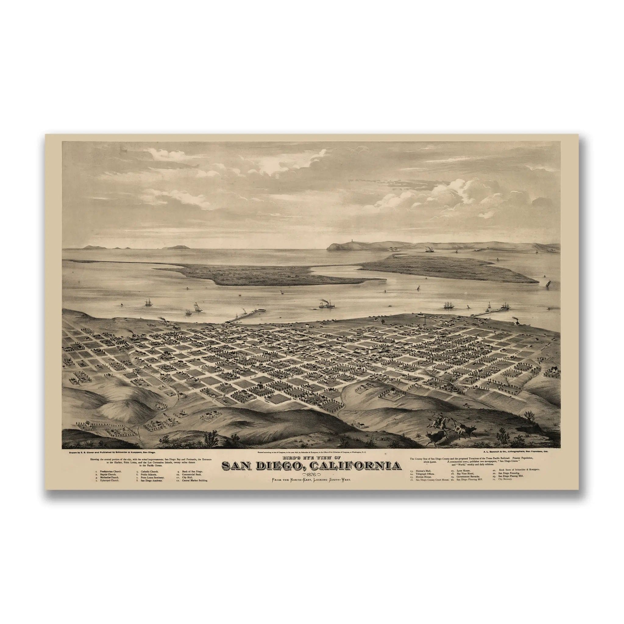
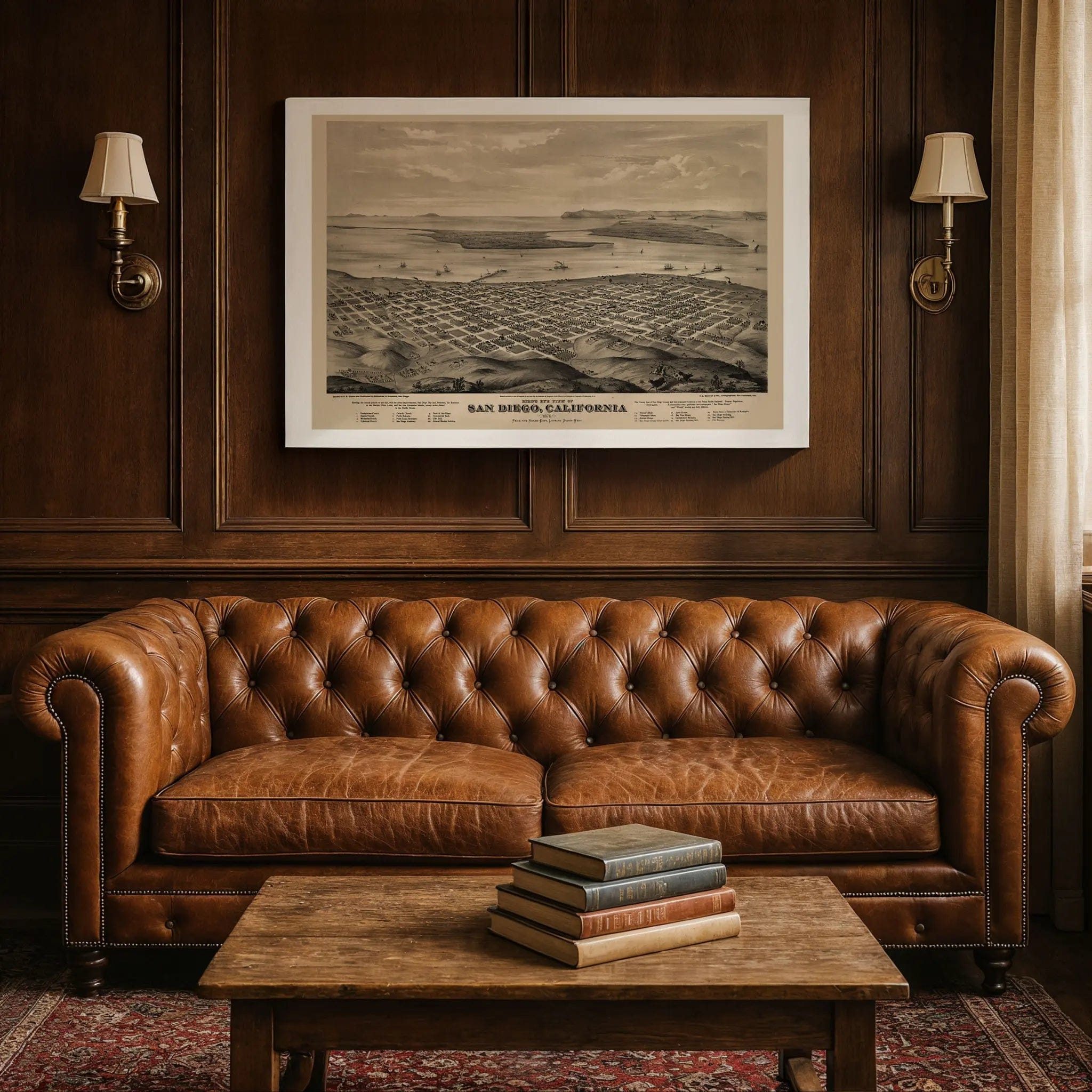
Step back into 1876 California with this extraordinary Bird's-Eye View of San Diego by E.S. Glover, published by A.L. Bancroft & Co. of San Francisco. This remarkable panoramic lithograph captures San Diego at a pivotal moment when it was still more dream than city—a frontier settlement balanced between desert and ocean, awaiting the promise of railroads and commerce to transform it into the thriving metropolis it would become.
Historical Significance
In 1876, San Diego stood as the county seat but not yet the bustling port it would one day become. The city's founders had pinned their hopes on the arrival of the Texas and Pacific Railroad, which promised to make San Diego the western terminus of a transcontinental line. This map captures the city during that era of fragile optimism, when investors and settlers poured in, buying plots and planning neighborhoods that existed mostly on paper. The perfect grid layout reflects the orderly optimism of American city planning, while the open hills suggest how much of the future still lay untouched.
Cartographic Excellence
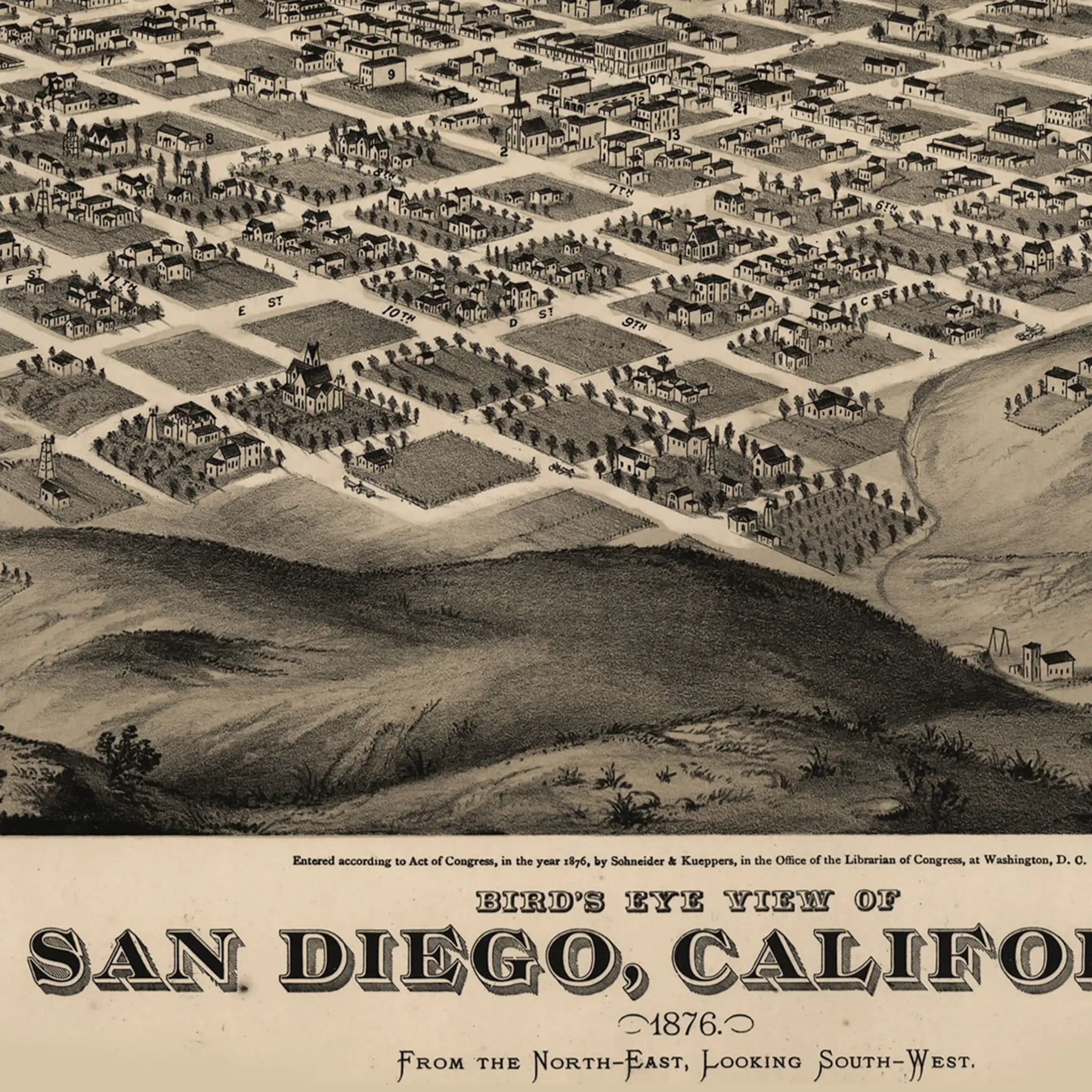
Glover's masterful composition presents San Diego from the northeast looking southwest across the bay, showcasing the city's strategic position between land and sea. Every block is meticulously plotted though many remain empty—evidence of grand vision ahead of population. At the water's edge, ships lie anchored near long wooden piers, symbols of connection to the wider Pacific world. Across the bay, the thin finger of Coronado Peninsula stretches outward, and beyond it the Pacific glimmers in the distance, creating a serene, almost pastoral scene punctuated by cattle and riders in the hills.
Urban Development Story
The streets—marked with civic pride as lettered avenues—reflect the systematic approach to Western expansion, while churches, schools, and public halls are labeled proudly in the key below. Each building represents not what the city was, but what it aspired to become. This map serves as more than a record of geography—it's a portrait of faith in progress, where every building, dock, and waterfront line was drawn with conviction that San Diego would rise into prosperity.
A Vision Realized
When the railroad project initially failed to materialize, land speculation collapsed, leaving behind a quiet, half-built city that seemed to pause between dreams. However, Glover's composition captures that mixture of promise and patience perfectly. Within two decades, that belief proved true as the arrival of the railroad in the 1880s and the Navy's later establishment in the harbor transformed this quiet grid into the foundation of a thriving coastal metropolis.
A Piece of California History
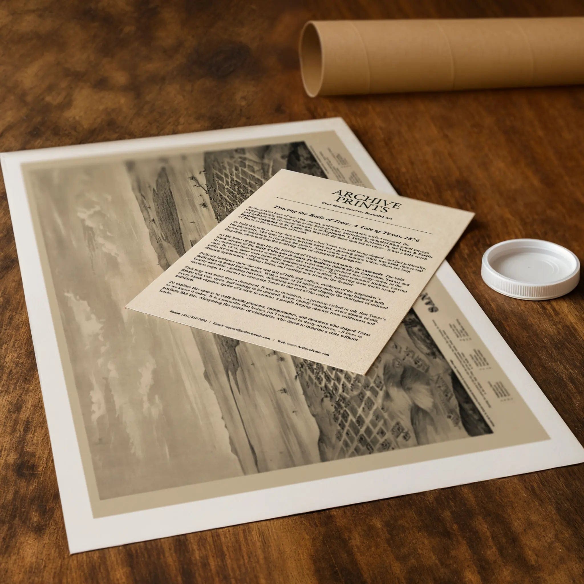
Each restored reproduction of this 1876 map is printed with museum-quality precision on heavyweight archival paper or hand-stretched premium canvas to preserve every original detail. Your purchase includes two companion documents:
Certificate of Authenticity verifying its restoration and reproduction quality
Historical Story Page detailing the origins, craftsmanship, and cultural significance of Glover's iconic map
Paper prints arrive rolled in reinforced mailing tubes for protection. Canvas prints come gallery-wrapped on solid pine stretcher bars with pre-installed hardware, ready to display upon arrival.
Bring home a vivid piece of California history—a timeless record of San Diego's frontier dreams and the vision that transformed a frontier settlement into one of America's most beautiful coastal cities.
The Map Story
In 1876, San Diego was still a dream more than a city—a frontier settlement balanced between desert and ocean, awaiting the promise of railroads and commerce to transform it. This panoramic lithograph, titled “Bird’s-Eye View of San Diego, California,” was drawn by E.S. Glover and published by A.L. Bancroft & Co. of San Francisco. Seen from the northeast looking southwest across the bay, the image captures San Diego at a moment of fragile optimism, its streets neatly drawn but its future uncertain.
The city is laid out in a perfect grid, every block meticulously plotted though many remain empty—evidence of grand vision ahead of population. At the water’s edge, a few ships lie anchored near long wooden piers, symbols of connection to the wider Pacific world. Across the bay, the thin finger of Coronado Peninsula stretches outward, and beyond it the Pacific glimmers in the distance. The landscape is serene, almost pastoral, punctuated by the faint outlines of cattle and riders in the hills.
In 1876, San Diego was the county seat but not yet the bustling port it would one day become. Its founders had pinned their hopes on the arrival of the Texas and Pacific Railroad, which promised to make the city the western terminus of a transcontinental line. Investors and settlers poured in, buying plots and planning neighborhoods that existed mostly on paper. When the railroad project failed to materialize, land speculation collapsed, leaving behind a quiet, half-built city that seemed to pause between dreams.
Glover’s composition captures that mixture of promise and patience. The streets—marked with civic pride as “A,” “B,” and “C”—reflect the orderly optimism of American city planning, while the open hills suggest how much of the future still lay untouched. Churches, schools, and public halls are labeled proudly in the key below, each representing not what the city was, but what it aspired to become.
This map is more than a record of geography—it is a portrait of faith in progress. Every building, every dock, every line of the waterfront was drawn with conviction that San Diego would rise into prosperity. Within two decades, that belief proved true. The arrival of the railroad in the 1880s and the Navy’s later establishment in the harbor would make Glover’s quiet grid the foundation of a thriving coastal metropolis.
Materials
Choose options

Because every place has a story
Make History Personal
A vintage map is more than art.
It is a reminder of where life began.
Where memories were made.
Where hearts still live. Give the gift of place.
Beautifully preserved and made for the moments that matter.
Why Choose Us?
| Feature | Us | Competitor A | Competitor B |
|---|---|---|---|
| Hand Crafted | |||
| Museum Quality | |||
| 100 Year Guarantee | |||
| Restored by Hand | |||
| Certificate of Authenticity |

Art Prints
Archival quality colors. Best option if you'd like to frame it yourself

The Best Materials
We hand-stretched our canvas on solid American-grown pine stretcher bars. We use quality canvas and fade-resistant inks to create the lasting art. Canvases come with hardware already installed and ready to hang.
Need help?
Frequently Asked Questions
Order
All of our maps are meticulously restored reproductions of historic originals. Each piece is digitally repaired and color-corrected to bring out the finest details while preserving its authentic, vintage character.
Yes. All Archive Prints products are printed to order in the USA with archival materials.
We offer two premium formats:
- High-Quality Paper Posters – Printed on thick, archival-grade matte paper for rich, vibrant detail.
- Hand-Stretched Canvas Prints – Printed on premium polycotton canvas and mounted on 1.5" solid American pine stretcher bars for a gallery-quality finish.
We carefully digitally restore each map to enhance clarity and color while preserving its original look and historic charm. You’ll enjoy sharp details and a timeless vintage aesthetic that feels true to the original piece.
Yes, we do! We offer premium framing options to make your map ready to hang the moment it arrives. You can choose from Oak, Maple, Black, or Walnut frames directly on the product page. We also offer Stretched Canvas prints for a modern gallery look, as well as archival-quality Posters if you prefer to frame it yourself.
Yes! We offer free shipping on all products within the United States. Each map is carefully packaged to ensure it arrives in perfect condition.
If you’re not completely satisfied, you can return your order in new condition for a full refund. Return shipping costs are the responsibility of the customer.
Absolutely! Our maps make thoughtful, one-of-a-kind gifts for history lovers, map collectors, or anyone looking to add vintage character to their home or office. Choose between paper prints for framing or stretched canvas for a ready-to-hang presentation.
- Paper Posters → Shipped in durable, protective tubes to prevent creasing.
- Canvas Prints → Carefully wrapped, padded, and boxed to ensure safe delivery.
Our maps look stunning in a variety of settings, including:
- Living rooms and home offices
- Libraries and studies
- Corporate offices and conference rooms
- Restaurants, cafes, and boutique spaces