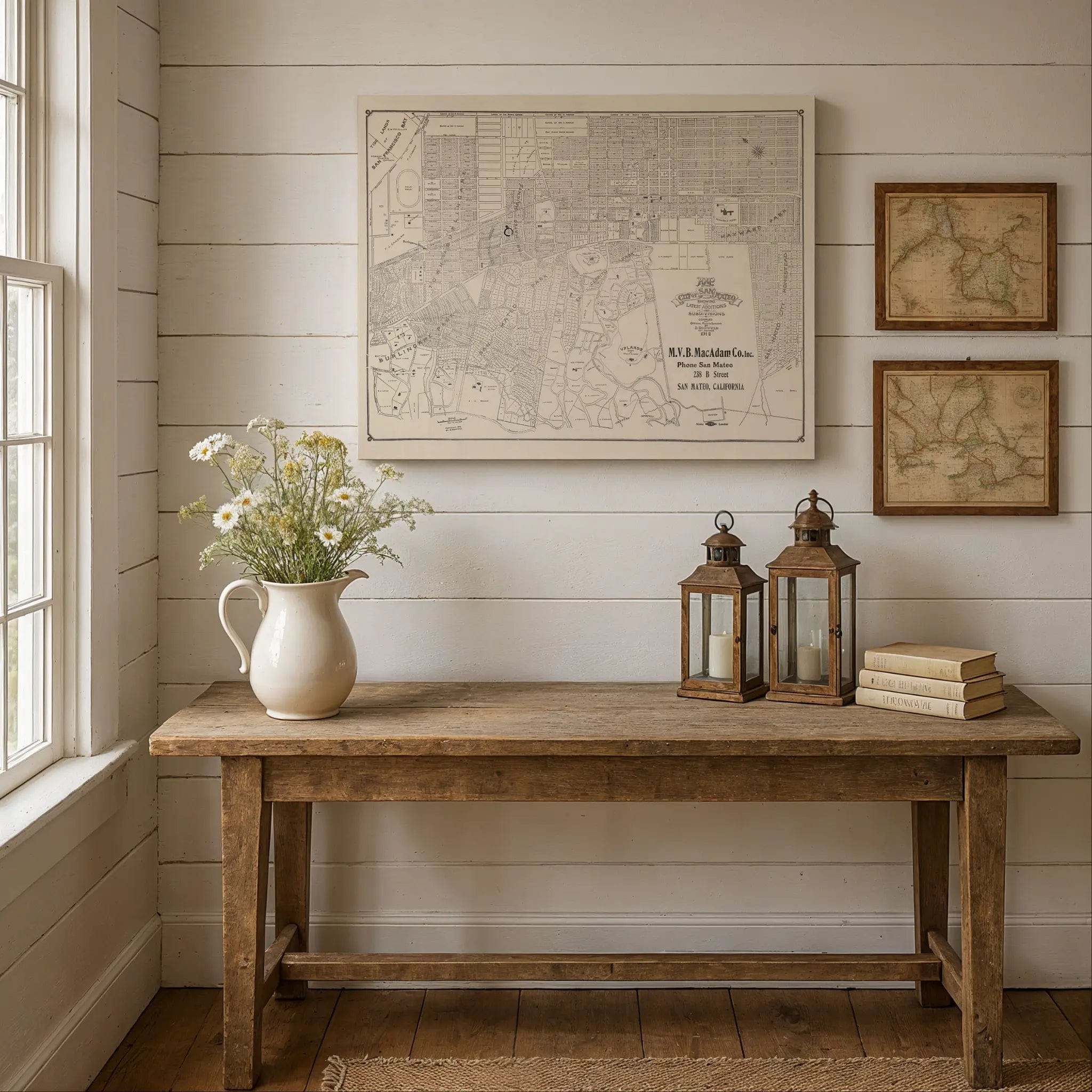
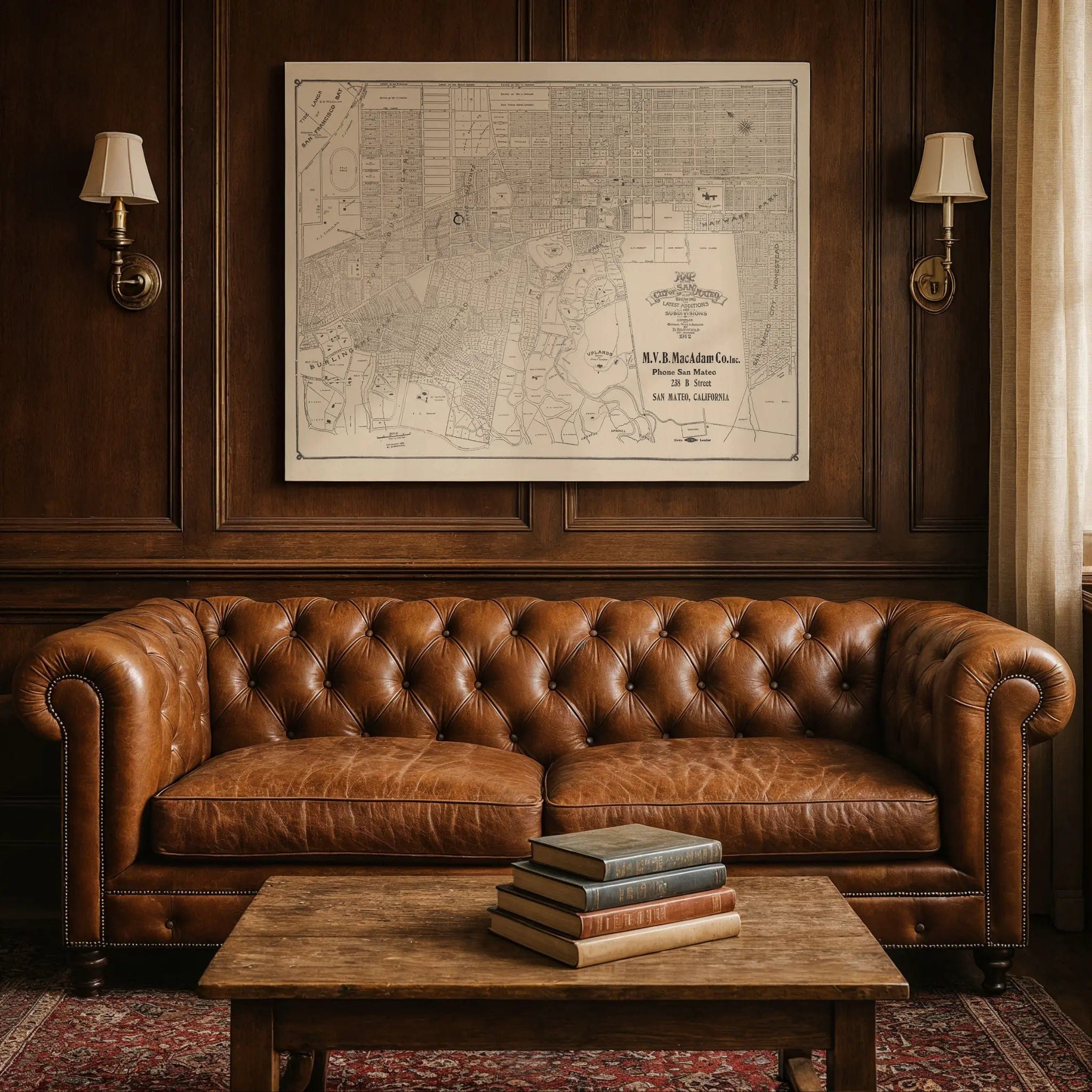

San Mateo Vintage Map - 1912 City Planning & Subdivisions Map
Discover the Peninsula's Garden City
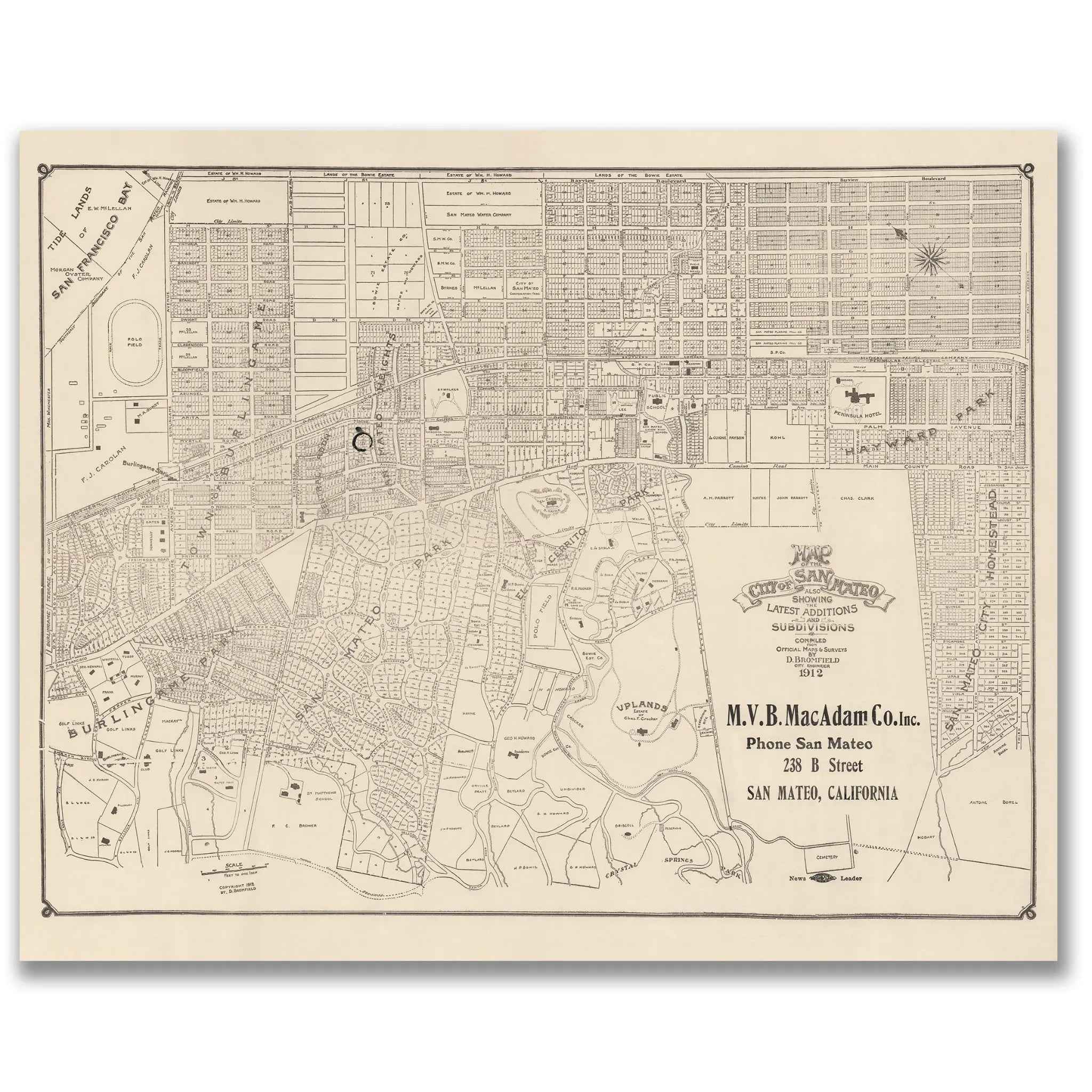
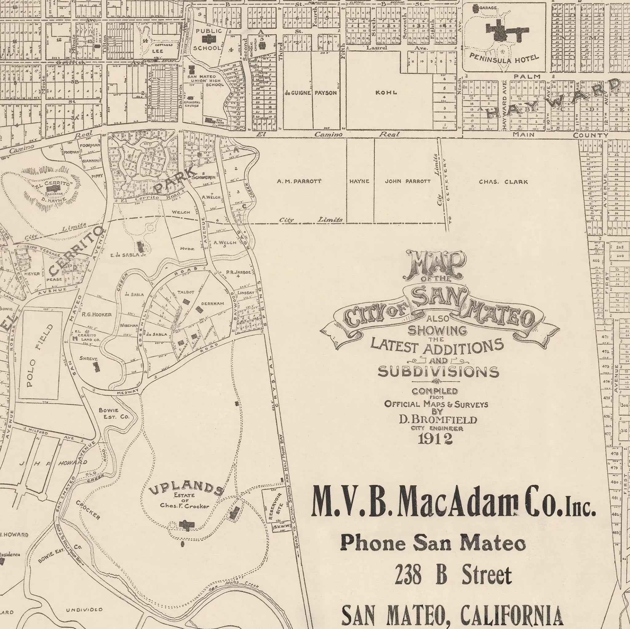
Step into the remarkable world of 1912 San Mateo with this meticulously detailed city planning map that captures California's Peninsula during one of its most dynamic periods of suburban development. Compiled by D.B. Blomfield for M.V.B. MacAdam Co., this extraordinary cartographic document reveals San Mateo as it emerged as one of California's premier planned communities, showcasing the city during the height of the early 20th-century suburban boom when the Peninsula was transforming from agricultural land into one of America's most desirable residential destinations.
Historical Significance
In 1912, San Mateo stood at the forefront of American suburban planning, representing the new California dream of planned communities that balanced urban convenience with small-town charm. This comprehensive city map documents San Mateo during a pivotal moment when the Peninsula was experiencing unprecedented growth following the 1906 San Francisco earthquake, as residents sought safer, more spacious living while maintaining access to the Bay Area's economic opportunities. The map showcases not just streets and lots, but the visionary planning that made San Mateo a model for suburban development—from the elegant Peninsula Hotel and carefully platted residential subdivisions to the systematic street grid that accommodated both existing topography and future growth.
Cartographic Excellence
This masterful planning map represents the pinnacle of early 20th-century municipal cartography, combining precise surveying with comprehensive development documentation. The detailed rendering reveals San Mateo's distinctive approach to suburban planning, showing how the city's layout respected natural features while creating orderly neighborhoods designed for modern living. The map captures the essence of a community built for growth and prosperity, with detailed documentation of subdivisions, lot numbers, and the careful integration of commercial and residential areas that made San Mateo a pioneer in thoughtful urban development.
Suburban Development Story
Within the carefully mapped streets and subdivisions, the story of American suburban innovation unfolds through the systematic layout of neighborhoods, commercial districts, and public spaces. The map captures San Mateo during its emergence as a Peninsula destination, featuring everything from the prestigious Peninsula Hotel that attracted visitors from San Francisco to the carefully planned residential subdivisions that offered modern families the perfect blend of suburban tranquility and urban accessibility. The detailed documentation of latest additions and subdivisions reflects the rapid growth and careful planning that made San Mateo a model for California suburban development.
Peninsula Heritage
Beyond its function as a planning document, this map represents the vision and ambition that made San Mateo the symbol of California suburban sophistication. The careful documentation of subdivisions, lot layouts, and commercial areas reveals how the community was designed to accommodate both established residents and the constant flow of new families seeking the California lifestyle. The presence of the Peninsula Hotel and the systematic street planning captures the unique balance of elegance and accessibility that made San Mateo a premier Peninsula destination.
This detailed cartographic record preserves San Mateo at a moment of tremendous growth and optimism—when the city was establishing the planning principles and community character that would make it one of California's most desirable places to live. The map captures the essence of a community that valued both careful planning and quality of life, creating the suburban ideal that influenced Peninsula development for generations. Perfect for San Mateo residents, Peninsula history enthusiasts, and collectors of vintage city planning maps, this restored map serves as both a historical treasure and a stunning piece of wall art that celebrates the vision and foresight that built one of California's premier suburban communities.
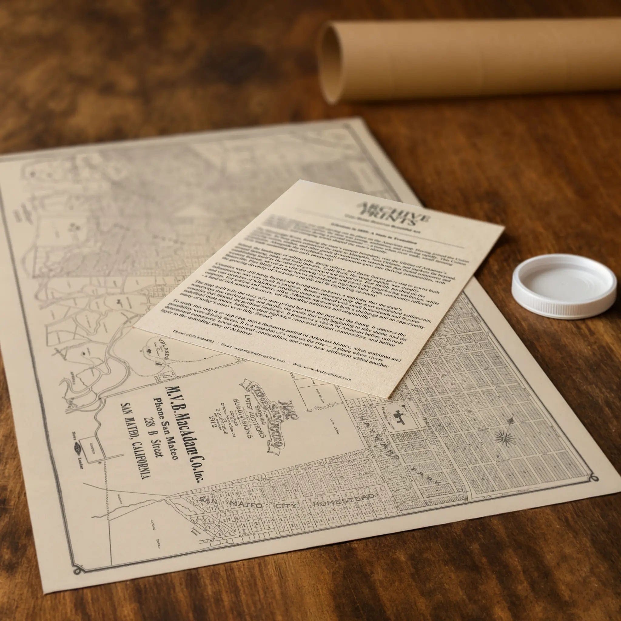
Each reproduction includes a custom historical letter detailing San Mateo's role in early 20th-century suburban development and the innovative planning that made the Peninsula a model for California communities. Printed on heavyweight archival paper or premium canvas, every street, subdivision, and planning detail is preserved with museum-quality clarity through expert digital restoration.
For protection and presentation, paper prints arrive rolled in sturdy mailing tubes, while canvas prints come gallery-wrapped on solid pine stretcher bars with pre-installed hanging hardware—ready to display immediately.
Bring home a piece of Peninsula history with this captivating glimpse into San Mateo during its golden age of suburban planning and development.
The Map Story
This 1912 map of San Mateo was produced by the firm M. V. B. MacAdam Co. and compiled from official records by D. B. Blodfield. It offers a fascinating window into a Bay Area community at the height of its suburban transformation. Nestled between San Francisco and Palo Alto along the western shore of San Francisco Bay, San Mateo had grown rapidly in the early twentieth century as transportation, industry, and real estate reshaped the peninsula.
The map shows the city in remarkable detail, with new subdivisions and residential tracts carefully drawn and labeled. Neighborhoods such as Uplands, Hayward Park, and other additions are clearly identified, reflecting the suburban development boom that followed the 1906 San Francisco earthquake. Families and investors sought stability and open land away from the rebuilt metropolis, and San Mateo, with its mild climate and proximity to the Bay, became a natural magnet for growth.
Transportation corridors dominate the map. The Southern Pacific Railroad runs north-south, anchoring the city’s connection to San Francisco and the wider region. Nearby, El Camino Real traces its historic route, lined with commercial and residential development that would become the spine of the Peninsula. The proximity to the Bay, with tidal lands and marshes noted, highlights both the opportunities and challenges of expansion in an area where engineering and reclamation played crucial roles.
Land ownership and subdivision patterns are prominent features. Parcels tied to historic estates and ranch lands are broken into gridded neighborhoods, each advertised as a new opportunity for middle-class families. The map’s inclusion of hotels, schools, and civic buildings shows a community confident in its identity as a modern suburb, no longer just a retreat for wealthy San Franciscans but an emerging city in its own right.
The 1912 San Mateo map captures a community balancing tradition and progress. While rooted in the agricultural and estate culture of the late nineteenth century, the city was firmly on a path toward integration with the broader Bay Area economy. It illustrates the optimism of the era, when new subdivisions promised prosperity and the railroad tied residents to both local industry and metropolitan opportunity. Today the map survives as both a planning document and a cultural artifact, preserving the blueprint of a city on the threshold of modern suburbia.
Materials
Hand‑Stretched Canvas: If you choose canvas, we use a premium cotton‑poly blend stretched over solid pine frames. Each canvas is carefully hand‑stretched for a tight, gallery‑quality finish that's ready to hang right out of the box.
Vivid, Fade‑Resistant Inks: We use professional‑grade inks that are UV‑resistant, so your print retains its rich colors even when displayed in bright rooms.
Expert Restoration: Every map is digitally restored by skilled artisans. We preserve the character of the original while enhancing clarity, so you see the map as it was meant to be seen.
Secure Packaging: Paper prints are rolled in heavy‑duty mailing tubes, and canvases are cushioned in reinforced boxes to ensure they arrive in pristine condition.
Choosing one of our prints means investing in craftsmanship. We combine historical authenticity with modern print technology and premium materials, giving you a work of art built to stand the test of time.
Choose options

Because every place has a story
Make History Personal
A vintage map is more than art.
It is a reminder of where life began.
Where memories were made.
Where hearts still live. Give the gift of place.
Beautifully preserved and made for the moments that matter.
Why Choose Us?
| Feature | Us | Competitor A | Competitor B |
|---|---|---|---|
| Hand Crafted | |||
| Museum Quality | |||
| 100 Year Guarantee | |||
| Restored by Hand | |||
| Certificate of Authenticity |

Art Prints
Archival quality colors. Best option if you'd like to frame it yourself

The Best Materials
We hand-stretched our canvas on solid American-grown pine stretcher bars. We use quality canvas and fade-resistant inks to create the lasting art. Canvases come with hardware already installed and ready to hang.
Need help?
Frequently Asked Questions
Order
All of our maps are meticulously restored reproductions of historic originals. Each piece is digitally repaired and color-corrected to bring out the finest details while preserving its authentic, vintage character.
Yes. All Archive Prints products are printed to order in the USA with archival materials.
We offer two premium formats:
- High-Quality Paper Posters – Printed on thick, archival-grade matte paper for rich, vibrant detail.
- Hand-Stretched Canvas Prints – Printed on premium polycotton canvas and mounted on 1.5" solid American pine stretcher bars for a gallery-quality finish.
We carefully digitally restore each map to enhance clarity and color while preserving its original look and historic charm. You’ll enjoy sharp details and a timeless vintage aesthetic that feels true to the original piece.
Yes, we do! We offer premium framing options to make your map ready to hang the moment it arrives. You can choose from Oak, Maple, Black, or Walnut frames directly on the product page. We also offer Stretched Canvas prints for a modern gallery look, as well as archival-quality Posters if you prefer to frame it yourself.
Yes! We offer free shipping on all products within the United States. Each map is carefully packaged to ensure it arrives in perfect condition.
If you’re not completely satisfied, you can return your order in new condition for a full refund. Return shipping costs are the responsibility of the customer.
Absolutely! Our maps make thoughtful, one-of-a-kind gifts for history lovers, map collectors, or anyone looking to add vintage character to their home or office. Choose between paper prints for framing or stretched canvas for a ready-to-hang presentation.
- Paper Posters → Shipped in durable, protective tubes to prevent creasing.
- Canvas Prints → Carefully wrapped, padded, and boxed to ensure safe delivery.
Our maps look stunning in a variety of settings, including:
- Living rooms and home offices
- Libraries and studies
- Corporate offices and conference rooms
- Restaurants, cafes, and boutique spaces