
Savannah Georgia Historic Map - 1888 Bird's-Eye View of the City
Discover the Savannah Georgia Map That Captures Southern Elegance
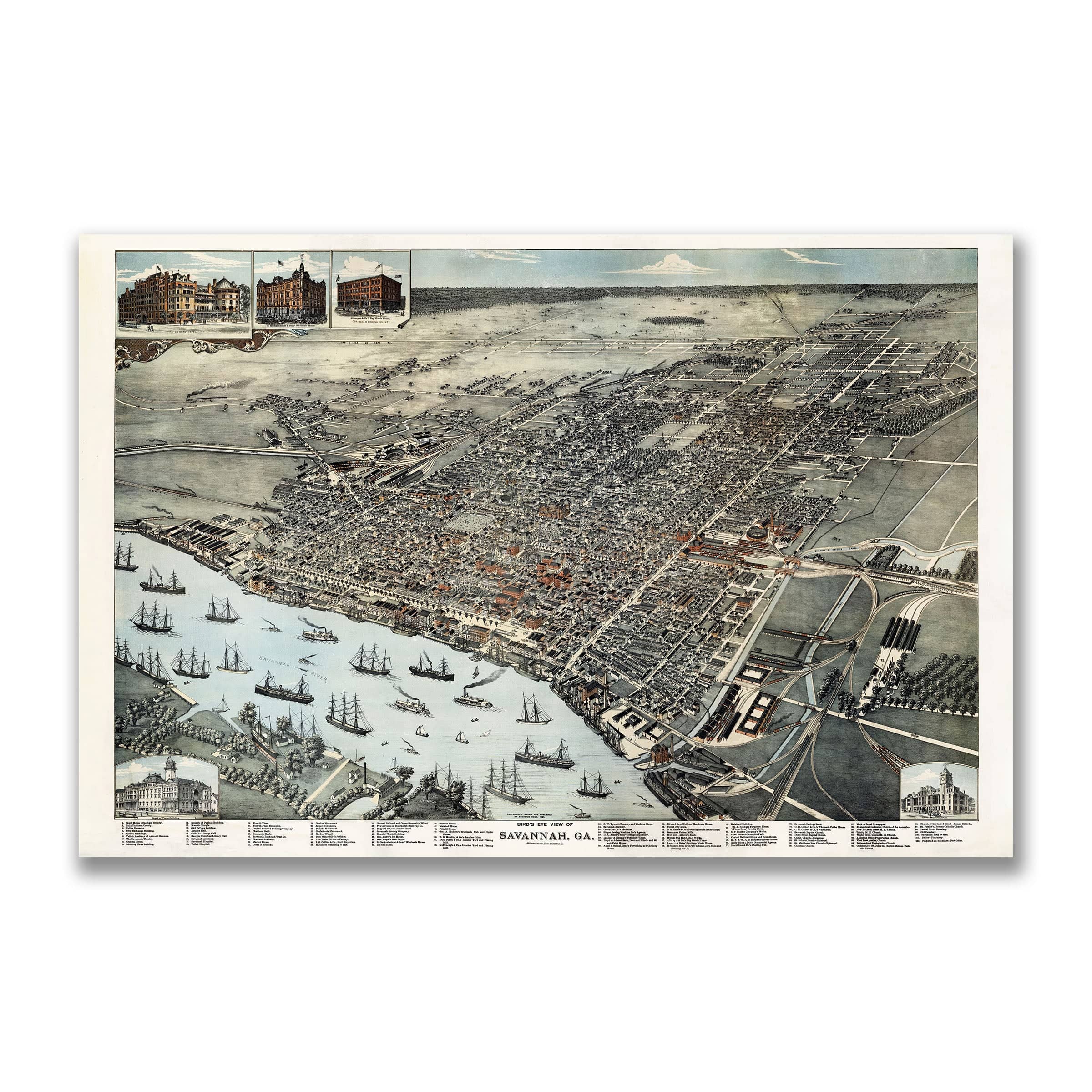
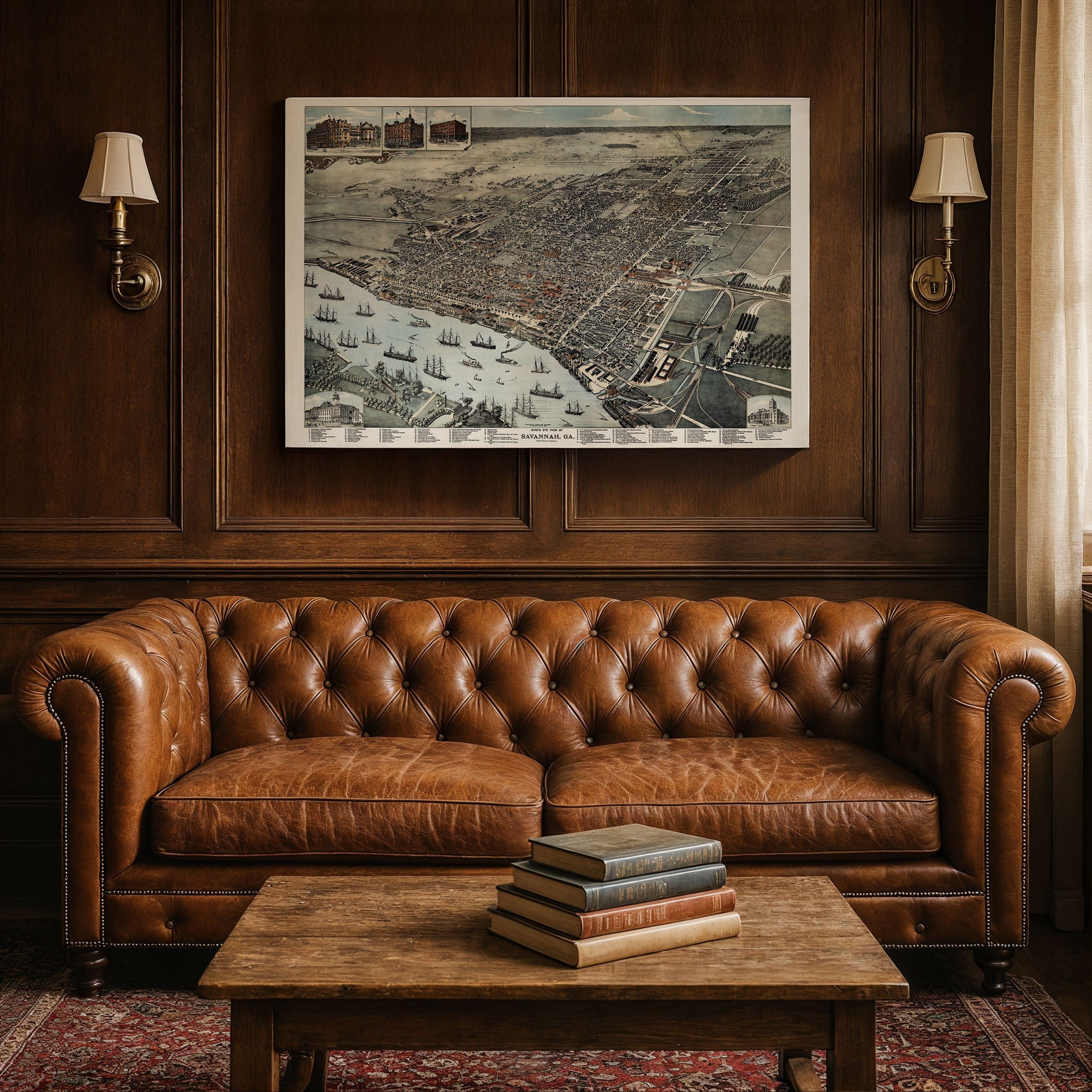
Travel back to 1888, when the Savannah Georgia Map revealed one of the South's most beautiful and industrious cities—a place where history met ambition on the banks of the Savannah River. This detailed panoramic lithograph, drawn and published by Henry Wellge & Co., captures the city at a pivotal moment when its graceful grid of shaded squares met the machinery of modern progress.Historical Significance of This Savannah Georgia Map
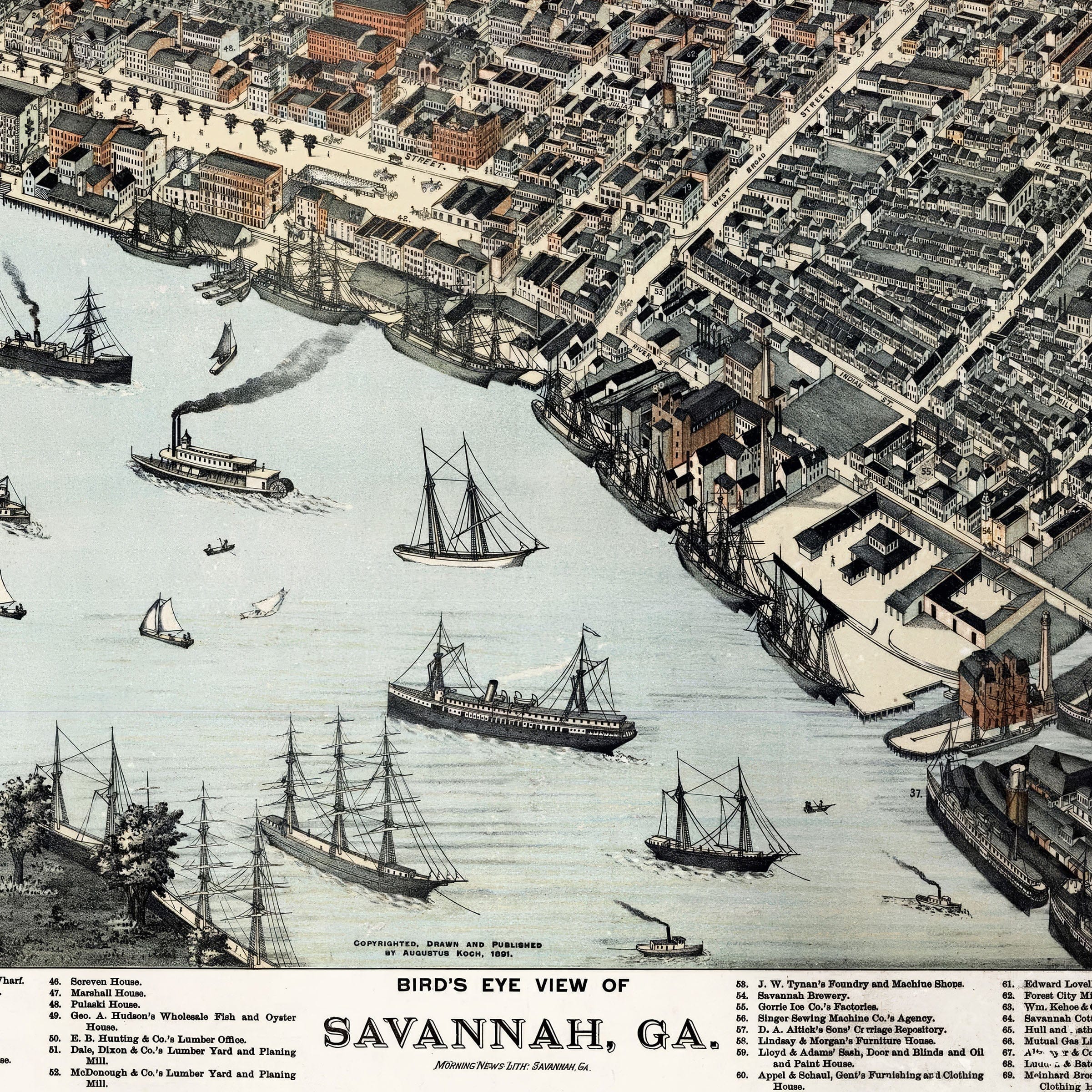
From above, the city reveals its famous plan: a network of tree-lined streets and orderly wards, each anchored by a public square. This design, envisioned by General James Oglethorpe in 1733, still defined Savannah's rhythm more than a century later. Within this structure, red-brick warehouses, steepled churches, and elegant homes rise in perfect harmony—a testament to the city's balance between order and charm. The waterfront dominates the lower edge of the map, bustling with tall-masted ships, paddle steamers, and cargo barges. Here, cotton was king. Bales from inland plantations traveled by rail and river to be pressed, weighed, and loaded onto ships bound for Liverpool and New York. Every warehouse and wharf drawn on this map tells the story of commerce—the heartbeat of Savannah's economy and the source of its cosmopolitan character.Urban Development and Railroad Connections
To the east and west, the industrial face of the city comes into view: railyards, lumber mills, and foundries, all connected by looping tracks that stretch toward the horizon. These rail lines linked Savannah to the interior, making it not just a port but a hub—an artery through which the New South pumped its renewed energy after Reconstruction. Yet even amid this movement and expansion, Savannah held onto its elegance. The map's delicate shading shows wide boulevards lined with trees and homes surrounded by gardens. Civic landmarks like the courthouse, Custom House, and public market rise from the grid, symbols of stability and refinement in a city that had endured war and renewal alike.A Timeless Vision of Southern Grace
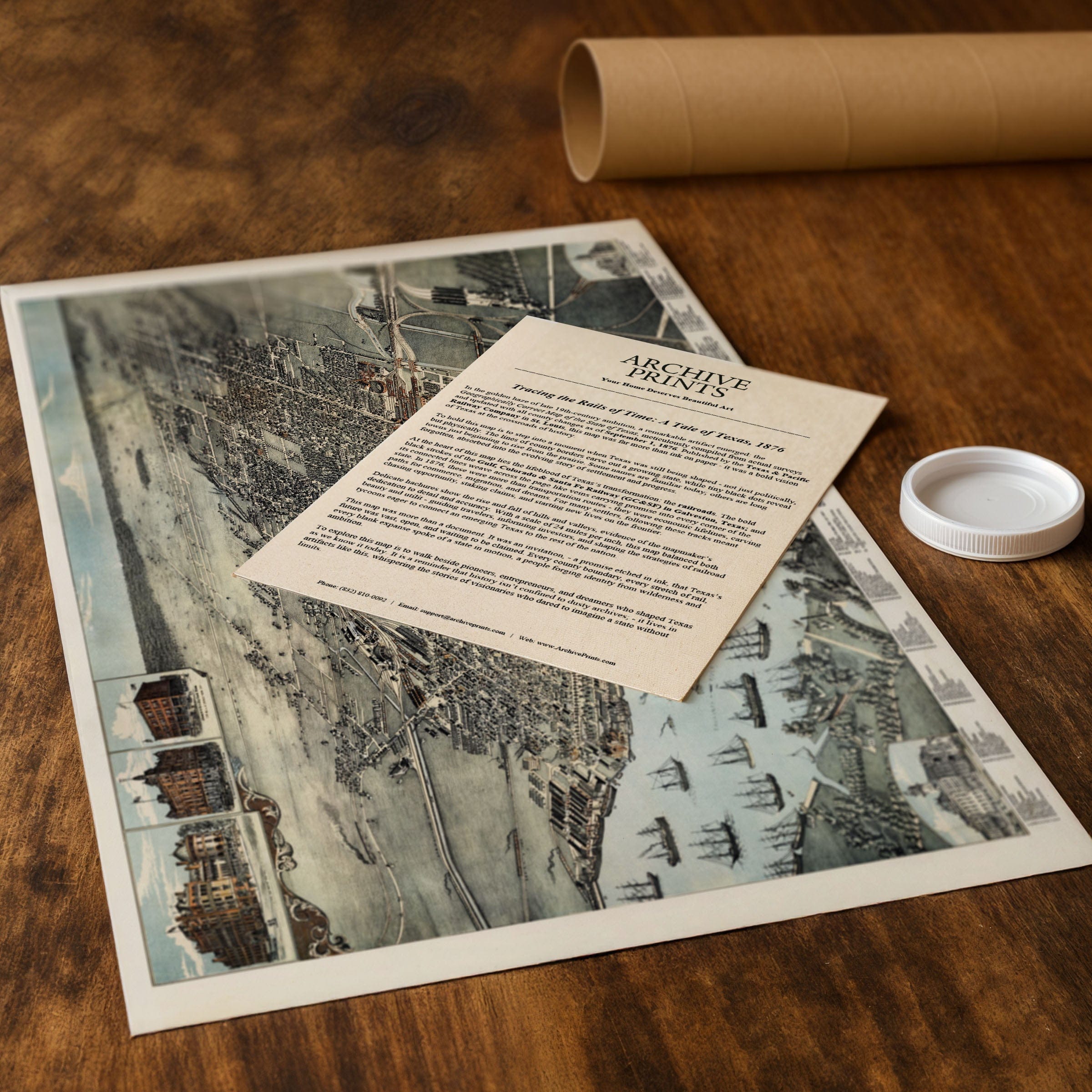
Viewed today, this 1888 panorama feels alive with continuity. The same squares remain shaded by live oaks, the river still hums with work, and the air of Savannah—part old-world grace, part southern ambition—endures. The map invites you to trace its streets and imagine the hum of wagons, the call of the riverboats, and the rhythm of a city that has never stopped balancing beauty with enterprise. Each reproduction includes a custom historical letter detailing the story behind the map, making it perfect for collectors, historians, and Southern heritage enthusiasts. Printed on heavyweight archival paper or hand-stretched polycotton canvas, every square, street, and waterfront detail is restored in museum-grade clarity for generations of enjoyment. Paper prints ship rolled in heavy-duty tubes, while canvas editions arrive gallery-wrapped on solid pine stretcher bars with pre-installed hardware—ready to display the moment it arrives. Bring home a piece of Savannah's timeless legacy and celebrate the vision that made this city the jewel of the Georgia coast.The Map Story
Bird’s-Eye View of Savannah, Georgia
In 1888, Savannah stood as one of the South’s most beautiful and industrious cities—a place where history met ambition on the banks of the Savannah River. This detailed panoramic lithograph, drawn and published by Henry Wellge & Co., captures the city at a pivotal moment when its graceful grid of shaded squares met the machinery of modern progress.
From above, the city reveals its famous plan: a network of tree-lined streets and orderly wards, each anchored by a public square. This design, envisioned by General James Oglethorpe in 1733, still defined Savannah’s rhythm more than a century later. Within this structure, red-brick warehouses, steepled churches, and elegant homes rise in perfect harmony—a testament to the city’s balance between order and charm.
The waterfront dominates the lower edge of the map, bustling with tall-masted ships, paddle steamers, and cargo barges. Here, cotton was king. Bales from inland plantations traveled by rail and river to be pressed, weighed, and loaded onto ships bound for Liverpool and New York. Every warehouse and wharf drawn on this map tells the story of commerce—the heartbeat of Savannah’s economy and the source of its cosmopolitan character.
To the east and west, the industrial face of the city comes into view: railyards, lumber mills, and foundries, all connected by looping tracks that stretch toward the horizon. These rail lines linked Savannah to the interior, making it not just a port but a hub—an artery through which the New South pumped its renewed energy after Reconstruction.
Yet even amid this movement and expansion, Savannah held onto its elegance. The map’s delicate shading shows wide boulevards lined with trees and homes surrounded by gardens. Civic landmarks like the courthouse, Custom House, and public market rise from the grid, symbols of stability and refinement in a city that had endured war and renewal alike.
Viewed today, this 1888 panorama feels alive with continuity. The same squares remain shaded by live oaks, the river still hums with work, and the air of Savannah—part old-world grace, part southern ambition—endures. The map invites you to trace its streets and imagine the hum of wagons, the call of the riverboats, and the rhythm of a city that has never stopped balancing beauty with enterprise.
Materials
Choose options

Because every place has a story
Make History Personal
A vintage map is more than art.
It is a reminder of where life began.
Where memories were made.
Where hearts still live. Give the gift of place.
Beautifully preserved and made for the moments that matter.
Why Choose Us?
| Feature | Us | Competitor A | Competitor B |
|---|---|---|---|
| Hand Crafted | |||
| Museum Quality | |||
| 100 Year Guarantee | |||
| Restored by Hand | |||
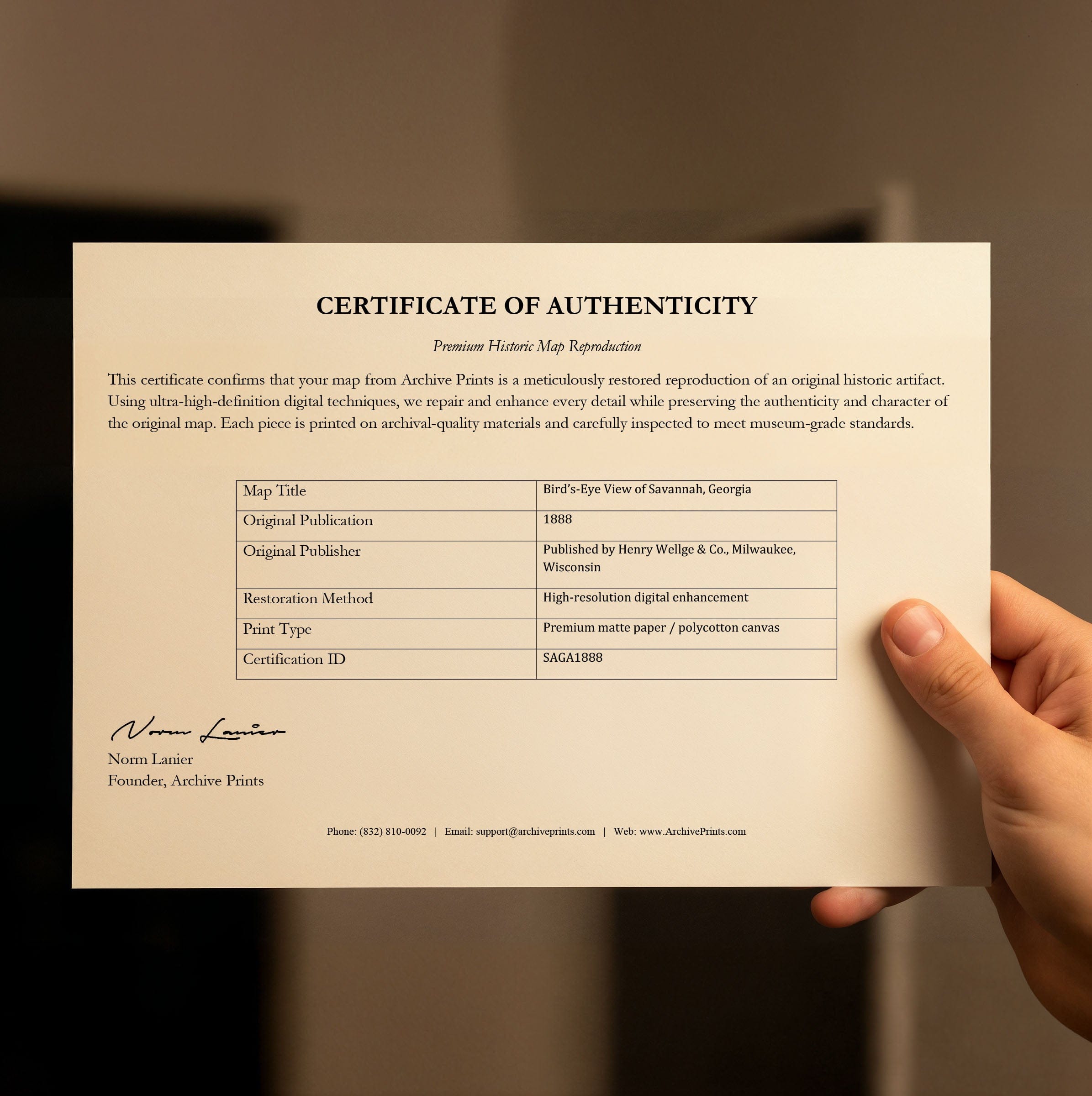
| Certificate of Authenticity |

Art Prints
Archival quality colors. Best option if you'd like to frame it yourself

The Best Materials
We hand-stretched our canvas on solid American-grown pine stretcher bars. We use quality canvas and fade-resistant inks to create the lasting art. Canvases come with hardware already installed and ready to hang.
Need help?
Frequently Asked Questions
Order
All of our maps are meticulously restored reproductions of historic originals. Each piece is digitally repaired and color-corrected to bring out the finest details while preserving its authentic, vintage character.
Yes. All Archive Prints products are printed to order in the USA with archival materials.
We offer two premium formats:
- High-Quality Paper Posters – Printed on thick, archival-grade matte paper for rich, vibrant detail.
- Hand-Stretched Canvas Prints – Printed on premium polycotton canvas and mounted on 1.5" solid American pine stretcher bars for a gallery-quality finish.
We carefully digitally restore each map to enhance clarity and color while preserving its original look and historic charm. You’ll enjoy sharp details and a timeless vintage aesthetic that feels true to the original piece.
Yes, we do! We offer premium framing options to make your map ready to hang the moment it arrives. You can choose from Oak, Maple, Black, or Walnut frames directly on the product page. We also offer Stretched Canvas prints for a modern gallery look, as well as archival-quality Posters if you prefer to frame it yourself.
Yes! We offer free shipping on all products within the United States. Each map is carefully packaged to ensure it arrives in perfect condition.
If you’re not completely satisfied, you can return your order in new condition for a full refund. Return shipping costs are the responsibility of the customer.
Absolutely! Our maps make thoughtful, one-of-a-kind gifts for history lovers, map collectors, or anyone looking to add vintage character to their home or office. Choose between paper prints for framing or stretched canvas for a ready-to-hang presentation.
- Paper Posters → Shipped in durable, protective tubes to prevent creasing.
- Canvas Prints → Carefully wrapped, padded, and boxed to ensure safe delivery.
Our maps look stunning in a variety of settings, including:
- Living rooms and home offices
- Libraries and studies
- Corporate offices and conference rooms
- Restaurants, cafes, and boutique spaces