
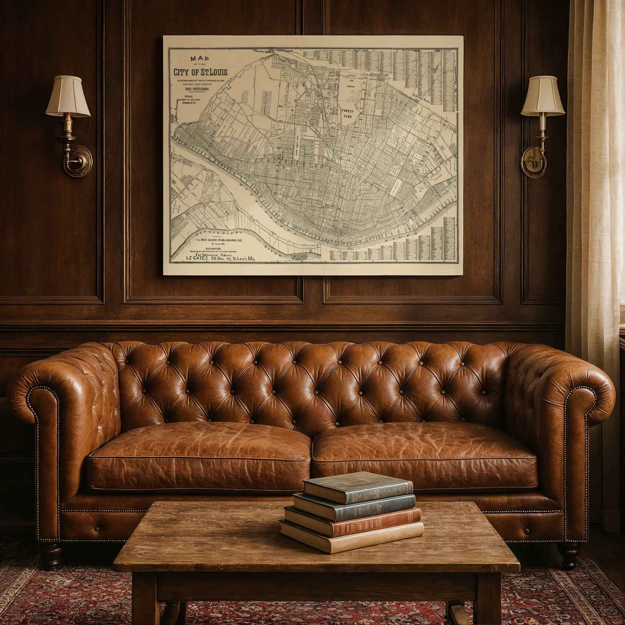

St. Louis Vintage Map 1876 - Historical City Charter Map by Charles Varrelmann
Discover the Gateway City's Foundation
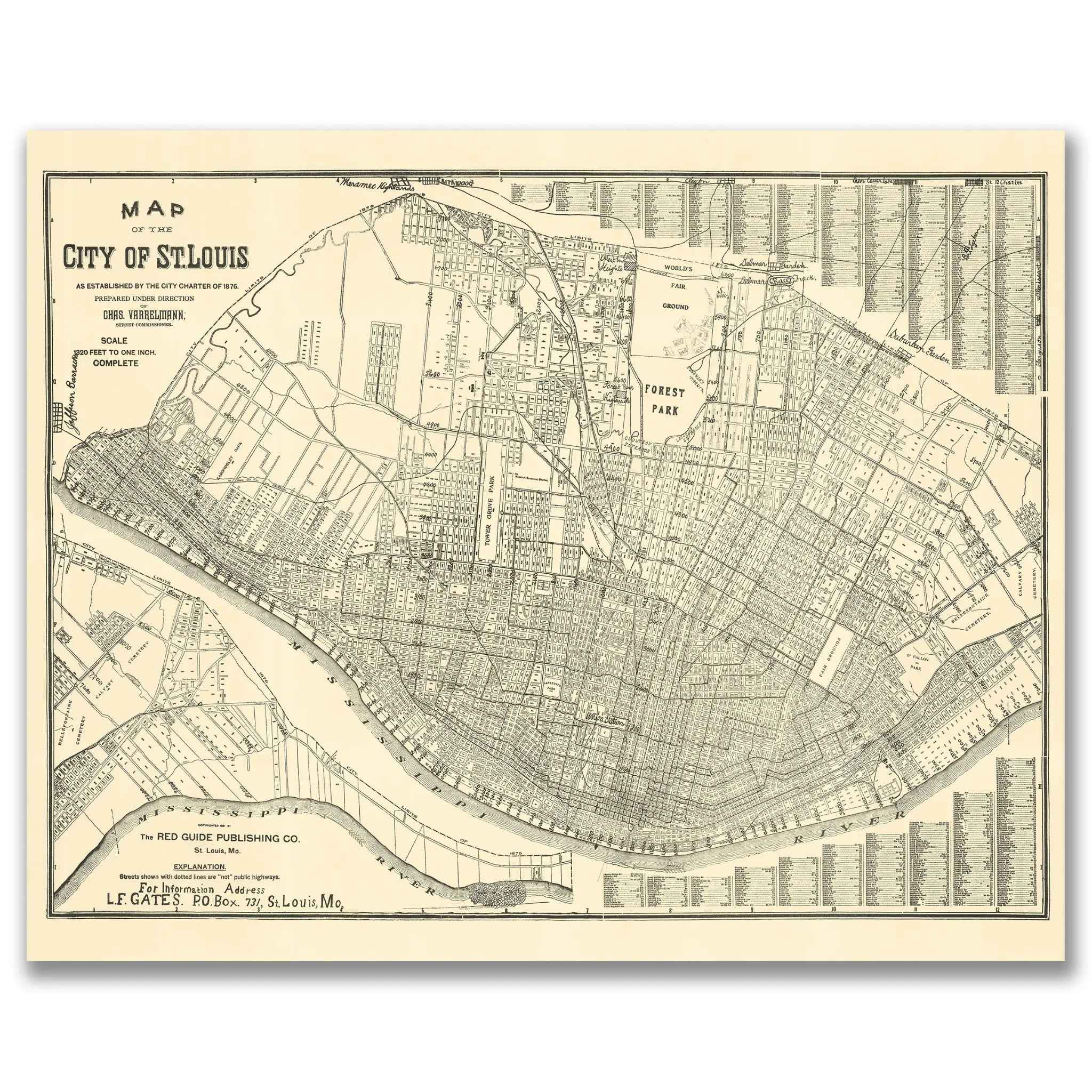
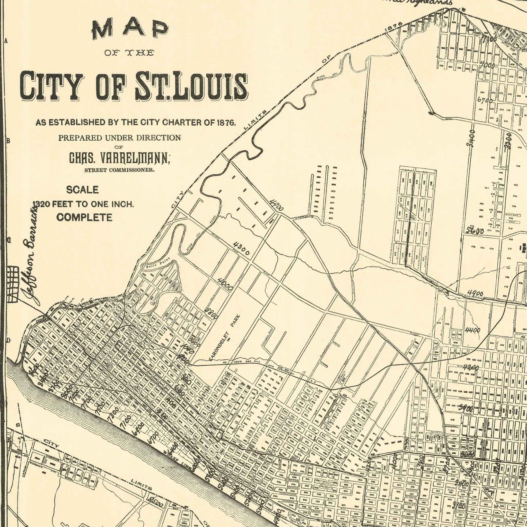
Step into the remarkable world of 1876 St. Louis with this meticulously detailed city map that captures Missouri's greatest metropolis during the year of America's Centennial celebration. Prepared under the direction of Charles Varrelmann, Street Commissioner, this extraordinary cartographic document reveals St. Louis as established by the City Charter of 1876, showcasing the Gateway City during its golden age as the fourth-largest city in America and the undisputed commercial capital of the American West.
Historical Significance
In 1876, St. Louis stood as the beating heart of American westward expansion and Mississippi River commerce, earning its nickname as the Gateway to the West. This official city map documents St. Louis during a pivotal moment when the city was experiencing unprecedented growth following the Civil War, with railroad networks converging from all directions and steamboat traffic making the riverfront one of the busiest commercial centers in the nation. The map showcases the city during the year it hosted visitors from around the world, when the famous Eads Bridge had recently connected Missouri and Illinois, and when Forest Park was being developed as one of America's great urban green spaces.
Cartographic Excellence
This masterful city map represents the pinnacle of 19th-century municipal cartography, combining precise surveying with comprehensive urban planning documentation. The detailed rendering reveals St. Louis's distinctive relationship with the Mississippi River, showing how the city's street grid follows the great river's curve while extending westward in orderly blocks toward the emerging suburbs. The map captures the essence of a city built for commerce and growth, with detailed street layouts, public spaces, and the careful documentation of wards and districts that made St. Louis a model of American urban development.
Urban Development Story
Within the carefully mapped streets and riverfront, the story of American urban expansion unfolds through the systematic layout of neighborhoods, commercial districts, and public spaces. The map captures St. Louis at the height of its influence as a transportation hub, featuring the bustling riverfront where steamboats connected the city to New Orleans and the upper Mississippi, while railroad lines radiated outward to connect the Gateway City to every corner of the expanding nation. The inclusion of Forest Park and other green spaces reflects the forward-thinking urban planning that made St. Louis a leader in American city development.
Gateway Heritage
Beyond its function as a municipal document, this map represents the vision and ambition that made St. Louis the symbol of American opportunity and westward expansion. The careful documentation of street systems, public buildings, and commercial districts reveals how the city was designed to accommodate both established residents and the constant flow of settlers, immigrants, and entrepreneurs heading west. The presence of the great river curve and the systematic street grid captures the unique geography and planning that made St. Louis the natural gateway between East and West.
This detailed cartographic record preserves St. Louis at a moment of tremendous pride and prosperity—when the city was celebrating America's Centennial while establishing itself as the commercial and cultural capital of the American interior. The map captures the essence of a community that valued both tradition and progress, creating the unique blend of Southern hospitality, Midwestern practicality, and Western ambition that defines St. Louis character. Perfect for St. Louis history enthusiasts, urban planning aficionados, and collectors of vintage city maps, this restored map serves as both a historical treasure and a stunning piece of wall art that celebrates the vision and determination that built the Gateway City.
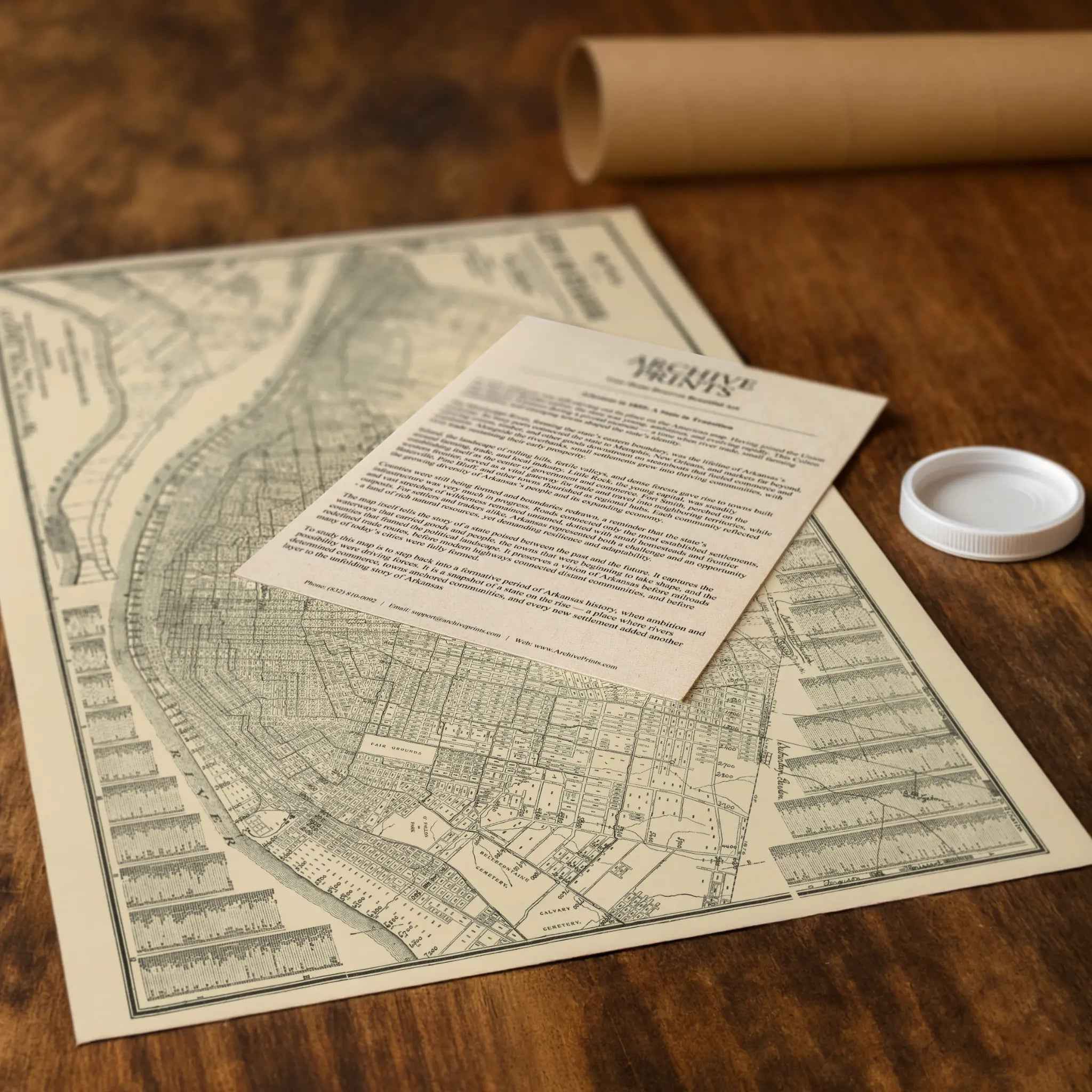
Each reproduction includes a custom historical letter detailing St. Louis's role in 19th-century American expansion and the unique geography and commerce that made the city the Gateway to the West. Printed on heavyweight archival paper or premium canvas, every street, river bend, and district boundary is preserved with museum-quality clarity through expert digital restoration.
For protection and presentation, paper prints arrive rolled in sturdy mailing tubes, while canvas prints come gallery-wrapped on solid pine stretcher bars with pre-installed hanging hardware—ready to display immediately.
Bring home a piece of Gateway City history with this captivating glimpse into St. Louis during its golden age as America's western commercial capital.
The Map Story
This detailed street map of St. Louis was published in 1876 by the Red Guide Publishing Company under the direction of Charles Variarblank. It coincides with one of the most important years in the city’s history. In 1876 St. Louis adopted its city charter that separated it from St. Louis County, making it an independent city. At the same time, the nation’s centennial celebrations and the city’s own rapid growth placed St. Louis firmly among America’s leading urban centers.
The map shows the city stretching in a great arc along the Mississippi River, from the old riverfront warehouses and levees southward past Carondelet, and westward toward the new residential districts. Each street is carefully drawn, while ward numbers, block divisions, and property lots give a sense of the city’s intricate civic structure. At the heart of the sheet lies Forest Park, then newly created in 1876. Covering more than 1,300 acres, it symbolized the city’s commitment to public space and recreation, and within a generation it would host the 1904 World’s Fair.
St. Louis in the 1870s was a place of remarkable transformation. Once a fur trading post and river port, it had become the fourth-largest city in the United States by the time this map was printed. Immigrants from Germany, Ireland, and many other nations filled its neighborhoods. Manufacturing districts hummed with activity, while railroads radiated out to connect the Mississippi Valley to the wider continent. This network of rails, shown clearly here, underscored St. Louis’s role as a gateway city between East and West.
The Mississippi River dominates the southern edge of the map. Steamboats still crowded its levees, carrying grain, coal, and manufactured goods. Bridges and ferry routes linked the city to Illinois across the water, further emphasizing its strategic position. In the city itself, streetcar lines, markets, and institutions of learning and culture all contributed to a bustling civic life.
This 1876 map not only provides a snapshot of urban form but also reflects civic pride during a pivotal year. The separation from St. Louis County allowed the city to control its finances and growth more directly, even as it limited future annexation. Combined with the dedication of Forest Park, the year 1876 became a cornerstone of identity. Seen today, the map is a record of ambition, diversity, and confidence, capturing St. Louis at the height of its nineteenth-century rise and before the transformations of the twentieth century.
Materials
Hand‑Stretched Canvas: If you choose canvas, we use a premium cotton‑poly blend stretched over solid pine frames. Each canvas is carefully hand‑stretched for a tight, gallery‑quality finish that's ready to hang right out of the box.
Vivid, Fade‑Resistant Inks: We use professional‑grade inks that are UV‑resistant, so your print retains its rich colors even when displayed in bright rooms.
Expert Restoration: Every map is digitally restored by skilled artisans. We preserve the character of the original while enhancing clarity, so you see the map as it was meant to be seen.
Secure Packaging: Paper prints are rolled in heavy‑duty mailing tubes, and canvases are cushioned in reinforced boxes to ensure they arrive in pristine condition.
Choosing one of our prints means investing in craftsmanship. We combine historical authenticity with modern print technology and premium materials, giving you a work of art built to stand the test of time.
Choose options

Because every place has a story
Make History Personal
A vintage map is more than art.
It is a reminder of where life began.
Where memories were made.
Where hearts still live. Give the gift of place.
Beautifully preserved and made for the moments that matter.
Why Choose Us?
| Feature | Us | Competitor A | Competitor B |
|---|---|---|---|
| Hand Crafted | |||
| Museum Quality | |||
| 100 Year Guarantee | |||
| Restored by Hand | |||
| Certificate of Authenticity |

Art Prints
Archival quality colors. Best option if you'd like to frame it yourself

The Best Materials
We hand-stretched our canvas on solid American-grown pine stretcher bars. We use quality canvas and fade-resistant inks to create the lasting art. Canvases come with hardware already installed and ready to hang.
Need help?
Frequently Asked Questions
Order
All of our maps are meticulously restored reproductions of historic originals. Each piece is digitally repaired and color-corrected to bring out the finest details while preserving its authentic, vintage character.
Yes. All Archive Prints products are printed to order in the USA with archival materials.
We offer two premium formats:
- High-Quality Paper Posters – Printed on thick, archival-grade matte paper for rich, vibrant detail.
- Hand-Stretched Canvas Prints – Printed on premium polycotton canvas and mounted on 1.5" solid American pine stretcher bars for a gallery-quality finish.
We carefully digitally restore each map to enhance clarity and color while preserving its original look and historic charm. You’ll enjoy sharp details and a timeless vintage aesthetic that feels true to the original piece.
Yes, we do! We offer premium framing options to make your map ready to hang the moment it arrives. You can choose from Oak, Maple, Black, or Walnut frames directly on the product page. We also offer Stretched Canvas prints for a modern gallery look, as well as archival-quality Posters if you prefer to frame it yourself.
Yes! We offer free shipping on all products within the United States. Each map is carefully packaged to ensure it arrives in perfect condition.
If you’re not completely satisfied, you can return your order in new condition for a full refund. Return shipping costs are the responsibility of the customer.
Absolutely! Our maps make thoughtful, one-of-a-kind gifts for history lovers, map collectors, or anyone looking to add vintage character to their home or office. Choose between paper prints for framing or stretched canvas for a ready-to-hang presentation.
- Paper Posters → Shipped in durable, protective tubes to prevent creasing.
- Canvas Prints → Carefully wrapped, padded, and boxed to ensure safe delivery.
Our maps look stunning in a variety of settings, including:
- Living rooms and home offices
- Libraries and studies
- Corporate offices and conference rooms
- Restaurants, cafes, and boutique spaces