


Texas Indian Territory Railway Map 1888 - Gulf Colorado & Santa Fe Railway Historical Print
Texas Indian Territory Railway Map 1888
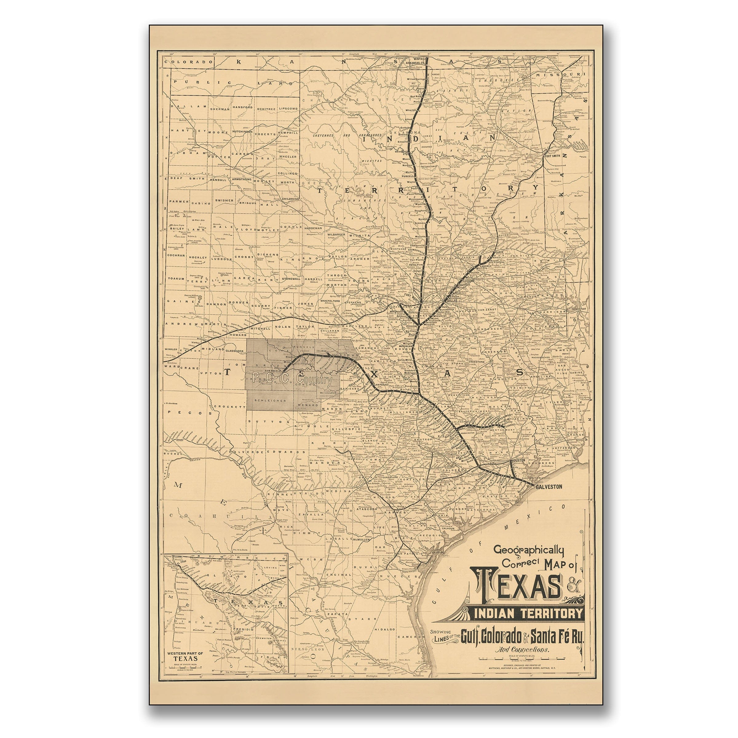
Travel back to 1888, when Texas was transforming from frontier isolation to industrial powerhouse. This Geographically Correct Map of Texas and Indian Territory Showing Lines of the Gulf, Colorado & Santa Fe Railway and Connections, published by the Gulf, Colorado & Santa Fe Railway Company of Galveston, captures a pivotal moment in the expansion of rail travel across the American Southwest. More than a geographic document, it was a powerful marketing tool designed to attract settlers, investors, and freight customers to a network that connected Texas to the rest of the country.
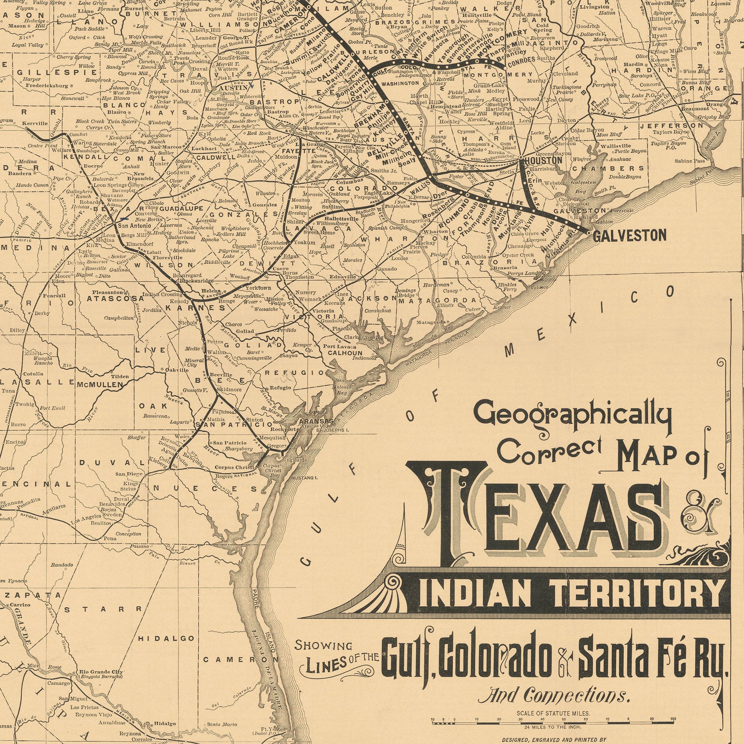
By the late 1880s, railroads had become the backbone of Texas commerce. The Gulf, Colorado & Santa Fe line stretched from the Gulf of Mexico at Galveston through the heart of the state, linking farming towns, cattle hubs, and industrial centers. Each bold line across this map represents more than steel and timber; it symbolizes progress, population growth, and the taming of once-isolated frontier lands.
The shaded regions and detailed county divisions reflect a state in motion. Settlements were growing rapidly, following the tracks that carried both goods and hope. Galveston served as the major coastal gateway, shipping cotton, grain, and livestock to distant markets. Inland towns such as Cleburne, Temple, and Brownwood flourished as division points and trade centers. The map's inset of far West Texas shows that even the remote desert regions were being surveyed and prepared for rail access.
Above Texas, the words "Indian Territory" stretch across what would later become Oklahoma. At the time, it remained a region of forced relocation and shifting tribal boundaries. The map quietly foreshadows change; survey lines and rail routes already edge into the territory, hinting at the coming era of statehood and settlement.
Printed in clear, functional lettering, this map was both a navigator's guide and a salesman's pitch. The phrase "Geographically Correct" emphasized the accuracy and professionalism of the railway company, reassuring travelers and investors that its routes were dependable and safe. Every element of the design projects confidence in a modern, connected Texas.
Viewed today, the map is a portrait of ambition. It captures the promise of a state rising from isolation to industry, from cattle trails to commerce. The Gulf, Colorado & Santa Fe line helped build that transformation, carrying not just freight and passengers, but the dream of progress that defined 19th-century America. Each reproduction includes a custom historical letter detailing the story behind the map, making it perfect for railroad enthusiasts, Texas history collectors, and anyone fascinated by the era of westward expansion.
Printed on heavyweight archival paper or hand-stretched polycotton canvas, every county line, rail route, and settlement is restored in museum-grade clarity for generations of enjoyment. Paper prints ship rolled in heavy-duty tubes, while canvas editions arrive gallery-wrapped on solid pine stretcher bars with pre-installed hardware—ready to display the moment it arrives.
Bring home a piece of Texas railroad heritage and celebrate the bold vision that connected the Southwest to the nation.
The Map Story
Materials
Choose options

Because every place has a story
Make History Personal
A vintage map is more than art.
It is a reminder of where life began.
Where memories were made.
Where hearts still live. Give the gift of place.
Beautifully preserved and made for the moments that matter.
Why Choose Us?
| Feature | Us | Competitor A | Competitor B |
|---|---|---|---|
| Hand Crafted | |||
| Museum Quality | |||
| 100 Year Guarantee | |||
| Restored by Hand | |||
| Certificate of Authenticity |

Art Prints
Archival quality colors. Best option if you'd like to frame it yourself

The Best Materials
We hand-stretched our canvas on solid American-grown pine stretcher bars. We use quality canvas and fade-resistant inks to create the lasting art. Canvases come with hardware already installed and ready to hang.
Need help?
Frequently Asked Questions
Order
All of our maps are meticulously restored reproductions of historic originals. Each piece is digitally repaired and color-corrected to bring out the finest details while preserving its authentic, vintage character.
Yes. All Archive Prints products are printed to order in the USA with archival materials.
We offer two premium formats:
- High-Quality Paper Posters – Printed on thick, archival-grade matte paper for rich, vibrant detail.
- Hand-Stretched Canvas Prints – Printed on premium polycotton canvas and mounted on 1.5" solid American pine stretcher bars for a gallery-quality finish.
We carefully digitally restore each map to enhance clarity and color while preserving its original look and historic charm. You’ll enjoy sharp details and a timeless vintage aesthetic that feels true to the original piece.
Yes, we do! We offer premium framing options to make your map ready to hang the moment it arrives. You can choose from Oak, Maple, Black, or Walnut frames directly on the product page. We also offer Stretched Canvas prints for a modern gallery look, as well as archival-quality Posters if you prefer to frame it yourself.
Yes! We offer free shipping on all products within the United States. Each map is carefully packaged to ensure it arrives in perfect condition.
If you’re not completely satisfied, you can return your order in new condition for a full refund. Return shipping costs are the responsibility of the customer.
Absolutely! Our maps make thoughtful, one-of-a-kind gifts for history lovers, map collectors, or anyone looking to add vintage character to their home or office. Choose between paper prints for framing or stretched canvas for a ready-to-hang presentation.
- Paper Posters → Shipped in durable, protective tubes to prevent creasing.
- Canvas Prints → Carefully wrapped, padded, and boxed to ensure safe delivery.
Our maps look stunning in a variety of settings, including:
- Living rooms and home offices
- Libraries and studies
- Corporate offices and conference rooms
- Restaurants, cafes, and boutique spaces