
Waco Vintage Historical Map - 1873 Texas City Map Art
Discover Waco's Frontier Heritage
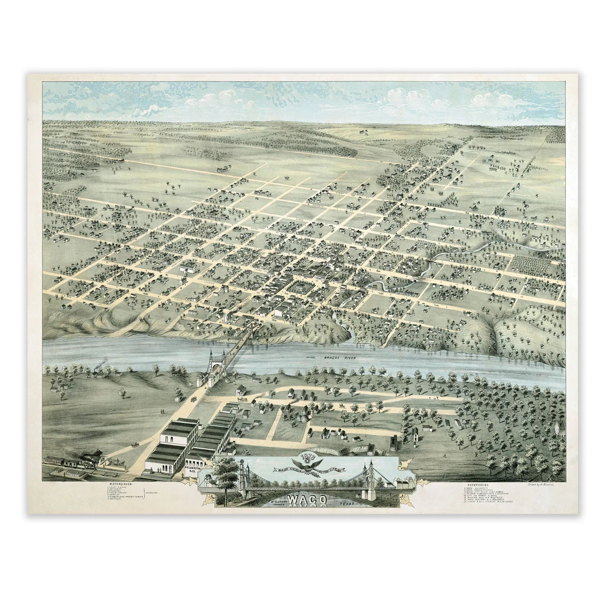
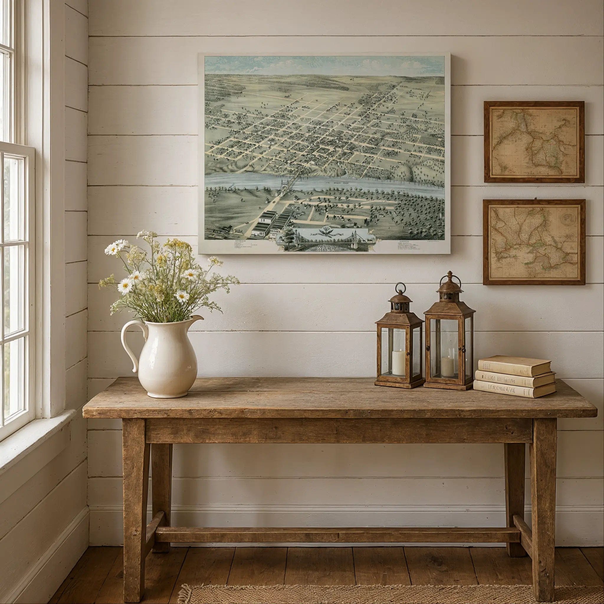
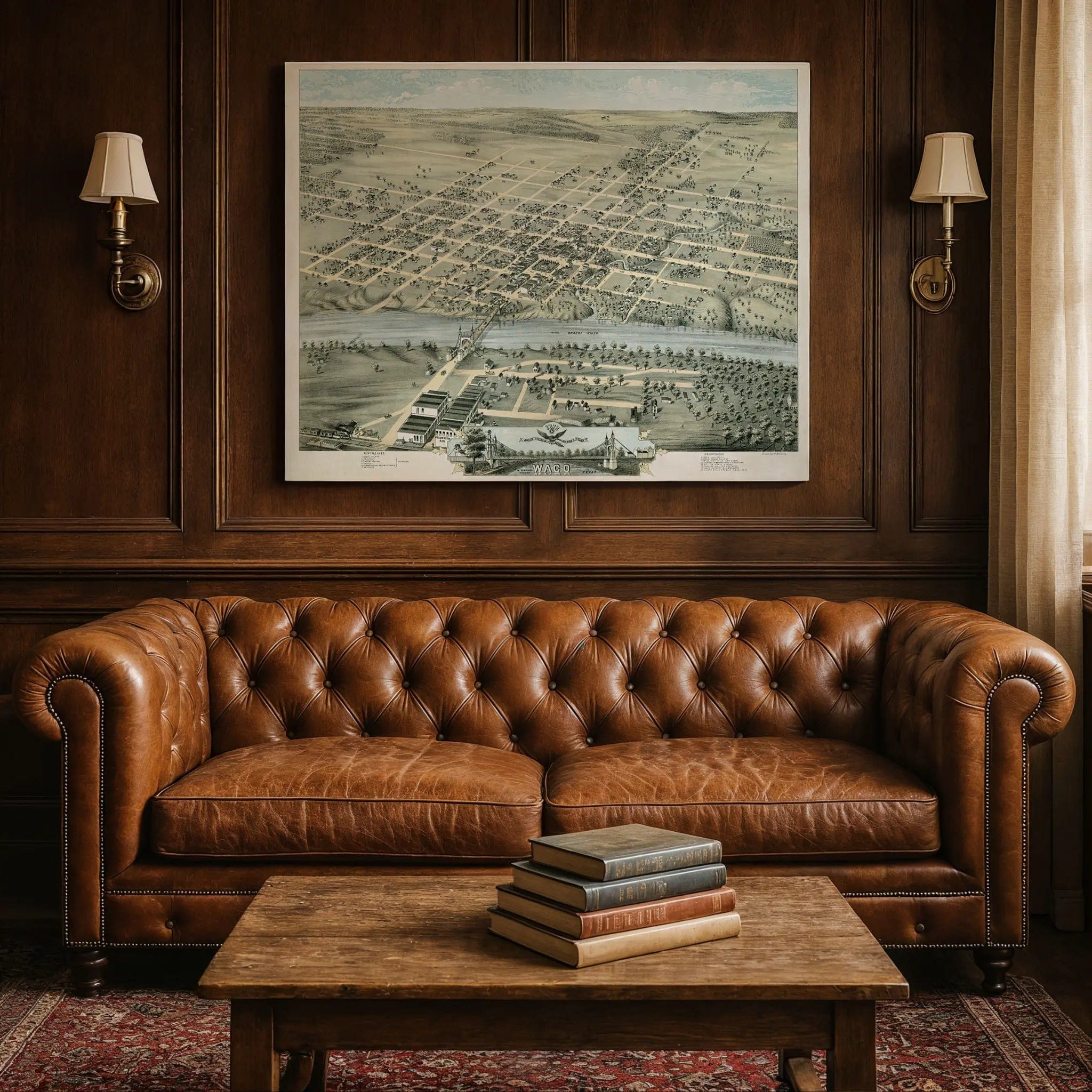
Step back into the heart of 1873 Texas with this extraordinary Bird's-Eye View of Waco by H. Brosius. This remarkable panoramic map captures the city at a pivotal moment in its history, when Waco sat beside the Brazos River as a confluence of ideas, ambition, and the slow transformation of frontier life into urban civilization. Every street, building, and bridge reflects a town less built than envisioned—where order, nature, and hope mingled on the Texas plain.
Historical Significance
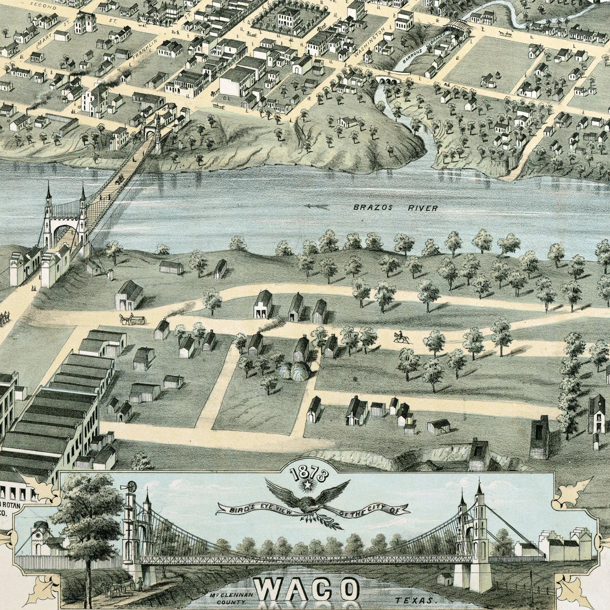
In 1873, Waco represented the promise of Texas development during Reconstruction. The map reveals a carefully planned community emerging along the Brazos River, with organized street grids pushing toward the riverside and beyond. Buildings cluster around the river, bridges, and principal thoroughfares, while structures thin toward the fringes where empty lots and open land remind us how new this place still was. The Brazos River snakes through the drawing, its curves shaping neighborhoods and defining the town's margins as both boundary and artery.
Cartographic Excellence
H. Brosius created this bird's-eye view with meticulous attention to civic ideals and commercial potential. Public buildings, churches, schools, and commercial blocks receive special emphasis, drawn with weight and detail to project permanence, respectability, and community. These anchor points lie close to the dense heart of town, signaling that Waco's identity centered not just on trade but on rooted civic life. The precise rendering shows grain mills, docks, and warehouses near the water—structures that tied Waco to trade, growth, and exchange.
Urban Development Story
Beyond the town's heart lies open terrain: fields, groves, undeveloped blocks, fences, and gentle rises. The map doesn't pretend these lands are empty wilderness; rather, they represent blank material—spaces awaiting settlement, subdivision, and transformation. The edges remain loose and porous, waiting for the town to push outward. This careful balance between built clusters and open margins suggests confidence that growth would come and connections would deepen.
A Vision Preserved
This map serves as both record and call, showing what Waco was in 1873—modest, functional yet hopeful—but also what it intended to become. The plotted lots, mix of built areas and open margins, and careful attention to infrastructure all suggest a community drawn in potential. Today, this 1873 map stands as a time capsule of a town forming before the boom, before the skyline, before the sprawl—capturing Waco at the moment when river and road, grid and greenery, aspiration and reality all stood side by side.
A Piece of Texas History
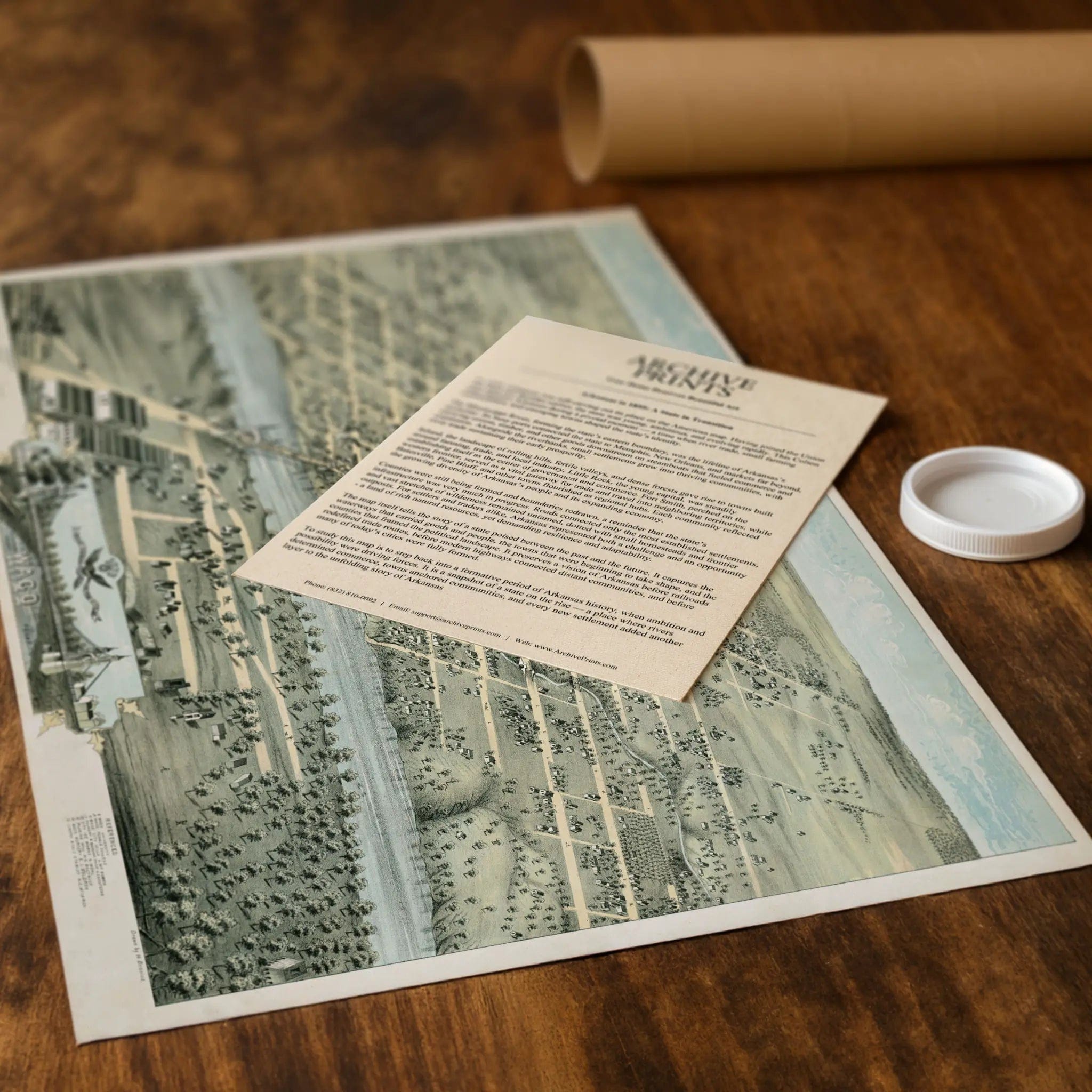
Each restored reproduction of this 1873 map is printed with museum-quality precision on heavyweight archival paper or hand-stretched premium canvas to preserve every original detail. Your purchase includes two companion documents:
Certificate of Authenticity verifying its restoration and reproduction quality
Historical Story Page detailing the origins, craftsmanship, and cultural significance of Brosius's iconic map
Paper prints arrive rolled in reinforced mailing tubes for protection. Canvas prints come gallery-wrapped on solid pine stretcher bars with pre-installed hardware, ready to display upon arrival.
Bring home a vivid piece of Texas history—a timeless record of Waco's frontier heritage and the vision that shaped one of Central Texas's most enduring communities.
The Map Story
In 1873, Waco, Texas sat beside the Brazos River, at the confluence of ideas, ambition, and the slow creep of urban life across the frontier. The Bird’s-Eye View of Waco invites the eye to drift over rooftops and along streets, to imagine a town less built than envisioned—where order, nature, and hope mingle on the Texas plain.
Seen from above, the map lays out Waco in an organized street grid, pushing toward the riverside and beyond. Buildings cluster around the river, the bridges, and the principal thoroughfares. As the structures spread outward, they thin—empty lots and open land dominate at the fringes, reminding us how new so much of this place still was.
The Brazos River snakes through the drawing, its curves shaping neighborhoods and defining the town’s margins. Bridges cross its flow, connecting blocks and enabling commerce. Near the water, you see grain mills, docks, warehouses—those structures that tie Waco to trade, growth, and exchange. The river is both boundary and artery, a natural force that settlers must respect even as they try to reshape the land.
Public buildings, churches, schools, and commercial blocks receive emphasis. They are drawn with weight and detail, marking the civic ideals the town wanted to project: permanence, respectability, community. These anchor points lie close to the dense heart of the town, signaling that Waco’s identity wasn’t just about trade but about rooted civic life.
Beyond that heart lies open terrain: fields, groves, undeveloped blocks, fences, and gentle rises. The map does not pretend these lands are empty wilderness; rather, they are blank material—spaces awaiting settlement, subdivision, and transformation. The edges remain loose, porous, waiting for the town to push outward.
This map is both record and call. It shows what Waco was in 1873—modest, functional yet hopeful—but also what it intended to become. The precise lines, the plotted lots, the mix of built clusters and open margins—all suggest confidence: that growth will come, that connections will deepen, that solidity will earn shape over time.
Today, that 1873 map stands as a time capsule. It captures a town forming, not yet matured; a place where looseness still held sway; where river and road, grid and greenery, aspiration and reality all stood side by side. In its lines and empty lots lies the memory of Waco before the boom, before the skyline, before the sprawl—a town drawn in potential.
Materials
Choose options

Because every place has a story
Make History Personal
A vintage map is more than art.
It is a reminder of where life began.
Where memories were made.
Where hearts still live. Give the gift of place.
Beautifully preserved and made for the moments that matter.
Why Choose Us?
| Feature | Us | Competitor A | Competitor B |
|---|---|---|---|
| Hand Crafted | |||
| Museum Quality | |||
| 100 Year Guarantee | |||
| Restored by Hand | |||
| Certificate of Authenticity |

Art Prints
Archival quality colors. Best option if you'd like to frame it yourself

The Best Materials
We hand-stretched our canvas on solid American-grown pine stretcher bars. We use quality canvas and fade-resistant inks to create the lasting art. Canvases come with hardware already installed and ready to hang.
Need help?
Frequently Asked Questions
Order
All of our maps are meticulously restored reproductions of historic originals. Each piece is digitally repaired and color-corrected to bring out the finest details while preserving its authentic, vintage character.
Yes. All Archive Prints products are printed to order in the USA with archival materials.
We offer two premium formats:
- High-Quality Paper Posters – Printed on thick, archival-grade matte paper for rich, vibrant detail.
- Hand-Stretched Canvas Prints – Printed on premium polycotton canvas and mounted on 1.5" solid American pine stretcher bars for a gallery-quality finish.
We carefully digitally restore each map to enhance clarity and color while preserving its original look and historic charm. You’ll enjoy sharp details and a timeless vintage aesthetic that feels true to the original piece.
Yes, we do! We offer premium framing options to make your map ready to hang the moment it arrives. You can choose from Oak, Maple, Black, or Walnut frames directly on the product page. We also offer Stretched Canvas prints for a modern gallery look, as well as archival-quality Posters if you prefer to frame it yourself.
Yes! We offer free shipping on all products within the United States. Each map is carefully packaged to ensure it arrives in perfect condition.
If you’re not completely satisfied, you can return your order in new condition for a full refund. Return shipping costs are the responsibility of the customer.
Absolutely! Our maps make thoughtful, one-of-a-kind gifts for history lovers, map collectors, or anyone looking to add vintage character to their home or office. Choose between paper prints for framing or stretched canvas for a ready-to-hang presentation.
- Paper Posters → Shipped in durable, protective tubes to prevent creasing.
- Canvas Prints → Carefully wrapped, padded, and boxed to ensure safe delivery.
Our maps look stunning in a variety of settings, including:
- Living rooms and home offices
- Libraries and studies
- Corporate offices and conference rooms
- Restaurants, cafes, and boutique spaces